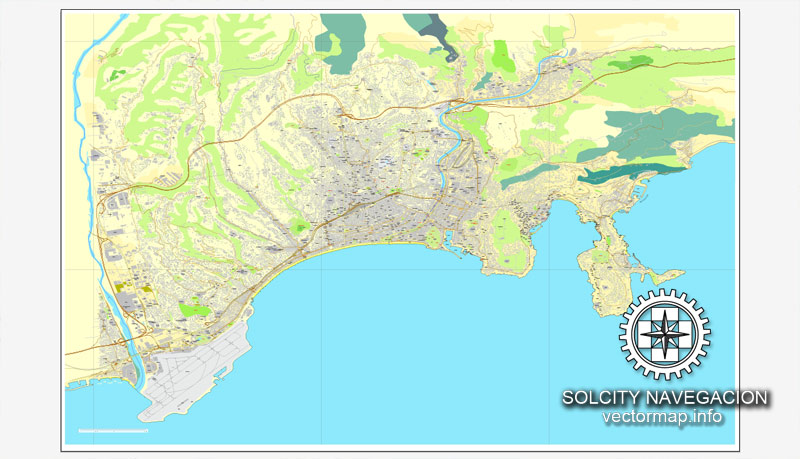
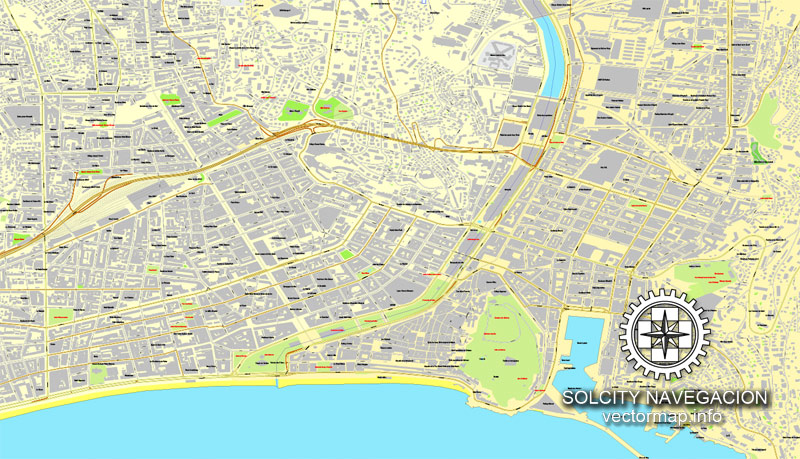
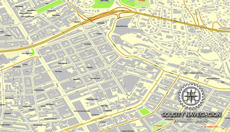
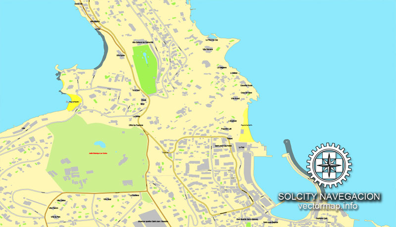
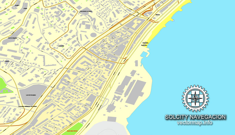
Nice printable vector street City Plan map, France,, fully editable, Adobe PDF, full vector, scalable, editable, text format of street names, 14 Mb ZIP.
All streets, All buildings. Map for design, print, arts, projects, presentations, for architects, designers and builders.
You can edit this file by Adobe Illustrator, Adobe Acrobat, Corel Draw.
The most accurate and detailed map of the city.
DXF, DWG, CDR and other formats – on request, same price, please, contact
Nice, France, rue vecteur imprimable Plan Plan de ville, plein modifiable, Adobe PDF, vectoriel complet,,, noms évolutives rue format texte modifiable, 14 mb ZIP
Toutes les rues, tous les bâtiments. Carte de conception, d’impression, des arts, des projets, des présentations,
pour les architectes, les concepteurs et les constructeurs.
DXF, DWG, CDR et d’autres formats – sur demande, même prix, s’il vous plaît, contactez
Nice, France.
This vector map of Nice is used as a basis for design, editing, and further printing.
This is the most detailed, exact map of Nice for high-quality printing and polygraphy. You can always clarify the map development date by contacting us.
For your convenience, all objects on Nice vector map are divided into layers. And the editing is very easy – colors, lines, etc.
You can easily add any objects needed (e.g. shops, salons, sale points, gas station or attraction) on any layer of Nice vector map.
Nice is the fifth most populous city in France and the capital of the Alpes-Maritimes département. The metropolitan area of Nice extends beyond the administrative city limits, with a population of about 1 million on an area of 721 km2 (278 sq mi). Located in the French Riviera, on the south east coast of France on the Mediterranean Sea, at the foot of the Alps, Nice is the second-largest French city on the Mediterranean coast and the second-largest city in the Provence-Alpes-Côte d’Azur region after Marseille. Nice is about 13 kilometres (8 miles) from the principality of Monaco, and its airport is a gateway to the principality as well.
One of the advantages of Nice vector maps of our production is the relevance of cartographic data, we constantly update all our products.
This vector map of Nice is used by:
designers, layout designers, printers, advertisers and architects. Our product – vector maps – is designed for further editing and printing in large formats – from @Wall format (a few meters) to A-0 and A-1, A-2, A-3.
Nice map in vector format is used for design, urban planning, presentations and media visualizations.
Advertising and presentation map of Nice (usually the final designer marks the routes, and puts the client’s objects (shops, saloons, gas stations etc.)
The undoubted advantage is that people will NEVER throw out this advertising product – the map. In fact, as an advertising medium, a map is the most “long-playing” of the well-known polygraphic advertising media, with the longest lifespan, and the maximum number of interactions with the customer.
For travelers, maps are sold at the airports and gas stations around the world. Often the source is our vector maps.
Take a look, who purchases our vector maps of Nice in “Our Clients and Friends” page – these are large and small companies, from super-brands like Volvo and Starbucks, to small design studios and printing houses.
It’s very easy to work with vector maps of Nice, even for a not very experienced designer who can turn on and off the map layers, add new objects, change the colors of fill and lines according to customer requirements.
The undoubted advantage of Nice vector maps in printing is an excellent and detailed visualization, when customer can expand a large paper map and instantly define his location, find a landmark, an object or address on map, unlike using the popular electronic formats of Google and Yandex maps for example.
Printable vector maps of Nice are much more convenient and efficient than any electronic maps on your smartphone, because ALL DETAILS are displayed in the entire space of Nice map.
Useful tips on working with vector maps of cities and countries in Adobe Illustrator.
«V» – launches the Selection tool (cursor, black arrow), which makes active any vector line.
«А» – launches the Direct Selection tool (white cursor), allows you to select curve elements and drag them to the desired place.
«R» – activates the Rotate tool, which helps you rotating selected objects around the center point by 360 degrees.
«E» – gives you the opportunity to use the Eraser tool and erase unnecessary parts.
«X» – switches between Fill and Stroke in the Tools section. Try to get used to this hot key and
you will quickly understand that you can’t live and work without it.
Guides are not limited to vertical and horizontal in Adobe Illustrator. You can also create a diagonal guide for example. Moreover, you can turn any contours into guides. Select the outline and go to View > Guides > Make Guides (Create Guides), or simply press Cmd/Ctrl + 5. You can also turn the guides back into an editable object. Go to menu, View > Guides > Unlock Guides (Release Guides), select the guide you want to edit and select View > Guides > Release Guides (Reset Guides), or just press Cmd/Ctrl + Option / Alt + 5).
You will probably want to change the color scheme used on our Nice vector map.
To quickly and effectively play with colors.
Of course, you can do it manually, all objects in our Nice vector map are divided according to types and layers, and you can easily change the color gamma of vector objects in groups and layers.
But there is more effective way of working with the whole VECTOR MAP of Nice and all layers:
The overview dialog «Edit colors»/«Repaint Graphic Object» (this dialog box name can change depending on the context):
If you have selected a part or a layer of Nice vector map and open the dialog box by clicking the icon in the Control panel, on the Samples palette or the Color Catalog, or if you choose Edit > Edit Colors> Repaint Graphic Object, then the «Repaint Graphic Object» dialog box appears, and you get access to «Assign» and «Edit» tabs.
If a picture or a map fragment is not selected, and you open the dialog box by clicking the icon in the Control panel, on the Samples palette or in the Color Catalog, the «Edit Colors» dialog box appears and you can only access the «Edit» tab.
Regardless of the name at the top of the dialog box, the right-hand side always displays the color group of the current document, as well as two default color groups: Print Color and Grayscale. These color groups can be selected and used any time.
Create and edit color groups of Nice vector map, and also assign colors using the «Edit Colors»/ а «Repaint Graphic Object» dialog box.
A. Creating and editing of a color group on the «Edit» tab
B. Assigning colors on the «Assign» tab
C. Select a group of colors from the «Color groups» list
The option «Repaint a graphic object» in the lower part of the dialog box allows you to preview the colors on a selected layer of Vector map, or a group of elements, and specify whether its colors will be redefined when the dialog box is closed.
The main areas of the dialog box are:
«Edit»
The «Edit» tab is designed to create a new or edit the existing color groups.
The harmony rules Menu and the Color Wheel are used to conduct experiments with color harmonies. The color wheel shows how colors are related in color harmony, and the color bars allow you to view and manipulate an individual color values. In addition, you can adjust the brightness, add and remove colors, save color groups and view colors on the selected Vector Map of Nice or a separated layers.
«Assign»
The «Assign» tab is used to view and control on how the original colors are replaced with colors from the color group like your corporate colors in the Vector Map of Nice.
The assign color ability is provided only if the entire map, layer or fragment is selected in the document. You can specify which of new colors replace the current colors, whether the spot colors should be preserved and how colors are replaced (for example, you can replace colors completely or changing the color tone while maintaining the brightness). The «Assign» tab allows you to redefine colors in the Vector Map of Nice, or in separate layers and fragments using the current color group or reducing the number of colors in the current Vector Map.
Color groups
Is a list of all saved color groups for current document (the same groups appear in the «Samples» palette). You can edit and delete the existing color groups, as well as creating a new ones using the list of “Color Groups” in the dialog box. All changes appear in the «Samples» palette.
The highlighted color group shows, which color group is currently edited.
Any color group can be selected and edited, or used to redefine the colors in the selected vector map of Nice, its fragments or elements.
Saving a color group adds this group to the specified list.
Opening the «Edit Colors»/«Repaint Graphic Object» dialog box.
Open the «Edit Colors»/«Repaint Graphic Object» dialog box using one of the following methods:
«Edit»> «Edit Colors»> «Repaint Graphic object» or «Repaint With Style».
The city is nicknamed Nice la Belle (Nissa La Bella in Niçard), which means Nice the Beautiful, which is also the title of the unofficial anthem of Nice, written by Menica Rondelly in 1912.
The area of today’s Nice contains Terra Amata, an archaeological site which displays evidence of a very early use of fire. Around 350 BC, Greeks of Marseille founded a permanent settlement and called it Nikaia, after Nike, the goddess of victory. Through the ages, the town has changed hands many times. Its strategic location and port significantly contributed to its maritime strength. For centuries it was a dominion of Savoy, and was then part of France between 1792 and 1815, when it was returned to Piedmont-Sardinia until its re-annexation by France in 1860.
The natural beauty of the Nice area and its mild Mediterranean climate came to the attention of the English upper classes in the second half of the 18th century, when an increasing number of aristocratic families took to spending their winters there. The city’s main seaside promenade, the Promenade des Anglais (“Walkway of the English”) owes its name to visitors to the resort. The clear air and soft light have particularly appealed to notable painters, such as Marc Chagall, Henri Matisse, Niki de Saint Phalle and Arman. Their work is commemorated in many of the city’s museums, including Musée Marc Chagall, Musée Matisse and Musée des Beaux-Arts. Nice has the second largest hotel capacity in the country and it is one of its most visited cities, receiving 4 million tourists every year. It also has the third busiest airport in France, after the two main Parisian ones. It is the historical capital city of the County of Nice (Comté de Nice).
Geography
Nice consists of two large bays. Villefranche-sur-Mer sits on an enclosed bay, while the main expanse of the city lies between the old port city and the Aeroport de Côte d’Azur, across a gently curving bay. The city rises from the flat beach into gentle rising hills, then is bounded by surrounding mountains that represent the Southern and nearly the Western extent of the Ligurian Alps range.
Use these commands if you need to edit the colors in the selected vector map of Nice.
«Repaint Graphic object» button on the «Control» panel.
Use this button if you need to adjust colors of Nice vector map using the а «Repaint graphic object» dialog box.
The specified button is available if the selected vector map or its fragment contains two or more colors.
Note. This color editing method is convenient for global color adjustment in a vector map, if global colors were not used when creating a Map of Nice.
The «Edit colors» button or «Edit or apply colors» on the «Color Catalog» palette
Click this button if you need to edit colors on the «Color Catalog» palette or edit and then apply them to the selected Vector Map of Nice or its fragment.
The «Edit color group» button or «Edit or apply color group» on the «Samples» palette.
Click this button if you need to edit the colors in the specific color group or edit and apply them to the selected Vector Map of Nice or a group of its elements, for example, the whole layer “Streets and lines”. You can also double-click the color group in the Samples panel to open the dialog box.
If the map file is too large and your computer freezes or even can’t open it quickly:
1. Try to reduce the color resolution of the video card (display) to 256 colors while working with a large map.
2. Using Windows Task Manager, select all the application you don’t need, while working with map, just turn them off.
3. Launch Adobe Illustrator. (DO NOT OPEN the vector map file)
4. Start the Windows Task Manager using administrator rights > Find the “Illustrator” process > set the «real time» priority,
5. Open the file. When you see the LEGACY FONT popup window – click “OK” (do not update). You can restore the TEXT later.
6. Can also be useful: When file is opened – Edit > Settings > Basic Settings > disable smoothing. /// It looks scary, but works quickly)))
We recommend saving the file in Adobe Illustrator 10 version. It’s much more stable when working with VERY BIG size files.
Small guide: How to work with the vector map?
You can: Mass select objects by type and color – for example, the objects type “building” (they are usually dark gray) – and remove them from the map, if you do not need them in your print or design project. You can also easily change the thickness of lines (streets), just bulk selection the road by the line color.
The streets are separated by type, for example, type “residential road” are usually white with a gray stroke. Highway usually orange with a brown or dark gray stroke.
It is easy to change the font of inscriptions, all or each individually. Also, just can be make and any other manipulation of objects on the vector map in Adobe illustrator format.
Important: All the proportions on the map are true, that is, the relative sizes of the objects are true, because Map is based on an accurate GPS projection, and It transated into the (usual for all) the Mercator projection.
You can easily change the color, stroke and fill of any object on the map, zoom without loss of quality Image Verification.
Select object

Bulk selection the same objects on the vector map

See the bulk selected objects on the vector map

Bulk delete buildungs from the vector map

Select residencial road (small street) on the vector map

Bulk selection the same lines (streets, roads) on the full map

Create fat lines of the streets on the vector maps (bulk action) 1

Create fat lines of the streets on the vector maps (bulk action) 2

Create fat lines of the streets on the vector maps (bulk action) 3

You can easily change the color, stroke and fill of any object on the map, zoom without loss of quality Image Verification.
Nice; Niçard Occitan: Niça, classical norm, or Nissa, nonstandard, pronounced [ˈnisa]; Italian: Nizza [ˈnittsa]; Greek: Νίκαια; Latin: Nicaea) is the fifth most populous city in France and the capital of the Alpes-Maritimes département. The urban area of Nice extends beyond the administrative city limits, with a population of about 1 million on an area of 721 km2 (278 sq mi). Located in the French Riviera, on the south east coast of France on the Mediterranean Sea, at the foot of the Alps. Nice is the second-largest French city on the Mediterranean coast and the second-largest city in the Provence-Alpes-Côte d’Azur region after Marseille. Nice is about 13 kilometres (8 miles) from the principality of Monaco, and its airport is a gateway to the principality as well.
The city is nicknamed Nice la Belle (Nissa La Bella in Niçard), which means Nice the Beautiful, which is also the title of the unofficial anthem of Nice, written by Menica Rondelly in 1912.
The area of today’s Nice vector map pdf contains Terra Amata, an archaeological site which displays evidence of a very early use of fire. Around 350 BC, Greeks of Marseille founded a permanent settlement and called it Nikaia, after Nike, the goddess of victory. Through the ages, the town has changed hands many times. Its strategic location and port significantly contributed to its maritime strength. For centuries it was a dominion of Savoy, and was then part of France between 1792 and 1815, when it was returned to Piedmont-Sardinia until its re-annexation by France in 1860.
The natural beauty of the Nice area map and its mild Mediterranean climate came to the attention of the English upper classes in the second half of the 18th century, when an increasing number of aristocratic families took to spending their winters there. The city’s main seaside promenade, the Promenade des Anglais (“Walkway of the English’) owes its name to visitors to the resort. For decades now, the picturesque Nicean surroundings have attracted not only those in search of relaxation, but also those seeking inspiration. The clear air and soft light have particularly appealed to some of Western culture’s most outstanding painters, such as Marc Chagall, Henri Matisse, Niki de Saint Phalle and Arman. Their work is commemorated in many of the city’s museums, including Musée Marc Chagall, Musée Matisse and Musée des Beaux-Arts. Nice has the second largest hotel capacity in the country and it is one of its most visited cities, receiving 4 million tourists every year. It also has the third busiest airport in France, after the two main Parisian ones. It is the historical capital city of the County of Nice (Comté de Nice).
Vegetation and geography of Nice
The natural vegetation of Nice is typical for a Mediterranean landscape, with a heavy representation of broadleaf evergreen shrubs. Trees tend to be scattered but form dense forests in some areas. Large native tree species include evergreens such as holm oak, stone pine and arbutus. Many introduced species grow in parks and gardens. Palms, eucalyptus and citrus fruits are among the trees which give Nice vector map a subtropical appearance. But there are also species familiar to temperate areas around the world; examples include horse chestnut, linden and even Norway spruce.
Geographically, Nice printable map consists of two large bays. Villefranche-sur-Mer sits on an enclosed bay, while the main expanse of the city lies between the old port city and the Aeroport de Côte d’Azur, across a gently curving bay. The city rises from the flat beach into gentle rising hills, then is bounded by surrounding mountains that represent the Southern and nearly the Western extent of the Ligurian Alps range.
Source
Nice (prononcé [nis]) (Nissa ou Niça en occitan niçois, Nizza ou Nizza Marittima en italien) est une commune du Sud-Est de la France, préfecture du département des Alpes-Maritimes et deuxième ville de la région Provence-Alpes-Côte d’Azur derrière Marseille. Située à l’extrémité sud-est de la France, à une trentaine de kilomètres de la frontière italienne, elle est établie sur les bords de la mer Méditerranée, le long de la baie des Anges et à l’embouchure du Paillon.
Avec 342 295 habitants au dernier recensement de 2013, elle est la cinquième commune de France en population (après Paris, Marseille, Lyon et Toulouse). Son agglomération est également la cinquième de France (après Paris, Lyon, Marseille et Lille) et regroupe 943 695 habitants (2012)1. Elle est située au cœur de la septième aire urbaine de France, avec 1 004 914 habitants en 20122. La ville est le centre d’une métropole, Nice Côte d’Azur3, qui rassemble quarante-neuf communes et 537 769 habitants en 20124, 536 327 en 2013. La population du Scot de Nice (Schéma de cohérence territoriale), créé en 2003 et regroupant vingt-neuf communes, est estimée à 517 500 habitants en 20055.
Située entre mer et montagnes, capitale économique et culturelle de la Côte d’Azur, Nice bénéficie d’importants atouts naturels. Le tourisme, le commerce et les administrations (publiques ou privées) occupent une place importante dans l’activité économique de la ville. Elle possède la deuxième capacité hôtelière du pays6, après Paris, et accueille chaque année 4 millions de touristes7. Elle dispose également du troisième aéroport de France8,9 (le premier de Province) et de deux palais des congrès consacrés au tourisme d’affaires. La ville possède aussi une université et plusieurs quartiers d’affaires. Nice est enfin dotée de certains équipements culturels importants. Elle possède ainsi de nombreux musées (il s’agit même de la ville qui en compte le plus en France, après Paris), un théâtre national, un opéra, une bibliothèque à vocation régionale, un conservatoire à rayonnement régional et des salles de concert.
Capitale historique du Comté de Nice, elle a appartenu à la Provence avant d’en faire sécession et de choisir de rejoindre les États de Savoie en 1388 (Acte de Dédition). En 1713, la Savoie obtient, par héritage, la Sicile qu’elle échange ensuite en 1720 avec le Royaume de Piémont-Sardaigne. Ce nouvel ensemble, installé des deux côtés des Alpes, forme ainsi l’un des États italiens pré-unitaires, dont la capitale est fixée à Turin. Nice ne devient définitivement française qu’en 1860, un an avant la réalisation de l’unité italienne. Ses habitants sont appelés les Niçoises et Niçois (Nissarda et Nissart en niçois).
Géographie Nice
Nice est située dans l’extrême sud-est de la France continentale, non loin de la frontière italienne (trente kilomètres), au bord de la Méditerranée. Elle fait partie de la Riviera dont elle est l’extrémité occidentale. Elle est bordée par la baie des Anges, et est entourée de plusieurs collines. La cité est située à 960 km de Paris, 230 km de Marseille, la capitale régionale, 200 km de Gênes, et 216 km de Turin. Il s’agit de la plus grande ville de la Côte d’Azur, territoire s’étendant d’Hyères à Menton. La ville se trouve en position excentrée par rapport au territoire national, comme au sein de la région Provence-Alpes-Côte d’Azur.
Source
See more Printable and Editable vector street maps of France
For example: Paris vector street map, France
Nice France Printable Vector Street city plan
Lille France Printable Vector Street map

 Author: Kirill Shrayber, Ph.D. FRGS