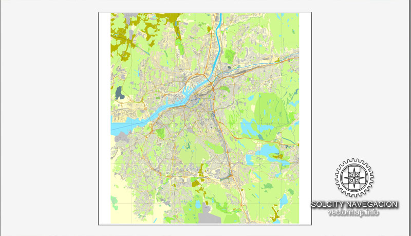
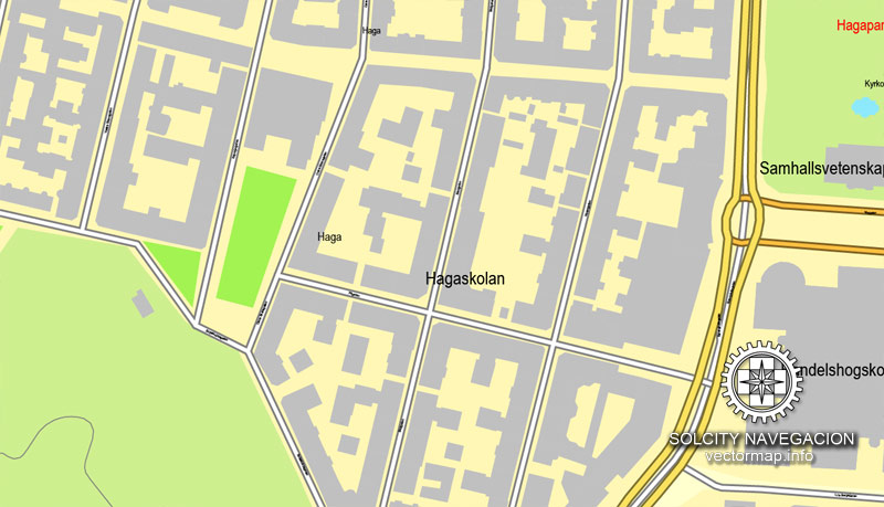
Gothenburg, Sweden, printable vector street City Plan map, fully editable, Adobe PDF, full vector, scalable, editable, text format of street names, 18 Mb ZIP
All streets, all buildings. Map for design, print, arts, projects.
You can edit this file in Adobe Illustrator, Adobe Acrobat, Corel Draw.
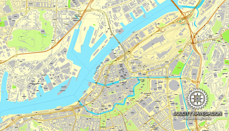
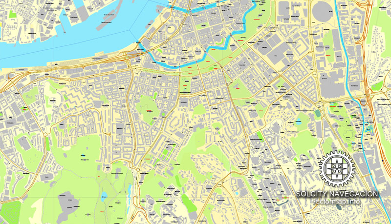
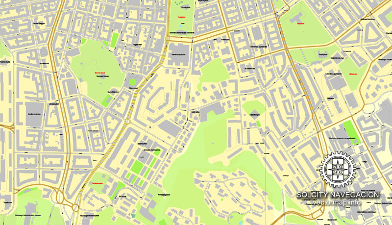
The most accurate and detailed map of Gothenburg city.
CDR, DWG, DXF and other formats – by request, same price, please contact.
Göteborg, Sverige, tryckbar vektor gata stadsplan kartlägga , mycket redigerbara, Adobe PDF, full vektor, skalbara , redigerbara, textformat gatunamn, 18 Mb ZIP.
Alla gator, alla byggnader. Map for design, tryck, konst, projekt.
Gothenburg, Sweden.
This vector map of Gothenburg city is used as a basis for design, editing, and further printing.
This is the most detailed, exact map of Gothenburg city for high-quality printing and polygraphy. You can always clarify the map development date by contacting us.
For your convenience, all objects on Gothenburg vector city map are divided into layers. And the editing is very easy – colors, lines, etc.
You can easily add any objects needed (e.g. shops, salons, sale points, gas station or attraction) on any layer of Gothenburg vector map.
Gothenburg is the second-largest city in Sweden and the fifth-largest in the Nordic countries, and part of Västra Götaland County. It is situated by Kattegat, on the west coast of Sweden, and has a population of approximately 570,000 in the city center and about 1 million inhabitants in the metropolitan area.
One of the advantages of Gothenburg city vector maps of our production is the relevance of cartographic data, we constantly update all our products.
This vector map of Gothenburg city is used by:
designers, layout designers, printers, advertisers and architects. Our product – vector maps – is designed for further editing and printing in large formats – from @Wall format (a few meters) to A-0 and A-1, A-2, A-3.
The Gothenburg city map in vector format is used for design, urban planning, presentations and media visualizations.
The advertising and presentation map of Gothenburg city (usually the final designer marks the routes, and puts the client’s objects (shops, saloons, gas stations etc.)
The undoubted advantage is that people will NEVER throw out this advertising product – the map. In fact, as an advertising medium, a city map is the most “long-playing” of the well-known polygraphic advertising media, with the longest lifespan, and the maximum number of interactions with the customer.
For travelers, maps are sold at the airports and gas stations around the world. Often the source is our vector maps.
Take a look, who purchases our vector maps of Gothenburg city in “Our Clients and Friends” page – these are large and small companies, from super-brands like Volvo and Starbucks, to small design studios and printing houses.
It’s very easy to work with vector maps of Gothenburg city, even for a not very experienced designer who can turn on and off the map layers, add new objects, change the colors of fill and lines according to customer requirements.
The undoubted advantage of Gothenburg city vector maps in printing is an excellent and detailed visualization, when customer can expand a large paper map and instantly define his location, find a landmark, an object or address on map, unlike using the popular electronic formats of Google and Yandex maps for example.
Printable vector maps of Gothenburg city are much more convenient and efficient than any electronic maps on your smartphone, because ALL DETAILS are displayed in the entire space of Gothenburg city map.
Useful tips on working with vector maps of cities and countries in Adobe Illustrator.
«V» – launches the Selection tool (cursor, black arrow), which makes active any vector line.
«А» – launches the Direct Selection tool (white cursor), allows you to select curve elements and drag them to the desired place.
«R» – activates the Rotate tool, which helps you rotating selected objects around the center point by 360 degrees.
«E» – gives you the opportunity to use the Eraser tool and erase unnecessary parts.
«X» – switches between Fill and Stroke in the Tools section. Try to get used to this hot key and
you will quickly understand that you can’t live and work without it.
Guides are not limited to vertical and horizontal in Adobe Illustrator. You can also create a diagonal guide for example. Moreover, you can turn any contours into guides. Select the outline and go to View > Guides > Make Guides (Create Guides), or simply press Cmd/Ctrl + 5. You can also turn the guides back into an editable object. Go to menu, View > Guides > Unlock Guides (Release Guides), select the guide you want to edit and select View > Guides > Release Guides (Reset Guides), or just press Cmd/Ctrl + Option / Alt + 5).
You will probably want to change the color scheme used on our Gothenburg vector city map.
To quickly and effectively play with colors.
Of course, you can do it manually, all objects in our Gothenburg city vector map are divided according to types and layers, and you can easily change the color gamma of vector objects in groups and layers.
But there is more effective way of working with the whole VECTOR MAP of Gothenburg city and all layers:
The overview dialog «Edit colors»/«Repaint Graphic Object» (this dialog box name can change depending on the context):
If you have selected a part or a layer of Gothenburg city vector map and open the dialog box by clicking the icon in the Control panel, on the Samples palette or the Color Catalog, or if you choose Edit > Edit Colors> Repaint Graphic Object, then the «Repaint Graphic Object» dialog box appears, and you get access to «Assign» and «Edit» tabs.
If a picture or a map fragment is not selected, and you open the dialog box by clicking the icon in the Control panel, on the Samples palette or in the Color Catalog, the «Edit Colors» dialog box appears and you can only access the «Edit» tab.
Regardless of the name at the top of the dialog box, the right-hand side always displays the color group of the current document, as well as two default color groups: Print Color and Grayscale. These color groups can be selected and used any time.
Create and edit color groups of Gothenburg city vector map, and also assign colors using the «Edit Colors»/ а «Repaint Graphic Object» dialog box.
A. Creating and editing of a color group on the «Edit» tab
B. Assigning colors on the «Assign» tab
C. Select a group of colors from the «Color groups» list
The option «Repaint a graphic object» in the lower part of the dialog box allows you to preview the colors on a selected layer of Vector map, or a group of elements, and specify whether its colors will be redefined when the dialog box is closed.
Gothenburg was founded as a heavily fortified, primarily Dutch, trading colony, by royal charter in 1621 by King Gustavus Adolphus. In addition to the generous privileges (e.g. tax relaxation) given to his Dutch allies from the then-ongoing Thirty Years’ War, the king also attracted significant numbers of his German and Scottish allies to populate his only town on the western coast. At a key strategic location at the mouth of the Göta älv, where Scandinavia’s largest drainage basin enters the sea, the Port of Gothenburg is now the largest port in the Nordic countries.
The main areas of the dialog box are:
«Edit»
The «Edit» tab is designed to create a new or edit the existing color groups.
The harmony rules Menu and the Color Wheel are used to conduct experiments with color harmonies. The color wheel shows how colors are related in color harmony, and the color bars allow you to view and manipulate an individual color values. In addition, you can adjust the brightness, add and remove colors, save color groups and view colors on the selected Vector Map of Gothenburg city or a separated layers.
«Assign»
The «Assign» tab is used to view and control on how the original colors are replaced with colors from the color group like your corporate colors in the Vector Map of Gothenburg city.
The assign color ability is provided only if the entire map, layer or fragment is selected in the document. You can specify which of new colors replace the current colors, whether the spot colors should be preserved and how colors are replaced (for example, you can replace colors completely or changing the color tone while maintaining the brightness). The «Assign» tab allows you to redefine colors in the Vector Map of Gothenburg city, or in separate layers and fragments using the current color group or reducing the number of colors in the current Vector Map.
Gothenburg is home to many students, as the city includes the University of Gothenburg and Chalmers University of Technology. Volvo was founded in Gothenburg in 1927. The original parent Volvo Group and the now separate Volvo Car Corporation are still headquartered on the island of Hisingen in the city. Other key companies are SKF and Astra Zeneca.
Color groups
Is a list of all saved color groups for current document (the same groups appear in the «Samples» palette). You can edit and delete the existing color groups, as well as creating a new ones using the list of “Color Groups” in the dialog box. All changes appear in the «Samples» palette.
The highlighted color group shows, which color group is currently edited.
Any color group can be selected and edited, or used to redefine the colors in the selected vector map of Gothenburg city, its fragments or elements.
Saving a color group adds this group to the specified list.
Opening the «Edit Colors»/«Repaint Graphic Object» dialog box.
Open the «Edit Colors»/«Repaint Graphic Object» dialog box using one of the following methods:
«Edit»> «Edit Colors»> «Repaint Graphic object» or «Repaint With Style».
Use these commands if you need to edit the colors in the selected vector map of Gothenburg city.
«Repaint Graphic object» button on the «Control» panel.
Use this button if you need to adjust colors of Gothenburg city vector map using the а «Repaint graphic object» dialog box.
The specified button is available if the selected vector map or its fragment contains two or more colors.
Note. This color editing method is convenient for global color adjustment in a vector map, if global colors were not used when creating a City Map of Gothenburg.
The «Edit colors» button or «Edit or apply colors» on the «Color Catalog» palette
Click this button if you need to edit colors on the «Color Catalog» palette or edit and then apply them to the selected Vector Map of Gothenburg city or its fragment.
The «Edit color group» button or «Edit or apply color group» on the «Samples» palette.
Click this button if you need to edit the colors in the specific color group or edit and apply them to the selected Vector Map of Gothenburg city or a group of its elements, for example, the whole layer “Streets and lines”. You can also double-click the color group in the Samples panel to open the dialog box.
If the map file is too large and your computer freezes or even can’t open it quickly:
1. Try to reduce the color resolution of the video card (display) to 256 colors while working with a large map.
2. Using Windows Task Manager, select all the application you don’t need, while working with map, just turn them off.
3. Launch Adobe Illustrator. (DO NOT OPEN the vector map file)
4. Start the Windows Task Manager using administrator rights > Find the “Illustrator” process > set the «real time» priority,
5. Open the file. When you see the LEGACY FONT popup window – click “OK” (do not update). You can restore the TEXT later.
6. Can also be useful: When file is opened – Edit > Settings > Basic Settings > disable smoothing. /// It looks scary, but works quickly)))
We recommend saving the file in Adobe Illustrator 10 version. It’s much more stable when working with VERY BIG size files.
Gothenburg is served by Göteborg Landvetter Airport 30 km (19 mi) southeast of the city center. The smaller Göteborg City Airport, 15 km (9.3 mi) from the city center, was closed to regular airline traffic in 2015.
The city hosts some of the largest annual events in Scandinavia. The Gothenburg Film Festival, held in January since 1979, is the leading Scandinavian film festival with over 155,000 visitors each year. In summer, a wide variety of music festivals are held in the city, such as Way Out West and Metaltown.
Geography
Gothenburg is located on the west coast, in southwestern Sweden, about halfway between the capitals Copenhagen, Denmark, and Oslo, Norway. The location at the mouth of the Göta älv, which feeds into Kattegatt, an arm of the North Sea, has helped the city grow in significance as a trading city. The archipelago of Gothenburg consists of rough, barren rocks and cliffs, which also is typical for the coast of Bohuslän. Due to the Gulf Stream, the city has a mild climate and moderately heavy precipitation. It is the second-largest city in Sweden after capital Stockholm.
The Gothenburg Metropolitan Area (Stor-Göteborg) has 982,360 inhabitants and extends to the municipalities of Ale, Alingsås, Göteborg, Härryda, Kungälv, Lerum, Lilla Edet, Mölndal, Partille, Stenungsund, Tjörn, Öckerö within Västra Götaland County, and Kungsbacka within Halland County.
Angered, a suburb outside Gothenburg, consists of Hjällbo, Eriksbo, Rannebergen, Hammarkullen, Gårdsten, and Lövgärdet. It is a Million Programme part of Gothenburg, like Rosengård in Malmö and Botkyrka in Stockholm. Angered had about 50,000 inhabitants in 2015. It lies north of Gothenburg and is isolated from the rest of the city. Bergsjön is another Million Programme suburb north of Gothenburg, it has 14,000 inhabitants. Biskopsgården is the biggest multicultural suburb on the island of Hisingen, which is a part of Gothenburg but separated from the city by the river.
Small guide: How to work with the vector map?
You can: Mass select objects by type and color – for example, the objects type “building” (they are usually dark gray) – and remove them from the map, if you do not need them in your print or design project. You can also easily change the thickness of lines (streets), just bulk selection the road by the line color.
The streets are separated by type, for example, type “residential road” are usually white with a gray stroke. Highway usually orange with a brown or dark gray stroke.
It is easy to change the font of inscriptions, all or each individually. Also, just can be make and any other manipulation of objects on the vector map in Adobe illustrator format.
Important: All the proportions on the map are true, that is, the relative sizes of the objects are true, because Map is based on an accurate GPS projection, and It transated into the (usual for all) the Mercator projection.
You can easily change the color, stroke and fill of any object on the map, zoom without loss of quality Image Verification.
Select object

Bulk selection the same objects on the vector map

See the bulk selected objects on the vector map

Bulk delete buildungs from the vector map

Select residencial road (small street) on the vector map

Bulk selection the same lines (streets, roads) on the full map

Create fat lines of the streets on the vector maps (bulk action) 1

Create fat lines of the streets on the vector maps (bulk action) 2

Create fat lines of the streets on the vector maps (bulk action) 3

You can easily change the color, stroke and fill of any object on the map, zoom without loss of quality Image Verification.
Gothenburg, Swedish Göteborg, Sweden’s chief seaport and second largest city. It lies along the Göta River estuary, about 5 miles (8 km) above that river’s mouth in the Kattegat. Gothenburg is the principal city on Sweden’s southwest coast and lies about 240 miles (390 km) southwest of Stockholm. It is the capital of Västra Götaland län (county).
The city was founded by King Charles IX in 1603, on the site of earlier medieval settlements; the location was strategic because the Göta River estuary was Sweden cities street map’s only direct outlet to the Atlantic Ocean at that time. Gothenburg editable vector map was destroyed in the Kalmar War with Denmark in 1611–13, but it was refounded by King Gustav II Adolf in 1619 and chartered two years later. Many of the early inhabitants were Dutch, who built urban canals (in the Dutch style) and laid out the city centre. Gothenburg’s prosperity increased in the early 18th century with the development of the Swedish East India Company, and during Napoleon’s continental blockade the port became Europe’s chief market for British goods. A second period of wealth started with the completion in 1832 of the Göta Canal and the beginning of a transoceanic shipping service.
Reminders of the past are Forts Lejonet (“Lion”) and Kronan (“Crown”) and the moat that still encircles the old part of the city. The cathedral (1633; rebuilt 1815–25 and restored 1956–57) and the Kristine Church (1648; rebuilt 1780) are notable landmarks. There are cultural, maritime, and natural history museums. Among the larger parks are Slottskogen, the botanical gardens, and Trädgårdsföreningen (the “Garden Society”); Liseberg is an amusement park. The city is the seat of a state university (1891) and a technical university (Chalmers; 1829).
Gothenburg is the second-largest city in Sweden and the fifth-largest in the Nordic countries. Situated by the Kattegat, on the west coast of Sweden, the city proper has a population of 549,789, with 549,839 in the urban area and 982,360 inhabitants in the metropolitan area.
Gothenburg was founded by royal charter in 1621 by King Gustavus Adolphus. At the mouth of the Göta älv, the Port of Gothenburg is the largest port in the Nordic countries.
Gothenburg is home to many students, as the city includes both the University of Gothenburg map and Chalmers University of Technology. Volvo was founded in Gothenburg in 1927.
Gothenburg is served by Göteborg Landvetter Airport, located 30 km (18.64 mi) southeast of the city center. The smaller Göteborg City Airport, located 15 km (9.32 mi) from the city center, was closed to regular airline traffic in 2015.
The city hosts some of the largest annual events in Scandinavia. The Gothenburg printable Film Festival, held in January since 1979, is the leading Scandinavian film festival with over 155,000 visitors each year. In summer, a wide variety of music festivals are held in the city, such as Way Out West and Metaltown.
Source
See more maps of Sweden cities, Europe
Malmo printable street map plan, Sweden
Stockholm printable street map, Sweden
Uppsala Sweden printable vector street map
Gothenburg Sweden printable vector street map

 Author: Kirill Shrayber, Ph.D. FRGS
 map, fully editable, Adobe Illustrator")
