Albany, New York, US printable vector street City Plan map, full editable, Adobe PDF, full vector, scalable, editable, text format street names, 6 mb ZIP
All streets, some buildings. Map for design, print, arts, projects, presentations.
You can edit this file by Adobe Illustrator, Adobe Acrobat, Corel Draw.
DWG, DXF, CDR and other formats – on request, same price, please, contact
Albany, New York, USA.
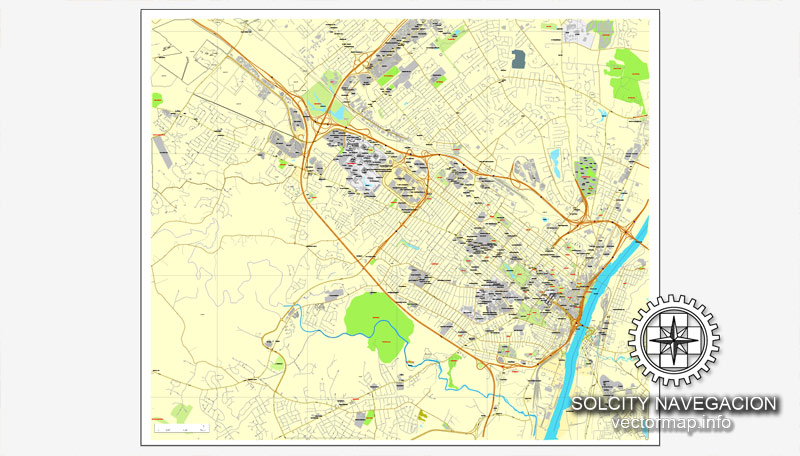
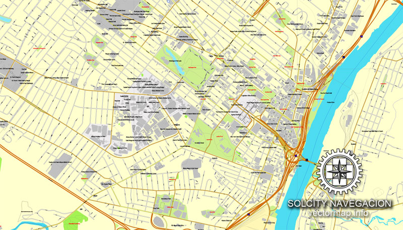
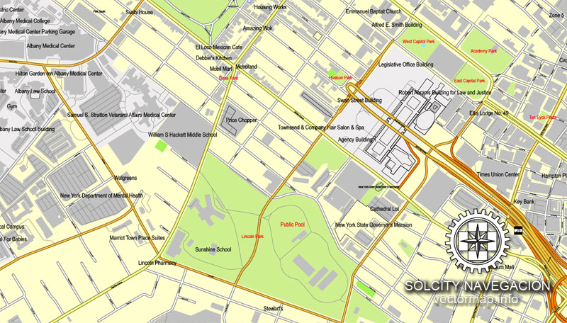
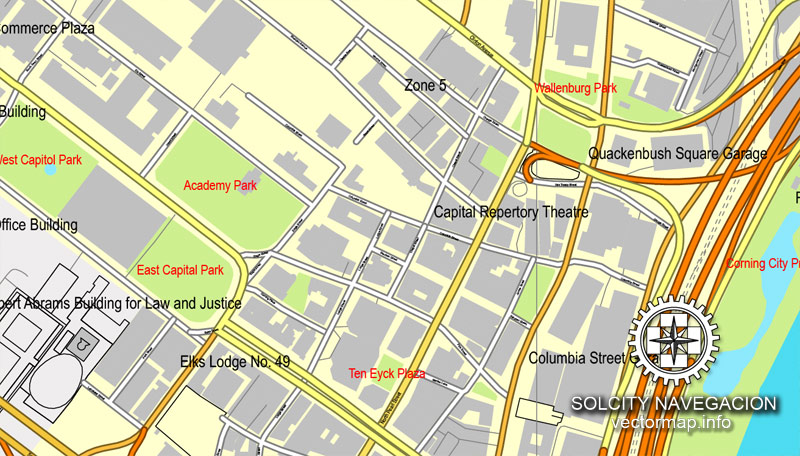
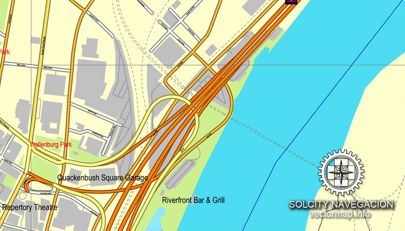
This vector map of Albany city is used as a basis for design, editing, and further printing.
This is the most detailed, exact map of Albany city for high-quality printing and polygraphy. You can always clarify the map development date by contacting us.
For your convenience, all objects on Albany vector city map are divided into layers. And the editing is very easy – colors, lines, etc.
Albany is the capital of the U.S. state of New York and the seat of Albany County. Albany is located on the west bank of the Hudson River approximately 10 miles (16 km) south of its confluence with the Mohawk River and approximately 150 miles (240 km) north of New York City.
One of the advantages of Albany city vector maps of our production is the relevance of cartographic data, we constantly update all our products.
This vector map of Albany city is used by:
designers, layout designers, printers, advertisers and architects. Our product – vector maps – is designed for further editing and printing in large formats – from @Wall format (a few meters) to A-0 and A-1, A-2, A-3.
The advertising and presentation map of Albany city (usually the final designer marks the routes, and puts the client’s objects (shops, saloons, gas stations etc.)
The undoubted advantage is that people will NEVER throw out this advertising product – the map. In fact, as an advertising medium, a city map is the most “long-playing” of the well-known polygraphic advertising media, with the longest lifespan, and the maximum number of interactions with the customer.
Albany is known for its rich history, commerce, culture, architecture, and institutions of higher education. Albany constitutes the economic and cultural core of the Capital District of New York State, which comprises the Albany-Schenectady-Troy, NY Metropolitan Statistical Area, including the nearby cities and suburbs of Troy, Schenectady, and Saratoga Springs. With a 2013 Census-estimated population of 1.1 million the Capital District is the third-most populous metropolitan region in the state. As of the 2010 census, the population of Albany was 97,856.
For travelers, maps are sold at the airports and gas stations around the world. Often the source is our vector maps.
Take a look, who purchases our vector maps of Albany city in “Our Clients and Friends” page – these are large and small companies, from super-brands like Volvo and Starbucks, to small design studios and printing houses.
It’s very easy to work with vector maps of Albany city, even for a not very experienced designer who can turn on and off the map layers, add new objects, change the colors of fill and lines according to customer requirements.
The undoubted advantage of Albany city vector maps in printing is an excellent and detailed visualization, when customer can expand a large paper map and instantly define his location, find a landmark, an object or address on map, unlike using the popular electronic formats of Google and Yandex maps for example.
The area that later became Albany was settled by Dutch colonists who in 1614, built Fort Nassau for fur trading and, in 1624, built Fort Orange. In 1664, the English took over the Dutch settlements, renaming the city as Albany, in honor of the then Duke of Albany, the future James II of England and James VII of Scotland. The city was officially chartered in 1686 under English rule. It became the capital of New York in 1797 following formation of the United States. Albany is one of the oldest surviving settlements of the original British thirteen colonies, and is the longest continuously chartered city in the United States.
Printable vector maps of Albany city are much more convenient and efficient than any electronic maps on your smartphone, because ALL DETAILS are displayed in the entire space of Albany city map.
Useful tips on working with vector maps of cities and countries in Adobe Illustrator.
«V» – launches the Selection tool (cursor, black arrow), which makes active any vector line.
«А» – launches the Direct Selection tool (white cursor), allows you to select curve elements and drag them to the desired place.
«R» – activates the Rotate tool, which helps you rotating selected objects around the center point by 360 degrees.
«E» – gives you the opportunity to use the Eraser tool and erase unnecessary parts.
«X» – switches between Fill and Stroke in the Tools section. Try to get used to this hot key and
you will quickly understand that you can’t live and work without it.
During the late 18th century and throughout most of the 19th, Albany was a center of trade and transportation. The city lies toward the north end of the navigable Hudson River, was the original eastern terminus of the Erie Canal connecting to the Great Lakes, and was home to some of the earliest railroad systems in the world. In the 1920s, a powerful political machine controlled by the Democratic Party arose in Albany.
Guides are not limited to vertical and horizontal in Adobe Illustrator. You can also create a diagonal guide for example. Moreover, you can turn any contours into guides. Select the outline and go to View > Guides > Make Guides (Create Guides), or simply press Cmd/Ctrl + 5. You can also turn the guides back into an editable object. Go to menu, View > Guides > Unlock Guides (Release Guides), select the guide you want to edit and select View > Guides > Release Guides (Reset Guides), or just press Cmd/Ctrl + Option / Alt + 5).
You will probably want to change the color scheme used on our Albany vector city map.
In the latter part of the 20th century, Albany experienced a decline in its population due to urban sprawl and suburbanization; however, the New York State Legislature approved a $234 million building and renovation plan for the City in the 1990s that spurred renovation and building projects around the downtown area. In the early 21st century, Albany has experienced growth in the high-technology industry, with great strides in the nanotechnology sector.
To quickly and effectively play with colors.
Of course, you can do it manually, all objects in our Albany city vector map are divided according to types and layers, and you can easily change the color gamma of vector objects in groups and layers.
But there is more effective way of working with the whole VECTOR MAP of Albany city and all layers:
The overview dialog «Edit colors»/«Repaint Graphic Object» (this dialog box name can change depending on the context):
If you have selected a part or a layer of Albany city vector map and open the dialog box by clicking the icon in the Control panel, on the Samples palette or the Color Catalog, or if you choose Edit > Edit Colors> Repaint Graphic Object, then the «Repaint Graphic Object» dialog box appears, and you get access to «Assign» and «Edit» tabs.
If a picture or a map fragment is not selected, and you open the dialog box by clicking the icon in the Control panel, on the Samples palette or in the Color Catalog, the «Edit Colors» dialog box appears and you can only access the «Edit» tab.
Geography
Albany is about 150 miles (240 km) north of New York City on the Hudson River. It has a total area of 21.8 square miles (56 km2), of which 21.4 square miles (55 km2) is land and 0.4 square miles (1.0 km2) (1.8%) is water. The city is bordered on the north by the town of Colonie (along with the village of Menands), on the west by the town of Guilderland, and on the south by the town of Bethlehem. The Hudson River represents the city’s eastern border.
Regardless of the name at the top of the dialog box, the right-hand side always displays the color group of the current document, as well as two default color groups: Print Color and Grayscale. These color groups can be selected and used any time.
Create and edit color groups of Albany city vector map, and also assign colors using the «Edit Colors»/ а «Repaint Graphic Object» dialog box.
A. Creating and editing of a color group on the «Edit» tab
B. Assigning colors on the «Assign» tab
C. Select a group of colors from the «Color groups» list
The option «Repaint a graphic object» in the lower part of the dialog box allows you to preview the colors on a selected layer of Vector map, or a group of elements, and specify whether its colors will be redefined when the dialog box is closed.
The main areas of the dialog box are:
«Edit»
The «Edit» tab is designed to create a new or edit the existing color groups.
The harmony rules Menu and the Color Wheel are used to conduct experiments with color harmonies. The color wheel shows how colors are related in color harmony, and the color bars allow you to view and manipulate an individual color values. In addition, you can adjust the brightness, add and remove colors, save color groups and view colors on the selected Vector Map of Albany city or a separated layers.
Patroon Creek, along the northern border, and the Normans Kill, along the southern border, are the two major streams in the city. The former Foxes Creek, Beaver Kill, and Rutten Kill still exist, but were diverted underground in the 19th century. There are four lakes within city limits: Buckingham Lake; Rensselaer Lake at the mouth of the Patroon Creek; Tivoli Lake, which was formed as a reservoir and once connected to the Patroon Creek; and Washington Park Lake, which was formed by damming the Beaver Kill.
A few pine trees are surrounded by a number of low-lying oak-scrub bushes and trees during summer months.
The Albany Pine Bush is the only sizable inland pine barrens sand dune ecosystem in the United States.
«Assign»
The «Assign» tab is used to view and control on how the original colors are replaced with colors from the color group like your corporate colors in the Vector Map of Albany city.
The assign color ability is provided only if the entire map, layer or fragment is selected in the document. You can specify which of new colors replace the current colors, whether the spot colors should be preserved and how colors are replaced (for example, you can replace colors completely or changing the color tone while maintaining the brightness). The «Assign» tab allows you to redefine colors in the Vector Map of Albany city, or in separate layers and fragments using the current color group or reducing the number of colors in the current Vector Map.
Color groups
Is a list of all saved color groups for current document (the same groups appear in the «Samples» palette). You can edit and delete the existing color groups, as well as creating a new ones using the list of “Color Groups” in the dialog box. All changes appear in the «Samples» palette.
The highlighted color group shows, which color group is currently edited.
Any color group can be selected and edited, or used to redefine the colors in the selected vector map of Albany city, its fragments or elements.
Saving a color group adds this group to the specified list.
Opening the «Edit Colors»/«Repaint Graphic Object» dialog box.
Open the «Edit Colors»/«Repaint Graphic Object» dialog box using one of the following methods:
«Edit»> «Edit Colors»> «Repaint Graphic object» or «Repaint With Style».
Use these commands if you need to edit the colors in the selected vector map of Albany city.
«Repaint Graphic object» button on the «Control» panel.
Use this button if you need to adjust colors of Albany city vector map using the а «Repaint graphic object» dialog box.
The specified button is available if the selected vector map or its fragment contains two or more colors.
Note. This color editing method is convenient for global color adjustment in a vector map, if global colors were not used when creating a City Map of Albany.
The «Edit colors» button or «Edit or apply colors» on the «Color Catalog» palette
Click this button if you need to edit colors on the «Color Catalog» palette or edit and then apply them to the selected Vector Map of Albany city or its fragment.
The «Edit color group» button or «Edit or apply color group» on the «Samples» palette.
Click this button if you need to edit the colors in the specific color group or edit and apply them to the selected Vector Map of Albany city or a group of its elements, for example, the whole layer “Streets and lines”. You can also double-click the color group in the Samples panel to open the dialog box.
If the map file is too large and your computer freezes or even can’t open it quickly:
1. Try to reduce the color resolution of the video card (display) to 256 colors while working with a large map.
2. Using Windows Task Manager, select all the application you don’t need, while working with map, just turn them off.
3. Launch Adobe Illustrator. (DO NOT OPEN the vector map file)
4. Start the Windows Task Manager using administrator rights > Find the “Illustrator” process > set the «real time» priority,
5. Open the file. When you see the LEGACY FONT popup window – click “OK” (do not update). You can restore the TEXT later.
6. Can also be useful: When file is opened – Edit > Settings > Basic Settings > disable smoothing. /// It looks scary, but works quickly)))
We recommend saving the file in Adobe Illustrator 10 version. It’s much more stable when working with VERY BIG size files.
The highest natural point in Albany is a USGS benchmark near the Loudonville Reservoir off Birch Hill Road, at 378 feet (115 m) above sea level. The lowest point is sea level at the Hudson River (the average water elevation is 2 feet (0.61 m)), which is still technically an estuary at Albany and is affected by the Atlantic tide. The interior of Albany consists of rolling hills which were once part of the Albany Pine Bush, an area of pitch pine and scrub oak, and has arid, sandy soil that is a remnant of the ancient Lake Albany. Due to development, the Pine Bush has shrunk from an original 25,000 to 6,000 acres (10,100 to 2,400 ha) today. A preserve was set up by the State Legislature in 1988 and is on the city’s western edge, spilling into Guilderland and Colonie; it is the only sizable inland pine barrens sand dune ecosystem in the United States, and is home to many endangered species, including the Karner Blue butterfly.
Neighborhoods
The neighborhoods of Albany are varied demographically, geographically, architecturally, and historically. Downtown Albany is the city’s oldest neighborhood, centered on State Street, one of Albany’s oldest streets and its original main street. North and south of Downtown Albany are old residential communities often consisting of row houses; to the north, those neighborhoods include Sheridan Hollow, Arbor Hill, and North Albany, while to the south is the super-neighborhood of the South End, which includes several smaller neighborhoods.
West of Downtown Albany is the Empire State Plaza, which effectively cuts Downtown off from the gentrified neighborhoods of Center Square and Hudson/Park. Single-family detached homes, duplexes, and apartments, along with single-family houses that have been divided into multiple units, can be found west of the older neighborhoods. These neighborhoods, such as Pine Hills, Delaware Avenue, Whitehall, Helderberg, and New Scotland/Woodlawn, tend to have larger lots and more suburban surroundings than the neighborhoods nearer to the Hudson River. Further west, the neighborhoods become more affluent and are dominated almost exclusively by single-family dwellings. The western portion of the City includes the W. Averell Harriman State Office Building Campus and the University at Albany’s main campus, as well as offices and commercial properties lining frontage roads along Washington Avenue Extension.
Parks and recreation
An orange-red mission-style building is seen on the banks of a lake, surrounded by trees.
The 1929 Washington Park Lake House replaced a wooden lake house built in 1876.
Albany has more than 60 public parks and recreation areas. Washington Park was organized as the Middle Public Square in 1806. Its current location has been public property since the Dongan Charter of 1686 gave the city title to all property not privately owned. Washington Park was designed by John Bogart and John Cuyler in 1870, and opened for public use the following year. The original lake house, designed by Frederick W. Brown, was added in 1876. The park had previously been used as a cemetery; its graves were moved to Albany Rural Cemetery. Washington Park is a popular place to exercise and play sports; skate during the winter; people-watch during Tulip Fest; and attend plays at the amphitheater during the summer.
A green space with trees and rolling lawns is flanked by tall, modern-style buildings in the background on a sunny day.
Lincoln Park is flanked on the north by the Empire State Plaza.
Other parks in Albany include Lincoln Park, Buckingham Park, the Corning Preserve, and the Pine Bush. Lincoln Park, southwest of the Empire State Plaza, was organized in 1886 and was originally known as Beaver Park. Today, the park has a pool that is open during the summer months. Buckingham Lake Park is between Manning Boulevard and Route 85 in the Buckingham Pond neighborhood; it contains a pond with fountains, a footpath, a playground, and picnic tables. The Albany Riverfront Park at the Corning Preserve has an 800-seat amphitheatre that hosts events in non-winter months, most notably the Alive at 5 summer concert series. The Preserve’s visitors center details the ecology of the Hudson River and the local environment. The park has a bike trail and boat launch and was effectively separated from downtown by Interstate 787 until the opening of the Hudson River Way in 2002.
Other public parks include Westland Hill Park, Hoffman Park, Beverwyck Park, and Liberty Park, today a small circular grassy patch in downtown on Hudson Avenue, which is Albany’s oldest park. Ridgefield Park is home to the clay courts of the Albany Tennis Club, one of the oldest tennis clubs in the United States. The municipal golf course, New Course at Albany, was constructed in 1929 as the Albany Municipal Golf Course, later renamed the Capital Hills at Albany, and remodeled in 1991.
Small guide: How to work with the vector map?
You can: Mass select objects by type and color – for example, the objects type “building” (they are usually dark gray) – and remove them from the map, if you do not need them in your print or design project. You can also easily change the thickness of lines (streets), just bulk selection the road by the line color.
The streets are separated by type, for example, type “residential road” are usually white with a gray stroke. Highway usually orange with a brown or dark gray stroke.
It is easy to change the font of inscriptions, all or each individually. Also, just can be make and any other manipulation of objects on the vector map in Adobe illustrator format.
Important: All the proportions on the map are true, that is, the relative sizes of the objects are true, because Map is based on an accurate GPS projection, and It transated into the (usual for all) the Mercator projection.
You can easily change the color, stroke and fill of any object on the map, zoom without loss of quality Image Verification.
Select object

Bulk selection the same objects on the vector map

See the bulk selected objects on the vector map

Bulk delete buildungs from the vector map

Select residencial road (small street) on the vector map

Bulk selection the same lines (streets, roads) on the full map

Create fat lines of the streets on the vector maps (bulk action) 1

Create fat lines of the streets on the vector maps (bulk action) 2

Create fat lines of the streets on the vector maps (bulk action) 3

You can easily change the color, stroke and fill of any object on the map, zoom without loss of quality Image Verification.

 Author: Kirill Shrayber, Ph.D. FRGS


