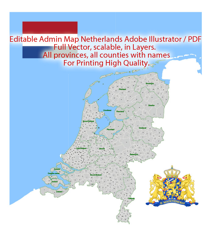
Netherlands Map Administrative Vector Adobe Illustrator Editable PDF Provinces Counties for publishing, design, media, projects, presentations, for High Quality Printing
Layers: Provinces, Counties, Borders_provinces, Borders_counties, Names_provinces, Names_counties, Flag, sea.
Text format all names
Netherlands.
This vector map of Netherlands is used as a basis for design, editing, and further printing.
This is the most detailed, exact map of Netherlands for high-quality printing and polygraphy. You can always clarify the map development date by contacting us.
For your convenience, all objects on Netherlands vector map are divided into layers. And the editing is very easy – colors, lines, etc.
You can easily add any objects needed (e.g. shops, salons, sale points, gas station or attraction) on any layer of Netherlands vector map.
The Netherlands is a country located mainly in Northwestern Europe. Together with three island territories in the Caribbean (Bonaire, Sint Eustatius and Saba), it forms a constituent country of the Kingdom of the Netherlands. The European portion of the Netherlands consists of twelve provinces and borders Germany to the east, Belgium to the south, and the North Sea to the northwest, sharing maritime borders in the North Sea with Belgium, the United Kingdom, and Germany.
One of the advantages of Netherlands vector maps of our production is the relevance of cartographic data, we constantly update all our products.
This vector map of Netherlands is used by:
designers, layout designers, printers, advertisers and architects. Our product – vector maps – is designed for further editing and printing in large formats – from @Wall format (a few meters) to A-0 and A-1, A-2, A-3.
The Netherlands map in vector format is used for design, urban planning, presentations and media visualizations.
The advertising and presentation map of Netherlands (usually the final designer marks the routes, and puts the client’s objects (shops, saloons, gas stations etc.)
The undoubted advantage is that people will NEVER throw out this advertising product – the map. In fact, as an advertising medium, a map is the most “long-playing” of the well-known polygraphic advertising media, with the longest lifespan, and the maximum number of interactions with the customer.
For travelers, maps are sold at the airports and gas stations around the world. Often the source is our vector maps.
Take a look, who purchases our vector maps of Netherlands in “Our Clients and Friends” page – these are large and small companies, from super-brands like Volvo and Starbucks, to small design studios and printing houses.
It’s very easy to work with vector maps of Netherlands city, even for a not very experienced designer who can turn on and off the map layers, add new objects, change the colors of fill and lines according to customer requirements.
The undoubted advantage of Netherlands vector maps in printing is an excellent and detailed visualization, when customer can expand a large paper map and instantly define his location, find a landmark, an object or address on map, unlike using the popular electronic formats of Google and Yandex maps for example.
Printable vector maps of Netherlands are much more convenient and efficient than any electronic maps on your smartphone, because ALL DETAILS are displayed in the entire space of Netherlands map.
Useful tips on working with vector maps of cities and countries in Adobe Illustrator.
«V» – launches the Selection tool (cursor, black arrow), which makes active any vector line.
«А» – launches the Direct Selection tool (white cursor), allows you to select curve elements and drag them to the desired place.
«R» – activates the Rotate tool, which helps you rotating selected objects around the center point by 360 degrees.
«E» – gives you the opportunity to use the Eraser tool and erase unnecessary parts.
«X» – switches between Fill and Stroke in the Tools section. Try to get used to this hot key and
you will quickly understand that you can’t live and work without it.
The five largest cities in the Netherlands are Amsterdam, Rotterdam, The Hague, Utrecht (forming the Randstad megalopolis) and Eindhoven (leading the Brabantse Stedenrij). Amsterdam is the country’s capital, while The Hague holds the seat of the States General, Cabinet and Supreme Court. The Port of Rotterdam is the largest port in Europe and the world’s largest outside Asia.
Guides are not limited to vertical and horizontal in Adobe Illustrator. You can also create a diagonal guide for example. Moreover, you can turn any contours into guides. Select the outline and go to View > Guides > Make Guides (Create Guides), or simply press Cmd/Ctrl + 5. You can also turn the guides back into an editable object. Go to menu, View > Guides > Unlock Guides (Release Guides), select the guide you want to edit and select View > Guides > Release Guides (Reset Guides), or just press Cmd/Ctrl + Option / Alt + 5).
You will probably want to change the color scheme used on our Netherlands vector map.
‘Netherlands’ literally means ‘lower countries’, referring to its low land and flat geography, with only about 50% of its land exceeding 1 metre (3 ft 3 in) above sea level. Most of the areas below sea level are the result of land reclamation beginning in the 16th century, resulting in large areas known as polders that amount to nearly 17% of the country’s territory. With a population of 17.25 million living within a total area of roughly 41,500 square kilometres (16,000 sq mi), of which the land area is 33,700 square kilometres (13,000 sq mi), the Netherlands is one of the most densely populated countries in the world. Nevertheless, it is the world’s second-largest exporter of food and agricultural products after the United States, owing to its fertile soil, mild climate, and intensive agriculture.
To quickly and effectively play with colors.
Of course, you can do it manually, all objects in our Netherlands vector map are divided according to types and layers, and you can easily change the color gamma of vector objects in groups and layers.
But there is more effective way of working with the whole VECTOR MAP of Netherlands and all layers:
The overview dialog «Edit colors»/«Repaint Graphic Object» (this dialog box name can change depending on the context):
If you have selected a part or a layer of Netherlands vector map and open the dialog box by clicking the icon in the Control panel, on the Samples palette or the Color Catalog, or if you choose Edit > Edit Colors> Repaint Graphic Object, then the «Repaint Graphic Object» dialog box appears, and you get access to «Assign» and «Edit» tabs.
If a picture or a map fragment is not selected, and you open the dialog box by clicking the icon in the Control panel, on the Samples palette or in the Color Catalog, the «Edit Colors» dialog box appears and you can only access the «Edit» tab.
The Netherlands was the third country in the world to have representative government, and has been administered as a parliamentary constitutional monarchy since 1848, with a unitary structure. A policy of pillarisation historically segregated society and institutions between Catholics, Calvinists and socialists, but Dutch society is today one of the most cosmopolitan in the world. The country has a long history of social tolerance and is generally regarded as a liberal country, having legalised abortion, prostitution, and euthanasia, while maintaining a progressive drug policy. The Netherlands abolished the death penalty in 1870, allowed women’s suffrage in 1917, and became the world’s first country to legalise same-sex marriage in 2001.
Regardless of the name at the top of the dialog box, the right-hand side always displays the color group of the current document, as well as two default color groups: Print Color and Grayscale. These color groups can be selected and used any time.
Create and edit color groups of Netherlands vector map, and also assign colors using the «Edit Colors»/ а «Repaint Graphic Object» dialog box.
A. Creating and editing of a color group on the «Edit» tab
B. Assigning colors on the «Assign» tab
C. Select a group of colors from the «Color groups» list
The option «Repaint a graphic object» in the lower part of the dialog box allows you to preview the colors on a selected layer of Vector map, or a group of elements, and specify whether its colors will be redefined when the dialog box is closed.
The Netherlands is a founding member of the EU, Eurozone, G10, NATO, OECD, and WTO, as well as a part of the Schengen Area and the trilateral Benelux Union. It hosts several intergovernmental organizations and international courts, many of which are centered in The Hague, which is consequently dubbed ‘the world’s legal capital.’ Its mixed-market advanced economy had the thirteenth-highest per capita income globally. One of the world’s most prosperous countries, the Netherlands ranks among the highest in international indexes of press freedom, economic freedom, human development, and quality of life. Its strong performance is owed in large part to a generous welfare state that provides universal healthcare, public education and infrastructure, and a range of social benefits. It is also known for its polder model, the country’s leading socioeconomic model based on consensus decision-making.
The main areas of the dialog box are:
«Edit»
The «Edit» tab is designed to create a new or edit the existing color groups.
The harmony rules Menu and the Color Wheel are used to conduct experiments with color harmonies. The color wheel shows how colors are related in color harmony, and the color bars allow you to view and manipulate an individual color values. In addition, you can adjust the brightness, add and remove colors, save color groups and view colors on the selected Vector Map of Netherlands or a separated layers.
«Assign»
The «Assign» tab is used to view and control on how the original colors are replaced with colors from the color group like your corporate colors in the Vector Map of Netherlands city.
The assign color ability is provided only if the entire map, layer or fragment is selected in the document. You can specify which of new colors replace the current colors, whether the spot colors should be preserved and how colors are replaced (for example, you can replace colors completely or changing the color tone while maintaining the brightness). The «Assign» tab allows you to redefine colors in the Vector Map of Netherlands city, or in separate layers and fragments using the current color group or reducing the number of colors in the current Vector Map.
Color groups
Is a list of all saved color groups for current document (the same groups appear in the «Samples» palette). You can edit and delete the existing color groups, as well as creating a new ones using the list of “Color Groups” in the dialog box. All changes appear in the «Samples» palette.
The highlighted color group shows, which color group is currently edited.
Any color group can be selected and edited, or used to redefine the colors in the selected vector map of Netherlands city, its fragments or elements.
Saving a color group adds this group to the specified list.
Opening the «Edit Colors»/«Repaint Graphic Object» dialog box.
Open the «Edit Colors»/«Repaint Graphic Object» dialog box using one of the following methods:
«Edit»> «Edit Colors»> «Repaint Graphic object» or «Repaint With Style».
Use these commands if you need to edit the colors in the selected vector map of Netherlands city.
«Repaint Graphic object» button on the «Control» panel.
Use this button if you need to adjust colors of Netherlands vector map using the а «Repaint graphic object» dialog box.
The specified button is available if the selected vector map or its fragment contains two or more colors.
Note. This color editing method is convenient for global color adjustment in a vector map, if global colors were not used when creating a Map of Netherlands.
The «Edit colors» button or «Edit or apply colors» on the «Color Catalog» palette
Click this button if you need to edit colors on the «Color Catalog» palette or edit and then apply them to the selected Vector Map of Netherlands or its fragment.
The «Edit color group» button or «Edit or apply color group» on the «Samples» palette.
Click this button if you need to edit the colors in the specific color group or edit and apply them to the selected Vector Map of Netherlands or a group of its elements, for example, the whole layer “Streets and lines”. You can also double-click the color group in the Samples panel to open the dialog box.
If the map file is too large and your computer freezes or even can’t open it quickly:
1. Try to reduce the color resolution of the video card (display) to 256 colors while working with a large map.
2. Using Windows Task Manager, select all the application you don’t need, while working with map, just turn them off.
3. Launch Adobe Illustrator. (DO NOT OPEN the vector map file)
4. Start the Windows Task Manager using administrator rights > Find the “Illustrator” process > set the «real time» priority,
5. Open the file. When you see the LEGACY FONT popup window – click “OK” (do not update). You can restore the TEXT later.
6. Can also be useful: When file is opened – Edit > Settings > Basic Settings > disable smoothing. /// It looks scary, but works quickly)))
We recommend saving the file in Adobe Illustrator 10 version. It’s much more stable when working with VERY BIG size files.
Geography
According to the Central Bureau of Statistics, the European Netherlands has a total land area of 41,528 km2, including non-tidal water bodies. It lies between latitudes 50° and 54° N, and longitudes 3° and 8° E.
The Netherlands is geographically a very low and flat country, with about 26% of its area and 21% of its population located below sea level, and only about 50% of its land exceeding one metre above sea level. The European part of the country is for the most part flat, with the exception of foothills in the far southeast, up to a height of no more than 321 metres, and some low hill ranges in the central parts. Most of the areas below sea level are man-made, caused by peat extraction or achieved through land reclamation. Since the late 16th century, large polder areas are preserved through elaborate drainage systems that include dikes, canals and pumping stations. Nearly 17% of the country’s land area is reclaimed from the sea and from lakes.
Much of the country was originally formed by the estuaries of three large European rivers: the Rhine (Rijn), the Meuse (Maas) and the Scheldt (Schelde), as well as their tributaries. The south-western part of the Netherlands is to this day a river delta of these three rivers, the Rhine-Meuse-Scheldt delta.
The European Netherlands is divided into north and south parts by the Rhine, the Waal, its main tributary branch, and the Meuse. In the past these rivers functioned as a natural barrier between fiefdoms and hence historically created a cultural divide, as is evident in some phonetic traits that are recognisable on either side of what the Dutch call their “Great Rivers” (de Grote Rivieren). Another significant branch of the Rhine, the IJssel river, discharges into Lake IJssel, the former Zuiderzee (‘southern sea’). Just like the previous, this river forms a linguistic divide: people to the northeast of this river speak Dutch Low Saxon dialects (except for the province of Friesland, which has its own language).
The geography of the Netherlands in Europe is unusual in that much of its land has been reclaimed from the sea and is below sea level, protected by dikes. Another factor that has influenced its physical appearance is that the country is among the most densely populated on Earth. It is ranked 30th overall on that scale, but is behind only three countries having a population over 16 million. Consequently, the Netherlands is highly urbanized.
Landscape
The European part of the country can be split into two areas: the low and flat lands in the west and north, and the higher lands with minor hills in the east and south. The former, including the reclaimed polders and river deltas, make up about half of its surface area and are less than 1 metre (3.3 ft) above sea level, much of it actually below sea level. An extensive range of seawalls and coastal dunes protect the Netherlands from the sea, and levees and dikes along the rivers protect against river flooding. The rest of the country is mostly flat; only in the extreme south of the country does the land rise to any significant extent, in the foothills of the Ardennes mountains. This is where Vaalserberg is located, the highest point on the European part of the Netherlands at 322.7 metres (1,059 ft) above sea level. The highest point of the entire country is Mount Scenery (887 metres or 2,910 ft), which is located outside the European part of the Netherlands, on the island of Saba. The Netherlands is located at mouths of three major European rivers (Rhine, Maas or Meuse, and Scheldt).
In November 2016, the Netherlands and Belgium agreed to cede small, uninhabited parcels of land to reflect a change in course of the river Meuse (or Maas, in Dutch). The land swap is to take effect as of 2018.
Netherlands
Country in Europe
The Netherlands, a country in northwestern Europe, is known for a flat landscape of canals, tulip fields, windmills and cycling routes. Amsterdam, the capital, is home to the Rijksmuseum, Van Gogh Museum and the house where Jewish diarist Anne Frank hid during WWII. Canalside mansions and a trove of works from artists including Rembrandt and Vermeer remain from the city’s 17th-century “Golden Age.”
Capital: Amsterdam
Dialing code: +31
Official regional languages: West Frisian; Papiamento; English;
Sovereign state: Kingdom of the Netherlands
Official languages: Dutch, English, Papiamento, Frisian
Netherlands has the fifth-largest net exports (92,500 billions US$) in the world
Area
• Total 41,543 km2 (16,040 sq mi)
• Water (%) 18.41
Population
• 2018 estimate 17,200,671
• Density 414.5/km2 (1,073.6/sq mi)

 Author: Kirill Shrayber, Ph.D. FRGS

