Nantes, France printable vector street City Plan map, full editable, Adobe Illustrator, full vector, scalable, editable, text format street names, 20,2 mb ZIP
All streets, All buildings. Map for design, print, arts, projects, presentations,
for architects, designers and builders.
PDF, DXF, DWG, CDR and other formats – on request, same price, please, contact
Nantes, France rue vecteur imprimable Plan Plan de ville, plein modifiable, Adobe Illustrator, vectoriel complet,,, noms évolutives rue format texte modifiable, 20,2 mb ZIP
Toutes les rues, tous les bâtiments. Carte de conception, d’impression, des arts, des projets, des présentations,
pour les architectes, les concepteurs et les constructeurs.
PDF, DXF, DWG, CDR et d’autres formats – sur demande, même prix, s’il vous plaît, contactez
Nantes, France.
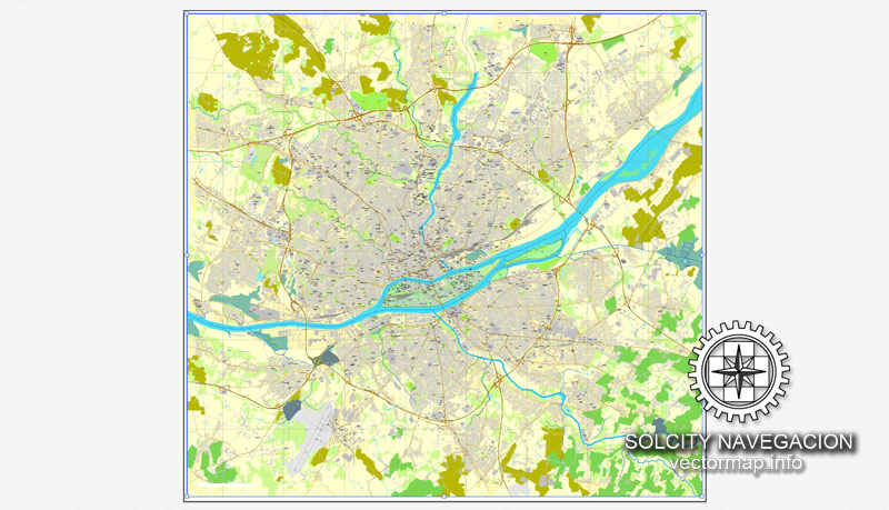
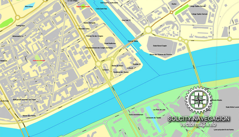
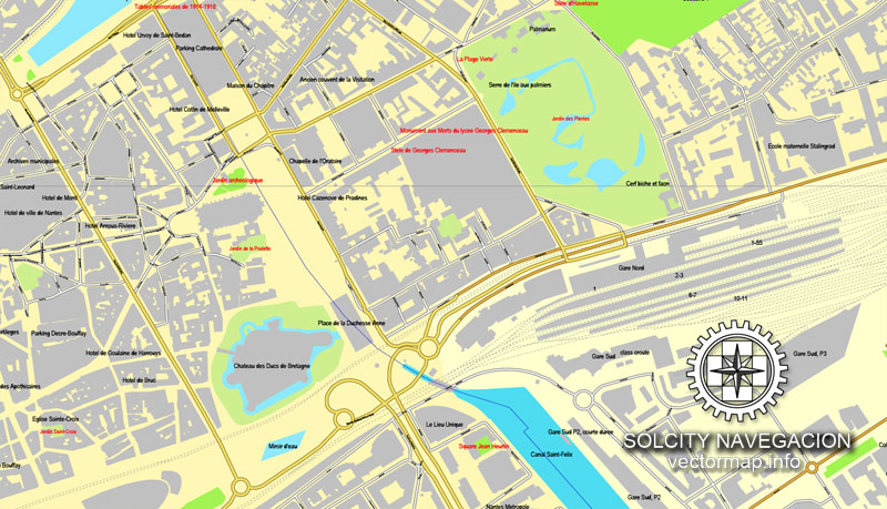
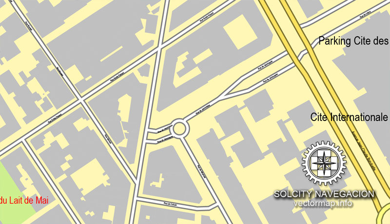
This vector map of Nantes is used as a basis for design, editing, and further printing.
This is the most detailed, exact map of Nantes for high-quality printing and polygraphy. You can always clarify the map development date by contacting us.
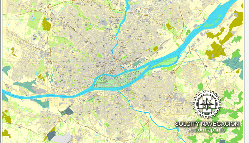
For your convenience, all objects on Nantes vector map are divided into layers. And the editing is very easy – colors, lines, etc.
You can easily add any objects needed (e.g. shops, salons, sale points, gas station or attraction) on any layer of Nantes vector map.
Nantes is a city in Loire-Atlantique on the Loire, 50 km (31 mi) from the Atlantic coast. The city is the sixth-largest in France, with a population of 303,382 in Nantes and a metropolitan area of nearly 950,000 inhabitants. With Saint-Nazaire, a seaport on the Loire estuary, Nantes forms the main north-western French metropolis.
One of the advantages of Nantes vector maps of our production is the relevance of cartographic data, we constantly update all our products.
This vector map of Nantes is used by:
designers, layout designers, printers, advertisers and architects. Our product – vector maps – is designed for further editing and printing in large formats – from @Wall format (a few meters) to A-0 and A-1, A-2, A-3.
Nantes map in vector format is used for design, urban planning, presentations and media visualizations.
Advertising and presentation map of Nantes (usually the final designer marks the routes, and puts the client’s objects (shops, saloons, gas stations etc.)
The undoubted advantage is that people will NEVER throw out this advertising product – the map. In fact, as an advertising medium, a map is the most “long-playing” of the well-known polygraphic advertising media, with the longest lifespan, and the maximum number of interactions with the customer.
For travelers, maps are sold at the airports and gas stations around the world. Often the source is our vector maps.
Take a look, who purchases our vector maps of Nantes in “Our Clients and Friends” page – these are large and small companies, from super-brands like Volvo and Starbucks, to small design studios and printing houses.
It’s very easy to work with vector maps of Nantes, even for a not very experienced designer who can turn on and off the map layers, add new objects, change the colors of fill and lines according to customer requirements.
The undoubted advantage of Nantes vector maps in printing is an excellent and detailed visualization, when customer can expand a large paper map and instantly define his location, find a landmark, an object or address on map, unlike using the popular electronic formats of Google and Yandex maps for example.
Printable vector maps of Nantes are much more convenient and efficient than any electronic maps on your smartphone, because ALL DETAILS are displayed in the entire space of Nantes map.
Useful tips on working with vector maps of cities and countries in Adobe Illustrator.
«V» – launches the Selection tool (cursor, black arrow), which makes active any vector line.
«А» – launches the Direct Selection tool (white cursor), allows you to select curve elements and drag them to the desired place.
«R» – activates the Rotate tool, which helps you rotating selected objects around the center point by 360 degrees.
«E» – gives you the opportunity to use the Eraser tool and erase unnecessary parts.
«X» – switches between Fill and Stroke in the Tools section. Try to get used to this hot key and
you will quickly understand that you can’t live and work without it.
Guides are not limited to vertical and horizontal in Adobe Illustrator. You can also create a diagonal guide for example. Moreover, you can turn any contours into guides. Select the outline and go to View > Guides > Make Guides (Create Guides), or simply press Cmd/Ctrl + 5. You can also turn the guides back into an editable object. Go to menu, View > Guides > Unlock Guides (Release Guides), select the guide you want to edit and select View > Guides > Release Guides (Reset Guides), or just press Cmd/Ctrl + Option / Alt + 5).
You will probably want to change the color scheme used on our Nantes vector map.
To quickly and effectively play with colors.
Of course, you can do it manually, all objects in our Nantes vector map are divided according to types and layers, and you can easily change the color gamma of vector objects in groups and layers.
But there is more effective way of working with the whole VECTOR MAP of Nantes and all layers:
The overview dialog «Edit colors»/«Repaint Graphic Object» (this dialog box name can change depending on the context):
If you have selected a part or a layer of Nantes vector map and open the dialog box by clicking the icon in the Control panel, on the Samples palette or the Color Catalog, or if you choose Edit > Edit Colors> Repaint Graphic Object, then the «Repaint Graphic Object» dialog box appears, and you get access to «Assign» and «Edit» tabs.
If a picture or a map fragment is not selected, and you open the dialog box by clicking the icon in the Control panel, on the Samples palette or in the Color Catalog, the «Edit Colors» dialog box appears and you can only access the «Edit» tab.
Regardless of the name at the top of the dialog box, the right-hand side always displays the color group of the current document, as well as two default color groups: Print Color and Grayscale. These color groups can be selected and used any time.
It is the administrative seat of the Loire-Atlantique department and the Pays de la Loire région, one of 18 regions of France. Nantes belongs historically and culturally to Brittany, a former duchy and province, and its omission from the modern administrative region of Brittany is controversial.
Create and edit color groups of Nantes vector map, and also assign colors using the «Edit Colors»/ а «Repaint Graphic Object» dialog box.
A. Creating and editing of a color group on the «Edit» tab
B. Assigning colors on the «Assign» tab
C. Select a group of colors from the «Color groups» list
The option «Repaint a graphic object» in the lower part of the dialog box allows you to preview the colors on a selected layer of Vector map, or a group of elements, and specify whether its colors will be redefined when the dialog box is closed.
The main areas of the dialog box are:
«Edit»
The «Edit» tab is designed to create a new or edit the existing color groups.
The harmony rules Menu and the Color Wheel are used to conduct experiments with color harmonies. The color wheel shows how colors are related in color harmony, and the color bars allow you to view and manipulate an individual color values. In addition, you can adjust the brightness, add and remove colors, save color groups and view colors on the selected Vector Map of Nantes or a separated layers.
«Assign»
The «Assign» tab is used to view and control on how the original colors are replaced with colors from the color group like your corporate colors in the Vector Map of Nantes.
The assign color ability is provided only if the entire map, layer or fragment is selected in the document. You can specify which of new colors replace the current colors, whether the spot colors should be preserved and how colors are replaced (for example, you can replace colors completely or changing the color tone while maintaining the brightness). The «Assign» tab allows you to redefine colors in the Vector Map of Nantes, or in separate layers and fragments using the current color group or reducing the number of colors in the current Vector Map.
Color groups
Is a list of all saved color groups for current document (the same groups appear in the «Samples» palette). You can edit and delete the existing color groups, as well as creating a new ones using the list of “Color Groups” in the dialog box. All changes appear in the «Samples» palette.
The highlighted color group shows, which color group is currently edited.
Any color group can be selected and edited, or used to redefine the colors in the selected vector map of Nantes, its fragments or elements.
Saving a color group adds this group to the specified list.
Opening the «Edit Colors»/«Repaint Graphic Object» dialog box.
Open the «Edit Colors»/«Repaint Graphic Object» dialog box using one of the following methods:
«Edit»> «Edit Colors»> «Repaint Graphic object» or «Repaint With Style».
Use these commands if you need to edit the colors in the selected vector map of Nantes.
«Repaint Graphic object» button on the «Control» panel.
Use this button if you need to adjust colors of Nantes vector map using the а «Repaint graphic object» dialog box.
The specified button is available if the selected vector map or its fragment contains two or more colors.
Nantes was identified during classical antiquity as a port on the Loire. It was the seat of a bishopric at the end of the Roman era before it was conquered by the Bretons in 851. Although Nantes was the primary residence of the 15th-century dukes of Brittany, Rennes became the provincial capital after the 1532 union of Brittany and France. During the 17th century, after the establishment of the French colonial empire, Nantes gradually became the largest port in France and was responsible for nearly half of the 18th-century French Atlantic slave trade. The French Revolution resulted in an economic decline, but Nantes developed robust industries after 1850 (chiefly in shipbuilding and food processing). Deindustrialisation in the second half of the 20th century spurred the city to adopt a service economy.
Note. This color editing method is convenient for global color adjustment in a vector map, if global colors were not used when creating a Map of Nantes.
The «Edit colors» button or «Edit or apply colors» on the «Color Catalog» palette
Click this button if you need to edit colors on the «Color Catalog» palette or edit and then apply them to the selected Vector Map of Nantes or its fragment.
The «Edit color group» button or «Edit or apply color group» on the «Samples» palette.
Click this button if you need to edit the colors in the specific color group or edit and apply them to the selected Vector Map of Nantes or a group of its elements, for example, the whole layer “Streets and lines”. You can also double-click the color group in the Samples panel to open the dialog box.
If the map file is too large and your computer freezes or even can’t open it quickly:
1. Try to reduce the color resolution of the video card (display) to 256 colors while working with a large map.
2. Using Windows Task Manager, select all the application you don’t need, while working with map, just turn them off.
3. Launch Adobe Illustrator. (DO NOT OPEN the vector map file)
4. Start the Windows Task Manager using administrator rights > Find the “Illustrator” process > set the «real time» priority,
5. Open the file. When you see the LEGACY FONT popup window – click “OK” (do not update). You can restore the TEXT later.
6. Can also be useful: When file is opened – Edit > Settings > Basic Settings > disable smoothing. /// It looks scary, but works quickly)))
We recommend saving the file in Adobe Illustrator 10 version. It’s much more stable when working with VERY BIG size files.
In 2012, the Globalization and World Cities Research Network ranked Nantes as a Gamma world city. It is the fourth-highest-ranking city in France, after Paris, Lyon and Marseille. The Gamma category includes cities such as Algiers, Orlando, Porto, Turin and Leipzig. Nantes has been praised for its quality of life, and it received the European Green Capital Award in 2013. The European Commission noted the city’s efforts to reduce air pollution and CO2 emissions, its high-quality and well-managed public transport system and its biodiversity, with 3,366 hectares (8,320 acres) of green space and several protected Natura 2000 areas.
Location
Nantes is in north-western France, near the Atlantic Ocean and 342 kilometres (213 miles) south-west of Paris. Bordeaux, the other major metropolis of western France, is 274 kilometres (170 miles) south. Nantes and Bordeaux share positions at the mouth of an estuary, and Nantes is on the Loire estuary.
The city is at a natural crossroads between the ocean in the west, the centre of France (towards Orléans) in the east, Brittany in the north and Vendée (on the way to Bordeaux) in the south. It is an architectural junction; northern French houses with slate roofs are north of the Loire, and Mediterranean dwellings with low terracotta roofs dominate the south bank. The Loire is also the northern limit of grape culture. Land north of Nantes is dominated by bocage and dedicated to polyculture and animal husbandry, and the south is renowned for its Muscadet vineyards and market gardens. The city is near the geographical centre of the land hemisphere, identified in 1945 by Samuel Boggs as near the main railway station (around 47°13′N 1°32′W).
Hydrology
The Loire is about 1,000 kilometres (620 miles) long and its estuary, beginning in Nantes, is 60 kilometres (37 miles) in length. The river’s bed and banks have changed considerably over a period of centuries. In Nantes the Loire had divided into a number of channels, creating a dozen islands and sand ridges. They facilitated crossing the river, contributing to the city’s growth. Most of the islands were protected with levees during the modern era, and they disappeared in the 1920s and 1930s when the smallest waterways were filled in. The Loire in Nantes now has only two branches, one on either side of the Isle of Nantes.
The river is tidal in the city, and tides are observed about 30 kilometres (19 miles) further east. The tidal range can reach 6 metres (20 feet) in Nantes, larger than at the mouth of the estuary. This is the result of 20th-century dredging to make Nantes accessible by large ships; tides were originally much weaker. Nantes was at the point where the river current and the tides cancelled each other out, resulting in siltation and the formation of the original islands.
The city is at the confluence of two tributaries. The Erdre flows into the Loire from its north bank, and the Sèvre Nantaise flows into the Loire from its south bank. These two rivers initially provided natural links with the hinterland. When the channels of the Loire were filled, the Erdre was diverted in central Nantes and its confluence with the Loire was moved further east. The Erdre includes Versailles Island, which became a Japanese garden during the 1980s. It was created in the 19th century with fill from construction of the Nantes-Brest canal.
Small guide: How to work with the vector map?
You can: Mass select objects by type and color – for example, the objects type “building” (they are usually dark gray) – and remove them from the map, if you do not need them in your print or design project. You can also easily change the thickness of lines (streets), just bulk selection the road by the line color.
The streets are separated by type, for example, type “residential road” are usually white with a gray stroke. Highway usually orange with a brown or dark gray stroke.
It is easy to change the font of inscriptions, all or each individually. Also, just can be make and any other manipulation of objects on the vector map in Adobe illustrator format.
Important: All the proportions on the map are true, that is, the relative sizes of the objects are true, because Map is based on an accurate GPS projection, and It transated into the (usual for all) the Mercator projection.
You can easily change the color, stroke and fill of any object on the map, zoom without loss of quality Image Verification.
Select object

Bulk selection the same objects on the vector map

See the bulk selected objects on the vector map

Bulk delete buildungs from the vector map

Select residencial road (small street) on the vector map

Bulk selection the same lines (streets, roads) on the full map

Create fat lines of the streets on the vector maps (bulk action) 1

Create fat lines of the streets on the vector maps (bulk action) 2

Create fat lines of the streets on the vector maps (bulk action) 3

You can easily change the color, stroke and fill of any object on the map, zoom without loss of quality Image Verification.

 Author: Kirill Shrayber, Ph.D. FRGS