Extended Description of the Vector Map
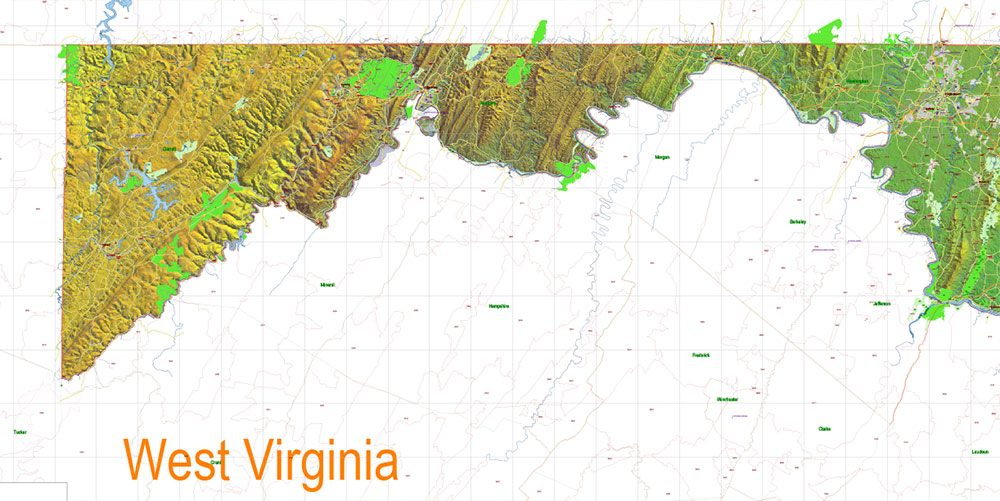
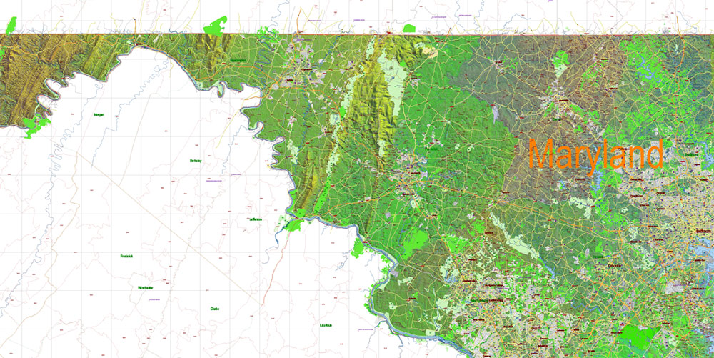
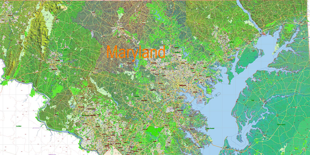
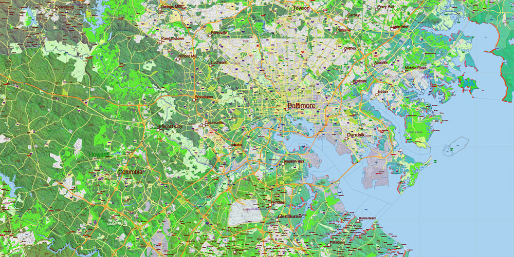
Printable Shaded Relief PDF Vector Map of Maryland State Extended Version – US Extra High detailed State Plan scale 1:58526 full editable Adobe PDF Road + Counties + ZipCodes Shaded Relief Map in layers, scalable, text format all names, 365 MB ZIP
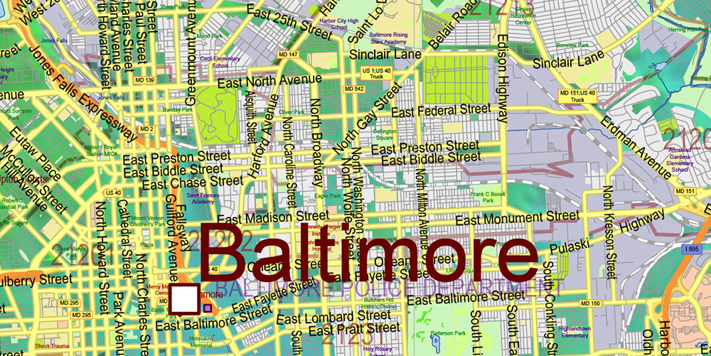
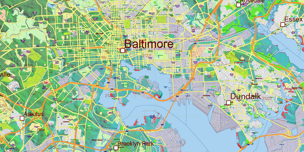
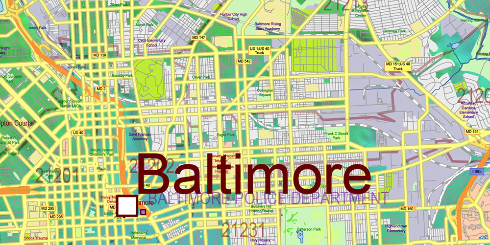
Principal street names, ALL STREETS AND ROADS, Main Objects, Counties, Zipcodes, addon layers – Cities / towns by population categories by layers, Shaded Relief JPG. Map for design, printing, arts, projects, presentations, for architects, designers, and builders, business, logistics.
Included: Simple map of Maryland state.
Maryland State US PDF Map Vector Shaded Relief Extended Exact High Detailed Street Road Map + Counties + Zipcodes editable Adobe PDF in layers
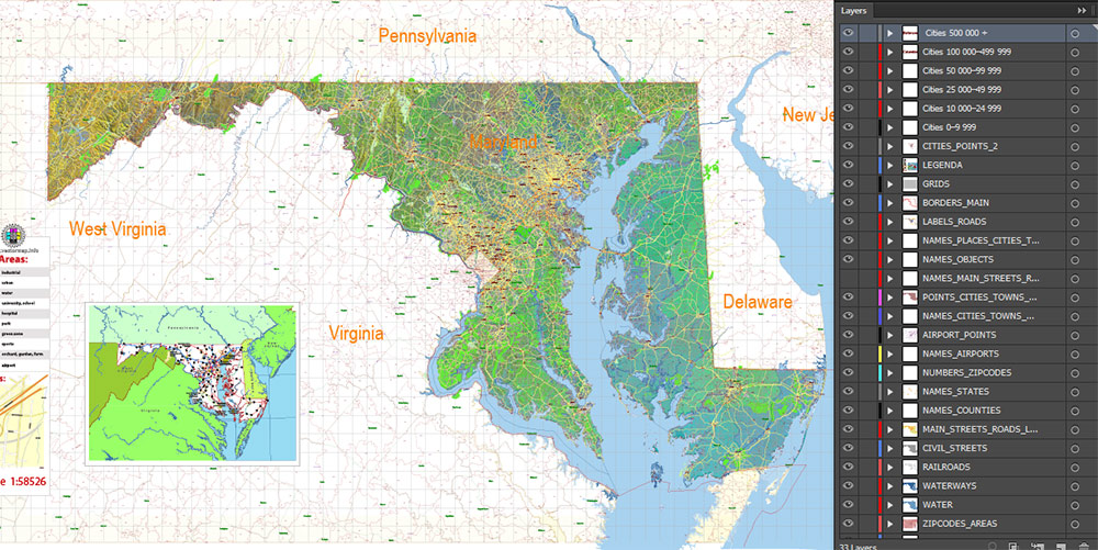
Layers list Maryland State Roads Admin map:
- Legend
- Grids
- Labels of roads
- Addon layers – Cities by population categories + addon points
- Points of airports
- Names of airports
- Names of places (city, hamlet, etc.)
- Names of cities, towns, hamlets 2
- Names of objects (hospitals, schools, parks, water)
- Points of cities, towns, hamlets
- Names of Main streets
- Main Streets, roads.
- Civil streets
- Railroads
- Waterways (lines)
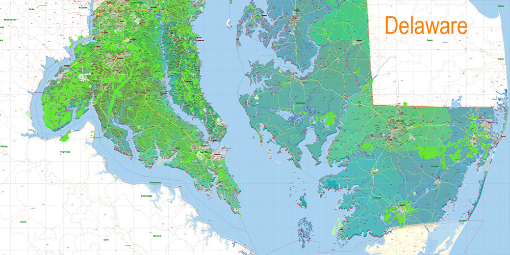
- Water objects (rivers, lakes, ponds) areas
- Names of Counties
- Names of States
- Zipcodes areas
- Zipcodes numbers
- Counties areas
- States areas
- Color fills (parks, hospital areas, school areas, etc.)
- Shaded Relief Raster JPG
- Background and sea
The most exact and detailed map of the State of Maryland in scale.
ALSO: DWG, DXF, CDR and other formats: free convert for our customers.
For Editing and High-Quality Printing
AO BRIEF — MARYLAND (STATEWIDE)
Shaded Relief • Extended Version
Operational Overview
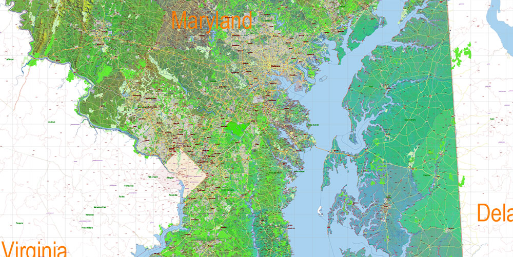
Extended, extra-high-detail shaded relief vector map of the State of Maryland. Full statewide coverage with dense transport, administrative, and demographic layers. Engineered for precision design, analytical layouts, and professional large-format printing without scale limitations.
Terrain & Shaded Relief
-
Subtle but expressive shaded relief highlighting Maryland’s diverse terrain
-
Clear differentiation between Appalachian uplands, Piedmont plateau, Atlantic Coastal Plain, and Chesapeake Bay lowlands
-
Terrain shading enhances depth without obscuring dense urban and road data
-
Effective representation of elevation transitions, river valleys, and coastal morphology
Lines of Communication (Road Network)
-
ALL streets and roads included, from interstates to local streets
-
Principal street names explicitly labeled
-
Road hierarchy remains readable even in high-density urban zones
-
Optimized for transport analysis, logistics, and infrastructure planning
Administrative & Analytical Layers
-
Counties fully delineated and labeled
-
ZIP Code boundaries included as dedicated analytical layers
-
Layer structure allows selective visualization for planning and presentation use
Urban & Demographic Structure
-
Cities and towns categorized by population and separated into logical layers
-
Supports demographic analysis, regional planning, and visual hierarchy control
-
Settlement patterns clearly correlated with terrain and transport corridors
Hydrography & Major Objects
-
Chesapeake Bay, rivers, estuaries, and water bodies accurately integrated
-
Coastal and inland water systems clearly legible against shaded terrain
-
Major physical and infrastructural objects included for spatial context
Map Engineering & Data Integrity
-
Fully editable vector Adobe PDF with layered architecture
-
All labels in text format — no rasterized names
-
Shaded relief supplied as high-quality raster layer (JPG)
-
Unlimited print scaling without loss of vector detail
Command Takeaways
-
Terrain-aware, data-dense map suitable for advanced professional use
-
Balanced shaded relief supporting both analysis and design
-
Ideal for architects, planners, logistics, and technical presentations
-
Built for users who require maximum detail and control
Maryland State US PDF Map Vector Shaded Relief Extended Exact High Detailed Street Road Map + Counties + Zipcodes editable Adobe PDF in layers
Maryland State US PDF Map Vector Shaded Relief Extended Exact High Detailed Street Road Map + Counties + Zipcodes editable Adobe PDF in layers
Maryland State US PDF Map Vector Shaded Relief Extended Exact High Detailed Street Road Map + Counties + Zipcodes editable Adobe PDF in layers
Maryland State US PDF Map Vector Shaded Relief Extended Exact High Detailed Street Road Map + Counties + Zipcodes editable Adobe PDF in layers
Maryland State US PDF Map Vector Shaded Relief Extended Exact High Detailed Street Road Map + Counties + Zipcodes editable Adobe PDF in layers
Maryland State US PDF Map Vector Shaded Relief Extended Exact High Detailed Street Road Map + Counties + Zipcodes editable Adobe PDF in layers
Maryland State US PDF Map Vector Shaded Relief Extended Exact High Detailed Street Road Map + Counties + Zipcodes editable Adobe PDF in layers
Maryland State US PDF Map Vector Shaded Relief Extended Exact High Detailed Street Road Map + Counties + Zipcodes editable Adobe PDF in layers
Maryland State US PDF Map Vector Shaded Relief Extended Exact High Detailed Street Road Map + Counties + Zipcodes editable Adobe PDF in layers


 Author: Kirill Shrayber, Ph.D. FRGS


 Street Map editable Adobe Illustrator in layers")