Trondheim vector map in Adobe Illustrator (*.AI) and other vector formats
Trondheim vector map AI archive size: 123 Mb
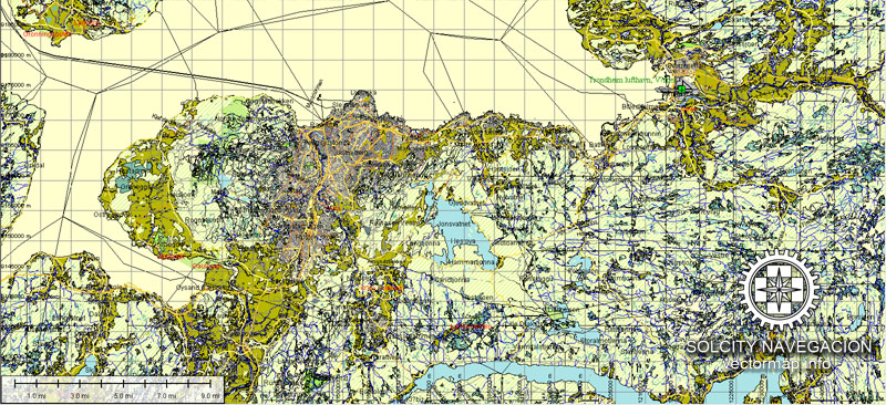
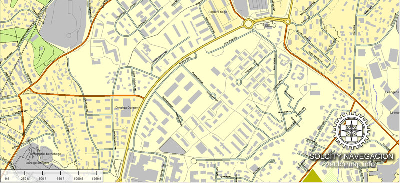
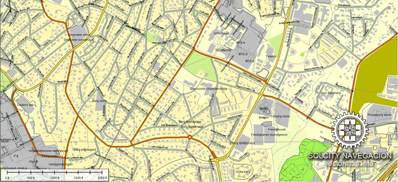
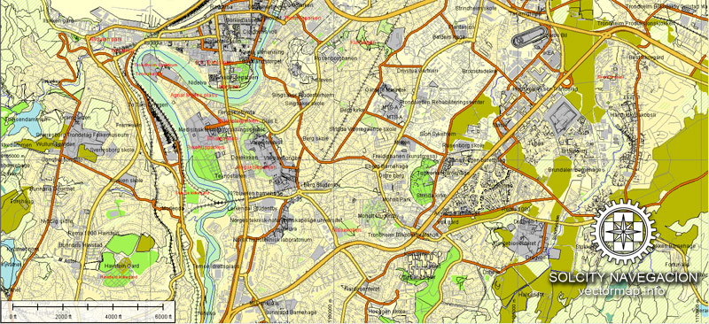
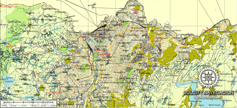
This vector map of Trondheim, Norway, contain all streets with names, some main buildings, airports and coordinate datum. Please, see the attached preview images of map.
Example of Trondheim, Norway map in Adobe Illustrator, FREE DOWNLOAD.
About Royalty Free license: you can edit/copy – do all you want with NO extra fee.
DPI: 300
Our vector map collection contain just all countries and cities all over the world, but if you need something special – please contact us.
Trondheim, Norway.
This vector map of Trondheim is used as a basis for design, editing, and further printing.
This is the most detailed, exact map of Trondheim for high-quality printing and polygraphy. You can always clarify the map development date by contacting us.
For your convenience, all objects on Trondheim vector map are divided into layers. And the editing is very easy – colors, lines, etc.
You can easily add any objects needed (e.g. shops, salons, sale points, gas station or attraction) on any layer of Trondheim vector map.
Trondheim is a city and municipality in Trøndelag county, Norway. It has a population of 193,501 (4th quarter 2017), and is the third-most populous municipality in Norway, although the fourth largest urban area. It is the third largest city in the country, with a population (2013) of 169,972 inhabitants within the city borders. Trondheim lies on the south shore of Trondheim Fjord at the mouth of the River Nidelva. The city is dominated by the Norwegian University of Science and Technology (NTNU), the Foundation for Scientific and Industrial Research (SINTEF), St. Olavs University Hospital and other technology-oriented institutions.
One of the advantages of Trondheim vector maps of our production is the relevance of cartographic data, we constantly update all our products.
This vector map of Trondheim is used by:
designers, layout designers, printers, advertisers and architects. Our product – vector maps – is designed for further editing and printing in large formats – from @Wall format (a few meters) to A-0 and A-1, A-2, A-3.
Trondheim map in vector format is used for design, urban planning, presentations and media visualizations.
Advertising and presentation map of Trondheim (usually the final designer marks the routes, and puts the client’s objects (shops, saloons, gas stations etc.)
The undoubted advantage is that people will NEVER throw out this advertising product – the map. In fact, as an advertising medium, a map is the most “long-playing” of the well-known polygraphic advertising media, with the longest lifespan, and the maximum number of interactions with the customer.
For travelers, maps are sold at the airports and gas stations around the world. Often the source is our vector maps.
Take a look, who purchases our vector maps of Trondheim in “Our Clients and Friends” page – these are large and small companies, from super-brands like Volvo and Starbucks, to small design studios and printing houses.
It’s very easy to work with vector maps of Trondheim, even for a not very experienced designer who can turn on and off the map layers, add new objects, change the colors of fill and lines according to customer requirements.
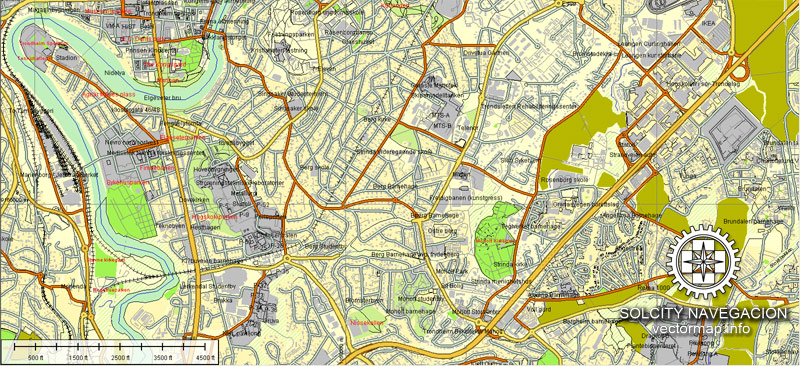
The undoubted advantage of Trondheim vector maps in printing is an excellent and detailed visualization, when customer can expand a large paper map and instantly define his location, find a landmark, an object or address on map, unlike using the popular electronic formats of Google and Yandex maps for example.
Printable vector maps of Trondheim are much more convenient and efficient than any electronic maps on your smartphone, because ALL DETAILS are displayed in the entire space of Trondheim map.
Useful tips on working with vector maps of cities and countries in Adobe Illustrator.
«V» – launches the Selection tool (cursor, black arrow), which makes active any vector line.
«А» – launches the Direct Selection tool (white cursor), allows you to select curve elements and drag them to the desired place.
«R» – activates the Rotate tool, which helps you rotating selected objects around the center point by 360 degrees.
«E» – gives you the opportunity to use the Eraser tool and erase unnecessary parts.
«X» – switches between Fill and Stroke in the Tools section. Try to get used to this hot key and
you will quickly understand that you can’t live and work without it.
Guides are not limited to vertical and horizontal in Adobe Illustrator. You can also create a diagonal guide for example. Moreover, you can turn any contours into guides. Select the outline and go to View > Guides > Make Guides (Create Guides), or simply press Cmd/Ctrl + 5. You can also turn the guides back into an editable object. Go to menu, View > Guides > Unlock Guides (Release Guides), select the guide you want to edit and select View > Guides > Release Guides (Reset Guides), or just press Cmd/Ctrl + Option / Alt + 5).
You will probably want to change the color scheme used on our Trondheim vector map.
To quickly and effectively play with colors.
Of course, you can do it manually, all objects in our Trondheim vector map are divided according to types and layers, and you can easily change the color gamma of vector objects in groups and layers.
But there is more effective way of working with the whole VECTOR MAP of Trondheim and all layers:
The overview dialog «Edit colors»/«Repaint Graphic Object» (this dialog box name can change depending on the context):
If you have selected a part or a layer of Trondheim vector map and open the dialog box by clicking the icon in the Control panel, on the Samples palette or the Color Catalog, or if you choose Edit > Edit Colors> Repaint Graphic Object, then the «Repaint Graphic Object» dialog box appears, and you get access to «Assign» and «Edit» tabs.
If a picture or a map fragment is not selected, and you open the dialog box by clicking the icon in the Control panel, on the Samples palette or in the Color Catalog, the «Edit Colors» dialog box appears and you can only access the «Edit» tab.
Regardless of the name at the top of the dialog box, the right-hand side always displays the color group of the current document, as well as two default color groups: Print Color and Grayscale. These color groups can be selected and used any time.
Create and edit color groups of Trondheim vector map, and also assign colors using the «Edit Colors»/ а «Repaint Graphic Object» dialog box.
A. Creating and editing of a color group on the «Edit» tab
B. Assigning colors on the «Assign» tab
C. Select a group of colors from the «Color groups» list
The option «Repaint a graphic object» in the lower part of the dialog box allows you to preview the colors on a selected layer of Vector map, or a group of elements, and specify whether its colors will be redefined when the dialog box is closed.
The main areas of the dialog box are:
«Edit»
The «Edit» tab is designed to create a new or edit the existing color groups.
The harmony rules Menu and the Color Wheel are used to conduct experiments with color harmonies. The color wheel shows how colors are related in color harmony, and the color bars allow you to view and manipulate an individual color values. In addition, you can adjust the brightness, add and remove colors, save color groups and view colors on the selected Vector Map of Trondheim or a separated layers.
«Assign»
The «Assign» tab is used to view and control on how the original colors are replaced with colors from the color group like your corporate colors in the Vector Map of Trondheim.
The assign color ability is provided only if the entire map, layer or fragment is selected in the document. You can specify which of new colors replace the current colors, whether the spot colors should be preserved and how colors are replaced (for example, you can replace colors completely or changing the color tone while maintaining the brightness). The «Assign» tab allows you to redefine colors in the Vector Map of Trondheim, or in separate layers and fragments using the current color group or reducing the number of colors in the current Vector Map.
Color groups
Is a list of all saved color groups for current document (the same groups appear in the «Samples» palette). You can edit and delete the existing color groups, as well as creating a new ones using the list of “Color Groups” in the dialog box. All changes appear in the «Samples» palette.
The highlighted color group shows, which color group is currently edited.
Any color group can be selected and edited, or used to redefine the colors in the selected vector map of Trondheim, its fragments or elements.
Saving a color group adds this group to the specified list.
Opening the «Edit Colors»/«Repaint Graphic Object» dialog box.
Open the «Edit Colors»/«Repaint Graphic Object» dialog box using one of the following methods:
«Edit»> «Edit Colors»> «Repaint Graphic object» or «Repaint With Style».
Use these commands if you need to edit the colors in the selected vector map of Trondheim.
«Repaint Graphic object» button on the «Control» panel.
Use this button if you need to adjust colors of Trondheim vector map using the а «Repaint graphic object» dialog box.
The specified button is available if the selected vector map or its fragment contains two or more colors.
Note. This color editing method is convenient for global color adjustment in a vector map, if global colors were not used when creating a Map of Trondheim.
The «Edit colors» button or «Edit or apply colors» on the «Color Catalog» palette
Click this button if you need to edit colors on the «Color Catalog» palette or edit and then apply them to the selected Vector Map of Trondheim or its fragment.
The «Edit color group» button or «Edit or apply color group» on the «Samples» palette.
Click this button if you need to edit the colors in the specific color group or edit and apply them to the selected Vector Map of Trondheim or a group of its elements, for example, the whole layer “Streets and lines”. You can also double-click the color group in the Samples panel to open the dialog box.
If the map file is too large and your computer freezes or even can’t open it quickly:
1. Try to reduce the color resolution of the video card (display) to 256 colors while working with a large map.
2. Using Windows Task Manager, select all the application you don’t need, while working with map, just turn them off.
3. Launch Adobe Illustrator. (DO NOT OPEN the vector map file)
4. Start the Windows Task Manager using administrator rights > Find the “Illustrator” process > set the «real time» priority,
5. Open the file. When you see the LEGACY FONT popup window – click “OK” (do not update). You can restore the TEXT later.
6. Can also be useful: When file is opened – Edit > Settings > Basic Settings > disable smoothing. /// It looks scary, but works quickly)))
We recommend saving the file in Adobe Illustrator 10 version. It’s much more stable when working with VERY BIG size files.
The settlement was founded in 997 as a trading post, and it served as the capital of Norway during the Viking Age until 1217. From 1152 to 1537, the city was the seat of the Catholic Archdiocese of Nidaros; since then, it has remained the seat of the Lutheran Diocese of Nidaros and the Nidaros Cathedral. It was incorporated in 1838. The current municipality dates from 1964, when Trondheim merged with Byneset, Leinstrand, Strinda and Tiller.
The city functions as the seat of the County Mayor of Trøndelag county, but not as the administrative centre, which is Steinkjer. This is to make the county more efficient and not too centralized, as Trøndelag is the second largest county in Norway.
Geography
Trondheim is situated where the River Nidelva meets Trondheim Fjord with an excellent harbour and sheltered condition. The river used to be deep enough for most boats in the Middle Ages. An avalanche of mud and stones made it less navigable and partly ruined the harbour in the mid-17th century. The municipality’s top elevation is the Storheia hill, 565 metres (1,854 ft) above sea level. At the summer solstice, the sun rises at 03:00 and sets at 23:40, but stays just below the horizon–there is no darkness (no need for artificial lighting outdoors) from 23 May to 19 July under cloud-free conditions. At the winter solstice, the sun rises at 10:01, stays very low above the horizon (at midday its altitude is slightly more than 3 degrees over the horizon), and sets at 14:31.
Our Trondheim Adobe Illustrator (.AI) maps feature:
Highways with names,
Major streets with names,
Major Roads,
Pipeline,
National Park Borders,
Airports,
Railway lines with stops,
Latitude and Longitude data,
Minor Roads,
Private Roads,
Cemeteries,
Big and small Rivers, small streams also,
Lake, ponds and other water bodies,
Landmark fill,
Recreation zones,
County Borders with fill,
Sidewalk/Walkway/Pedestrian roads,
Power Lines,
Parks.
By request, if needed:
POI (Points of Interest) like: restaurants, hospital, shops, drugstores, military objects or tourist attractive points.
Our maps can be suited to any size needed. Perfect for presentation or large size printing, like office walls (we are sure, Big Boss wants one of this) or bigboards. We provide detailed maps of Leipzig (Deutschland) in AI. Being vector maps, they are completely editable, you can add your company logo or change fonts style, line thickness or borders. Need more objects (POI) on map? We can add it with no extra fee. Separated layers, you can turn on or off layer needed.
You can customize all map data using different vector graphics editors like: Adobe Illustrator, Freehand or CorelDraw, Autocad or Freehand. And also is a fully scalable map, no matter what size you need.
Trondheim city vectorial map. Cities and counties near
This version of Trondheim Adobe Illustrator vector map may includes maps of the nearest areas (see the preview):
Midtbyen, Øya-Singsaker, Lademoen, Lade, Strindheim, Charlottenlund-Jakobsli, Ranheim, Berg-Tyholt, Nardo, Nidarvoll-Leira, Byneset-Leinstrand, Bratsberg, Åsvang-Stokkan, Tiller/Tillerbyen, Ila-Trolla, Sverresborg, Jonsvatnet, Moholt, Byåsen, Rosenborg-Møllenberg, Flatåsen-Saupstad, Risvollan-Othilienborg, Heimdal, Sjetne-Okstad, Hallset and others.
Adobe Illustrator Trondheim vectorial map. Purchasing and downloading.
Credit Card and PayPal payment accepted. After the payment you will be redirected to the download page.
We also offer custom mapping. If you need something special – just contact our friendly team.
Small guide: How to work with the vector map?
You can: Mass select objects by type and color – for example, the objects type “building” (they are usually dark gray) – and remove them from the map, if you do not need them in your print or design project. You can also easily change the thickness of lines (streets), just bulk selection the road by the line color.
The streets are separated by type, for example, type “residential road” are usually white with a gray stroke. Highway usually orange with a brown or dark gray stroke.
All objects are divided by types: different types of roads and streets, polygons of buildings, landfills, urban areas, parks and more other.
It is easy to change the font of inscriptions, all or each individually. Also, just can be make and any other manipulation of objects on the vector map in Adobe illustrator format.
Important: All the proportions on the map are true, that is, the relative sizes of the objects are true, because Map is based on an accurate GPS projection, and It transated into the (usual for all) the Mercator projection.
You can easily change the color, stroke and fill of any object on the map, zoom without loss of quality Image Verification.
See more printable, editable and scalable maps of Norway cities
Vector map of Trondheim city in Norway
Bergen city printable street map in vector, Norway
Full Norway printable vector map
Vector street map of Oslo (Norway, Europe)


 Author: Kirill Shrayber, Ph.D. FRGS
