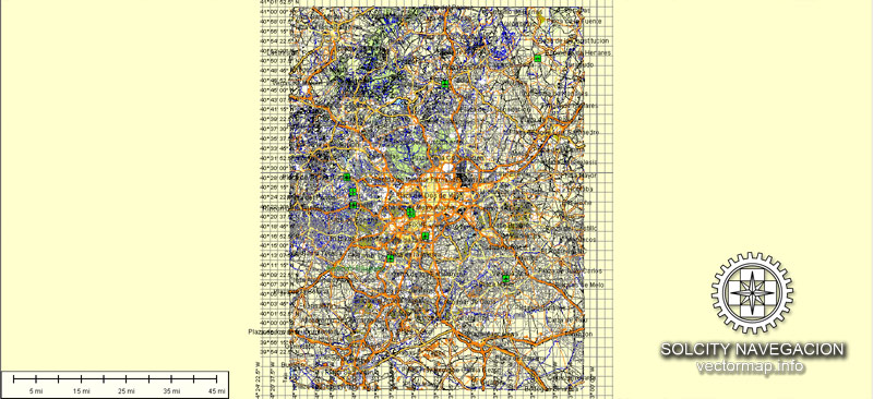
Madrid vectorial map in AI (Illustrator) Atlas 49 parts. Spain, Europe
Archive size: 105 Mb, zipped .AI
DPI: 300
This vector maps of Madrid is created using 2015 data.
License: Royalty Free
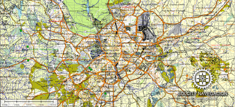
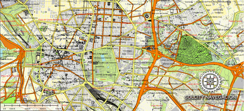
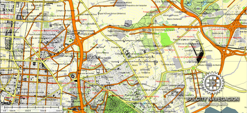
Madrid (Spain) vector maps in Adobe Illustrator format (.AI) features (check the preview images):
Highways with names,
Major Roads,
National Park Borders,
Minor Roads,
Big and small Rivers, small streams also,
Lake, ponds and other water bodies,
Landmark fill,
Houses,
Railway,
Recreation zones,
Parks.
By request, if needed:
POI (Points of Interest) like: restaurants, hospital, shops, drugstores, military objects or tourist attractive points.
Our maps can be suited to any size needed. Perfect for presentation or large size printing, like office walls (we are sure, Big Boss wants one of this) or bigboards. We provide detailed maps of Madrid (Spain) in AI. Being vector maps, they are completely editable, you can add your company logo or change fonts style, line thickness or borders. Need more objects (POI) on map? We can add it with no extra fee. Separated layers, you can turn on or off layer needed.
Please also check other vector maps of Spain we have.
Madrid, Spain.
This vector map of Madrid city is used as a basis for design, editing, and further printing.
This is the most detailed, exact map of Madrid city for high-quality printing and polygraphy. You can always clarify the map development date by contacting us.
For your convenience, all objects on Madrid vector city map are divided into layers. And the editing is very easy – colors, lines, etc.
You can easily add any objects needed (e.g. shops, salons, sale points, gas station or attraction) on any layer of Madrid vector map.
Madrid is the capital of Spain and the largest municipality in both the Community of Madrid and Spain as a whole. The city has almost 3.2 million inhabitants and a metropolitan area population of approximately 6.5 million. It is the third-largest city in the European Union (EU), smaller than only London and Berlin, and its monocentric metropolitan area is the third-largest in the EU, smaller only than those of London and Paris. The municipality covers 604.3 km2 (233.3 sq mi).
One of the advantages of Madrid city vector maps of our production is the relevance of cartographic data, we constantly update all our products.
This vector map of Madrid city is used by:
designers, layout designers, printers, advertisers and architects. Our product – vector maps – is designed for further editing and printing in large formats – from @Wall format (a few meters) to A-0 and A-1, A-2, A-3.
Madrid city map in vector format is used for design, urban planning, presentations and media visualizations.
Advertising and presentation map of Madrid city (usually the final designer marks the routes, and puts the client’s objects (shops, saloons, gas stations etc.)
The undoubted advantage is that people will NEVER throw out this advertising product – the map. In fact, as an advertising medium, a city map is the most “long-playing” of the well-known polygraphic advertising media, with the longest lifespan, and the maximum number of interactions with the customer.
Madrid lies on the River Manzanares in the centre of both the country and the Community of Madrid (which comprises the city of Madrid, its conurbation and extended suburbs and villages); this community is bordered by the autonomous communities of Castile and León and Castile-La Mancha. As the capital city of Spain, seat of government, and residence of the Spanish monarch, Madrid is also the political, economic and cultural centre of the country. The current mayor is Manuela Carmena from the party Ahora Madrid.
For travelers, maps are sold at the airports and gas stations around the world. Often the source is our vector maps.
Take a look, who purchases our vector maps of Madrid city in “Our Clients and Friends” page – these are large and small companies, from super-brands like Volvo and Starbucks, to small design studios and printing houses.
It’s very easy to work with vector maps of Madrid city, even for a not very experienced designer who can turn on and off the map layers, add new objects, change the colors of fill and lines according to customer requirements.
The undoubted advantage of Madrid city vector maps in printing is an excellent and detailed visualization, when customer can expand a large paper map and instantly define his location, find a landmark, an object or address on map, unlike using the popular electronic formats of Google and Yandex maps for example.
Printable vector maps of Madrid city are much more convenient and efficient than any electronic maps on your smartphone, because ALL DETAILS are displayed in the entire space of Madrid city map.
Useful tips on working with vector maps of cities and countries in Adobe Illustrator.
«V» – launches the Selection tool (cursor, black arrow), which makes active any vector line.
«А» – launches the Direct Selection tool (white cursor), allows you to select curve elements and drag them to the desired place.
«R» – activates the Rotate tool, which helps you rotating selected objects around the center point by 360 degrees.
«E» – gives you the opportunity to use the Eraser tool and erase unnecessary parts.
«X» – switches between Fill and Stroke in the Tools section. Try to get used to this hot key and
you will quickly understand that you can’t live and work without it.
The Madrid urban agglomeration has the third-largest GDP in the European Union and its influences in politics, education, entertainment, environment, media, fashion, science, culture, and the arts all contribute to its status as one of the world’s major global cities. Madrid is home to two world-famous football clubs, Real Madrid and Atlético de Madrid. Due to its economic output, high standard of living, and market size, Madrid is considered the major financial centre of Southern Europe and the Iberian Peninsula; it hosts the head offices of the vast majority of major Spanish companies, such as Telefónica, IAG or Repsol. Madrid is the 10th most liveable city in the world according to Monocle magazine, in its 2017 index.
Guides are not limited to vertical and horizontal in Adobe Illustrator. You can also create a diagonal guide for example. Moreover, you can turn any contours into guides. Select the outline and go to View > Guides > Make Guides (Create Guides), or simply press Cmd/Ctrl + 5. You can also turn the guides back into an editable object. Go to menu, View > Guides > Unlock Guides (Release Guides), select the guide you want to edit and select View > Guides > Release Guides (Reset Guides), or just press Cmd/Ctrl + Option / Alt + 5).
You will probably want to change the color scheme used on our Madrid vector city map.
To quickly and effectively play with colors.
Of course, you can do it manually, all objects in our Madrid city vector map are divided according to types and layers, and you can easily change the color gamma of vector objects in groups and layers.
But there is more effective way of working with the whole VECTOR MAP of Madrid city and all layers:
The overview dialog «Edit colors»/«Repaint Graphic Object» (this dialog box name can change depending on the context):
If you have selected a part or a layer of Madrid city vector map and open the dialog box by clicking the icon in the Control panel, on the Samples palette or the Color Catalog, or if you choose Edit > Edit Colors> Repaint Graphic Object, then the «Repaint Graphic Object» dialog box appears, and you get access to «Assign» and «Edit» tabs.
Madrid houses the headquarters of the World Tourism Organization (UNWTO), belonging to the United Nations Organization (UN), the Ibero-American General Secretariat (SEGIB), the Organization of Ibero-American States (OEI), and the Public Interest Oversight Board (PIOB). It also hosts major international regulators and promoters of the Spanish language: the Standing Committee of the Association of Spanish Language Academies, headquarters of the Royal Spanish Academy (RAE), the Cervantes Institute and the Foundation of Urgent Spanish (Fundéu BBVA). Madrid organises fairs such as FITUR, ARCO, SIMO TCI and the Cibeles Madrid Fashion Week.
If a picture or a map fragment is not selected, and you open the dialog box by clicking the icon in the Control panel, on the Samples palette or in the Color Catalog, the «Edit Colors» dialog box appears and you can only access the «Edit» tab.
Regardless of the name at the top of the dialog box, the right-hand side always displays the color group of the current document, as well as two default color groups: Print Color and Grayscale. These color groups can be selected and used any time.
Create and edit color groups of Madrid city vector map, and also assign colors using the «Edit Colors»/ а «Repaint Graphic Object» dialog box.
A. Creating and editing of a color group on the «Edit» tab
B. Assigning colors on the «Assign» tab
C. Select a group of colors from the «Color groups» list
The option «Repaint a graphic object» in the lower part of the dialog box allows you to preview the colors on a selected layer of Vector map, or a group of elements, and specify whether its colors will be redefined when the dialog box is closed.
The main areas of the dialog box are:
«Edit»
The «Edit» tab is designed to create a new or edit the existing color groups.
The harmony rules Menu and the Color Wheel are used to conduct experiments with color harmonies. The color wheel shows how colors are related in color harmony, and the color bars allow you to view and manipulate an individual color values. In addition, you can adjust the brightness, add and remove colors, save color groups and view colors on the selected Vector Map of Madrid city or a separated layers.
While Madrid possesses modern infrastructure, it has preserved the look and feel of many of its historic neighbourhoods and streets. Its landmarks include the Royal Palace of Madrid; the Royal Theatre with its restored 1850 Opera House; the Buen Retiro Park, founded in 1631; the 19th-century National Library building (founded in 1712) containing some of Spain’s historical archives; a large number of national museums, and the Golden Triangle of Art, located along the Paseo del Prado and comprising three art museums: Prado Museum, the Reina Sofía Museum, a museum of modern art, and the Thyssen-Bornemisza Museum, which completes the shortcomings of the other two museums. Cibeles Palace and Fountain have become one of the monument symbols of the city. Madrid is the most visited city of Spain.
«Assign»
The «Assign» tab is used to view and control on how the original colors are replaced with colors from the color group like your corporate colors in the Vector Map of Madrid city.
The assign color ability is provided only if the entire map, layer or fragment is selected in the document. You can specify which of new colors replace the current colors, whether the spot colors should be preserved and how colors are replaced (for example, you can replace colors completely or changing the color tone while maintaining the brightness). The «Assign» tab allows you to redefine colors in the Vector Map of Madrid city, or in separate layers and fragments using the current color group or reducing the number of colors in the current Vector Map.
Color groups
Is a list of all saved color groups for current document (the same groups appear in the «Samples» palette). You can edit and delete the existing color groups, as well as creating a new ones using the list of “Color Groups” in the dialog box. All changes appear in the «Samples» palette.
The highlighted color group shows, which color group is currently edited.
Any color group can be selected and edited, or used to redefine the colors in the selected vector map of Madrid city, its fragments or elements.
Saving a color group adds this group to the specified list.
Opening the «Edit Colors»/«Repaint Graphic Object» dialog box.
Open the «Edit Colors»/«Repaint Graphic Object» dialog box using one of the following methods:
«Edit»> «Edit Colors»> «Repaint Graphic object» or «Repaint With Style».
Use these commands if you need to edit the colors in the selected vector map of Madrid city.
«Repaint Graphic object» button on the «Control» panel.
Use this button if you need to adjust colors of Madrid city vector map using the а «Repaint graphic object» dialog box.
The specified button is available if the selected vector map or its fragment contains two or more colors.
Note. This color editing method is convenient for global color adjustment in a vector map, if global colors were not used when creating a City Map of Madrid.
The «Edit colors» button or «Edit or apply colors» on the «Color Catalog» palette
Click this button if you need to edit colors on the «Color Catalog» palette or edit and then apply them to the selected Vector Map of Madrid city or its fragment.
The «Edit color group» button or «Edit or apply color group» on the «Samples» palette.
Click this button if you need to edit the colors in the specific color group or edit and apply them to the selected Vector Map of Madrid city or a group of its elements, for example, the whole layer “Streets and lines”. You can also double-click the color group in the Samples panel to open the dialog box.
If the map file is too large and your computer freezes or even can’t open it quickly:
1. Try to reduce the color resolution of the video card (display) to 256 colors while working with a large map.
2. Using Windows Task Manager, select all the application you don’t need, while working with map, just turn them off.
3. Launch Adobe Illustrator. (DO NOT OPEN the vector map file)
4. Start the Windows Task Manager using administrator rights > Find the “Illustrator” process > set the «real time» priority,
5. Open the file. When you see the LEGACY FONT popup window – click “OK” (do not update). You can restore the TEXT later.
6. Can also be useful: When file is opened – Edit > Settings > Basic Settings > disable smoothing. /// It looks scary, but works quickly)))
We recommend saving the file in Adobe Illustrator 10 version. It’s much more stable when working with VERY BIG size files.
Geography
Madrid lies on the southern Meseta Central, 60 km south of the Guadarrama mountains and straddling the Jarama and Manzanares river basins. There is a considerable difference in altitude within city limits ranging from 543 m (1,781 ft) in the Manzanares valley to 846 m (2,776 ft) above sea level in the highest part of Fuencarral-El Pardo district. Over a quarter of the Madrid municipal area is covered by the largely forested protected area of El Pardo.
Metropolitan area
The Madrid metropolitan area comprises the city of Madrid and forty surrounding municipalities. It has a population of slightly more than 6.271 million people and covers an area of 4,609.7 square kilometres (1,780 sq mi). It is the largest metropolitan area in Spain and the third largest in the European Union.
As with many metropolitan areas of similar size, two distinct zones of urbanisation can be distinguished:
Inner ring (primera corona): Alcorcón, Leganés, Getafe, Móstoles, Fuenlabrada, Coslada, Alcobendas, Pozuelo de Alarcón, San Fernando de Henares
Outer ring (segunda corona): Villaviciosa de Odón, Parla, Pinto, Valdemoro, Rivas-Vaciamadrid, Torrejón de Ardoz, Alcalá de Henares, San Sebastián de los Reyes, Tres Cantos, Las Rozas de Madrid, Majadahonda, Boadilla del Monte
The largest suburbs are to the South, and in general along the main routes leading out of Madrid.
You can customize all map data using different vector graphics editors like: Adobe Illustrator, Freehand or CorelDraw, Autocad or Freehand. And also is a fully scalable map, no matter what size you need.
This vector map of Madrid is available in different vector formats (the same price): .AI, .CDR .DWG, .DXF, .EPS, .PDF.
Royalty Free license. You don`t pay extra: per volume sold; for each use; for period of use.
Madrid map with big “zoom” without quality degradation. The difference between raster and vector is that vector can be adjusted to any size you need with NO quality loss. Perfect for large-size printing (walls & billboards).
Probably, you need more objects to be added? Just tell us, we don`t charge for this work.
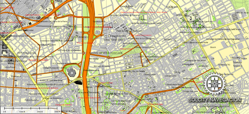
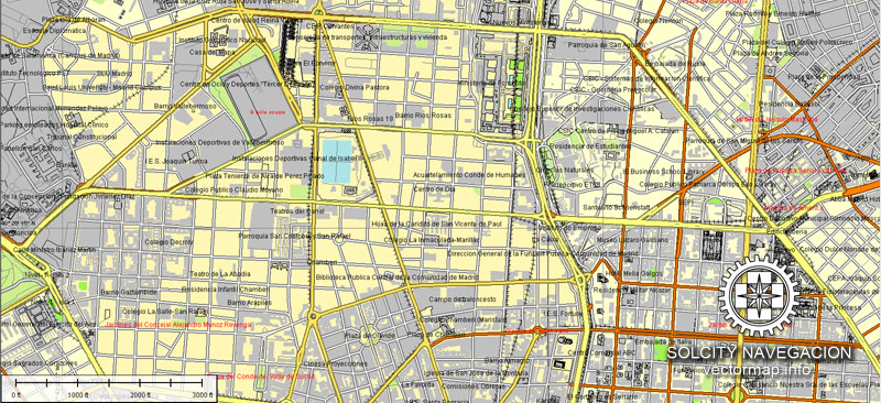
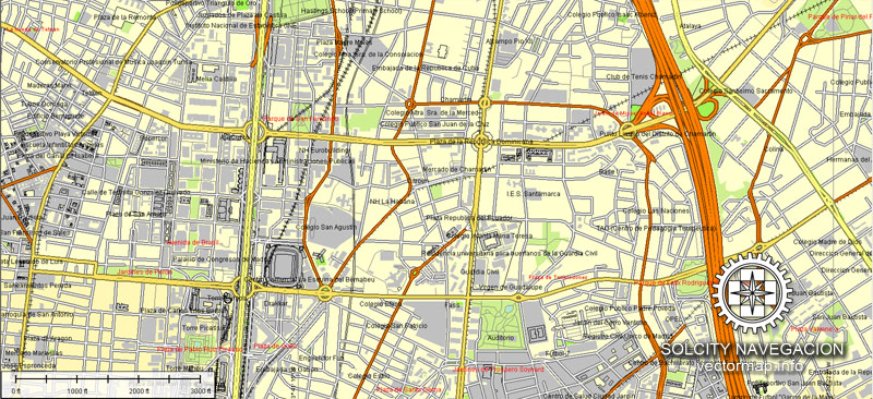
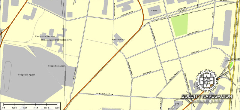
Madrid map (Spain, Europe) in vector. Cities and counties near
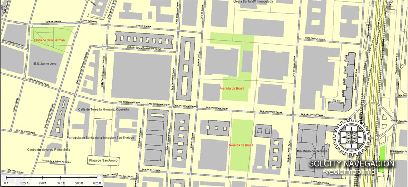
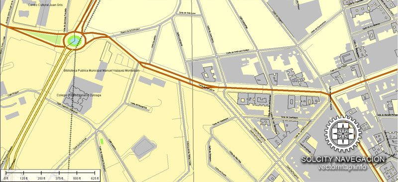
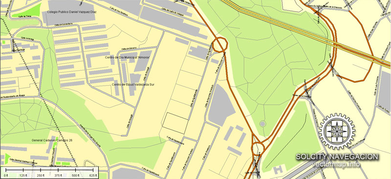
Our vector map of Madrid includes maps of the nearest areas (see the preview):
Palacio, Embajadores, Cortes, Justicia, Universidad, Sol, Imperial, Acacias, La Chopera, Legazpi, Delicias, Palos de Moguer, Atocha, Pacífico, Adelfas, Estrella, Ibiza, Jerónimos, Niño Jesús, Recoletos, Goya, Parque de las Avenidas, Fuente del Berro, Guindalera, Lista, Castellana, El Viso, Prosperidad, Ciudad Jardín, Hispanoamérica, Nueva España, Castilla, Bellas Vistas, Cuatro Caminos, Castillejos, Almenara, Valdeacederas, Berruguete, Gaztambide, Arapiles, Trafalgar, Almagro, Vallehermoso, Ríos Rosas, El Pardo, Fuentelarreina, Peñagrande, Barrio del Pilar, La Paz, Valverde, Mirasierra, El Goloso, Casa de Campo, Argüelles, Ciudad Universitaria, Valdezarza, Valdemarín, El Plantío, Aravaca, Los Cármenes, Puerta del Ángel, Lucero, Aluche, Las Águilas, Campamento, Cuatro Vientos, Abrantes, Buenavista, Comillas, Opañel, Puerta Bonita, San Isidro, Vista Alegre
Orcasitas, Orcasur, San Fermín, Almendrales, Moscardó, Zofío, Pradolongo, Entrevías, San Diego, Palomeras Bajas, Palomeras Sureste, Portazgo, Numancia, Pavones, Horcajo, Marroquina, Media Legua, Fontarrón, Vinateros, Ventas, Pueblo Nuevo, Quintana, La Concepción, San Pascual, San Juan Bautista, Colina, Atalaya, Pinar de Chamartín (Costillares), Palomas, Valdefuentes, Canillas, Pinar del Rey, Apóstol Santiago, Piovera, San Andrés, San Cristóbal, Butarque, Los Rosales, Los Ángeles, Casco Histórico de Vallecas, Santa Eugenia, Casco Histórico de Vicálvaro, Ambroz, Simancas, Hellín, Amposta, Arcos, Rosas, Rejas, Canillejas, Salvador, Parque de El Capricho, Aeropuerto, Casco Histórico de Barajas, Timón, Corralejos.
Madrid vector map for Adobe Illustrator. Purchasing and downloading.
Credit Card and PayPal payment accepted. After the payment you will be redirected to the download page.
If you need a vector map of different area, or need more objects to be shown on map, just contact our friendly team, and we add it with no extra cost.
Madrid City, Spain » City Info » Geography
Madrid is a city that comes under the Mediterranean climate. Due to high altitude winters are cooler with periodic snowfalls. Minimum temperature falls below 0 °C (32 °F). Madrid’s summer is hot with temperatures touching 30 °C (86 °F) in July and that can often reach up to 40 °C (104 °F). Due to its high altitude base and dry climate Madrid experiences cooler nights in the summer, compared to the scorching heat of the day.
Precipitation levels are low, but precipitation can be observed all throughout the year. Summer and winter are the driest seasons. Most of the rainfall occurs in the autumn and spring.
Madrid mountainous regions consist of peaks rising above 2000m. The Madrid map community conserves an ecological diversity of the evergreen Holm Oak trees in the low lying plains, in spite of the city having a population of approximately 5 million people. With excellent road links and all the facilities by the tourist board, it makes for an ideal place for the visiting birdwatcher and tourist.
Madrid’s average altitude is 650m. Most of the Madrid lies in southern sub-meseta which is comparatively flat than West region. West region rises steeply into the Sierra De of the Sistema Central, with Peñalara which is the highest mountain in Madrid. On the contrary the Province of Madrid is relatively small and situated in the heart of the Spain.
Madrid, city plan in vector, capital of Spain and of Madrid provincia (province). Spain’s arts and financial centre, the city proper and province form a comunidad autónoma (autonomous community) in central Spain.
Madrid, city, capital of Spain and of Madrid provincia (province). Spain’s arts and financial centre, the city proper and province form a comunidad autónoma (autonomous community) in central Spain.
Madrid’s status as the national capital reflects the centralizing policy of the 16th-century Spanish king Philip II and his successors. The choice of Madrid, however, was also the result of the city’s previous obscurity and neutrality; it was chosen because it lacked ties with an established, nonroyal power, rather than because of any strategic, geographic, or economic considerations. Indeed, Madrid vector map is deficient in other characteristics that might qualify it for a leading role. It does not lie on a major river, as so many European cities do; the 16th–17th century dramatist Lope de Vega, referring to a magnificent bridge over the distinctly unimposing waters of the Manzanares, suggested either selling the bridge or buying another river. Madrid printable does not possess mineral deposits or other natural wealth, nor was it ever a destination of pilgrimages, although its patron saint, San Isidro, enjoys the all-but-unique distinction of having been married to another saint. Even the city’s origins seem inappropriate for a national capital: its earliest historical role was as the site of a small Moorish fortress on a rocky outcrop—part of the northern defenses of what was then the far more important city of Toledo, located about 43 miles (70 km) south-southwest.
Similar Topics
Málaga
Ceuta
Melilla
Barcelona
Córdoba
Bilbao
Granada
Valencia
Sevilla
Santiago de Compostela
Physical and human geography of Madrid city
The landscape of Madrid
The city site and climate
Madrid lies almost exactly at the geographical heart of the Iberian Peninsula. It is situated on an undulating plateau of sand and clay known as the Meseta (derived from the Spanish word mesa, “table”) at an elevation of some 2,120 feet (646 metres) above sea level, making it one of the highest capitals in Europe. This location, together with the proximity of the Sierra de Guadarrama, is partly responsible for the weather pattern of cold, crisp winters accompanied by sharp winds. Sudden variations of temperature are possible, but summers are consistently dry and hot, becoming especially oppressive in July and August, when temperatures sometimes rise above 100 °F (38 °C). Average temperatures range between 41 and 75 °F (5 and 24 °C), while average precipitation varies between a low of less than 0.5 inch (11 mm) in July up to about 2 inches (50 mm) in October, usually the rainiest month of the year. The temperate times of year are spring and fall, which are also the most attractive seasons for visitors.
The city layout
Madrid is a city map of contrasting styles, reflecting clearly the different periods in which change and development took place. The old centre, a maze of small streets around a few squares in the vicinity of the imposing Plaza Mayor, contrasts with the stately Neoclassical buildings and grand boulevards created by the most eminent architects of their day. Modern office buildings in the centre and swaths of apartment blocks around the outskirts attest to the styles and economic realities of present-day development.
Madrid city pritnable street map, editable
Printable map of Malaga in vector


 Author: Kirill Shrayber, Ph.D. FRGS
 map, V.31.12. fully editable, Adobe Illustrator")


