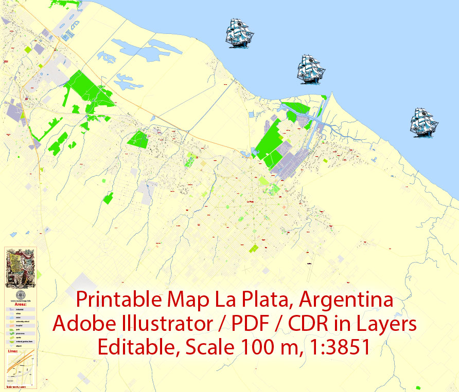
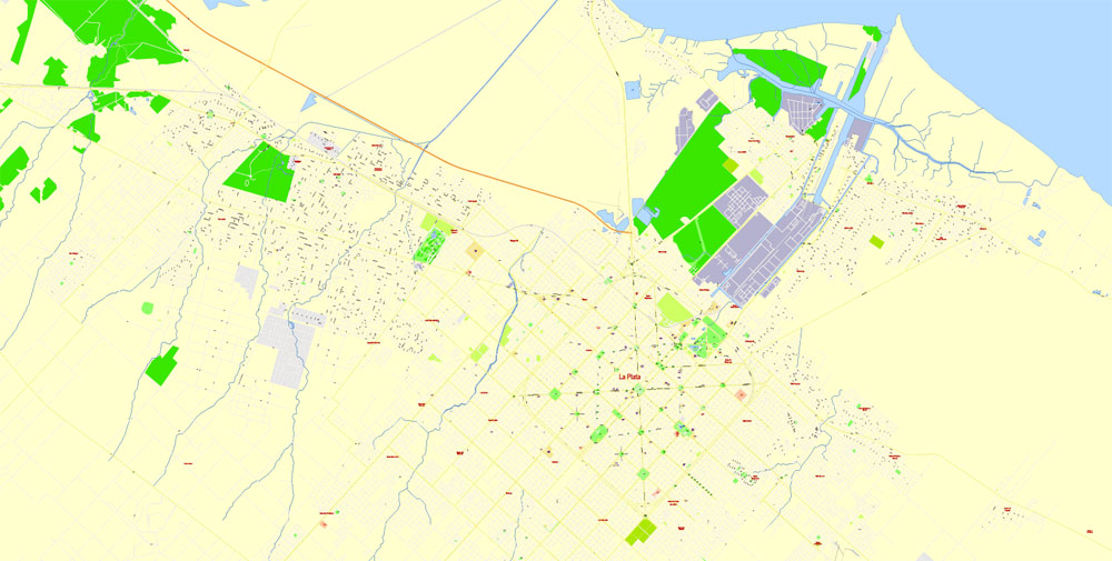
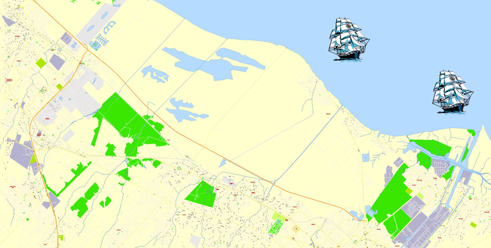
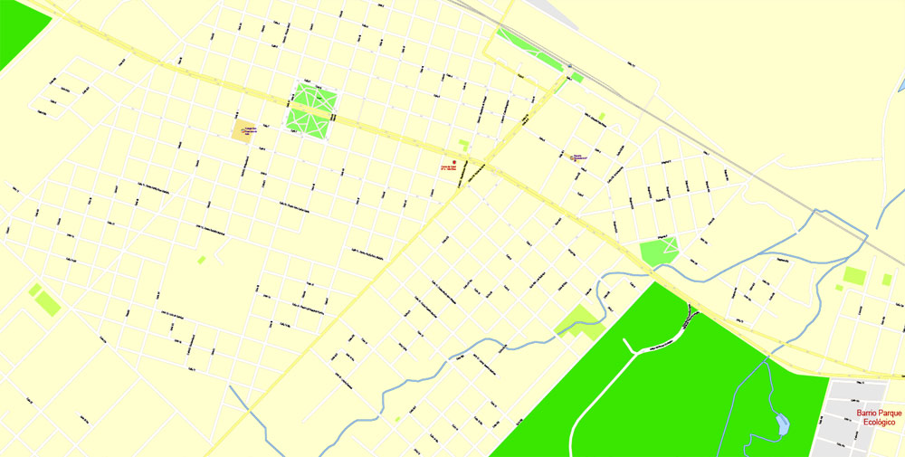
Printable Vector Map La Plata Argentina, exact detailed City Plan Street Map, scale 1:3851, editable Layered Adobe Illustrator, 9 Mb ZIP.
All streets named, main objects. Map for publishing, design, printing, publications, arts, projects, presentations, for architects, designers and builders, business, logistics. The most exact and detailed map of the city.
Layers: legend, grids, labels_roads, names_places, names_streets, names_objects, objects, arrows_streets, streets_roads, waterways, water_objects, color_fills.
Text format all names
DWG, DXF, ESRI Shapes, and other formats – by request, same price, please contact.
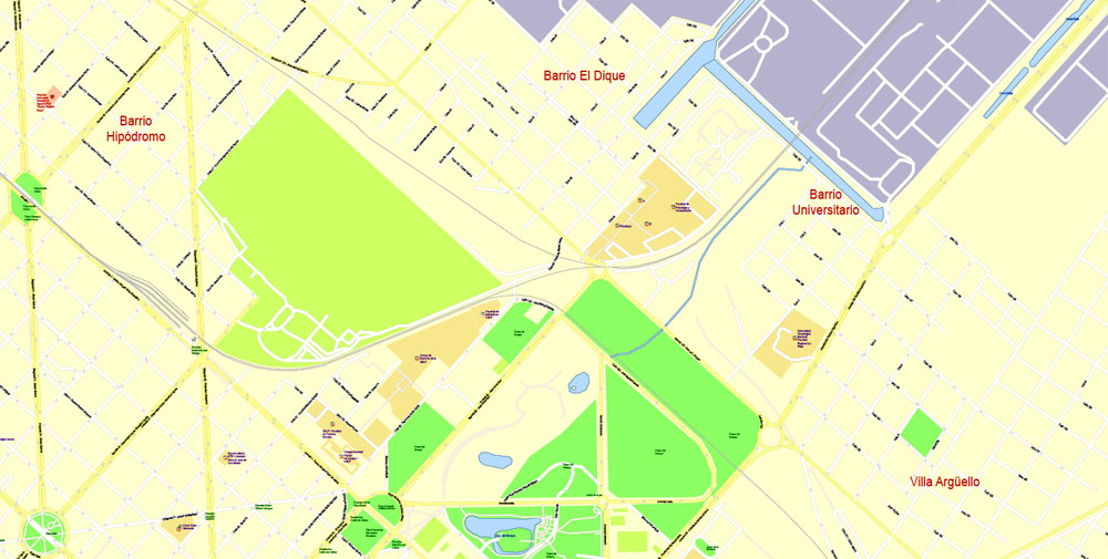
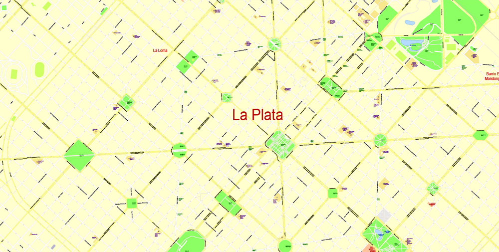
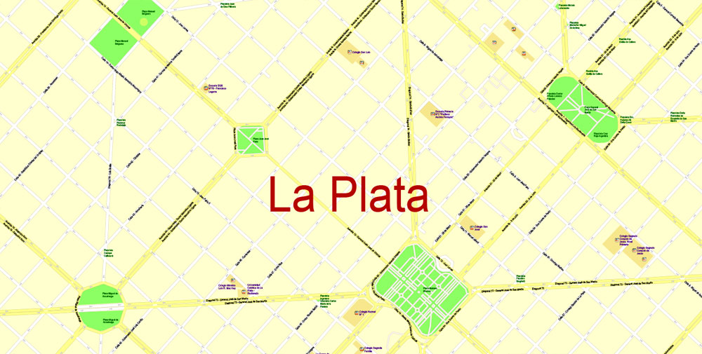
La Plata, Argentina.
This vector map of La Plata city is used as a basis for design, editing, and further printing.
This is the most detailed, exact map of La Plata city for high-quality printing and polygraphy. You can always clarify the map development date by contacting us.
For your convenience, all objects on La Plata vector city map are divided into layers. And the editing is very easy – colors, lines, etc.
You can easily add any objects needed (e.g. shops, salons, sale points, gas station or attraction) on any layer of La Plata vector map.
La Plata is the capital city of Buenos Aires Province, Argentina. According to the 2001 census, it has a population of 765,378 and its metropolitan area has 899,523 inhabitants.
One of the advantages of La Plata city vector maps of our production is the relevance of cartographic data, we constantly update all our products.
This vector map of La Plata city is used by:
designers, layout designers, printers, advertisers and architects. Our product – vector maps – is designed for further editing and printing in large formats – from @Wall format (a few meters) to A-0 and A-1, A-2, A-3.
The La Plata city map in vector format is used for design, urban planning, presentations and media visualizations.
The advertising and presentation map of La Plata city (usually the final designer marks the routes, and puts the client’s objects (shops, saloons, gas stations etc.)
The undoubted advantage is that people will NEVER throw out this advertising product – the map. In fact, as an advertising medium, a city map is the most “long-playing” of the well-known polygraphic advertising media, with the longest lifespan, and the maximum number of interactions with the customer.
For travelers, maps are sold at the airports and gas stations around the world. Often the source is our vector maps.
Take a look, who purchases our vector maps of La Plata city in “Our Clients and Friends” page – these are large and small companies, from super-brands like Volvo and Starbucks, to small design studios and printing houses.
Useful tips on working with vector maps of cities and countries in Adobe Illustrator.
«V» – launches the Selection tool (cursor, black arrow), which makes active any vector line.
«А» – launches the Direct Selection tool (white cursor), allows you to select curve elements and drag them to the desired place.
«R» – activates the Rotate tool, which helps you rotating selected objects around the center point by 360 degrees.
«E» – gives you the opportunity to use the Eraser tool and erase unnecessary parts.
«X» – switches between Fill and Stroke in the Tools section. Try to get used to this hot key and
you will quickly understand that you can’t live and work without it.
Guides are not limited to vertical and horizontal in Adobe Illustrator. You can also create a diagonal guide for example. Moreover, you can turn any contours into guides. Select the outline and go to View > Guides > Make Guides (Create Guides), or simply press Cmd/Ctrl + 5. You can also turn the guides back into an editable object. Go to menu, View > Guides > Unlock Guides (Release Guides), select the guide you want to edit and select View > Guides > Release Guides (Reset Guides), or just press Cmd/Ctrl + Option / Alt + 5).
You will probably want to change the color scheme used on our La Plata vector city map.
To quickly and effectively play with colors.
Of course, you can do it manually, all objects in our La Plata city vector map are divided according to types and layers, and you can easily change the color gamma of vector objects in groups and layers.
But there is more effective way of working with the whole VECTOR MAP of La Plata city and all layers:
The overview dialog «Edit colors»/«Repaint Graphic Object» (this dialog box name can change depending on the context):
If you have selected a part or a layer of La Plata city vector map and open the dialog box by clicking the icon in the Control panel, on the Samples palette or the Color Catalog, or if you choose Edit > Edit Colors> Repaint Graphic Object, then the «Repaint Graphic Object» dialog box appears, and you get access to «Assign» and «Edit» tabs.
If a picture or a map fragment is not selected, and you open the dialog box by clicking the icon in the Control panel, on the Samples palette or in the Color Catalog, the «Edit Colors» dialog box appears and you can only access the «Edit» tab.
Regardless of the name at the top of the dialog box, the right-hand side always displays the color group of the current document, as well as two default color groups: Print Color and Grayscale. These color groups can be selected and used any time.
Create and edit color groups of La Plata city vector map, and also assign colors using the «Edit Colors»/ а «Repaint Graphic Object» dialog box.
A. Creating and editing of a color group on the «Edit» tab
B. Assigning colors on the «Assign» tab
C. Select a group of colors from the «Color groups» list
The option «Repaint a graphic object» in the lower part of the dialog box allows you to preview the colors on a selected layer of Vector map, or a group of elements, and specify whether its colors will be redefined when the dialog box is closed.
La Plata was planned and developed to serve as the provincial capital after the city of Buenos Aires was federalized in 1880. It was officially founded by Governor Dardo Rocha on 19 November 1882. Its construction is fully documented in photographs by Tomás Bradley Sutton. La Plata was briefly known as Ciudad Eva Perón (Eva Perón City) between 1952 and 1955.
The city is home to two important first division football teams: Estudiantes de La Plata and Gimnasia y Esgrima La Plata.
The main areas of the dialog box are:
«Edit»
The «Edit» tab is designed to create a new or edit the existing color groups.
The harmony rules Menu and the Color Wheel are used to conduct experiments with color harmonies. The color wheel shows how colors are related in color harmony, and the color bars allow you to view and manipulate an individual color values. In addition, you can adjust the brightness, add and remove colors, save color groups and view colors on the selected Vector Map of La Plata city or a separated layers.
«Assign»
The «Assign» tab is used to view and control on how the original colors are replaced with colors from the color group like your corporate colors in the Vector Map of La Plata city.
The assign color ability is provided only if the entire map, layer or fragment is selected in the document. You can specify which of new colors replace the current colors, whether the spot colors should be preserved and how colors are replaced (for example, you can replace colors completely or changing the color tone while maintaining the brightness). The «Assign» tab allows you to redefine colors in the Vector Map of La Plata city, or in separate layers and fragments using the current color group or reducing the number of colors in the current Vector Map.
Geography
Located in the north-eastern area of the province of Buenos Aires, La Plata is surrounded by Ensenada and Berisso to the northeast, Berazategui and Florencio Varela to the northwest, San Vicente and Coronel Brandsen to the southwest and south, and Magdalena, to the southeast, occupying an area of 893 km.
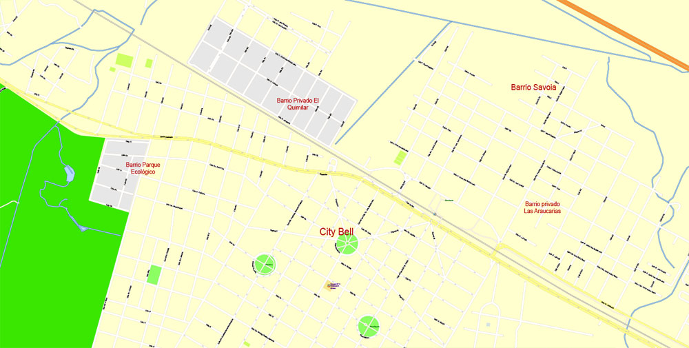
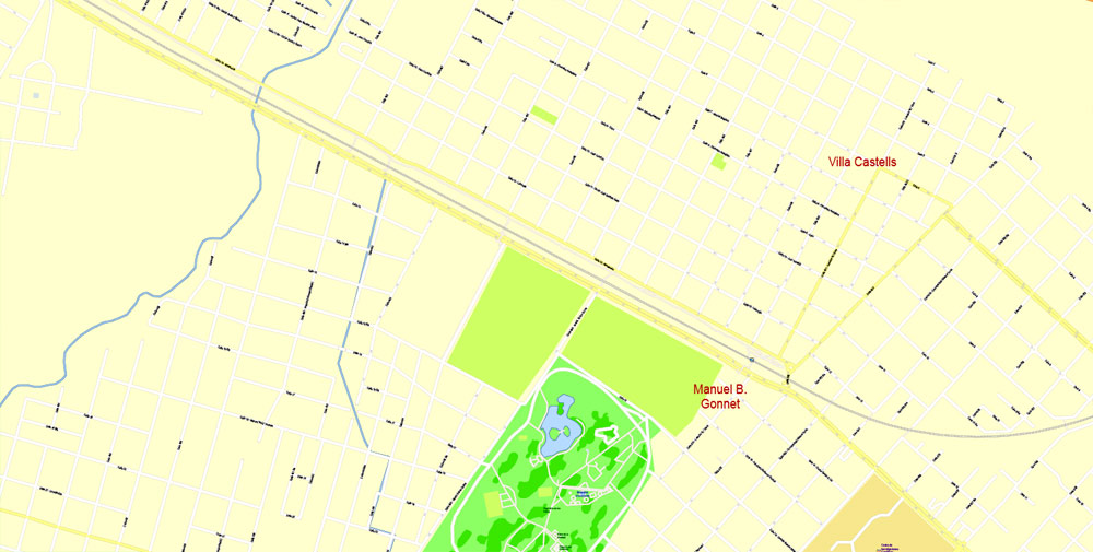
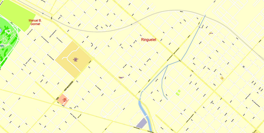
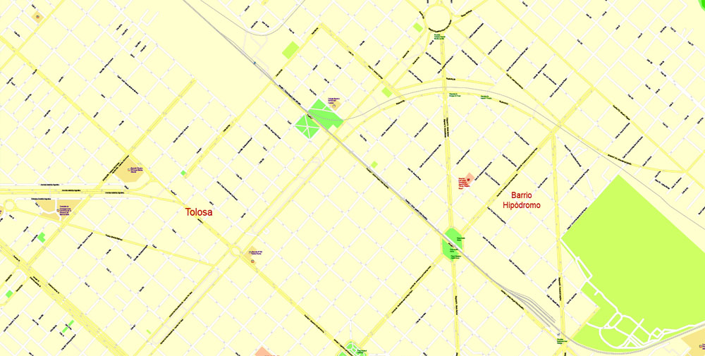
The metropolitan area of La Plata includes the neighborhoods of Tolosa, Ringuelet, Manuel B. Gonnet, City Bell, Villa Elisa, Melchor Romero, Abasto, Gorina, José Hernández, Ángel Etcheverry, Arturo Seguí, Los Hornos, Lisandro Olmos, Villa Elvira and Altos de San Lorenzo, all of which have community centers that operate as local delegations.
Color groups
Is a list of all saved color groups for current document (the same groups appear in the «Samples» palette). You can edit and delete the existing color groups, as well as creating a new ones using the list of “Color Groups” in the dialog box. All changes appear in the «Samples» palette.
The highlighted color group shows, which color group is currently edited.
Any color group can be selected and edited, or used to redefine the colors in the selected vector map of La Plata city, its fragments or elements.
Saving a color group adds this group to the specified list.
Opening the «Edit Colors»/«Repaint Graphic Object» dialog box.
Open the «Edit Colors»/«Repaint Graphic Object» dialog box using one of the following methods:
«Edit»> «Edit Colors»> «Repaint Graphic object» or «Repaint With Style».
Use these commands if you need to edit the colors in the selected vector map of La Plata city.
«Repaint Graphic object» button on the «Control» panel.
Use this button if you need to adjust colors of La Plata city vector map using the а «Repaint graphic object» dialog box.
The specified button is available if the selected vector map or its fragment contains two or more colors.
Note. This color editing method is convenient for global color adjustment in a vector map, if global colors were not used when creating a City Map of La Plata.
The «Edit colors» button or «Edit or apply colors» on the «Color Catalog» palette
Click this button if you need to edit colors on the «Color Catalog» palette or edit and then apply them to the selected Vector Map of La Plata city or its fragment.
The «Edit color group» button or «Edit or apply color group» on the «Samples» palette.
Click this button if you need to edit the colors in the specific color group or edit and apply them to the selected Vector Map of La Plata city or a group of its elements, for example, the whole layer “Streets and lines”. You can also double-click the color group in the Samples panel to open the dialog box.
If the map file is too large and your computer freezes or even can’t open it quickly:
1. Try to reduce the color resolution of the video card (display) to 256 colors while working with a large map.
2. Using Windows Task Manager, select all the application you don’t need, while working with map, just turn them off.
3. Launch Adobe Illustrator. (DO NOT OPEN the vector map file)
4. Start the Windows Task Manager using administrator rights > Find the “Illustrator” process > set the «real time» priority,
5. Open the file. When you see the LEGACY FONT popup window – click “OK” (do not update). You can restore the TEXT later.
6. Can also be useful: When file is opened – Edit > Settings > Basic Settings > disable smoothing. /// It looks scary, but works quickly)))
We recommend saving the file in Adobe Illustrator 10 version. It’s much more stable when working with VERY BIG size files.
La Plata
City in Argentina
La Plata is the capital of Argentina’s Buenos Aires province and is near the city of Buenos Aires. A planned city, it’s known for its distinctive diagonal avenues. At its center, the open expanse of Plaza Moreno is crowned by the grand, neo-Gothic Cathedral of La Plata. Also on the plaza is the Palacio Municipal, built in German Renaissance style. La Plata Museum has a vast collection of natural-history exhibits.
Area
• City 203 km2 (78.5 sq mi)
• Land 203 km2 (78.5 sq mi)
• Metro 4,758 km2 (1,837 sq mi)
Elevation 26 m (85 ft)
Population
• Urban 643,133
• Metro 899,523

 Author: Kirill Shrayber, Ph.D. FRGS