Printable Vector Map Denmark Admin, exact Mercator Projection, editable Layered Adobe Illustrator, 8 Mb ZIP.
Exact boundaries Country, Provinces and Counties with names. Map for publishing, design, printing, publications, arts, projects, presentations, for architects, designers and builders, business, logistics. The most accurate map of this level.
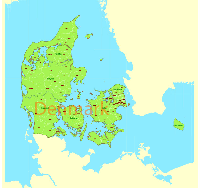
Layers: Ground_sea, Provinces, Names_provinces, Counties, Names_counties, Names_country, State_boundaries
Text format all names
DWG, DXF, CDR, ESRI Shapes, and other formats – by request, same price, please contact.
Denmark.
This vector map of Denmark is used as a basis for design, editing, and further printing.
This is the most detailed, exact map of Denmark for high-quality printing and polygraphy. You can always clarify the map development date by contacting us.
For your convenience, all objects on Denmark vector map are divided into layers. And the editing is very easy – colors, lines, etc.
You can easily add any objects needed (e.g. shops, salons, sale points, gas station or attraction) on any layer of Denmark vector map.
Denmark is a Nordic country and the southernmost of the Scandinavian nations. The sovereign state is south-west of Sweden and south of Norway, and bordered to the south by Germany. The Kingdom of Denmark also comprises two autonomous constituent countries in the North Atlantic Ocean: the Faroe Islands and Greenland. Denmark proper consists of a peninsula, Jutland, and an archipelago of 443 named islands, with the largest being Zealand, Funen and the North Jutlandic Island.
One of the advantages of Denmark vector maps of our production is the relevance of cartographic data, we constantly update all our products.
This vector map of Denmark is used by:
designers, layout designers, printers, advertisers and architects. Our product – vector maps – is designed for further editing and printing in large formats – from @Wall format (a few meters) to A-0 and A-1, A-2, A-3.
The Denmark map in vector format is used for design, urban planning, presentations and media visualizations.
The advertising and presentation map of Denmark (usually the final designer marks the routes, and puts the client’s objects (shops, saloons, gas stations etc.)
The undoubted advantage is that people will NEVER throw out this advertising product – the map. In fact, as an advertising medium, a map is the most “long-playing” of the well-known polygraphic advertising media, with the longest lifespan, and the maximum number of interactions with the customer.
For travelers, maps are sold at the airports and gas stations around the world. Often the source is our vector maps.
Take a look, who purchases our vector maps of Denmark in “Our Clients and Friends” page – these are large and small companies, from super-brands like Volvo and Starbucks, to small design studios and printing houses.
It’s very easy to work with vector maps of Denmark city, even for a not very experienced designer who can turn on and off the map layers, add new objects, change the colors of fill and lines according to customer requirements.
The undoubted advantage of Denmark vector maps in printing is an excellent and detailed visualization, when customer can expand a large paper map and instantly define his location, find a landmark, an object or address on map, unlike using the popular electronic formats of Google and Yandex maps for example.
Printable vector maps of Denmark are much more convenient and efficient than any electronic maps on your smartphone, because ALL DETAILS are displayed in the entire space of Denmark map.
Useful tips on working with vector maps of cities and countries in Adobe Illustrator.
«V» – launches the Selection tool (cursor, black arrow), which makes active any vector line.
«А» – launches the Direct Selection tool (white cursor), allows you to select curve elements and drag them to the desired place.
«R» – activates the Rotate tool, which helps you rotating selected objects around the center point by 360 degrees.
«E» – gives you the opportunity to use the Eraser tool and erase unnecessary parts.
«X» – switches between Fill and Stroke in the Tools section. Try to get used to this hot key and
you will quickly understand that you can’t live and work without it.
Guides are not limited to vertical and horizontal in Adobe Illustrator. You can also create a diagonal guide for example. Moreover, you can turn any contours into guides. Select the outline and go to View > Guides > Make Guides (Create Guides), or simply press Cmd/Ctrl + 5. You can also turn the guides back into an editable object. Go to menu, View > Guides > Unlock Guides (Release Guides), select the guide you want to edit and select View > Guides > Release Guides (Reset Guides), or just press Cmd/Ctrl + Option / Alt + 5).
You will probably want to change the color scheme used on our Denmark vector map.
To quickly and effectively play with colors.
Of course, you can do it manually, all objects in our Denmark vector map are divided according to types and layers, and you can easily change the color gamma of vector objects in groups and layers.
But there is more effective way of working with the whole VECTOR MAP of Denmark and all layers:
The overview dialog «Edit colors»/«Repaint Graphic Object» (this dialog box name can change depending on the context):
If you have selected a part or a layer of Denmark vector map and open the dialog box by clicking the icon in the Control panel, on the Samples palette or the Color Catalog, or if you choose Edit > Edit Colors> Repaint Graphic Object, then the «Repaint Graphic Object» dialog box appears, and you get access to «Assign» and «Edit» tabs.
If a picture or a map fragment is not selected, and you open the dialog box by clicking the icon in the Control panel, on the Samples palette or in the Color Catalog, the «Edit Colors» dialog box appears and you can only access the «Edit» tab.
Regardless of the name at the top of the dialog box, the right-hand side always displays the color group of the current document, as well as two default color groups: Print Color and Grayscale. These color groups can be selected and used any time.
Create and edit color groups of Denmark vector map, and also assign colors using the «Edit Colors»/ а «Repaint Graphic Object» dialog box.
A. Creating and editing of a color group on the «Edit» tab
B. Assigning colors on the «Assign» tab
C. Select a group of colors from the «Color groups» list
The option «Repaint a graphic object» in the lower part of the dialog box allows you to preview the colors on a selected layer of Vector map, or a group of elements, and specify whether its colors will be redefined when the dialog box is closed.
The main areas of the dialog box are:
«Edit»
The «Edit» tab is designed to create a new or edit the existing color groups.
The harmony rules Menu and the Color Wheel are used to conduct experiments with color harmonies. The color wheel shows how colors are related in color harmony, and the color bars allow you to view and manipulate an individual color values. In addition, you can adjust the brightness, add and remove colors, save color groups and view colors on the selected Vector Map of Denmark or a separated layers.
«Assign»
The «Assign» tab is used to view and control on how the original colors are replaced with colors from the color group like your corporate colors in the Vector Map of Denmark city.
The assign color ability is provided only if the entire map, layer or fragment is selected in the document. You can specify which of new colors replace the current colors, whether the spot colors should be preserved and how colors are replaced (for example, you can replace colors completely or changing the color tone while maintaining the brightness). The «Assign» tab allows you to redefine colors in the Vector Map of Denmark city, or in separate layers and fragments using the current color group or reducing the number of colors in the current Vector Map.
Color groups
Is a list of all saved color groups for current document (the same groups appear in the «Samples» palette). You can edit and delete the existing color groups, as well as creating a new ones using the list of “Color Groups” in the dialog box. All changes appear in the «Samples» palette.
The highlighted color group shows, which color group is currently edited.
Any color group can be selected and edited, or used to redefine the colors in the selected vector map of Denmark city, its fragments or elements.
Saving a color group adds this group to the specified list.
Opening the «Edit Colors»/«Repaint Graphic Object» dialog box.
Open the «Edit Colors»/«Repaint Graphic Object» dialog box using one of the following methods:
«Edit»> «Edit Colors»> «Repaint Graphic object» or «Repaint With Style».
Use these commands if you need to edit the colors in the selected vector map of Denmark city.
«Repaint Graphic object» button on the «Control» panel.
Use this button if you need to adjust colors of Denmark vector map using the а «Repaint graphic object» dialog box.
The specified button is available if the selected vector map or its fragment contains two or more colors.
Note. This color editing method is convenient for global color adjustment in a vector map, if global colors were not used when creating a Map of Denmark.
The «Edit colors» button or «Edit or apply colors» on the «Color Catalog» palette
Click this button if you need to edit colors on the «Color Catalog» palette or edit and then apply them to the selected Vector Map of Denmark or its fragment.
The «Edit color group» button or «Edit or apply color group» on the «Samples» palette.
Click this button if you need to edit the colors in the specific color group or edit and apply them to the selected Vector Map of Denmark or a group of its elements, for example, the whole layer “Streets and lines”. You can also double-click the color group in the Samples panel to open the dialog box.
If the map file is too large and your computer freezes or even can’t open it quickly:
1. Try to reduce the color resolution of the video card (display) to 256 colors while working with a large map.
2. Using Windows Task Manager, select all the application you don’t need, while working with map, just turn them off.
3. Launch Adobe Illustrator. (DO NOT OPEN the vector map file)
4. Start the Windows Task Manager using administrator rights > Find the “Illustrator” process > set the «real time» priority,
5. Open the file. When you see the LEGACY FONT popup window – click “OK” (do not update). You can restore the TEXT later.
6. Can also be useful: When file is opened – Edit > Settings > Basic Settings > disable smoothing. /// It looks scary, but works quickly)))
We recommend saving the file in Adobe Illustrator 10 version. It’s much more stable when working with VERY BIG size files.
The islands are characterised by flat, arable land and sandy coasts, low elevation and a temperate climate. Denmark has a total area of 42,924 km2 (16,573 sq mi), land area of 42,394 km2 (16,368 sq mi), and the total area including Greenland and the Faroe Islands is 2,210,579 km2 (853,509 sq mi), and a population of 5.8 million (as of 2018).
The unified kingdom of Denmark emerged in the 10th century as a proficient seafaring nation in the struggle for control of the Baltic Sea. Denmark, Sweden, and Norway were ruled together under one sovereign ruler in the Kalmar Union, established in 1397 and ending with Swedish secession in 1523. The areas of Denmark and Norway remained under the same monarch until 1814, often referred to as the Dano-Norwegian Realm, or simply Denmark-Norway. Beginning in the 17th century, there were several devastating wars with the Swedish Empire, ending with large cessions of territory to Sweden. After the Napoleonic Wars, Norway was ceded to Sweden, while Denmark kept the Faroe Islands, Greenland, and Iceland. In the 19th century there was a surge of nationalist movements, which were defeated in the 1864 Second Schleswig War. Denmark remained neutral during World War I. In April 1940, a German invasion saw brief military skirmishes while the Danish resistance movement was active from 1943 until the German surrender in May 1945. An industrialised exporter of agricultural produce in the second half of the 19th century, Denmark introduced social and labour-market reforms in the early 20th century that created the basis for the present welfare state model with a highly developed mixed economy.
The Constitution of Denmark was signed on 5 June 1849, ending the absolute monarchy, which had begun in 1660. It establishes a constitutional monarchy organised as a parliamentary democracy. The government and national parliament are seated in Copenhagen, the nation’s capital, largest city, and main commercial centre. Denmark exercises hegemonic influence in the Danish Realm, devolving powers to handle internal affairs. Home rule was established in the Faroe Islands in 1948; in Greenland home rule was established in 1979 and further autonomy in 2009. Denmark became a member of the European Economic Community (now the EU) in 1973, but has later negotiated certain opt-outs; it retains its own currency, the krone. It is among the founding members of NATO, the Nordic Council, the OECD, OSCE, and the United Nations; it is also part of the Schengen Area.
Denmark is considered to be one of the most economically and socially developed countries in the world. Danes enjoy a high standard of living and the country ranks highly in some metrics of national performance, including education, health care, protection of civil liberties, democratic governance, prosperity, and human development. The country ranks as having the world’s highest social mobility, a high level of income equality, is the country with the lowest perceived level of corruption in the world, the eleventh-most developed in the world, has one of the world’s highest per capita incomes, and one of the world’s highest personal income tax rates.
Geography
Located in Northern Europe, Denmark consists of the peninsula of Jutland and 443 named islands (1,419 islands above 100 square metres (1,100 sq ft) in total). Of these, 74 are inhabited (January 2015), with the largest being Zealand, the North Jutlandic Island, and Funen. The island of Bornholm is located east of the rest of the country, in the Baltic Sea. Many of the larger islands are connected by bridges; the Øresund Bridge connects Zealand with Sweden; the Great Belt Bridge connects Funen with Zealand; and the Little Belt Bridge connects Jutland with Funen. Ferries or small aircraft connect to the smaller islands. The four cities with populations over 100,000 are the capital Copenhagen on Zealand; Aarhus and Aalborg in Jutland; and Odense on Funen.
The country occupies a total area of 42,924 square kilometres (16,573 sq mi) The area of inland water is 700 km2 (270 sq mi), variously stated as from 500 – 700 km2 (193–270 sq mi). Lake Arresø northwest of Copenhagen is the largest lake. The size of the land area cannot be stated exactly since the ocean constantly erodes and adds material to the coastline, and because of human land reclamation projects (to counter erosion). Post-glacial rebound raises the land by a bit less than 1 cm (0.4 in) per year in the north and east, extending the coast. A circle enclosing the same area as Denmark would be 234 kilometres (145 miles) in diameter with a circumference of 742 km (461 mi). It shares a border of 68 kilometres (42 mi) with Germany to the south and is otherwise surrounded by 8,750 km (5,437 mi) of tidal shoreline (including small bays and inlets). No location in Denmark is farther from the coast than 52 km (32 mi). On the south-west coast of Jutland, the tide is between 1 and 2 m (3.28 and 6.56 ft), and the tideline moves outward and inward on a 10 km (6.2 mi) stretch. Denmark’s territorial waters total 105,000 square kilometres (40,541 square miles).
Denmark’s northernmost point is Skagen’s point (the north beach of the Skaw) at 57° 45′ 7″ northern latitude; the southernmost is Gedser point (the southern tip of Falster) at 54° 33′ 35″ northern latitude; the westernmost point is Blåvandshuk at 8° 4′ 22″ eastern longitude; and the easternmost point is Østerskær at 15° 11′ 55″ eastern longitude. This is in the archipelago Ertholmene 18 kilometres (11 mi) north-east of Bornholm. The distance from east to west is 452 kilometres (281 mi), from north to south 368 kilometres (229 mi).
Bay of Aarhus viewed from southern Djursland
The country is flat with little elevation, having an average height above sea level of 31 metres (102 ft). The highest natural point is Møllehøj, at 170.86 metres (560.56 ft). A sizeable portion of Denmark’s terrain consists of rolling plains whilst the coastline is sandy, with large dunes in northern Jutland. Although once extensively forested, today Denmark largely consists of arable land. It is drained by a dozen or so rivers, and the most significant include the Gudenå, Odense, Skjern, Suså and Vidå—a river that flows along its southern border with Germany.
The Kingdom of Denmark includes two overseas territories, both well to the west of Denmark: Greenland, the world’s largest island, and the Faroe Islands in the North Atlantic Ocean. These territories are self-governing and form part of the Danish Realm.
Denmark is a Nordic country located in Northern Europe. It consists of the Jutland peninsula and several islands in the Baltic sea, referred to as the Danish Archipelago. Denmark is located southwest of Sweden and due south of Norway and is bordered by the German state (and former possession) Schleswig-Holstein to the south, on Denmark’s only land border, 68 kilometres (42 miles) long.
Denmark borders both the Baltic and North Seas along its 8,750 km (5,440 mi) tidal shoreline. Denmark’s general coastline is much shorter, at 1,701 km (1,057 mi), as it would not include most of the 1,419 offshore islands (each defined as exceeding 100 square meters in area) and the 180 km long Limfjorden, which separates Denmark’s second largest island, North Jutlandic Island, 4,686 km2 in size, from the rest of Jutland. No location in Denmark is further from the coast than 52 km (32 mi). The size of the land area of Denmark cannot be stated exactly since the ocean constantly erodes and adds material to the coastline, and because of human land reclamation projects (to counter erosion). On the southwest coast of Jutland, the tide is between 1 and 2 m (3.28 and 6.56 ft), and the tideline moves outward and inward on a 10 km (6.2 mi) stretch.
A circle enclosing the same area as Denmark would be 742 km (461 miles) long. Denmark has 443 named islands (1,419 islands above 100 m²), of which 72 are inhabited (as of 1 January 2007, Statistics Denmark). The largest islands are Zealand (Sjælland) and Funen (Fyn). The island of Bornholm is located east of the rest of the country, in the Baltic Sea. Many of the larger islands are connected by bridges; the Øresund Bridge connects Zealand with Sweden; the Great Belt Bridge connects Funen with Zealand; and the Little Belt Bridge connects Jutland with Funen. Ferries or small aircraft connect to the smaller islands. Main cities are the capital Copenhagen on Zealand; Århus, Aalborg and Esbjerg in Jutland; and Odense on Funen.
Denmark experiences a temperate climate. This means that the winters are mild and windy and the summers are cool. The local terrain is generally flat with a few gently rolling plains. The territory of Denmark includes the island of Bornholm in the Baltic Sea and the rest of metropolitan Denmark, but excludes the Faroe Islands and Greenland. Its position gives Denmark complete control of the Danish Straits (Skagerrak and Kattegat) linking the Baltic and North Seas. The country’s natural resources include petroleum, natural gas, fish, salt, limestone, chalk, stone, gravel and sand.
Denmark
Country in Europe
Denmark is a Scandinavian country comprising the Jutland Peninsula and numerous islands. It’s linked to nearby Sweden via the Öresund bridge. Copenhagen, its capital, is home to royal palaces and colorful Nyhavn harbor, plus the Tivoli amusement park and the iconic “Little Mermaid” statue. Odense is writer Hans Christian Andersen’s hometown, with a medieval core of cobbled streets and half-timbered houses.
Capital: Copenhagen
Free vector maps:

Free download printable map Europe vector Adobe Illustrator >>>
Free download printable PDF map Europe vector Adobe PDF >>>

 Author: Kirill Shrayber, Ph.D. FRGS


