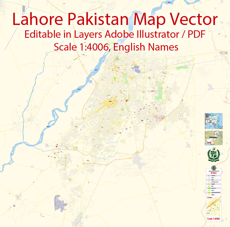
Printable PDF Vector Map of Lahore Pakistan EN detailed City Plan scale 1:4006 full editable Adobe PDF Street Map in layers , scalable, editable text format all names, 20 mb ZIP
English streets names, Main Objects, Buildings. Map for design, printing, arts, projects, presentations, for architects, designers and builders, business, logistics.
Layers: color_fills, streets_roads, labels_roads, names_objects, names_streets, names_places, grids, legend.
The most exact and detailed map of the city in scale.
For Editing and High Quality Printing
DWG, DXF and other formats – on request, same price, please, contact
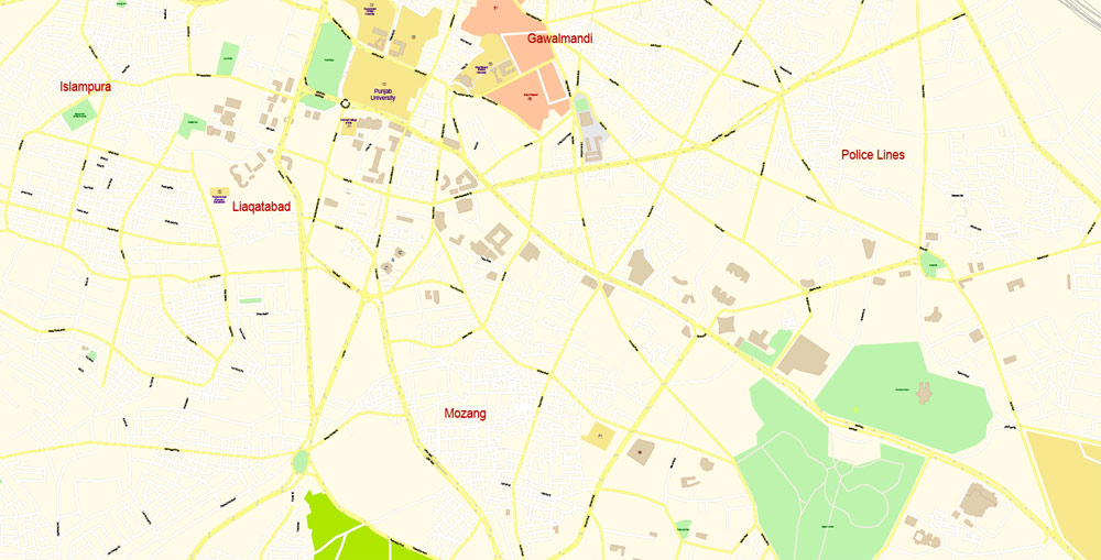
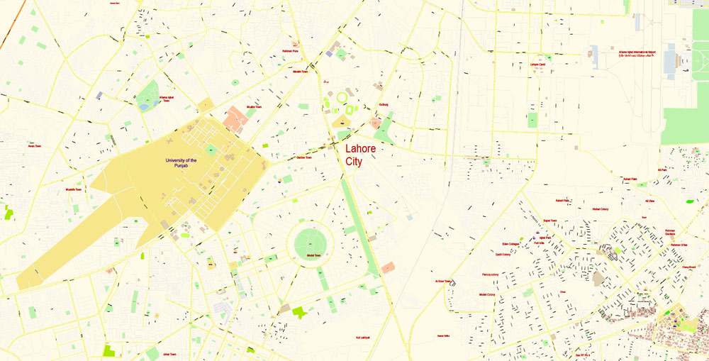
Lahore
City in Pakistan
Lahore is the capital city of the Pakistani province of Punjab, and is the country’s second-most populous city after Lahore. The city is located in the north-eastern end of Pakistan’s Punjab province.
Lahore exerts a strong cultural influence over Pakistan. Lahore is a major centre for Pakistan’s publishing industry, and remains the foremost centre of Pakistan’s literary scene. The city is home to the annual Lahore Literary Festival, considered to be one of South Asia’s premier cultural events. The city is also a major centre of education in Pakistan, with some of Pakistan’s leading universities based in the city. Lahore is also home to Pakistan’s film industry, Lollywood, and is a major centre of Qawwali music. The city also hosts much of Pakistan’s tourist industry, with major attractions including the famed Walled City, numerous Sikh shrines, and the Badshahi and Wazir Khan mosques. Lahore is also home to the Lahore Fort and Shalimar Gardens, both of which are UNESCO World Heritage Sites.
This is the most detailed, exact map of Lahore city for high-quality printing and polygraphy. You can always clarify the map development date by contacting us.
Lahore is the historic cultural centre of the Punjab region as well as the broader Indian subcontinent, and is one of Pakistan’s most socially liberal, progressive, and cosmopolitan cities.
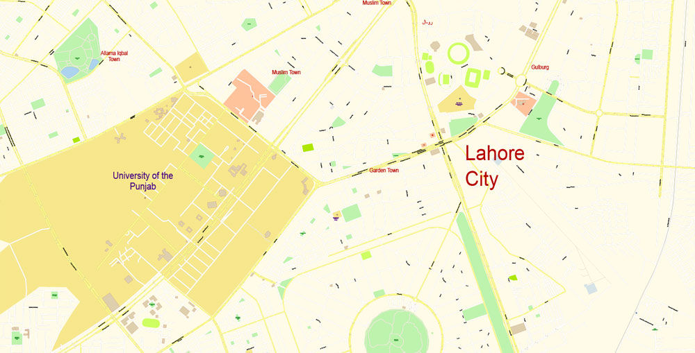
Printable vector maps of Lahore city are much more convenient and efficient than any electronic maps on your smartphone, because ALL DETAILS are displayed in the entire space of Lahore city map.
Useful tips on working with vector maps of cities and countries in Adobe Illustrator.
«V» – launches the Selection tool (cursor, black arrow), which makes active any vector line.
«А» – launches the Direct Selection tool (white cursor), allows you to select curve elements and drag them to the desired place.
«R» – activates the Rotate tool, which helps you rotating selected objects around the center point by 360 degrees.
«E» – gives you the opportunity to use the Eraser tool and erase unnecessary parts.
«X» – switches between Fill and Stroke in the Tools section. Try to get used to this hot key and
you will quickly understand that you can’t live and work without it.
This vector map of Lahore city is used as a basis for design, editing, and further printing.
Lahore’s origins reach into antiquity. The city has been controlled by numerous empires throughout the course of its history, including the Hindu Shahis, Ghaznavids, Ghurids, and Delhi Sultanate by the medieval era. Lahore reached the height of its splendour under the Mughal Empire between the late 16th and early 18th century, and served as its capital city for a number of years. The city was captured by the forces of Persian Emperor Nader Shah in 1739, and fell into a period of decay while being contested between different powers.
The Lahore city map in vector format is used for design, urban planning, presentations and media visualizations.
Lahore eventually became capital of the Sikh Empire in the early 19th century, and regained much of its lost grandeur. Lahore was then annexed to the British Empire, and made capital of British Punjab. Lahore was central to the independence movements of both India and Pakistan, with the city being the site of both the declaration of Indian Independence, and the resolution calling for the establishment of Pakistan. Lahore experienced some of the worst rioting during the Partition period preceding Pakistan’s independence.
The undoubted advantage of Lahore city vector maps in printing is an excellent and detailed visualization, when customer can expand a large paper map and instantly define his location, find a landmark, an object or address on map, unlike using the popular electronic formats of Google and Yandex maps for example.
Following independence in 1947, Lahore was declared capital of Pakistan’s Punjab province. It is also the largest city of the entire Punjab region of both Pakistan and India.
Lahore exerts a strong cultural influence over Pakistan. Lahore is a major centre for Pakistan’s publishing industry, and remains the foremost centre of Pakistan’s literary scene. The city is home to the annual Lahore Literary Festival, considered to be one of South Asia’s premier cultural events. It’s very easy to work with vector maps of Lahore city, even for a not very experienced designer who can turn on and off the map layers, add new objects, change the colors of fill and lines according to customer requirements.
Take a look, who purchases our vector maps of Lahore city in “Our Clients and Friends” page – these are large and small companies, from super-brands like Volvo and Starbucks, to small design studios and printing houses.
The city is also a major centre of education in Pakistan, with some of Pakistan’s leading universities based in the city. Lahore is also home to Pakistan’s film industry, Lollywood, and is a major centre of Qawwali music. The city also hosts much of Pakistan’s tourist industry, with major attractions including the famed Walled City, numerous Sikh shrines, and the Badshahi and Wazir Khan mosques. Lahore is also home to the Lahore Fort and Shalimar Gardens, both of which are UNESCO World Heritage Sites.
Color groups
Is a list of all saved color groups for current document (the same groups appear in the «Samples» palette). You can edit and delete the existing color groups, as well as creating a new ones using the list of “Color Groups” in the dialog box. All changes appear in the «Samples» palette.
The highlighted color group shows, which color group is currently edited.
Any color group can be selected and edited, or used to redefine the colors in the selected vector map of Lahore city, its fragments or elements.
Geography
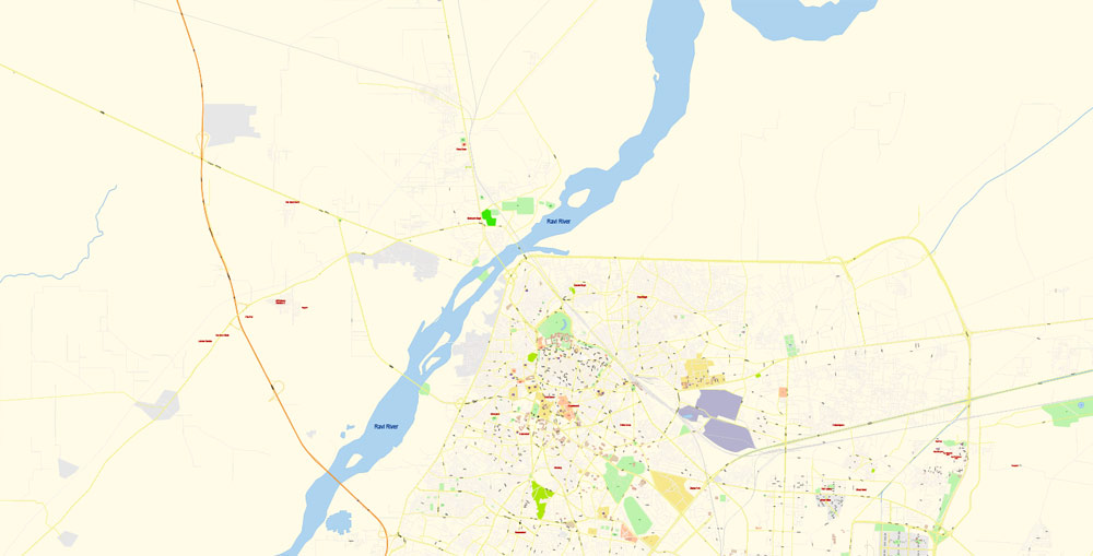
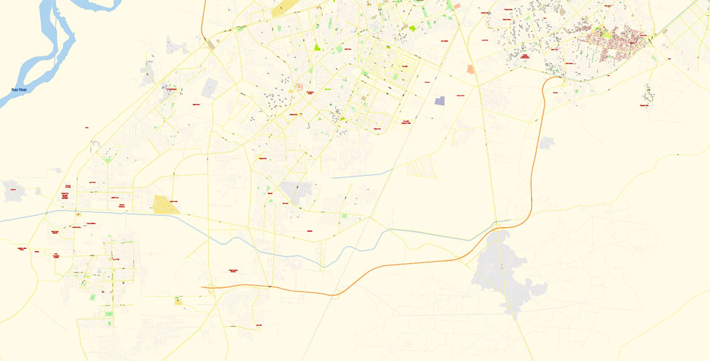
Lying between 31°15′—31°45′ N and 74°01′—74°39′ E, Lahore is bounded on the north and west by the Sheikhupura District, on the east by Wagah, and on the south by Kasur District. This vector map of Lahore city is used by:
designers, layout designers, printers, advertisers and architects. Our product – vector maps – is designed for further editing and printing in large formats – from @Wall format (a few meters) to A-0 and A-1, A-2, A-3.
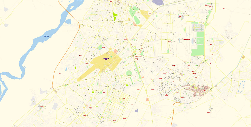
The Ravi River flows on the northern side of Lahore. Lahore city covers a total land area of 404 square kilometres (156 sq mi).
You will probably want to change the color scheme used on our Lahore vector city map.
To quickly and effectively play with colors.
Of course, you can do it manually, all objects in our Lahore city vector map are divided according to types and layers, and you can easily change the color gamma of vector objects in groups and layers.
Cityscape
Urban form
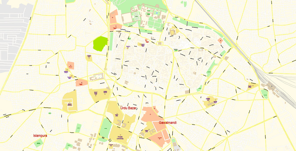
Lahore’s modern cityscape consists of the historic Walled City of Lahore in the northern part of the city, which contains several world and national heritage sites. Lahore’s urban planning was not based on geometric design, but was instead built piecemeal, with small cul-de-sacs, katrahs and galis developed in the context of neighbouring buildings. Though certain neighbourhoods were named for particular religious or ethnic communities, the neighbourhoods themselves typically were diverse, and were not dominated by the namesake group.
If a picture or a map fragment is not selected, and you open the dialog box by clicking the icon in the Control panel, on the Samples palette or in the Color Catalog, the «Edit Colors» dialog box appears and you can only access the «Edit» tab.
Saving a color group adds this group to the specified list.
Opening the «Edit Colors»/«Repaint Graphic Object» dialog box.
Open the «Edit Colors»/«Repaint Graphic Object» dialog box using one of the following methods:
«Edit»> «Edit Colors»> «Repaint Graphic object» or «Repaint With Style».
Use these commands if you need to edit the colors in the selected vector map of Lahore city.
Regardless of the name at the top of the dialog box, the right-hand side always displays the color group of the current document, as well as two default color groups: Print Color and Grayscale. These color groups can be selected and used any time.
Create and edit color groups of Lahore city vector map, and also assign colors using the «Edit Colors»/ а «Repaint Graphic Object» dialog box.
Lahore has more Mughal-era monuments than Delhi, India, and structures from this era are now amongst the most iconic features of Lahore.
Note. This color editing method is convenient for global color adjustment in a vector map, if global colors were not used when creating a City Map of Lahore.
By the end of Sikh rule, most of Lahore’s massive haveli compounds had been occupied by settlers. New neighbourhoods occasionally grew up entirely within the confines of an old Mughal haveli, such as the Mohallah Pathran Wali, which grew within the ruins of a haveli of the same name that was built by Mian Khan.
You can easily add any objects needed (e.g. shops, salons, sale points, gas station or attraction) on any layer of Lahore vector map.
By 1831, all Mughal havelis in the Walled City had been encroached upon by the surrounding neighbourhood, leading to the modern-day absence of any Mughal havelis in Lahore. One of the advantages of Lahore city vector maps of our production is the relevance of cartographic data, we constantly update all our products.
Thirteen gates surrounded the history walled city. Some of the remaining gates include the Raushnai Gate, Masti Gate, Yakki Gate, Kashmiri Gate, Khizri Gate, Shah Burj Gate, Akbari Gate and Lahori Gate. Southeast of the walled city is the spacious British-era Lahore Cantonment.
The advertising and presentation map of Lahore city (usually the final designer marks the routes, and puts the client’s objects (shops, saloons, gas stations etc.)
For travelers, maps are sold at the airports and gas stations around the world. Often the source is our vector maps.
Guides are not limited to vertical and horizontal in Adobe Illustrator. You can also create a diagonal guide for example. Moreover, you can turn any contours into guides. Select the outline and go to View > Guides > Make Guides (Create Guides), or simply press Cmd/Ctrl + 5. You can also turn the guides back into an editable object. Go to menu, View > Guides > Unlock Guides (Release Guides), select the guide you want to edit and select View > Guides > Release Guides (Reset Guides), or just press Cmd/Ctrl + Option / Alt + 5).
A. Creating and editing of a color group on the «Edit» tab
B. Assigning colors on the «Assign» tab
C. Select a group of colors from the «Color groups» list
The option «Repaint a graphic object» in the lower part of the dialog box allows you to preview the colors on a selected layer of Vector map, or a group of elements, and specify whether its colors will be redefined when the dialog box is closed.
The main areas of the dialog box are:
«Edit»
The «Edit» tab is designed to create a new or edit the existing color groups.
The harmony rules Menu and the Color Wheel are used to conduct experiments with color harmonies. The color wheel shows how colors are related in color harmony, and the color bars allow you to view and manipulate an individual color values. In addition, you can adjust the brightness, add and remove colors, save color groups and view colors on the selected Vector Map of Lahore city or a separated layers.
Assign
The «Assign» tab is used to view and control on how the original colors are replaced with colors from the color group like your corporate colors in the Vector Map of Lahore city.
The assign color ability is provided only if the entire map, layer or fragment is selected in the document. You can specify which of new colors replace the current colors, whether the spot colors should be preserved and how colors are replaced (for example, you can replace colors completely or changing the color tone while maintaining the brightness). The «Assign» tab allows you to redefine colors in the Vector Map of Lahore city, or in separate layers and fragments using the current color group or reducing the number of colors in the current Vector Map.
The undoubted advantage is that people will NEVER throw out this advertising product – the map. In fact, as an advertising medium, a city map is the most “long-playing” of the well-known polygraphic advertising media, with the longest lifespan, and the maximum number of interactions with the customer.
Parks and gardens
The Shalimar Gardens were laid out during the reign of Shah Jahan and were designed to mimic the Islamic paradise of the afterlife described in the Qur’an.
For your convenience, all objects on Lahore vector city map are divided into layers. And the editing is very easy – colors, lines, etc.
The gardens follow the familiar charbagh layout of four squares, with three descending terraces.
The Lawrence Garden was established in 1862 and was originally named after Sir John Lawrence, late 19th-century British Viceroy to India. The Circular Garden, which surrounds on the Walled City on three sides, was established by 1892.
«Repaint Graphic object» button on the «Control» panel.
Use this button if you need to adjust colors of Lahore city vector map using the а «Repaint graphic object» dialog box.
The specified button is available if the selected vector map or its fragment contains two or more colors.
The many other gardens and parks in the city include Hazuri Bagh, Iqbal Park, Mochi Bagh, Gulshan-e-Iqbal Park, Model Town Park, Race Course Park, Nasir Bagh Lahore, Jallo Park, Lahore Zoo Safari Park, and Changa Manga, a man-made forest near Lahore in the Kasur district. Another example is the Bagh-e-Jinnah, a 141-acre (57 ha) botanical garden that houses entertainment and sports facilities as well as a library.
But there is more effective way of working with the whole VECTOR MAP of Lahore city and all layers:
The overview dialog «Edit colors»/«Repaint Graphic Object» (this dialog box name can change depending on the context):
If you have selected a part or a layer of Lahore city vector map and open the dialog box by clicking the icon in the Control panel, on the Samples palette or the Color Catalog, or if you choose Edit > Edit Colors> Repaint Graphic Object, then the «Repaint Graphic Object» dialog box appears, and you get access to «Assign» and «Edit» tabs.
Click this button if you need to edit the colors in the specific color group or edit and apply them to the selected Vector Map of Lahore city or a group of its elements, for example, the whole layer “Streets and lines”. You can also double-click the color group in the Samples panel to open the dialog box.
If the map file is too large and your computer freezes or even can’t open it quickly:
1. Try to reduce the color resolution of the video card (display) to 256 colors while working with a large map.
2. Using Windows Task Manager, select all the application you don’t need, while working with map, just turn them off.
3. Launch Adobe Illustrator. (DO NOT OPEN the vector map file)
4. Start the Windows Task Manager using administrator rights > Find the “Illustrator” process > set the «real time» priority,
5. Open the file. When you see the LEGACY FONT popup window – click “OK” (do not update). You can restore the TEXT later.
6. Can also be useful: When file is opened – Edit > Settings > Basic Settings > disable smoothing. /// It looks scary, but works quickly)))
We recommend saving the file in Adobe Illustrator 10 version. It’s much more stable when working with VERY BIG size files.
Area
• Total 1,772 km2 (684 sq mi)
Elevation 217 m (712 ft)
Population
• Total 11,126,285
• Density 6,300/km2 (16,000/sq mi)
Free vector map World, Adobe Illustrator, download now maps vector clipart
Map for design, projects, presentation free to use as you like.
See also: TERMS & CONDITIONS: SOFTWARE LICENSE AGREEMENT FOR DIGITAL CARTOGRAPHIC DATA.
Need more USA Vector Maps, printable and editable?

 Author: Kirill Shrayber, Ph.D. FRGS
