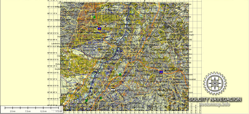
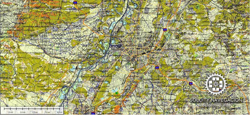
Karlsruhe vector map Atlas 100 parts. Germany, Europe
Archive size: 119 Mb, zipped .AI
DPI: 300
License: Royalty Free
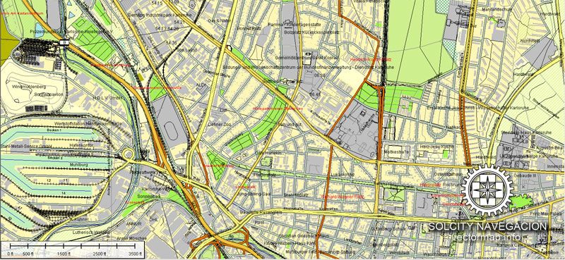
Karlsruhe (Germany) vector maps in Adobe Illustrator format (.AI) features (check the preview images):
Highways with names,
Major streets with names,
Major Roads,
Dam,
National Park Borders,
Minor Roads,
Big and small Rivers, small streams also,
Lake, ponds and other water bodies,
Landmark fill,
Houses,
Railway
Recreation zones,
Parks.
We provide detailed maps of Karlsruhe (Deutschland) in AI. Being vector maps, they are completely editable, and scalable. No matter what big is the print size you need (office wall mural o bigboard). This vector maps of Karlsruhe are fully customisable, you can turn on or off the layer you need, also complete map with objects needed, like your company logo for example.
Please also check other vector maps of Germany.
Karlsruhe, Germany.
This vector map of Karlsruhe city is used as a basis for design, editing, and further printing.
This is the most detailed, exact map of Karlsruhe city for high-quality printing and polygraphy. You can always clarify the map development date by contacting us.
For your convenience, all objects on Karlsruhe vector city map are divided into layers. And the editing is very easy – colors, lines, etc.
You can easily add any objects needed (e.g. shops, salons, sale points, gas station or attraction) on any layer of Karlsruhe vector map.
Karlsruhe is the second-largest city of the German federal state of Baden-Württemberg after its capital of Stuttgart, and its 309,999 (2016) inhabitants make it the 21st largest city of Germany. On the right bank of the Rhine, the city lies near the French-German border, between the Mannheim/Ludwigshafen conurbation to the north, and the Strasbourg/Kehl conurbation to the south. It is the largest city of Baden, a region named after Hohenbaden Castle in the city of Baden-Baden. Karlsruhe is also the largest city in the South Franconian dialect area (transitional dialects between Central and Upper German), the only other larger city in that area being Heilbronn.
One of the advantages of Karlsruhe city vector maps of our production is the relevance of cartographic data, we constantly update all our products.
This vector map of Karlsruhe city is used by:
designers, layout designers, printers, advertisers and architects. Our product – vector maps – is designed for further editing and printing in large formats – from @Wall format (a few meters) to A-0 and A-1, A-2, A-3.
The Karlsruhe city map in vector format is used for design, urban planning, presentations and media visualizations.
The advertising and presentation map of Karlsruhe city (usually the final designer marks the routes, and puts the client’s objects (shops, saloons, gas stations etc.)
The undoubted advantage is that people will NEVER throw out this advertising product – the map. In fact, as an advertising medium, a city map is the most “long-playing” of the well-known polygraphic advertising media, with the longest lifespan, and the maximum number of interactions with the customer.
For travelers, maps are sold at the airports and gas stations around the world. Often the source is our vector maps.
Take a look, who purchases our vector maps of Karlsruhe city in “Our Clients and Friends” page – these are large and small companies, from super-brands like Volvo and Starbucks, to small design studios and printing houses.
It’s very easy to work with vector maps of Karlsruhe city, even for a not very experienced designer who can turn on and off the map layers, add new objects, change the colors of fill and lines according to customer requirements.
The undoubted advantage of Karlsruhe city vector maps in printing is an excellent and detailed visualization, when customer can expand a large paper map and instantly define his location, find a landmark, an object or address on map, unlike using the popular electronic formats of Google and Yandex maps for example.
Printable vector maps of Karlsruhe city are much more convenient and efficient than any electronic maps on your smartphone, because ALL DETAILS are displayed in the entire space of Karlsruhe city map.
Useful tips on working with vector maps of cities and countries in Adobe Illustrator.
«V» – launches the Selection tool (cursor, black arrow), which makes active any vector line.
«А» – launches the Direct Selection tool (white cursor), allows you to select curve elements and drag them to the desired place.
«R» – activates the Rotate tool, which helps you rotating selected objects around the center point by 360 degrees.
«E» – gives you the opportunity to use the Eraser tool and erase unnecessary parts.
«X» – switches between Fill and Stroke in the Tools section. Try to get used to this hot key and
you will quickly understand that you can’t live and work without it.
Guides are not limited to vertical and horizontal in Adobe Illustrator. You can also create a diagonal guide for example. Moreover, you can turn any contours into guides. Select the outline and go to View > Guides > Make Guides (Create Guides), or simply press Cmd/Ctrl + 5. You can also turn the guides back into an editable object. Go to menu, View > Guides > Unlock Guides (Release Guides), select the guide you want to edit and select View > Guides > Release Guides (Reset Guides), or just press Cmd/Ctrl + Option / Alt + 5).
You will probably want to change the color scheme used on our Karlsruhe vector city map.
To quickly and effectively play with colors.
Of course, you can do it manually, all objects in our Karlsruhe city vector map are divided according to types and layers, and you can easily change the color gamma of vector objects in groups and layers.
But there is more effective way of working with the whole VECTOR MAP of Karlsruhe city and all layers:
The overview dialog «Edit colors»/«Repaint Graphic Object» (this dialog box name can change depending on the context):
If you have selected a part or a layer of Karlsruhe city vector map and open the dialog box by clicking the icon in the Control panel, on the Samples palette or the Color Catalog, or if you choose Edit > Edit Colors> Repaint Graphic Object, then the «Repaint Graphic Object» dialog box appears, and you get access to «Assign» and «Edit» tabs.
The city is the seat of the Federal Constitutional Court (Bundesverfassungsgericht), as well as of the Federal Court of Justice (Bundesgerichtshof) and the Public Prosecutor General of the Federal Court of Justice (Generalbundesanwalt beim Bundesgerichtshof).
If a picture or a map fragment is not selected, and you open the dialog box by clicking the icon in the Control panel, on the Samples palette or in the Color Catalog, the «Edit Colors» dialog box appears and you can only access the «Edit» tab.
Regardless of the name at the top of the dialog box, the right-hand side always displays the color group of the current document, as well as two default color groups: Print Color and Grayscale. These color groups can be selected and used any time.
Create and edit color groups of Karlsruhe city vector map, and also assign colors using the «Edit Colors»/ а «Repaint Graphic Object» dialog box.
A. Creating and editing of a color group on the «Edit» tab
B. Assigning colors on the «Assign» tab
C. Select a group of colors from the «Color groups» list
The option «Repaint a graphic object» in the lower part of the dialog box allows you to preview the colors on a selected layer of Vector map, or a group of elements, and specify whether its colors will be redefined when the dialog box is closed.
Karlsruhe was the capital of the Margraviate of Baden-Durlach (Durlach: 1565-1718; Karlsruhe: 1718-1771), the Margraviate of Baden (1771-1803), the Electorate of Baden (1803-1806), the Grand Duchy of Baden (1806-1918), and the Republic of Baden (1918-1945). Its most remarkable building is Karlsruhe Palace, which was built in 1715. There are nine institutions of higher education in the city, most notably the Karlsruhe Institute of Technology (Karlsruher Institut für Technologie). Karlsruhe/Baden-Baden Airport (Flughafen Karlsruhe/Baden-Baden) is the second-busiest airport of Baden-Württemberg after Stuttgart Airport, and the 17th-busiest airport of Germany.
The main areas of the dialog box are:
«Edit»
The «Edit» tab is designed to create a new or edit the existing color groups.
The harmony rules Menu and the Color Wheel are used to conduct experiments with color harmonies. The color wheel shows how colors are related in color harmony, and the color bars allow you to view and manipulate an individual color values. In addition, you can adjust the brightness, add and remove colors, save color groups and view colors on the selected Vector Map of Karlsruhe city or a separated layers.
«Assign»
The «Assign» tab is used to view and control on how the original colors are replaced with colors from the color group like your corporate colors in the Vector Map of Karlsruhe city.
The assign color ability is provided only if the entire map, layer or fragment is selected in the document. You can specify which of new colors replace the current colors, whether the spot colors should be preserved and how colors are replaced (for example, you can replace colors completely or changing the color tone while maintaining the brightness). The «Assign» tab allows you to redefine colors in the Vector Map of Karlsruhe city, or in separate layers and fragments using the current color group or reducing the number of colors in the current Vector Map.
Karlsruhe lies completely to the east of the Rhine, and almost completely on the Upper Rhine Plain. It contains the Turmberg in the east, and also lies on the borders of the Kraichgau leading to the Northern Black Forest.
Color groups
Is a list of all saved color groups for current document (the same groups appear in the «Samples» palette). You can edit and delete the existing color groups, as well as creating a new ones using the list of “Color Groups” in the dialog box. All changes appear in the «Samples» palette.
The highlighted color group shows, which color group is currently edited.
Any color group can be selected and edited, or used to redefine the colors in the selected vector map of Karlsruhe city, its fragments or elements.
Saving a color group adds this group to the specified list.
Opening the «Edit Colors»/«Repaint Graphic Object» dialog box.
Open the «Edit Colors»/«Repaint Graphic Object» dialog box using one of the following methods:
«Edit»> «Edit Colors»> «Repaint Graphic object» or «Repaint With Style».
The Rhine, one of the world’s most important shipping routes, forms the western limits of the city, beyond which lie the towns of Maximiliansau and Wörth am Rhein in the German state of Rhineland-Palatinate. The city centre is about 7.5 km (4.7 mi) from the river, as measured from the Marktplatz (Market Square). Two tributaries of the Rhine, the Alb and the Pfinz, flow through the city from the Kraichgau to eventually join the Rhine.
Use these commands if you need to edit the colors in the selected vector map of Karlsruhe city.
«Repaint Graphic object» button on the «Control» panel.
Use this button if you need to adjust colors of Karlsruhe city vector map using the а «Repaint graphic object» dialog box.
The specified button is available if the selected vector map or its fragment contains two or more colors.
Note. This color editing method is convenient for global color adjustment in a vector map, if global colors were not used when creating a City Map of Karlsruhe.
The «Edit colors» button or «Edit or apply colors» on the «Color Catalog» palette
Click this button if you need to edit colors on the «Color Catalog» palette or edit and then apply them to the selected Vector Map of Karlsruhe city or its fragment.
The «Edit color group» button or «Edit or apply color group» on the «Samples» palette.
Click this button if you need to edit the colors in the specific color group or edit and apply them to the selected Vector Map of Karlsruhe city or a group of its elements, for example, the whole layer “Streets and lines”. You can also double-click the color group in the Samples panel to open the dialog box.
If the map file is too large and your computer freezes or even can’t open it quickly:
1. Try to reduce the color resolution of the video card (display) to 256 colors while working with a large map.
2. Using Windows Task Manager, select all the application you don’t need, while working with map, just turn them off.
3. Launch Adobe Illustrator. (DO NOT OPEN the vector map file)
4. Start the Windows Task Manager using administrator rights > Find the “Illustrator” process > set the «real time» priority,
5. Open the file. When you see the LEGACY FONT popup window – click “OK” (do not update). You can restore the TEXT later.
6. Can also be useful: When file is opened – Edit > Settings > Basic Settings > disable smoothing. /// It looks scary, but works quickly)))
We recommend saving the file in Adobe Illustrator 10 version. It’s much more stable when working with VERY BIG size files.
The city lies at an altitude between 100 and 322 m (near the communications tower in the suburb of Grünwettersbach). Its geographical coordinates are 49°00′N 8°24′E; the 49th parallel runs through the city centre, which puts it at the same latitude as much of the Canada–United States border, the cities Vancouver (Canada), Paris (France), Regensburg (Germany), and Hulunbuir (China). Its course is marked by a stone and painted line in the Stadtgarten (municipal park). The total area of the city is 173.46 km2 (66.97 sq mi), hence it is the 30th largest city in Germany measured by land area. The longest north-south distance is 16.8 km (10.4 mi) and 19.3 km (12.0 mi) in the east-west direction.
Geography
Karlsruhe is part of the urban area of Karlsruhe/Pforzheim, to which certain other towns in the district of Karlsruhe such as Bruchsal, Ettlingen, Stutensee, and Rheinstetten, as well as the city of Pforzheim, belong.
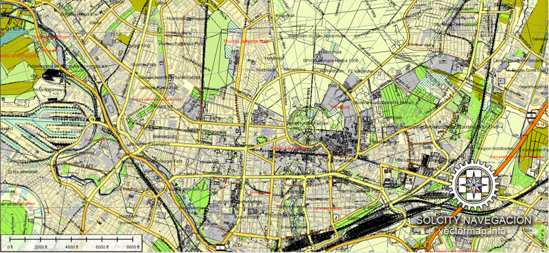
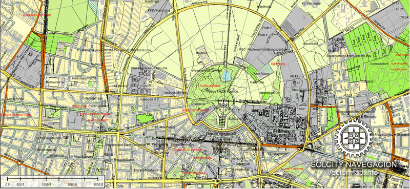
The city was planned with the palace tower (Schloss) at the center and 32 streets radiating out from it like the spokes of a wheel, or the ribs of a folding fan, so that one nickname for Karlsruhe in German is the “fan city” (Fächerstadt). Almost all of these streets survive to this day. Because of this city layout, in metric geometry, Karlsruhe metric refers to a measure of distance that assumes travel is only possible along radial streets and along circular avenues around the centre.
The city centre is the oldest part of town and lies south of the palace in the quadrant defined by nine of the radial streets. The central part of the palace runs east-west, with two wings, each at a 45° angle, directed southeast and southwest (i.e., parallel with the streets marking the boundaries of the quadrant defining the city center).
The market square lies on the street running south from the palace to Ettlingen. The market square has the town hall (Rathaus) to the west, the main Lutheran church (Evangelische Stadtkirche) to the east, and the tomb of Margrave Charles III William in a pyramid in the buildings, resulting in Karlsruhe being one of only three large cities in Germany where buildings are laid out in the neoclassical style.
The area north of the palace is a park and forest. Originally the area to the east of the palace consisted of gardens and forests, some of which remain, but the Karlsruhe Institute of Technology (founded in 1825), Wildparkstadion football stadium, and residential areas have been built there. The area west of the palace is now mostly residential.
You can edit all map data using different vector graphics editors like Adobe Illustrator, Freehand or CorelDraw, cropping, changing colors, fonts or borders, also adding your company logo or necessary objects. And also is a fully scalable map, no matter what size you need.
This vector map of Karlsruhe is available in different vector formats (the same price): .AI, .CDR .DWG, .DXF, .EPS, .PDF.
Royalty Free license. You don`t pay extra: per volume sold; for each use; for period of use.
Karlsruhe map with big “zoom” without quality degradation. The difference between raster and vector is that vector can be adjusted to any size you need with NO quality loss. Perfect for large-size printing (walls & billboards).
Probably, you need more objects to be added? Just tell us, we don`t charge for this work.
Karlsruhe map (Germany, Europe) in vector. Cities and counties near
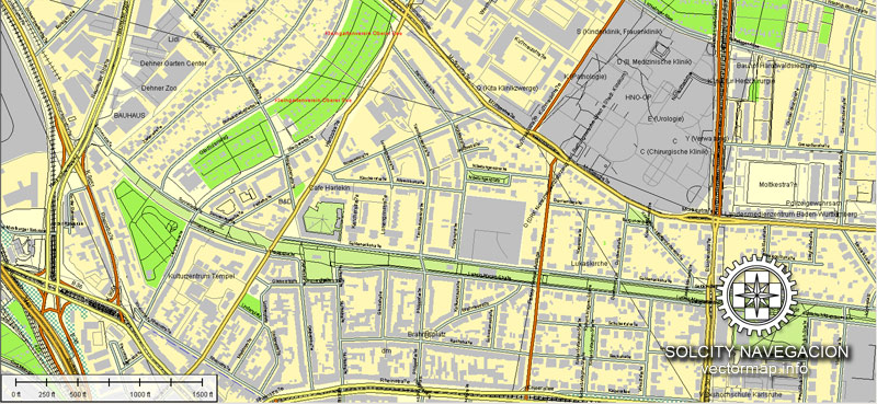
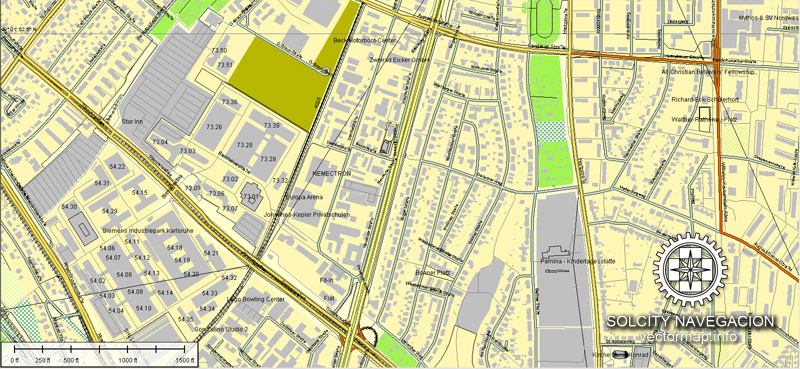
Our vector map of Karlsruhe includes maps of the nearest areas (see the preview):
Hagsfeld, Oststadt, Neureut, Knielingen, Daxlanden, Durlach and others.
Karlsruhe vector map for Adobe Illustrator. Purchasing and downloading.
We accept PayPal and Credit Card payment. After the payment you will be redirected to the download page.
The biggest base of Vector Maps. Maps containing streets with names, buildings, railways, airports or other objects needed.
[DE] Karlsruhe Vektorkarte. Deutschland, Europa
Archivgröße: 119 Mb, Reißverschluss .AI
DPI: 300
Diese Vektorkarten von Karlsruhe ist erstellt mit 2015 Daten.
Lizenz: Royalty Free
Karlsruhe (Deutschland) Vektorkarten in Adobe Illustrator-Format (.AI) verfügt (überprüfen Sie die Vorschaubilder):
Autobahnen mit Namen,
Hauptstraßen mit Namen,
Hauptverkehrsstraßen,
Damm,
Nationalpark Borders,
Nebenstraßen,
Große und kleine Flüsse, kleine Bäche auch,
See, Teichen und anderen Gewässern,
Landmark-Füllung,
Häuser,
Eisenbahn
Erholungszonen,
Parks.
Wir bieten Ihnen detaillierte Karten von Karlsruhe (Deutschland) in AI. Als Vektorkarten, sind sie vollständig bearbeitbare und skalierbare. Egal, welche groß ist der Druck-Größe Sie benötigen (Bürowandbild o bigboard). Diese Vektorkarten von Karlsruhe sind völlig kundengerecht, können Sie aktivieren oder deaktivieren Sie die Ebene, die Sie benötigen, auch komplette Karte mit Objekten benötigt wird, wie Sie Ihr Firmenlogo zum Beispiel.
Bitte auch andere Vektorkarten von Deutschland.
Sie können alle Kartendaten unter Verwendung verschiedener Vektor-Grafik-Editoren wie Adobe Illustrator, Freehand oder CorelDRAW, Beschneiden, wechselnden Farben, Schriftarten und Rahmen, auch das Hinzufügen Ihr Firmenlogo oder notwendigen Objekte zu bearbeiten. Und ist auch eine voll skalierbare Karte, egal, welche Größe Sie benötigen.
Diese Vektor-Karte von Karlsruhe ist in verschiedenen Vektor-Formate (zum gleichen Preis): .AI, .CDR DWG, DXF, EPS, PDF.
Lizenzfreie Lizenz. Sie don `t extra bezahlen: pro Volumen verkauft werden; für jede Anwendung; für die Zeit der Nutzung.
Karte Karlsruhe mit großen “zoom” ohne Qualitätsverlust. Der Unterschied zwischen Raster- und Vektor ist, dass Vektor kann auf jede Größe Sie ohne Qualitätsverlust müssen eingestellt werden. Perfekt für großformatige Druck (Wände & Plakatwände).
Wahrscheinlich müssen Sie mehrere Objekte hinzugefügt werden? Sagen Sie uns einfach, wir `t Gebühr für diese Arbeit.
Karlsruhe Karte (Deutschland, Europa) im Vektor. Städte und Landkreise in der Nähe
Unsere Vektor-Karte von Karlsruhe enthält Karten ihrer Umgebung (siehe Vorschau):
Hagsfeld, Oststadt, Neureut, Knielingen, Daxlanden, Durlach und andere.
Karlsruhe Vektorkarte für Adobe Illustrator. Kaufen und Herunterladen.
Wir akzeptieren PayPal und Kreditkarten-Zahlung. Nach der Bezahlung werden Sie zur Download-Seite umgeleitet werden.
Der größte Basis von Vektorkarten. Karten enthalten Straßen mit Namen, Gebäude, Eisenbahnen, Flughäfen oder andere Gegenstände benötigt.
Small guide: How to work with the vector map?
You can: Mass select objects by type and color – for example, the objects type “building” (they are usually dark gray) – and remove them from the map, if you do not need them in your print or design project. You can also easily change the thickness of lines (streets), just bulk selection the road by the line color.
The streets are separated by type, for example, type “residential road” are usually white with a gray stroke. Highway usually orange with a brown or dark gray stroke.
All objects are divided by types: different types of roads and streets, polygons of buildings, landfills, urban areas, parks and more other.
It is easy to change the font of inscriptions, all or each individually. Also, just can be make and any other manipulation of objects on the vector map in Adobe illustrator format.
Important: All the proportions on the map are true, that is, the relative sizes of the objects are true, because Map is based on an accurate GPS projection, and It transated into the (usual for all) the Mercator projection.
You can easily change the color, stroke and fill of any object on the map, zoom without loss of quality Image Verification.


 Author: Kirill Shrayber, Ph.D. FRGS

