Extended Description of the Vector Map
Printable PDF Vector Map of Hungary high detailed road map + admin areas 1, 2, + cities and water objects editable Layered Adobe PDF, scalable, editable text/curves format of names, 131 Mb ZIP.
Layered exact editable map: Map for publishing, design, printing, publications, arts, projects, presentations, for architects, designers, and builders, business, logistics. The most exact and detailed map. GPS correct Mercator Projection.
For printing any format.
Please note: in the preview, ALL LAYERS are enabled and visible. Of course, you can easily turn off the layers you don’t need and the map will become much simpler.
CDR, ESRI Shapes, and other formats – by request, the same price, please contact.
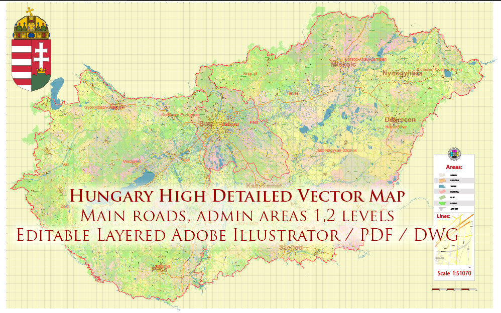
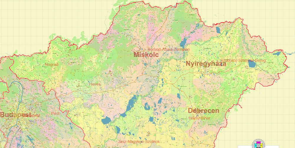
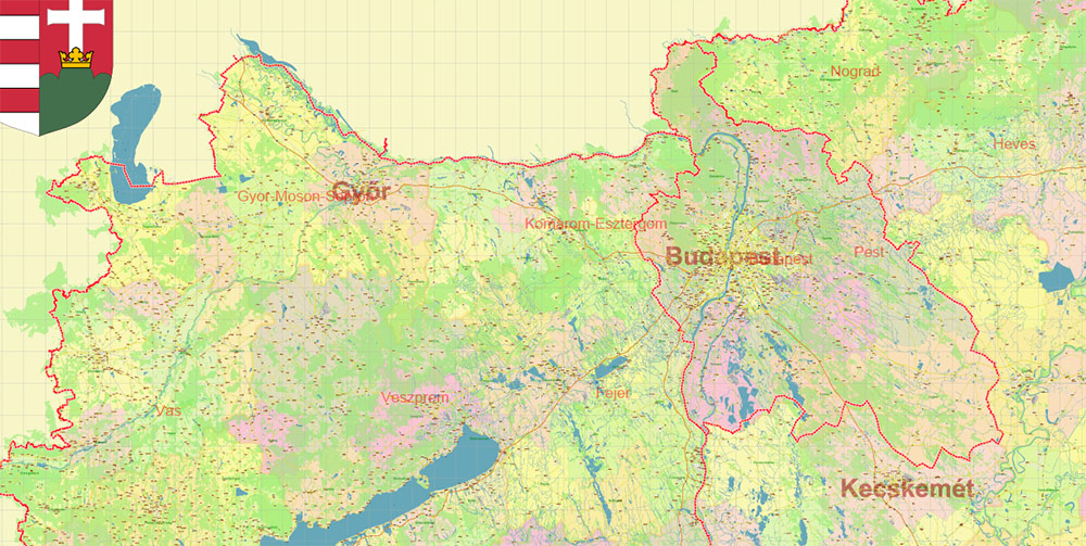
Hungary PDF Vector Map high detailed road map + admin areas 1, 2, + cities and water objects editable Layered Adobe PDF
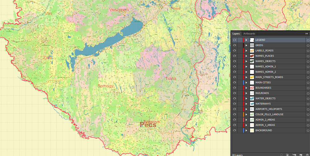
Separated layers:
- Legend
- Grids
- Road labels
- Names Main Cities
- Names Places
- Names objects (areas)
- Names Districts 2
- Names Provinces 1
- Urban areas / land use areas
- Main roads and streets
- Railroads
- Country boundaries
- Waterways
- Water areas
- Districts areas 2
- Provinces areas 1
- Background
1. HUNGARY: AO OVERVIEW
Landlocked Central European state positioned between Austria, Slovakia, Ukraine, Romania, Serbia, Croatia, and Slovenia. Core terrain dominated by the Carpathian Basin, split by the Danube corridor. Flat to rolling lowlands with two major operational regions: Transdanubia (west/southwest) and the Great Hungarian Plain (east). Highly centralized governance and infrastructure focused on Budapest. EU and Schengen member, high mobility across borders.
2. KEY TERRAIN & GEOGRAPHY
-
Danube River (Duna): Primary north–south artery bisecting the country; critical for transport, logistics, and urban concentration.
-
Tisza River: Dominant feature of the eastern operational zone; floodplain terrain, seasonal water hazards.
-
Carpathian Basin: Lowlands offering rapid vehicle movement, minimal natural choke points.
-
Lake Balaton: Largest lake in Central Europe; tourism hub; heavy summer population surge.
-
Transdanubian Hills: Rolling, forested, moderate obstruction to mechanized movement.
-
Northern Uplands (Mátra, Bükk): Mountainous sectors with limited passes, suitable for cover/concealment.
3. CLIMATE & SEASONALITY
Continental climate.
-
Summer: Hot, dry, excellent mobility; high tourism density.
-
Autumn: Fog, reduced visibility across river valleys.
-
Winter: Cold with snow/ice in northern highlands; Danube/Tisza crossings require caution.
-
Spring: Flooding risk on Tisza basin; impacts rural transport and agriculture zones.
4. DEMOGRAPHY & HUMAN TERRAIN
Population ~9.5M; highly centralized.
-
Budapest Metro: ~3M – political, economic, cultural center; key C2 node.
-
Ethnic composition: Predominantly Hungarian; minority Roma, German, Slovak, Romanian, Serbian, Croatian communities.
-
Religion: Mostly Catholic and Reformed Protestant.
-
Urban distribution: Major cities clustered along rivers and transport corridors; eastern plain more dispersed, agricultural.
Attitudes: Generally orderly, institution-respecting population; politically polarized environment but low civil instability risk.
5. KEY CITIES / URBAN AO
-
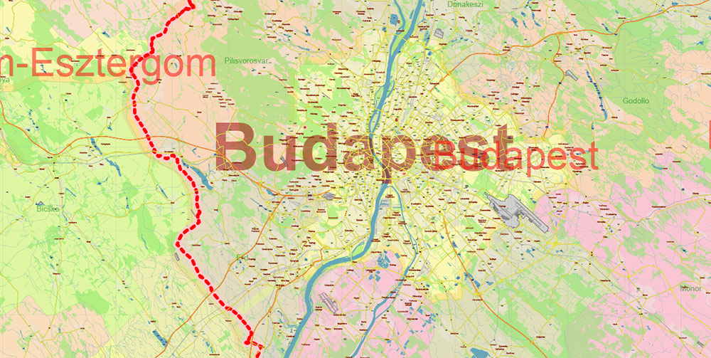
Budapest: Capital; dual-bank city split by Danube. Critical nodes: Parliament area, Castle District, Pest commercial core, major rail hubs (Keleti, Nyugati).
-
Debrecen: East-sector hub; industry, education, airport; access to Romanian frontier.
-
Szeged: South; Tisza river city; junction toward Serbia/Romania.
-
Miskolc: Northeast industrial cluster near highlands.
-
Győr: Northwest; manufacturing/logistics; close to Austrian/Slovak border.
-
Pécs: Southwest cultural/industrial zone near Croatian border.
6. KEY ROADS / LINES OF COMMUNICATION
Hungary has dense, high-quality motorway grid radiating from Budapest.
Motorways (M-series):
-
M1: Budapest → Győr → Vienna corridor (critical westbound LOC).
-
M3: Budapest → Miskolc → Nyíregyháza → Ukrainian border.
-
M5: Budapest → Kecskemét → Szeged → Serbia.
-
M6: Budapest → Dunaujváros → Pécs (southwest axis).
-
M7: Budapest → Lake Balaton → Croatia/Slovenia (tourist-heavy).
-
M0: Budapest orbital, key interchange for all national routes.
Secondary Routes:
7. ECONOMIC & INFRASTRUCTURE NOTES
-
Strong automotive and manufacturing sector in NW (Győr, Szombathely).
-
Agricultural east: grains, livestock, large open-field terrain.
-
Energy: mix of imports, nuclear (Paks plant), and moderate domestic production.
-
Telecommunications robust; high mobile penetration.
8. HAZARDS / THREATS
-
Flooding: Tisza and lower Danube zones.
-
Heatwaves: Summer operational stress.
-
Traffic bottlenecks: Budapest M0 orbital; Balaton region seasonal surges.
-
Political polarization: Mostly rhetorical; low kinetic risk.
9. LOGISTICS & SUSTAINMENT
-
Budapest Ferenc Liszt International Airport: primary air gateway; cargo-capable.
-
Rail freight corridors link to Austria, Slovakia, Romania, Serbia.
-
Extensive motorway network supports rapid redeployment.
-
Good medical infrastructure; highest concentration in Budapest and major regional centers.
10. COMMAND TAKEAWAYS
-
AO is high-mobility, mostly flat, with predictable infrastructure and few natural barriers.
-
Budapest is the decisive node for command, transport, and communications.
-
Danube/Tisza corridors dictate movement patterns and population centers.
-
Expect strong logistical performance via M-motorways and cross-border corridors.
-
Seasonal flooding and urban congestion are the main operational constraints.
Hungary PDF Vector Map high detailed road map + admin areas 1, 2, + cities and water objects editable Layered Adobe PDF
Hungary PDF Vector Map high detailed road map + admin areas 1, 2, + cities and water objects editable Layered Adobe PDF
Hungary PDF Vector Map high detailed road map + admin areas 1, 2, + cities and water objects editable Layered Adobe PDF
Hungary PDF Vector Map high detailed road map + admin areas 1, 2, + cities and water objects editable Layered Adobe PDF
Hungary PDF Vector Map high detailed road map + admin areas 1, 2, + cities and water objects editable Layered Adobe PDF


 Author: Kirill Shrayber, Ph.D. FRGS

