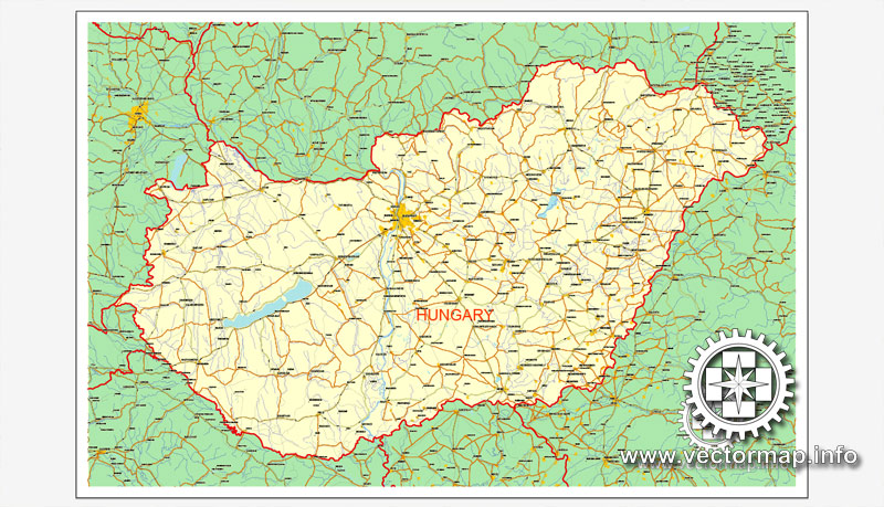
Hungary, printable vector Counrty map, full editable, CorelDRAW, full vector, scalable, editable, text format names, 2,1 mb ZIP
Only roads and boundaries, GPS correct Mercator Projection. Map for design, print, arts, projects, presentations, for architects, designers and builders.
PDF, DXF, DWG and other formats – on request, same price, please, contact
Magyarország, nyomtatható vektor Ország térkép, teljes szerkeszthető, CorelDRAW, a teljes vektor, méretezhető, szerkeszthető, szöveges formátumban utcanevek, 2,1 MB ZIP
Csak utak és határait, GPS helyes Mercator-vetület. Térkép a tervezés, nyomtatás, művészeti projektek, előadások, az építészek, tervezők és építők.
PDF, DXF, DWG, és más formátumok – kérésre, ugyanazon az áron, várjuk, contact
Hungary.
This vector map of Hungary is used as a basis for design, editing, and further printing.
This is the most detailed, exact map of Hungary for high-quality printing and polygraphy. You can always clarify the map development date by contacting us.
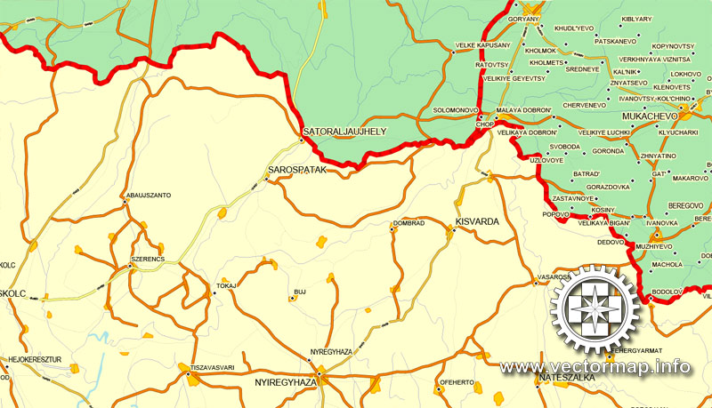
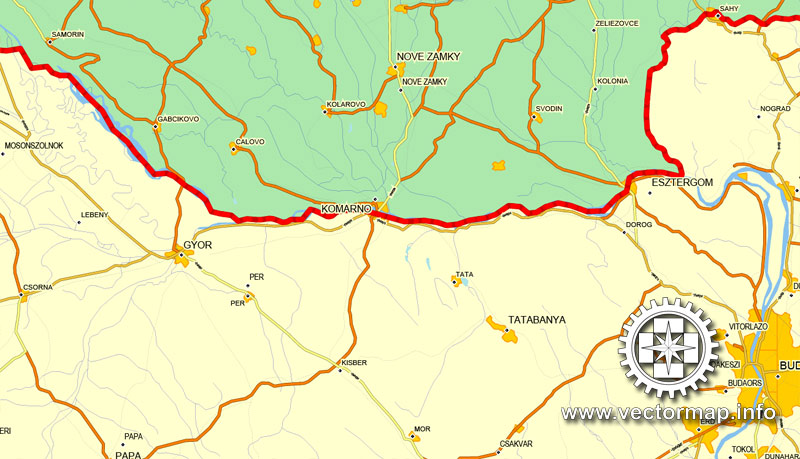
For your convenience, all objects on Hungary vector map are divided into layers. And the editing is very easy – colors, lines, etc.
You can easily add any objects needed (e.g. shops, salons, sale points, gas station or attraction) on any layer of Hungary vector map.
Hungary is a country in Central Europe. Spanning 93,030 square kilometres (35,920 sq mi) in the Carpathian Basin, it borders Slovakia to the north, Ukraine to the northeast, Austria to the northwest, Romania to the east, Serbia to the south, Croatia to the southwest, and Slovenia to the west. With about 10 million inhabitants, Hungary is a medium-sized member state of the European Union. The official language is Hungarian, which is the most widely spoken Uralic language in the world. Hungary’s capital and its largest city and metropolis is Budapest. Other major urban areas include Debrecen, Szeged, Miskolc, Pécs and Győr.
One of the advantages of Hungary vector maps of our production is the relevance of cartographic data, we constantly update all our products.
This vector map of Hungary is used by:
designers, layout designers, printers, advertisers and architects. Our product – vector maps – is designed for further editing and printing in large formats – from @Wall format (a few meters) to A-0 and A-1, A-2, A-3.
Hungary map in vector format is used for design, urban planning, presentations and media visualizations.
Advertising and presentation map of Hungary (usually the final designer marks the routes, and puts the client’s objects (shops, saloons, gas stations etc.)
The undoubted advantage is that people will NEVER throw out this advertising product – the map. In fact, as an advertising medium, a map is the most “long-playing” of the well-known polygraphic advertising media, with the longest lifespan, and the maximum number of interactions with the customer.
For travelers, maps are sold at the airports and gas stations around the world. Often the source is our vector maps.
Take a look, who purchases our vector maps of Hungary in “Our Clients and Friends” page – these are large and small companies, from super-brands like Volvo and Starbucks, to small design studios and printing houses.
It’s very easy to work with vector maps of Hungary, even for a not very experienced designer who can turn on and off the map layers, add new objects, change the colors of fill and lines according to customer requirements.
The undoubted advantage of Hungary vector maps in printing is an excellent and detailed visualization, when customer can expand a large paper map and instantly define his location, find a landmark, an object or address on map, unlike using the popular electronic formats of Google and Yandex maps for example.
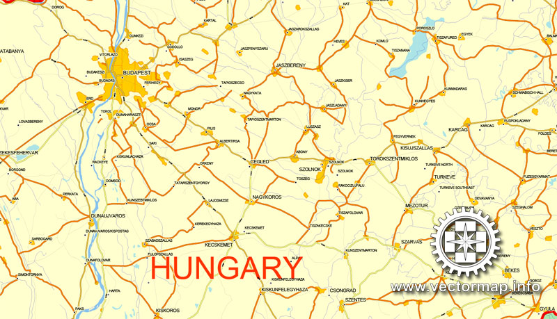
Printable vector maps of Hungary are much more convenient and efficient than any electronic maps on your smartphone, because ALL DETAILS are displayed in the entire space of Hungary map.
Useful tips on working with vector maps of cities and countries in Adobe Illustrator.
«V» – launches the Selection tool (cursor, black arrow), which makes active any vector line.
«А» – launches the Direct Selection tool (white cursor), allows you to select curve elements and drag them to the desired place.
«R» – activates the Rotate tool, which helps you rotating selected objects around the center point by 360 degrees.
«E» – gives you the opportunity to use the Eraser tool and erase unnecessary parts.
«X» – switches between Fill and Stroke in the Tools section. Try to get used to this hot key and
you will quickly understand that you can’t live and work without it.
Guides are not limited to vertical and horizontal in Adobe Illustrator. You can also create a diagonal guide for example. Moreover, you can turn any contours into guides. Select the outline and go to View > Guides > Make Guides (Create Guides), or simply press Cmd/Ctrl + 5. You can also turn the guides back into an editable object. Go to menu, View > Guides > Unlock Guides (Release Guides), select the guide you want to edit and select View > Guides > Release Guides (Reset Guides), or just press Cmd/Ctrl + Option / Alt + 5).
You will probably want to change the color scheme used on our Hungary vector map.
To quickly and effectively play with colors.
Of course, you can do it manually, all objects in our Hungary vector map are divided according to types and layers, and you can easily change the color gamma of vector objects in groups and layers.
But there is more effective way of working with the whole VECTOR MAP of Hungary and all layers:
The overview dialog «Edit colors»/«Repaint Graphic Object» (this dialog box name can change depending on the context):
If you have selected a part or a layer of Hungary vector map and open the dialog box by clicking the icon in the Control panel, on the Samples palette or the Color Catalog, or if you choose Edit > Edit Colors> Repaint Graphic Object, then the «Repaint Graphic Object» dialog box appears, and you get access to «Assign» and «Edit» tabs.
If a picture or a map fragment is not selected, and you open the dialog box by clicking the icon in the Control panel, on the Samples palette or in the Color Catalog, the «Edit Colors» dialog box appears and you can only access the «Edit» tab.
Regardless of the name at the top of the dialog box, the right-hand side always displays the color group of the current document, as well as two default color groups: Print Color and Grayscale. These color groups can be selected and used any time.
Create and edit color groups of Hungary vector map, and also assign colors using the «Edit Colors»/ а «Repaint Graphic Object» dialog box.
A. Creating and editing of a color group on the «Edit» tab
B. Assigning colors on the «Assign» tab
C. Select a group of colors from the «Color groups» list
The option «Repaint a graphic object» in the lower part of the dialog box allows you to preview the colors on a selected layer of Vector map, or a group of elements, and specify whether its colors will be redefined when the dialog box is closed.
The main areas of the dialog box are:
«Edit»
The «Edit» tab is designed to create a new or edit the existing color groups.
The harmony rules Menu and the Color Wheel are used to conduct experiments with color harmonies. The color wheel shows how colors are related in color harmony, and the color bars allow you to view and manipulate an individual color values. In addition, you can adjust the brightness, add and remove colors, save color groups and view colors on the selected Vector Map of Hungary or a separated layers.
«Assign»
The «Assign» tab is used to view and control on how the original colors are replaced with colors from the color group like your corporate colors in the Vector Map of Hungary.
The assign color ability is provided only if the entire map, layer or fragment is selected in the document. You can specify which of new colors replace the current colors, whether the spot colors should be preserved and how colors are replaced (for example, you can replace colors completely or changing the color tone while maintaining the brightness). The «Assign» tab allows you to redefine colors in the Vector Map of Hungary, or in separate layers and fragments using the current color group or reducing the number of colors in the current Vector Map.
Color groups
Is a list of all saved color groups for current document (the same groups appear in the «Samples» palette). You can edit and delete the existing color groups, as well as creating a new ones using the list of “Color Groups” in the dialog box. All changes appear in the «Samples» palette.
The highlighted color group shows, which color group is currently edited.
The territory of modern Hungary was for centuries inhabited by a succession of peoples, including Celts, Romans, Germanic tribes, Huns, West Slavs and the Avars. The foundations of the Hungarian state was established in the late ninth century AD by the Hungarian grand prince Árpád following the conquest of the Carpathian Basin. His great-grandson Stephen I ascended the throne in 1000, converting his realm to a Christian kingdom. By the 12th century, Hungary became a regional power, reaching its cultural and political height in the 15th century. Following the Battle of Mohács in 1526, Hungary was partially occupied by the Ottoman Empire (1541–1699). It came under Habsburg rule at the turn of the 18th century, and later joined Austria to form the Austro–Hungarian Empire, a major European power.
Any color group can be selected and edited, or used to redefine the colors in the selected vector map of Hungary, its fragments or elements.
Saving a color group adds this group to the specified list.
Opening the «Edit Colors»/«Repaint Graphic Object» dialog box.
Open the «Edit Colors»/«Repaint Graphic Object» dialog box using one of the following methods:
«Edit»> «Edit Colors»> «Repaint Graphic object» or «Repaint With Style».
Use these commands if you need to edit the colors in the selected vector map of Hungary.
«Repaint Graphic object» button on the «Control» panel.
Use this button if you need to adjust colors of Hungary vector map using the а «Repaint graphic object» dialog box.
The specified button is available if the selected vector map or its fragment contains two or more colors.
Note. This color editing method is convenient for global color adjustment in a vector map, if global colors were not used when creating a Map of Hungary.
The «Edit colors» button or «Edit or apply colors» on the «Color Catalog» palette
Click this button if you need to edit colors on the «Color Catalog» palette or edit and then apply them to the selected Vector Map of Hungary or its fragment.
The «Edit color group» button or «Edit or apply color group» on the «Samples» palette.
Click this button if you need to edit the colors in the specific color group or edit and apply them to the selected Vector Map of Hungary or a group of its elements, for example, the whole layer “Streets and lines”. You can also double-click the color group in the Samples panel to open the dialog box.
If the map file is too large and your computer freezes or even can’t open it quickly:
1. Try to reduce the color resolution of the video card (display) to 256 colors while working with a large map.
2. Using Windows Task Manager, select all the application you don’t need, while working with map, just turn them off.
3. Launch Adobe Illustrator. (DO NOT OPEN the vector map file)
4. Start the Windows Task Manager using administrator rights > Find the “Illustrator” process > set the «real time» priority,
5. Open the file. When you see the LEGACY FONT popup window – click “OK” (do not update). You can restore the TEXT later.
6. Can also be useful: When file is opened – Edit > Settings > Basic Settings > disable smoothing. /// It looks scary, but works quickly)))
We recommend saving the file in Adobe Illustrator 10 version. It’s much more stable when working with VERY BIG size files.
The Austro-Hungarian Empire collapsed after World War I, and the subsequent Treaty of Trianon established Hungary’s current borders, resulting in the loss of 71% of its territory, 58% of its population, and 32% of ethnic Hungarians. Following the tumultuous interwar period, Hungary joined the Axis Powers in World War II, suffering significant damage and casualties. Hungary became a satellite state of the Soviet Union, which contributed to the establishment of a socialist republic spanning four decades (1949–1989).The country gained widespread international attention as a result of its 1956 revolution and the seminal opening of its previously-restricted border with Austria in 1989, which accelerated the collapse of the Eastern Bloc. On 23 October 1989, Hungary became a democratic parliamentary republic.
In the 21st century, Hungary is a middle power and has the world’s 57th largest economy by nominal GDP, as well as the 58th largest by PPP, out of 191 countries measured by IMF. As a substantial actor in several industrial and technological sectors, it is the world’s 35th largest exporter and 34th largest importer of goods. Hungary is an OECD high-income economy with a very high standard of living. It keeps up a social security and universal health care system, and a tuition-free university education. Hungary performs well in international rankings: it is 20th in quality of life, 24th in the Good Country Index, 28th in inequality-adjusted human development, 32nd in the Social Progress Index, 33rd in the Global Innovation Index and ranks as the 15th safest country in the world.
Hungary joined the European Union in 2004 and has been part of the Schengen Area since 2007. Hungary is a member of the United Nations, NATO, WTO, World Bank, the AIIB, the Council of Europe, the Visegrád Group and more. Well known for its rich cultural history, Hungary has contributed significantly to arts, music, literature, sports and science and technology. Hungary is the 11th most popular country as a tourist destination in Europe, attracting 14.3 million international tourists in 2015. It is home to the largest thermal water cave system and the second largest thermal lake in the world, the largest lake in Central Europe and the largest natural grasslands in Europe.
Geography
Hungary’s geography has traditionally been defined by its two main waterways, the Danube and Tisza rivers. The common tripartite division of the country into three sections—Dunántúl (“beyond the Danube”, Transdanubia), Tiszántúl (“beyond the Tisza”), and Duna-Tisza köze (“between the Danube and Tisza”)—is a reflection of this. The Danube flows north-south right through the center of contemporary Hungary, and the entire country lies within its drainage basin.
Transdanubia, which stretches westward from the center of the country toward Austria, is a primarily hilly region with a terrain varied by low mountains. These include the very eastern stretch of the Alps, Alpokalja, in the west of the country, the Transdanubian Mountains in the central region of Transdanubia, and the Mecsek Mountains and Villány Mountains in the south. The highest point of the area is the Írott-kő in the Alps, at 882 metres (2,894 ft). The Little Hungarian Plain (Kisalföld) is found in northern Transdanubia. Lake Balaton and Lake Hévíz, the largest lake in Central Europe and the largest thermal lake in the world, respectively, are in Transdanubia as well.
The Duna-Tisza köze and Tiszántúl are characterized mainly by the Great Hungarian Plain (Alföld), which stretches across most of the eastern and southeastern areas of the country. To the north of the Plain are the foothills of the Carpathians in a wide band near the Slovakian border. The Kékes at 1,014 m or 3,327 ft is the tallest mountain in Hungary and is found here.
Phytogeographically, Hungary belongs to the Central European province of the Circumboreal Region within the Boreal Kingdom. According to the WWF, the territory of Hungary belongs to the ecoregion of Pannonian mixed forests.
Hungary has 10 national parks, 145 minor nature reserves, and 35 landscape protection areas.
Hungary traces its history back to the Magyars, an alliance of semi-nomadic tribes from southern Russia and the Black Sea coast that arrived in the region in the ninth century.
After centuries as a powerful medieval kingdom, Hungary was part of the Ottoman and then Habsburg empires from the 16th century onwards, emerging as an independent country again after World War I.
A landlocked country, Hungary is home to Lake Balaton, the largest in central Europe, and to a large number of spa towns and hot springs.
It has especially rich traditions in folk and classical music and has been the birthplace of many outstanding performers and composers, including Franz Liszt, Bela Bartok and Zoltan Kodaly.
http://www.bbc.com/news/world-europe-17380792

 Author: Kirill Shrayber, Ph.D. FRGS

