Extended Description of the Vector Map
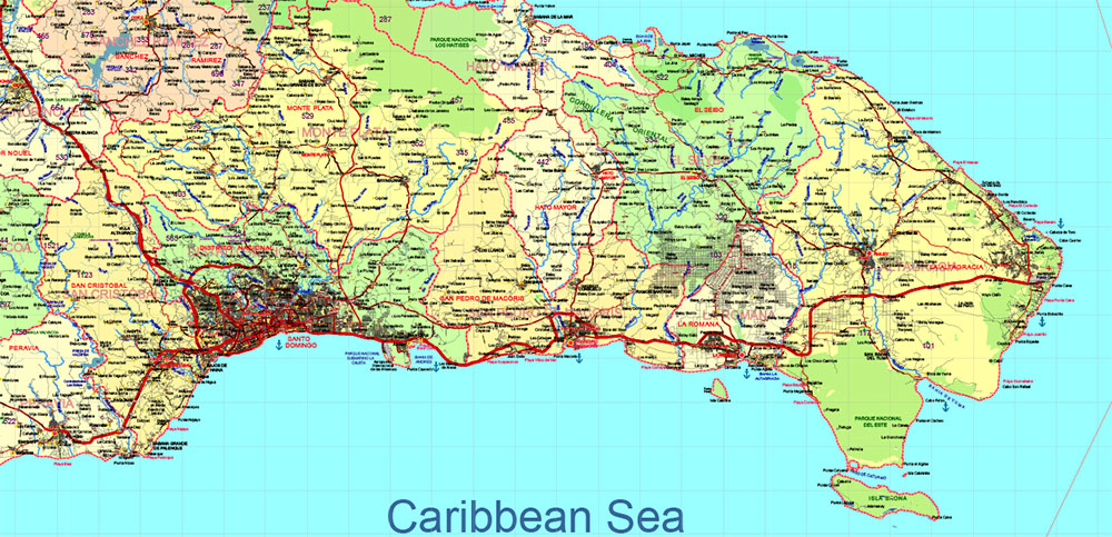
Printable Vector Map of Dominicana and Haiti high detailed road map + country areas + provinces areas + main cities and towns and water objects editable Layered Adobe Illustrator, scalable, editable text format of all names, 62 Mb ZIP.
Layered exact editable map: Map for publishing, design, printing, publications, arts, projects, presentations, for architects, designers, and builders, business, logistics. The most exact and detailed map. GPS correct Mercator Projection.
For printing any size. For printing in any size – from A3 to Wall extra large format Extra Detailed.

Dominicana and Haiti HD Vector Map high detailed roads editable layered in Adobe Illustrator
Separated layers:
- Legend
- Grids
- Road labels
- Ponts main Cities
- Ponts towns
- Points all cities, towns and villages
- Points of the Airports
- Points of the Seaport
- Elevation points + elev. data
- Elevation points + data vers. 2
- Names Cities and Towns (with halo)
- Points Geo (main cities and towns)
- Names provinces
- Names objects (parks, hospitals)
- Provinces areas
- Provinces boundaries
- Main boundaries
- Names Countries
- Names water objects
- Names sea objects
- Names natural reserve areas
- Names playas
- Names main roads and streets
- Urban areas
- Main roads
- Simplified Main Roads
- Secondary roads
- Railroads
- Country boundaries
- Waterways
- Waterways bold
- Water areas
- Country areas
- Sea / Ocean
The island of Hispaniola , located in the Caribbean Sea, is shared by two countries: Dominican Republic (officially known as República Dominicana) and Haiti . These two nations occupy distinct geographical regions with unique landscapes, climates, ecosystems, and human influences. Below is a detailed geographical description of both countries:
1. Dominican Republic
Location and General Geography
- The Dominican Republic occupies the eastern two-thirds of Hispaniola.
- It is bordered by the Atlantic Ocean to the north, the Caribbean Sea to the south, and Haiti to the west.
- Total land area: Approximately 48,670 square kilometers (18,792 sq mi) .
Topography
The Dominican Republic features a diverse topography:
- Mountain Ranges :
- The Cordillera Central runs through the center of the country and contains the highest peak in the Caribbean, Pico Duarte , at 3,098 meters (10,164 feet) .
- Other significant ranges include the Sierra de Neiba and the Sierra de Bahoruco in the southwest.
- Valleys : Fertile valleys such as the Cibao Valley in the north are important for agriculture.
- Coastal Plains : Low-lying coastal plains are found along the northern and southern coasts, including the Samaná Peninsula in the northeast.
- Lakes and Rivers :
- Lake Enriquillo , the largest lake in the Caribbean, lies in the southwestern part of the country. It is a saltwater lake and sits below sea level.
- Major rivers include the Yaque del Norte (the longest river in the country) and the Yaque del Sur .
Climate
- The climate varies significantly due to elevation and proximity to water bodies:
- Tropical Climate : Coastal areas experience warm temperatures year-round, with average highs of 28–32°C (82–90°F) .
- Temperate Climate : Higher elevations in the mountains have cooler temperatures, especially in winter.
- Rainfall : The country has a wet season from May to November, coinciding with the Atlantic hurricane season. Rainfall is heaviest in the northern and eastern regions.
Natural Resources
- Rich in natural resources, including fertile soil, minerals (gold, silver, nickel), and forests.
- Biodiversity includes tropical rainforests, mangroves, and coral reefs.
Environmental Challenges
- Deforestation due to agriculture and logging.
- Soil erosion and water pollution from mining activities.
- Vulnerability to hurricanes and tropical storms.
2. Haiti
Location and General Geography
- Haiti occupies the western one-third of Hispaniola.
- It is bordered by the Caribbean Sea to the south, the Gulf of Gonâve to the west, and the Dominican Republic to the east.
- Total land area: Approximately 27,750 square kilometers (10,714 sq mi) .
Topography
Haiti’s terrain is rugged and mountainous:
- Mountain Ranges :
- The Massif du Nord extends into Haiti from the Dominican Republic.
- The Chaîne de la Selle in the south contains Pic la Selle , Haiti’s highest peak at 2,680 meters (8,793 feet) .
- Plateaus : Central and northern regions feature elevated plateaus.
- Valleys : Limited fertile valleys, such as the Artibonite Valley , are crucial for agriculture.
- Coastal Areas : Narrow coastal plains exist along the northern and southern shores.
- Islands : Haiti includes several offshore islands, such as Île de la Gonâve , Île à Vache , and Tortuga .
Climate
- Haiti has a tropical climate with some regional variations:
- Lowlands : Hot and humid, with temperatures averaging 25–35°C (77–95°F) .
- Highlands : Cooler temperatures, especially in mountainous areas.
- Rainfall : A rainy season occurs from April to June and a secondary wet period from August to October. Northern and eastern regions receive more rainfall than the drier southern areas.
Natural Resources
- Haiti has limited natural resources compared to the Dominican Republic:
- Small deposits of bauxite, copper, and gold.
- Agricultural products like coffee, mangoes, and sugarcane are grown in fertile valleys.
Environmental Challenges
- Severe deforestation, with less than 2% of the original forest cover remaining. This has led to soil erosion, loss of biodiversity, and increased vulnerability to flooding.
- Water scarcity and contamination due to poor infrastructure and overuse.
- Earthquake-prone region; the capital, Port-au-Prince, was devastated by a major earthquake in 2010.
Comparative Geographical Features
Conclusion
The Dominican Republic and Haiti share the same island but exhibit stark contrasts in their geography, resource distribution, and environmental health. While the Dominican Republic benefits from greater forest cover, fertile valleys, and mineral wealth, Haiti faces severe environmental degradation, deforestation, and limited natural resources. These differences have shaped the economic and social development of each nation, contributing to their distinct identities despite their shared history and geography.

Dominicana and Haiti HD Vector Map high detailed roads editable layered in Adobe Illustrator
Dominicana and Haiti HD Vector Map high detailed roads editable layered in Adobe Illustrator

Dominicana and Haiti HD Vector Map high detailed roads editable layered in Adobe Illustrator

Dominicana and Haiti HD Vector Map high detailed roads editable layered in Adobe Illustrator

Dominicana and Haiti HD Vector Map high detailed roads editable layered in Adobe Illustrator

Dominicana and Haiti HD Vector Map high detailed roads editable layered in Adobe Illustrator

Dominicana and Haiti HD Vector Map high detailed roads editable layered in Adobe Illustrator

Dominicana and Haiti (Hispaniola) HD Vector Map high detailed roads editable layered in Adobe Illustrator

Dominicana and Haiti HD Vector Map high detailed roads editable layered in Adobe Illustrator

 Author: Kirill Shrayber, Ph.D. FRGS


