Extended Description of the Vector Map
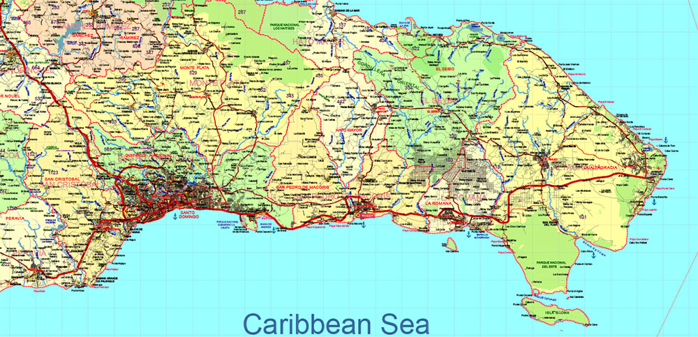
Printable PDF Vector Map of Dominicana and Haiti high detailed road map + country areas + provinces areas + main cities and towns and water objects editable Layered Adobe PDF, scalable, editable text format of all names, 161 Mb ZIP.
Layered exact editable map: Map for publishing, design, printing, publications, arts, projects, presentations, for architects, designers, and builders, business, logistics. The most exact and detailed map. GPS correct Mercator Projection.
For printing any size. For printing in any size – from A3 to Wall extra large formap Extra Detailed.

Dominicana and Haiti (Hispaniola) HD PDF Vector Map high detailed roads editable layered in Adobe PDF
Separated layers:
- Legend
- Grids
- Road labels
- Ponts main Cities
- Ponts towns
- Points all cities, towns and villages
- Points of the Airports
- Points of the Seaport
- Elevation points + elev. data
- Elevation points + data vers. 2
- Names Cities and Towns (with halo)
- Points Geo (main cities and towns)
- Names provinces
- Names objects (parks, hospitals)
- Provinces areas
- Provinces boundaries
- Main boundaries
- Names Countries
- Names water objects
- Names sea objects
- Names natural reserve areas
- Names playas
- Names main roads and streets
- Urban areas
- Main roads
- Simplified Main Roads
- Secondary roads
- Railroads
- Country boundaries
- Waterways
- Waterways bold
- Water areas
- Country areas
- Sea / Ocean
The Dominican Republic and Haiti share the island of Hispaniola in the Caribbean, but they have distinct histories, cultures, and infrastructures. Below is an overview of the principal cities and roads in each country:
Dominican Republic
Principal Cities
- Santo Domingo
- The capital and largest city of the Dominican Republic.
- It is the cultural, political, and economic center of the country.
- Key landmarks include the Colonial Zone (a UNESCO World Heritage Site), the Alcázar de Colón, and the Cathedral of Santa María la Menor.
- Santiago de los Caballeros
- The second-largest city and a major industrial and commercial hub.
- Known for its tobacco and cigar production, as well as its vibrant culture.
- Puerto Plata
- A major tourist destination on the northern coast, known for its beaches and historical sites like the San Felipe Fortress.
- La Romana
- Famous for its luxury resorts, including Casa de Campo, and its sugar industry.
- San Pedro de Macorís
- An important port city and a center for sugar production and baseball talent.
- Barahona
- Located in the southwestern region, known for its natural beauty, including beaches and mountains.
- Higüey
- A religious and cultural center, home to the Basilica of Our Lady of Altagracia, one of the most important pilgrimage sites in the country.
Principal Roads
- Autopista Duarte (DR-1)
- The main highway connecting Santo Domingo to Santiago and other northern cities.
- It is the longest and most important road in the country.
- Autopista del Este (DR-3)
- Connects Santo Domingo to the eastern tourist destinations, including La Romana, Punta Cana, and Bávaro.
- Carretera Sánchez (DR-2)
- Links Santo Domingo to the western regions, including San Cristóbal and Barahona.
- Autopista del Coral (DR-4)
- Runs along the southeastern coast, connecting Santo Domingo to La Romana and other coastal areas.
- Carretera Mella (DR-8)
- Connects Santo Domingo to Higüey and the eastern provinces.
Haiti
Principal Cities
- Port-au-Prince
- The capital and largest city of Haiti.
- It is the country’s political, economic, and cultural center.
- Notable landmarks include the Iron Market (Marché en Fer) and the National Palace (destroyed in the 2010 earthquake).
- Cap-Haïtien
- The second-largest city and a key historical site, often referred to as the “Paris of the Antilles.”
- Known for its colonial architecture and proximity to the Citadelle Laferrière and Sans-Souci Palace (UNESCO World Heritage Sites).
- Gonaïves
- Known as the “City of Independence” because it was the site where Haiti declared its independence in 1804.
- A major port city on the Gulf of Gonâve.
- Les Cayes
- A significant port city in the southern part of Haiti.
- Known for its agricultural production and as a gateway to the southwestern peninsula.
- Jacmel
- A coastal city famous for its arts scene, colorful architecture, and annual Carnival celebrations.
- Saint-Marc
- A port city on the central western coast, serving as a hub for trade and transportation.
- Jérémie
- Located on the southern peninsula, known for its mango production and scenic beauty.
Principal Roads
- Route Nationale #1 (RN-1)
- The main highway connecting Port-au-Prince to Cap-Haïtien via Saint-Marc and Gonaïves.
- It is one of the most important roads in the country.
- Route Nationale #2 (RN-2)
- Links Port-au-Prince to Jacmel and other southern cities.
- Provides access to the southeastern region of Haiti.
- Route Nationale #3 (RN-3)
- Connects Port-au-Prince to Les Cayes and other southwestern cities.
- Vital for transportation in the southern peninsula.
- Route Nationale #4 (RN-4)
- Runs through the Artibonite Valley, connecting Gonaïves to Hinche and other central regions.
- Route de l’Amitié (Friendship Road)
- A newer road built with international assistance, improving connectivity between Port-au-Prince and key areas.
Key Differences Between the Two Countries
- Infrastructure Quality :
- The Dominican Republic generally has better-maintained roads and highways compared to Haiti, which faces challenges due to limited resources and natural disasters.
- Urbanization :
- The Dominican Republic has more developed urban centers with modern amenities, while Haiti’s cities often face overcrowding and infrastructure deficits.
- Tourism Focus :
- The Dominican Republic is a major tourist destination, with roads designed to connect resorts and attractions. Haiti’s tourism infrastructure is less developed, though it has rich historical and cultural sites.
Shared Geography
- Both countries share the island of Hispaniola, but their borders are marked by the Cordillera Central mountain range and the Artibonite River.
- Cross-border roads exist, but travel between the two countries can be challenging due to differences in infrastructure and border regulations.

Dominicana and Haiti (Hispaniola) HD PDF Vector Map high detailed roads editable layered in Adobe PDF
Dominicana and Haiti (Hispaniola) HD PDF Vector Map high detailed roads editable layered in Adobe PDF

Dominicana and Haiti (Hispaniola) HD PDF Vector Map high detailed roads editable layered in Adobe PDF

Dominicana and Haiti (Hispaniola) HD PDF Vector Map high detailed roads editable layered in Adobe PDF

Dominicana and Haiti (Hispaniola) HD PDF Vector Map high detailed roads editable layered in Adobe PDF

Dominicana and Haiti (Hispaniola) HD PDF Vector Map high detailed roads editable layered in Adobe PDF

Dominicana and Haiti (Hispaniola) HD PDF Vector Map high detailed roads editable layered in Adobe PDF

Dominicana and Haiti (Hispaniola) HD PDF Vector Map high detailed roads editable layered in Adobe PDF

Dominicana and Haiti (Hispaniola) HD PDF Vector Map high detailed roads editable layered in Adobe PDF

 Author: Kirill Shrayber, Ph.D. FRGS


