Extended Description of the Vector Map
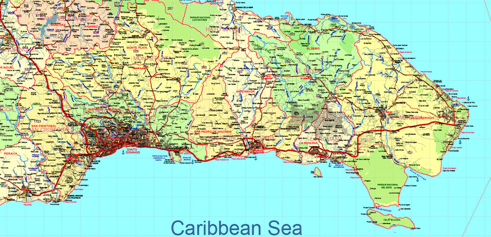
Printable DWG Vector Map of Dominicana and Haiti high detailed road map + country areas + provinces areas + main cities and towns and water objects editable Layered AutoCAD DWG, scalable, editable text format of all names, 211 Mb ZIP.
Layered exact editable map: Map for publishing, design, printing, publications, arts, projects, presentations, for architects, designers, and builders, business, logistics. The most exact and detailed map. GPS correct Mercator Projection.
For printing any size. For printing in any size – from A3 to Wall extra large formap Extra Detailed.

Dominicana and Haiti (Hispaniola) HD DWG Vector Map high detailed roads editable layered in AutoCAD DWG
Separated layers:
- Legend
- Grids
- Road labels
- Ponts main Cities
- Ponts towns
- Points all cities, towns and villages
- Points of the Airports
- Points of the Seaport
- Elevation points + elev. data
- Elevation points + data vers. 2
- Names Cities and Towns (with halo)
- Points Geo (main cities and towns)
- Names provinces
- Names objects (parks, hospitals)
- Provinces areas
- Provinces boundaries
- Main boundaries
- Names Countries
- Names water objects
- Names sea objects
- Names natural reserve areas
- Names playas
- Names main roads and streets
- Urban areas
- Main roads
- Simplified Main Roads
- Secondary roads
- Railroads
- Country boundaries
- Waterways
- Waterways bold
- Water areas
- Country areas
- Sea / Ocean
The Dominican Republic and Haiti share the island of Hispaniola, but their approaches to managing water resources and developing infrastructure differ significantly. Below is a detailed breakdown of the principal water resources (rivers and lakes) and seaport infrastructure in both countries:
Dominican Republic
Principal Water Resources
- Rivers :
- Yaque del Norte : The longest river in the Dominican Republic, flowing approximately 296 km. It originates in the Cordillera Central and empties into Monte Cristi Bay. It is vital for irrigation and hydroelectric power.
- Yaque del Sur : A major river that flows about 185 km through the southwestern part of the country, emptying into the Caribbean Sea. It supports agriculture and hydroelectric projects.
- Ozama River : One of the most important rivers in the eastern part of the country, flowing through Santo Domingo and emptying into the Caribbean Sea. It is crucial for urban water supply and transportation.
- Artibonito River : Though primarily associated with Haiti, the upper portion of this river originates in the Dominican Republic before crossing into Haiti.
- Lakes :
- Lake Enriquillo : The largest lake in the Caribbean, located in the southwestern region. It is a hypersaline lake and an important ecological site, home to unique species like the American crocodile.
- Lake Cabral : A smaller freshwater lake in the southwestern region, used for irrigation and fishing.
Seaport Infrastructure
The Dominican Republic has several key ports that facilitate trade and tourism:
- Port of Santo Domingo : The largest and busiest port in the country, located on the Ozama River. It handles a significant portion of the country’s imports and exports.
- Port of Haina : Located near Santo Domingo, it is one of the main industrial ports, handling containerized cargo and bulk goods.
- Port of Puerto Plata : Situated on the northern coast, it is a hub for tourism and commerce, serving cruise ships and cargo vessels.
- Port of Rio Haina : A deep-water port designed for large vessels, focusing on containerized and bulk cargo.
- Port of La Romana : Important for industrial exports, particularly from the sugar and manufacturing sectors.
- Port of Barahona : Located on the southern coast, it serves agricultural and mining industries.
Haiti
Principal Water Resources
- Rivers :
- Artibonito River : The longest river in Haiti, flowing approximately 321 km. It originates in the Dominican Republic and is crucial for irrigation and hydroelectric power generation in Haiti.
- Grande Rivière du Nord : A significant river in northern Haiti, supporting agriculture and small-scale hydroelectric projects.
- Rivière de l’Est : Flows through the eastern part of Haiti, providing water for irrigation and local communities.
- Lakes :
- Étang Saumâtre (Lake Azuéi) : The largest lake in Haiti, located near the border with the Dominican Republic. It is a brackish water lake and an important ecological site.
- Lake Miragoâne : A freshwater lake in the southern part of Haiti, used for fishing and irrigation.
Seaport Infrastructure
Haiti’s port infrastructure is less developed compared to the Dominican Republic, but several key ports are critical for its economy:
- Port-au-Prince : The primary port of Haiti, located in the capital city. It handles most of the country’s imports and exports, including food, fuel, and manufactured goods.
- Port of Cap-Haïtien : Located on the northern coast, it serves as a secondary port for trade and is also important for tourism.
- Port of Jacmel : A smaller port on the southern coast, used for regional trade and tourism.
- Port of Les Cayes : Located in the southwestern region, it supports agricultural exports and regional trade.
- Port of Gonaïves : An important port for the Artibonito region, serving agricultural and industrial needs.
Key Observations
- Water Resources :
- Both countries rely heavily on shared rivers like the Artibonito, which underscores the importance of cross-border cooperation in water management.
- The Dominican Republic has more developed infrastructure for harnessing water resources, such as dams and irrigation systems, while Haiti faces challenges due to political instability and lack of investment.
- Seaport Infrastructure :
- The Dominican Republic has modernized and expanded its ports to support its growing economy and tourism industry.
- Haiti’s ports are less developed and face challenges such as limited capacity, outdated facilities, and vulnerability to natural disasters.
- Environmental Concerns :
- Both countries face environmental challenges related to deforestation, soil erosion, and pollution of water bodies, which threaten their shared water resources.
Conclusion
The Dominican Republic and Haiti have distinct water resources and seaport infrastructures shaped by their economic priorities, governance, and historical development. While the Dominican Republic has invested in modernizing its water management and port facilities, Haiti struggles with underdeveloped infrastructure and resource management challenges. Collaborative efforts between the two nations could help address shared water resource issues and improve regional trade and sustainability.

Dominicana and Haiti (Hispaniola) HD DWG Vector Map high detailed roads editable layered in AutoCAD DWG
Dominicana and Haiti (Hispaniola) HD DWG Vector Map high detailed roads editable layered in AutoCAD DWG

Dominicana and Haiti (Hispaniola) HD DWG Vector Map high detailed roads editable layered in AutoCAD DWG

Dominicana and Haiti (Hispaniola) HD DWG Vector Map high detailed roads editable layered in AutoCAD DWG

Dominicana and Haiti (Hispaniola) HD DWG Vector Map high detailed roads editable layered in AutoCAD DWG

Dominicana and Haiti (Hispaniola) HD DWG Vector Map high detailed roads editable layered in AutoCAD DWG

Dominicana and Haiti (Hispaniola) HD DWG Vector Map high detailed roads editable layered in AutoCAD DWG

Dominicana and Haiti (Hispaniola) HD DWG Vector Map high detailed roads editable layered in AutoCAD DWG

Dominicana and Haiti (Hispaniola) HD DWG Vector Map high detailed roads editable layered in AutoCAD DWG

 Author: Kirill Shrayber, Ph.D. FRGS


