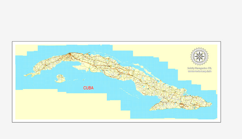
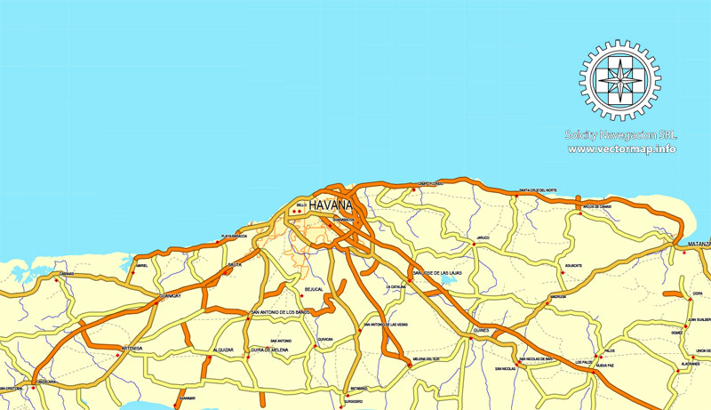
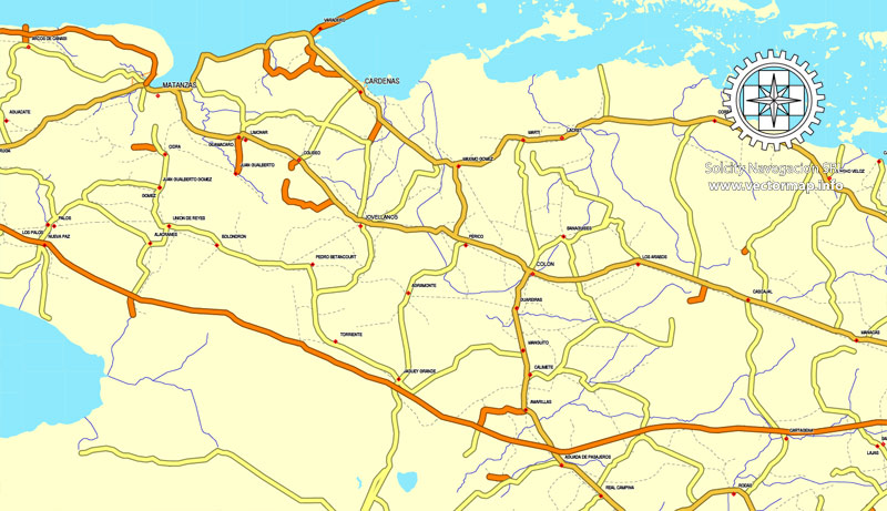
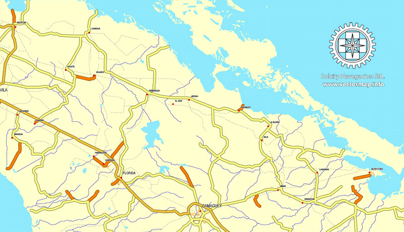
Cuba Country vector map roads, Adobe Illustrator, North America
Archive size: 2,6 Mb, zipped .AI
DPI: 300
This vector maps of Cuba Country is created using 2016 data.
License: Royalty Free
Separated layers, all names in text format.
Good for print in ANY format = 2xA0
Cuba Country vector map roads, Adobe Illustrator format (.AI) features (check the preview images):
Highways, Major Roads, Big and small Rivers, small streams also, Lake, ponds and other water bodies.
Our maps can be suited to any size needed. Perfect for presentation or large size printing, like office walls (we are sure, Big Boss wants one of this) or bigboards. We provide detailed maps of Cuba in AI. Being vector maps, they are completely editable, you can add your company logo or change fonts style, line thickness or borders. Need more objects (POI) on map? We can add it with no extra fee. Separated layers, you can turn on or off layer needed.
Please also check other vector maps of Cuba we have.
Cuba.
This vector map of Cuba is used as a basis for design, editing, and further printing.
This is the most detailed, exact map of Cuba for high-quality printing and polygraphy. You can always clarify the map development date by contacting us.
For your convenience, all objects on Cuba vector map are divided into layers. And the editing is very easy – colors, lines, etc.
You can easily add any objects needed (e.g. shops, salons, sale points, gas station or attraction) on any layer of Cuba vector map.
Cuba officially the Republic of Cuba (Spanish: About this soundRepública de Cuba (help·info)), is a country comprising the island of Cuba as well as Isla de la Juventud and several minor archipelagos. Cuba is located in the northern Caribbean where the Caribbean Sea, Gulf of Mexico and Atlantic Ocean meet. It is east of the Yucatán Peninsula (Mexico), south of both the U.S. state of Florida and the Bahamas, west of Haiti and north of both Jamaica and the Cayman Islands. Havana is the largest city and capital; other major cities include Santiago de Cuba and Camagüey. The area of the Republic of Cuba is 110,860 square kilometres (42,800 sq mi) (109,884 square kilometres (42,426 sq mi) without the territorial waters). The island of Cuba is the largest island in Cuba and in the Caribbean, with an area of 105,006 square kilometres (40,543 sq mi), and the second-most populous after Hispaniola, with over 11 million inhabitants.
One of the advantages of Cuba vector maps of our production is the relevance of cartographic data, we constantly update all our products.
This vector map of Cuba is used by:
designers, layout designers, printers, advertisers and architects. Our product – vector maps – is designed for further editing and printing in large formats – from @Wall format (a few meters) to A-0 and A-1, A-2, A-3.
Cuba map in vector format is used for design, urban planning, presentations and media visualizations.
Advertising and presentation map of Cuba (usually the final designer marks the routes, and puts the client’s objects (shops, saloons, gas stations etc.)
The undoubted advantage is that people will NEVER throw out this advertising product – the map. In fact, as an advertising medium, a map is the most “long-playing” of the well-known polygraphic advertising media, with the longest lifespan, and the maximum number of interactions with the customer.
For travelers, maps are sold at the airports and gas stations around the world. Often the source is our vector maps.
Take a look, who purchases our vector maps of Cuba in “Our Clients and Friends” page – these are large and small companies, from super-brands like Volvo and Starbucks, to small design studios and printing houses.
It’s very easy to work with vector maps of Cuba, even for a not very experienced designer who can turn on and off the map layers, add new objects, change the colors of fill and lines according to customer requirements.
The undoubted advantage of Cuba vector maps in printing is an excellent and detailed visualization, when customer can expand a large paper map and instantly define his location, find a landmark, an object or address on map, unlike using the popular electronic formats of Google and Yandex maps for example.
The territory that is now Cuba was inhabited by the Ciboney Taíno people from the 4th millennium BC until Spanish colonisation in the 15th century. From the 15th century, it was a colony of Spain until the Spanish–American War of 1898, when Cuba was occupied by the United States and gained nominal independence as a de facto United States protectorate in 1902. As a fragile republic, in 1940 Cuba attempted to strengthen its democratic system, but mounting political radicalization and social strife culminated in a coup and subsequent dictatorship under Fulgencio Batista in 1952. Open corruption and oppression under Batista’s rule led to his ousting in January 1959 by the 26th of July Movement, which afterwards established communist rule under the leadership of Fidel Castro. Since 1965, the state has been governed by the Communist Party of Cuba. The country was a point of contention during the Cold War between the Soviet Union and the United States, and a nuclear war nearly broke out during the Cuban Missile Crisis of 1962. Cuba is one of few Marxist–Leninist socialist states, where the role of the vanguard Communist Party is enshrined in the Constitution. Independent observers have accused the Cuban government of numerous human rights abuses, including arbitrary imprisonment.
Printable vector maps of Cuba are much more convenient and efficient than any electronic maps on your smartphone, because ALL DETAILS are displayed in the entire space of Cuba map.
Useful tips on working with vector maps of cities and countries in Adobe Illustrator.
«V» – launches the Selection tool (cursor, black arrow), which makes active any vector line.
«А» – launches the Direct Selection tool (white cursor), allows you to select curve elements and drag them to the desired place.
«R» – activates the Rotate tool, which helps you rotating selected objects around the center point by 360 degrees.
«E» – gives you the opportunity to use the Eraser tool and erase unnecessary parts.
«X» – switches between Fill and Stroke in the Tools section. Try to get used to this hot key and
you will quickly understand that you can’t live and work without it.
Guides are not limited to vertical and horizontal in Adobe Illustrator. You can also create a diagonal guide for example. Moreover, you can turn any contours into guides. Select the outline and go to View > Guides > Make Guides (Create Guides), or simply press Cmd/Ctrl + 5. You can also turn the guides back into an editable object. Go to menu, View > Guides > Unlock Guides (Release Guides), select the guide you want to edit and select View > Guides > Release Guides (Reset Guides), or just press Cmd/Ctrl + Option / Alt + 5).
You will probably want to change the color scheme used on our Cuba vector map.
To quickly and effectively play with colors.
Of course, you can do it manually, all objects in our Cuba vector map are divided according to types and layers, and you can easily change the color gamma of vector objects in groups and layers.
But there is more effective way of working with the whole VECTOR MAP of Cuba and all layers:
The overview dialog «Edit colors»/«Repaint Graphic Object» (this dialog box name can change depending on the context):
If you have selected a part or a layer of Cuba vector map and open the dialog box by clicking the icon in the Control panel, on the Samples palette or the Color Catalog, or if you choose Edit > Edit Colors> Repaint Graphic Object, then the «Repaint Graphic Object» dialog box appears, and you get access to «Assign» and «Edit» tabs.
If a picture or a map fragment is not selected, and you open the dialog box by clicking the icon in the Control panel, on the Samples palette or in the Color Catalog, the «Edit Colors» dialog box appears and you can only access the «Edit» tab.
Regardless of the name at the top of the dialog box, the right-hand side always displays the color group of the current document, as well as two default color groups: Print Color and Grayscale. These color groups can be selected and used any time.
Create and edit color groups of Cuba vector map, and also assign colors using the «Edit Colors»/ а «Repaint Graphic Object» dialog box.
A. Creating and editing of a color group on the «Edit» tab
B. Assigning colors on the «Assign» tab
C. Select a group of colors from the «Color groups» list
The option «Repaint a graphic object» in the lower part of the dialog box allows you to preview the colors on a selected layer of Vector map, or a group of elements, and specify whether its colors will be redefined when the dialog box is closed.
The main areas of the dialog box are:
«Edit»
The «Edit» tab is designed to create a new or edit the existing color groups.
The harmony rules Menu and the Color Wheel are used to conduct experiments with color harmonies. The color wheel shows how colors are related in color harmony, and the color bars allow you to view and manipulate an individual color values. In addition, you can adjust the brightness, add and remove colors, save color groups and view colors on the selected Vector Map of Cuba or a separated layers.
«Assign»
The «Assign» tab is used to view and control on how the original colors are replaced with colors from the color group like your corporate colors in the Vector Map of Cuba.
The assign color ability is provided only if the entire map, layer or fragment is selected in the document. You can specify which of new colors replace the current colors, whether the spot colors should be preserved and how colors are replaced (for example, you can replace colors completely or changing the color tone while maintaining the brightness). The «Assign» tab allows you to redefine colors in the Vector Map of Cuba, or in separate layers and fragments using the current color group or reducing the number of colors in the current Vector Map.
Color groups
Is a list of all saved color groups for current document (the same groups appear in the «Samples» palette). You can edit and delete the existing color groups, as well as creating a new ones using the list of “Color Groups” in the dialog box. All changes appear in the «Samples» palette.
The highlighted color group shows, which color group is currently edited.
Culturally, Cuba is considered part of Latin America. It is a multiethnic country whose people, culture and customs derive from diverse origins, including the aboriginal Taíno and Ciboney peoples, the long period of Spanish colonialism, the introduction of African slaves and a close relationship with the Soviet Union in the Cold War.
Cuba is a sovereign state and a founding member of the United Nations, the G77, the Non-Aligned Movement, the African, Caribbean and Pacific Group of States, ALBA and Organization of American States. The country is a regional power in Latin America and a middle power in world affairs. It has currently one of the world’s only planned economies, and its economy is dominated by the exports of sugar, tobacco, coffee and skilled labor. According to the Human Development Index, Cuba has high human development and is ranked the eighth highest in North America, though 67th in the world. It also ranks highly in some metrics of national performance, including health care and education.
Any color group can be selected and edited, or used to redefine the colors in the selected vector map of Cuba, its fragments or elements.
Saving a color group adds this group to the specified list.
Opening the «Edit Colors»/«Repaint Graphic Object» dialog box.
Open the «Edit Colors»/«Repaint Graphic Object» dialog box using one of the following methods:
«Edit»> «Edit Colors»> «Repaint Graphic object» or «Repaint With Style».
Use these commands if you need to edit the colors in the selected vector map of Cuba.
«Repaint Graphic object» button on the «Control» panel.
Use this button if you need to adjust colors of Cuba vector map using the а «Repaint graphic object» dialog box.
The specified button is available if the selected vector map or its fragment contains two or more colors.
Note. This color editing method is convenient for global color adjustment in a vector map, if global colors were not used when creating a Map of Cuba.
The «Edit colors» button or «Edit or apply colors» on the «Color Catalog» palette
Click this button if you need to edit colors on the «Color Catalog» palette or edit and then apply them to the selected Vector Map of Cuba or its fragment.
The «Edit color group» button or «Edit or apply color group» on the «Samples» palette.
Click this button if you need to edit the colors in the specific color group or edit and apply them to the selected Vector Map of Cuba or a group of its elements, for example, the whole layer “Streets and lines”. You can also double-click the color group in the Samples panel to open the dialog box.
If the map file is too large and your computer freezes or even can’t open it quickly:
1. Try to reduce the color resolution of the video card (display) to 256 colors while working with a large map.
2. Using Windows Task Manager, select all the application you don’t need, while working with map, just turn them off.
3. Launch Adobe Illustrator. (DO NOT OPEN the vector map file)
4. Start the Windows Task Manager using administrator rights > Find the “Illustrator” process > set the «real time» priority,
5. Open the file. When you see the LEGACY FONT popup window – click “OK” (do not update). You can restore the TEXT later.
6. Can also be useful: When file is opened – Edit > Settings > Basic Settings > disable smoothing. /// It looks scary, but works quickly)))
We recommend saving the file in Adobe Illustrator 10 version. It’s much more stable when working with VERY BIG size files.
Geography
Cuba is an archipelago of islands located in the northern Caribbean Sea at the confluence with the Gulf of Mexico and the Atlantic Ocean. It lies between latitudes 19° and 24°N, and longitudes 74° and 85°W. The United States lies 150 kilometers (93 miles) across the Straits of Florida to the north and northwest (to the closest tip of Key West, Florida), and the Bahamas 21 km (13 mi) to the north. Mexico lies 210 kilometers (130 miles) across the Yucatán Channel to the west (to the closest tip of Cabo Catoche in the State of Quintana Roo).
Haiti is 77 km (48 mi) to the east, Jamaica (140 km/87 mi) and the Cayman Islands to the south. Cuba is the principal island, surrounded by four smaller groups of islands: the Colorados Archipelago on the northwestern coast, the Sabana-Camagüey Archipelago on the north-central Atlantic coast, the Jardines de la Reina on the south-central coast and the Canarreos Archipelago on the southwestern coast.
Sierra Maestra
The main island, named Cuba, is 1,250 km (780 mi) long, constituting most of the nation’s land area (104,556 km2 (40,369 sq mi)) and is the largest island in the Caribbean and 17th-largest island in the world by land area. The main island consists mostly of flat to rolling plains apart from the Sierra Maestra mountains in the southeast, whose highest point is Pico Turquino (1,974 m (6,476 ft)).
The second-largest island is Isla de la Juventud (Isle of Youth) in the Canarreos archipelago, with an area of 2,200 km2 (849 sq mi). Cuba has an official area (land area) of 109,884 km2 (42,426 sq mi). Its area is 110,860 km2 (42,803 sq mi) including coastal and territorial waters.
You can customize all map data using different vector graphics editors like: Adobe Illustrator, Freehand or CorelDraw, Autocad or Freehand. And also is a fully scalable map, no matter what size you need.
This vector map of Cuba Country is available in different vector formats (the same price): .AI, .CDR .DWG, .DXF, .EPS, .PDF.
Royalty Free license. You don`t pay extra: per volume sold; for each use; for period of use.
Cuba road map with big “zoom” without quality degradation. The difference between raster and vector is that vector can be adjusted to any size you need with NO quality loss. Perfect for large-size printing (walls & billboards, tourist map. business map).
Probably, you need more objects to be added? Just tell us, we don`t charge for this work.
Cuba Country road map vector, North America in vector.
Cuba Country Roads vector map for Adobe Illustrator. Purchasing and downloading.
Credit Card and PayPal payment accepted. After the payment you will be redirected to the download page.
We also offer custom mapping. If you need something special – just contact our friendly team.
Es: Cuba País mapa vectorial carreteras, Adobe Illustrator, América del Norte
Tamaño del archivo: 2,6 Mb, con cremallera .AI
DPI: 300
Este vector mapas de Cuba País usa la información de 2016.
Licencia: Libre de derechos
Capas separadas, todos los nombres en formato texto.
Bueno para la impresión en cualquier formato 2xA0 =
Cuba País mapa vectorial carreteras, formato Adobe Illustrator (.ai) cuenta (marcar las imágenes de vista previa):
Carreteras,
Principales carreteras,
Los ríos grandes y pequeños, pequeños arroyos también,
Lago, lagunas y otros cuerpos de agua.
Nuestros mapas pueden ser adaptados a cualquier tamaño necesario. Perfecto para la presentación o la impresión de gran tamaño, como paredes de la oficina (estamos seguros, Big Boss quiere uno de ello) o billboards. Proporcionamos mapas detallados de Cuba en la IA. Siendo mapas vectoriales, que son totalmente editable, puede añadir el logotipo de su empresa o cambiar las fuentes de estilo, grosor de línea o fronteras. ¿Necesitas más objetos (POI) en el mapa? Podemos añadir que sin ningún cargo extra. Capas separadas, se puede activar o desactivar la capa sea necesario.
Por favor, compruebe también otros mapas vectoriales de Cuba tenemos.
Usted puede personalizar todos los datos de los mapas utilizando diferentes editores de gráficos vectoriales como Adobe Illustrator, Freehand o CorelDraw, AutoCAD o Freehand. Y también es un mapa totalmente escalable, sin importar el tamaño que usted necesita.
Este mapa vectorial de Cuba País está disponible en diferentes formatos vectoriales (el mismo precio): .AI, .CDR .DWG, .DXF, .EPS, .PDF.
Imagen de archivo libre de licencia. Usted don `t pagar extra: por volumen vendido; para cada uso; para el período de uso.
Hoja de ruta Cuba con “zoom” grande sin degradación de la calidad. La diferencia entre raster y vector es que el vector se puede ajustar a cualquier tamaño que usted necesita sin pérdida de calidad. Perfecto para impresión de gran tamaño (paredes y vallas publicitarias, mapa turístico. Mapa de Negocios).
Probablemente, usted necesita más objetos que se añadirán? Sólo tienes que decirnos, ponemos el `t responsable de este trabajo.
Cuba País hoja de ruta del vector, América del Norte en el vector.
Cuba Country Roads mapa vectorial para Adobe Illustrator. Compras y descarga.
Tarjeta de crédito y pago de PayPal aceptaron. Después del pago usted será redirigido a la página de descarga.
También ofrecemos asignación personalizada. Si necesita algo especial – sólo en contacto con nuestro equipo.

 Author: Kirill Shrayber, Ph.D. FRGS