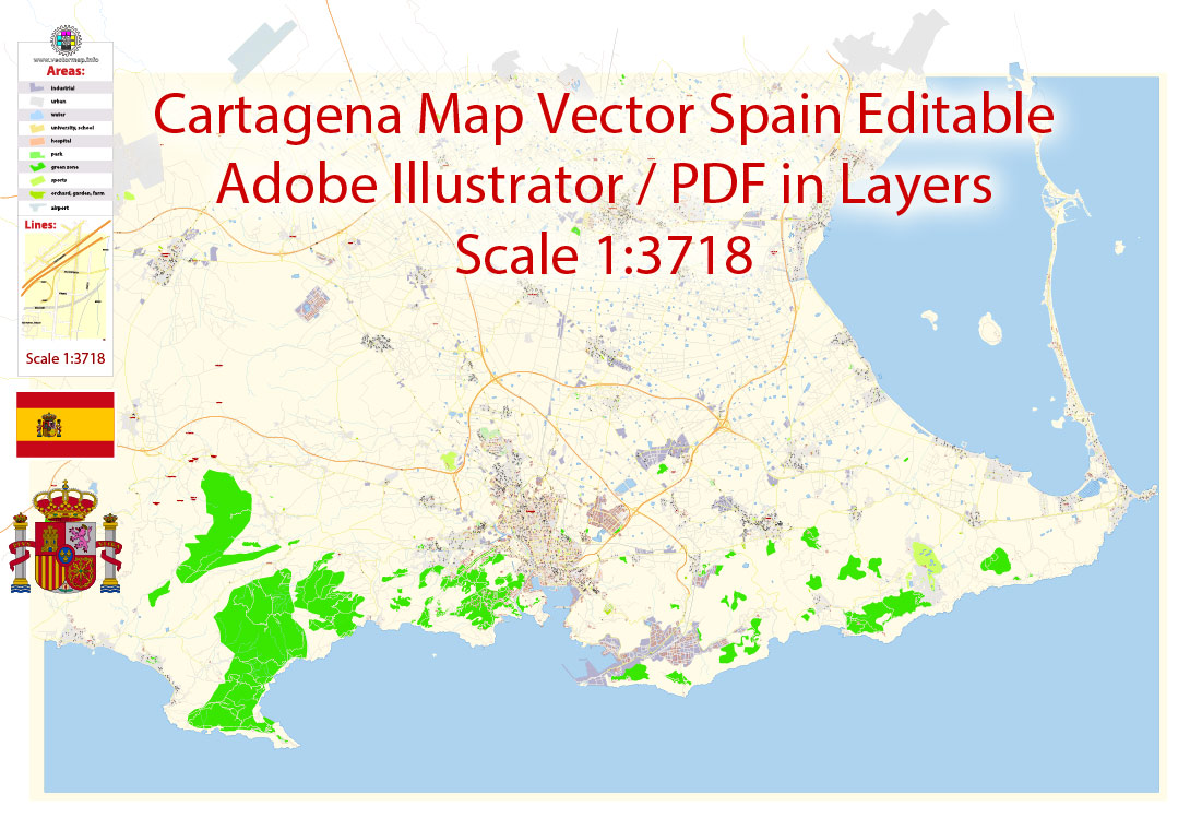
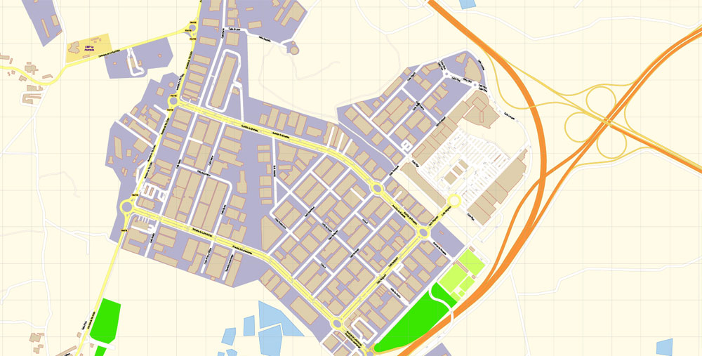
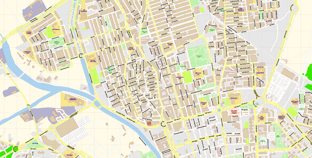
Printable PDF Vector Map Cartagena Spain exact extra detailed City Plan editable Adobe PDF scale 1:3718 Street Map in layers 19 Mb ZIP.
All streets names, main objects, buildings. Map for publishing, design, printing, publications, arts, projects, presentations, for architects, designers and builders, business, logistics. The most exact and detailed map of the city in scale
Layers: legend, grids, labels_roads, names_places, names_streets, names_objects, buikdings, streets_roads, color_fills, etc.
Text format all names
For Editing and High Quality Printing
DWG, DXF, CDR, ESRI Shapes, and other formats – by request, same price, please contact.
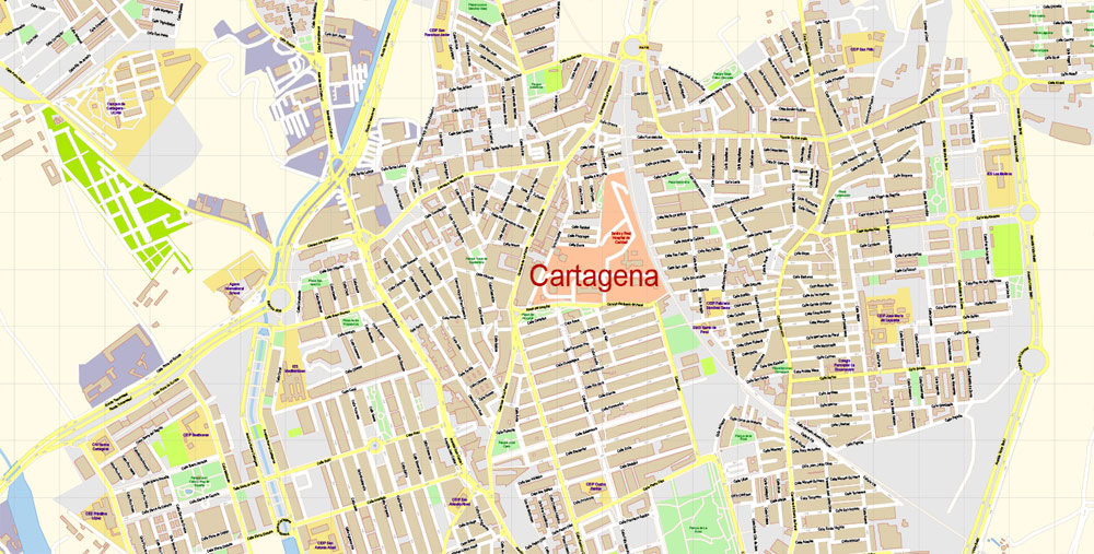
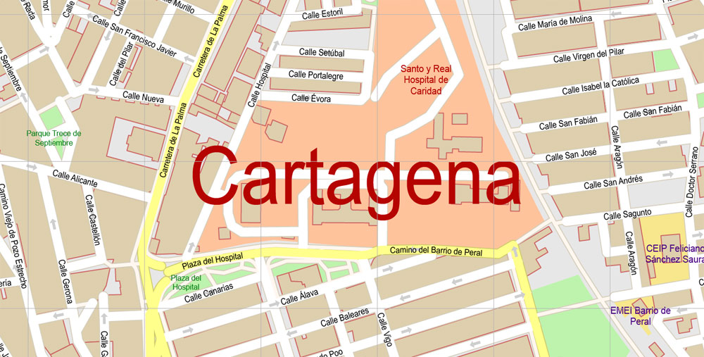
Cartagena, Spain
City in Spain
Cartagena is a port city and naval base in the Murcia region of southeast Spain. Founded by the Carthaginians around 220 B.C., the city boomed during the Roman period. Among its many Roman ruins are a 1st-century B.C. theater and Casa de la Fortuna, a villa with murals and mosaics. The Muralla Púnica (Punic Wall) interpretation center houses the remains of a 3rd-century B.C. defensive wall.
Area
• Total 558.08 km2 (215.48 sq mi)
Elevation 10 m (30 ft)
Highest elevation 50 m (160 ft)
Lowest elevation 0 m (0 ft)
Population
• Total 216,655
• Density 390/km2 (1,000/sq mi)
Time zone CET (UTC+1)
• Summer (DST) CEST (UTC+2)
Cartagena is a Spanish city and a major naval station located in the Region of Murcia, by the Mediterranean coast, south-eastern Spain. As of January 2011, it has a population of 218,210 inhabitants being the Region’s second largest municipality and the country’s 6th non-Province capital city. The metropolitan area of Cartagena, known as Campo de Cartagena, has a population of 409,586 inhabitants.
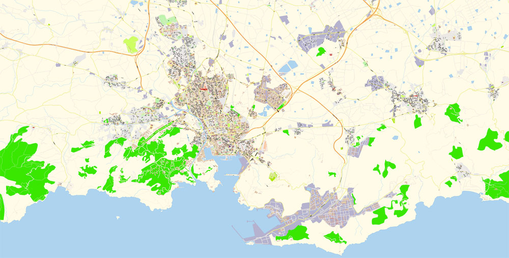
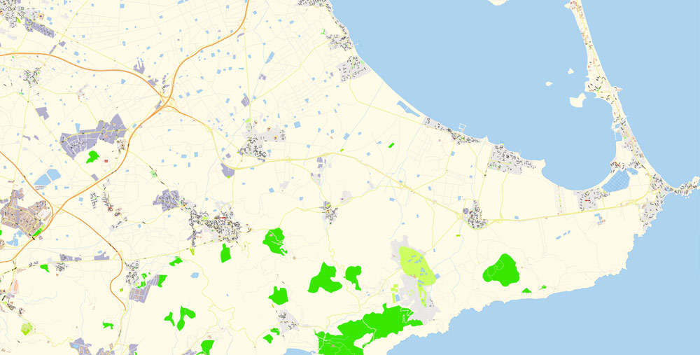
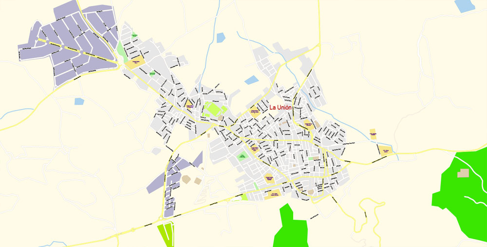
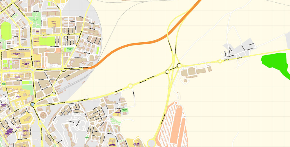
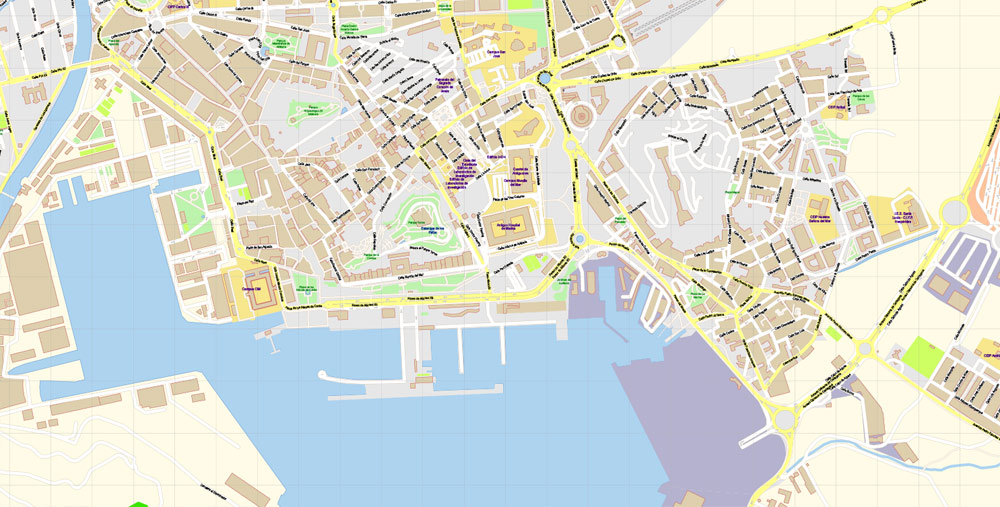
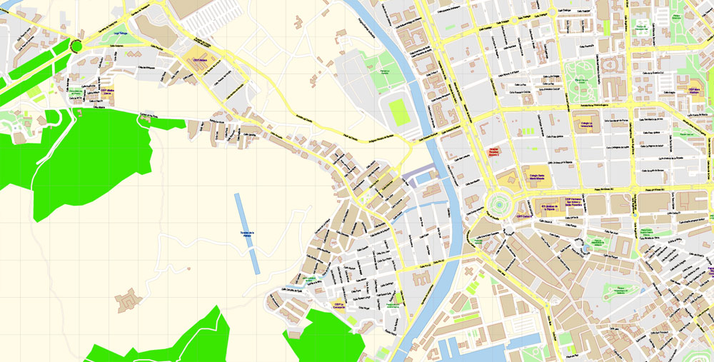
This vector map of Cartagena city is used as a basis for design, editing, and further printing.
This is the most detailed, exact map of Cartagena city for high-quality printing and polygraphy. You can always clarify the map development date by contacting us.
Cartagena has been inhabited for over two millennia, being founded around 227 BC by the Carthaginian Hasdrubal the Fair as Qart Hadasht (Phoenician, meaning ‘New Town’) the same name as the original city of Carthage. The city had its heyday during the Roman Empire, when it was known as Carthago Nova (the New Carthage) and Carthago Spartaria, capital of the province of Carthaginensis. It was one of the important cities during the Umayyad invasion of Hispania, under its Arabic name of Qartayannat al-Halfa.
For your convenience, all objects on Cartagena vector city map are divided into layers, and the editing is very easy – colors, lines, etc.
You can easily add any objects needed (e.g. shops, salons, sale points, gas station or attraction) on any layer of Cartagena vector map.
Much of the historical weight of Cartagena in the past goes to its coveted defensive port, one of the most important in the western Mediterranean. Cartagena has been the capital of the Spanish Navy’s Maritime Department of the Mediterranean since the arrival of the Spanish Bourbons in the 18th century. As far back as the 16th century it was one of the most important naval ports in Spain, together with Ferrol in the North. It is still an important naval seaport, the main military haven of Spain, and is home to a large naval shipyard.
Color groups
Is a list of all saved color groups for current document (the same groups appear in the «Samples» palette). You can edit and delete the existing color groups, as well as creating a new ones using the list of “Color Groups” in the dialog box. All changes appear in the «Samples» palette.
The highlighted color group shows, which color group is currently edited. Any color group can be selected and edited, or used to redefine the colors in the selected vector map of Cartagena city, its fragments or elements.
Saving a color group adds this group to the specified list.
Opening the «Edit Colors»/«Repaint Graphic Object» dialog box.
Open the «Edit Colors»/«Repaint Graphic Object» dialog box using one of the following methods:
«Edit»> «Edit Colors»> «Repaint Graphic object» or «Repaint With Style».
Use these commands if you need to edit the colors in the selected vector map of Cartagena city.
The main areas of the dialog box are:
«Edit»
The «Edit» tab is designed to create a new or edit the existing color groups.
The harmony rules Menu and the Color Wheel are used to conduct experiments with color harmonies. The color wheel shows how colors are related in color harmony, and the color bars allow you to view and manipulate an individual color values. In addition, you can adjust the brightness, add and remove colors, save color groups and view colors on the selected Vector Map of Cartagena city or a separated layers.
Assign
The «Assign» tab is used to view and control on how the original colors are replaced with colors from the color group like your corporate colors in the Vector Map of Cartagena city.
The assign color ability is provided only if the entire map, layer or fragment is selected in the document. You can specify which of new colors replace the current colors, whether the spot colors should be preserved and how colors are replaced (for example, you can replace colors completely or changing the color tone while maintaining the brightness). The «Assign» tab allows you to redefine colors in the Vector Map of Cartagena city, or in separate layers and fragments using the current color group or reducing the number of colors in the current Vector Map.
The confluence of civilizations as well as its strategic harbour, together with the rise of the local mining industry is manifested by a unique artistic heritage, with a number of landmarks such as the Roman Theatre, the second largest of the Iberian Peninsula after the one in Mérida, an abundance of Phoenician, Roman, Byzantine and Moorish remains, and a plethora of Art Nouveau buildings, a result of the bourgeoisie from the early 20th century. Cartagena is now established as a major cruise ship destination in the Mediterranean and an emerging cultural focus.
Useful tips on working with vector maps of cities and countries in Adobe Illustrator.
«V» – launches the Selection tool (cursor, black arrow), which makes active any vector line.
«А» – launches the Direct Selection tool (white cursor), allows you to select curve elements and drag them to the desired place.
«R» – activates the Rotate tool, which helps you rotating selected objects around the center point by 360 degrees.
«E» – gives you the opportunity to use the Eraser tool and erase unnecessary parts.
«X» – switches between Fill and Stroke in the Tools section. Try to get used to this hot key and
you will quickly understand that you can’t live and work without it.
Guides are not limited to vertical and horizontal in Adobe Illustrator. You can also create a diagonal guide for example. Moreover, you can turn any contours into guides. Select the outline and go to View > Guides > Make Guides (Create Guides), or simply press Cmd/Ctrl + 5. You can also turn the guides back into an editable object. Go to menu, View > Guides > Unlock Guides (Release Guides), select the guide you want to edit and select View > Guides > Release Guides (Reset Guides), or just press Cmd/Ctrl + Option / Alt + 5).
Geography and relief
The city of Cartagena is located in the southeastern region of Spain in the Campo de Cartagena. The Cartagena region can be viewed as a great plain inclined slightly in the direction NW-SE, bordered at the north and the northwest by pre-coastal mountain ranges (Carrascoy, El Puerto, Los Villares, Columbares and Escalona), and at the south and southwest by coastal mountain ranges (El Algarrobo, La Muela, Pelayo, Gorda, La Fausilla y Minera, with its last spurs in Cape Palos). The dominant geology of the region is metamorphic (slate, marble) and sedimentary (limestone).
One of the advantages of Cartagena city vector maps of our production is the relevance of cartographic data, we constantly update all our products.
This vector map of Cartagena city is used by:
designers, layout designers, printers, advertisers and architects. Our product – vector maps – is designed for further editing and printing in large formats – from @Wall format (a few meters) to A-0 and A-1, A-2, A-3.
The Cartagena city map in vector format is used for design, urban planning, presentations and media visualizations.
The city is located just at the end of the new AP-7 motorway. The following villages are part of Cartagena municipality: La Azohía, Isla Plana, Los Urrutias and Los Nietos.
The Old Town is limited by five small hills (Molinete, Monte Sacro, Monte de San José, Despeñaperros and Monte de la Concepción) following the example of Rome. In the past, there was an inner sea between the hills called the Estero that eventually dried up. On this site, the “Ensanche” (Expansion or New Town) was built at the beginning of the 20th century.
The advertising and presentation map of Cartagena city (usually the final designer marks the routes, and puts the client’s objects (shops, saloons, gas stations etc.)
The undoubted advantage is that people will NEVER throw out this advertising product – the map. In fact, as an advertising medium, a city map is the most “long-playing” of the well-known polygraphic advertising media, with the longest lifespan, and the maximum number of interactions with the customer.
For travelers, maps are sold at the airports amd gas stations around the world. Often the source is our vector maps.
Take a look, who purchases our vector maps of Cartagena city in “Our Clients and Friends” page – these are large and small companies, from super-brands like Volvo and Starbucks, to small design studios and printing houses.
The urban area is delimited or crossed by several watercourses, some of which go deep into the urban network during a large part of their courses.
It’s very easy to work with vector maps of Cartagena city, even for a not very experienced designer who can turn on and off the map layers, add new objects, change the colors of fill and lines according to customer requirements.
The undoubted advantage of Cartagena city vector maps in printing is an excellent and detailed visualization, when customer can expand a large paper map and instantly define his location, find a landmark, an object or address on map, unlike using the popular electronic formats of Google and Yandex maps for example.
Create and edit color groups of Cartagena city vector map, and also assign colors using the «Edit Colors»/ а «Repaint Graphic Object» dialog box.
A. Creating and editing of a color group on the «Edit» tab
B. Assigning colors on the «Assign» tab
C. Select a group of colors from the «Color groups» list
The option «Repaint a graphic object» in the lower part of the dialog box allows you to preview the colors on a selected layer of Vector map, or a group of elements, and specify whether its colors will be redefined when the dialog box is closed.
«Repaint Graphic object» button on the «Control» panel.
Use this button if you need to adjust colors of Cartagena city vector map using the а «Repaint graphic object» dialog box.
The specified button is available if the selected vector map or its fragment contains two or more colors.
Note. This color editing method is convenient for global color adjustment in a vector map, if global colors were not used when creating a City Map of Cartagena.
Printable vector maps of Cartagena city is much more convenient and efficient than any electronic maps on your smartphone, because ALL DETAILS are displayed in the entire space of Cartagena city map.
You will probably want to change the color scheme used on our Cartagena vector city map.
To quickly and effectively play with colors.
Of course, you can do it manually, all objects in our Cartagena city vector map are divided according to types and layers, and you can easily change the color gamma of vector objects in groups and layers.
But there is more effective way of working with the whole VECTOR MAP of Cartagena city and all layers:
The overview dialog «Edit colors»/«Repaint Graphic Object» (this dialog box name can change depending on the context):
If you have selected a part or a layer of Cartagena city vector map and open the dialog box by clicking the icon in the Control panel, on the Samples palette or the Color Catalog, or if you choose Edit > Edit Colors> Repaint Graphic Object, then the «Repaint Graphic Object» dialog box appears, and you get access to «Assign» and «Edit» tabs.
The «Edit colors» button or «Edit or apply colors» on the «Color Catalog» palette
Click this button if you need to edit colors on the «Color Catalog» palette or edit and then apply them to the selected Vector Map of Cartagena city or its fragment.
The «Edit color group» button or «Edit or apply color group» on the «Samples» palette.
Click this button if you need to edit the colors in the specific color group or edit and apply them to the selected Vector Map of Cartagena city or a group of its elements, for example, the whole layer “Streets and lines”. You can also double-click the color group in the Samples panel to open the dialog box.

If a picture or a map fragment is not selected, and you open the dialog box by clicking the icon in the Control panel, on the Samples palette or in the Color Catalog, the «Edit Colors» dialog box appears and you can only access the «Edit» tab.
Regardless of the name at the top of the dialog box, the right-hand side always displays the color group of the current document, as well as two default color groups: Print Color and Grayscale. These color groups can be selected and used any time.
If the map file is too large and your computer freezes or even can’t open it quickly:
1. Try to reduce the color resolution of the video card (display) to 256 colors while working with a large map.
2. Using Windows Task Manager, select all the application you don’t need, while working with map, just turn them off.
3. Launch Adobe Illustrator. (DO NOT OPEN the vector map file)
4. Start the Windows Task Manager using administrator rights > Find the “Illustrator” process > set the «real time» priority,
5. Open the file. When you see the LEGACY FONT popup window – click “OK” (do not update). You can restore the TEXT later.
6. ???? Can also be useful: ???? When the file is opened – Edit > Settings > Basic Settings > disable smoothing. /// It looks scary, but works quickly)))
We recommend saving the file in Adobe Illustrator 10 version. It’s much more stable when working with VERY BIG size files.

 Author: Kirill Shrayber, Ph.D. FRGS