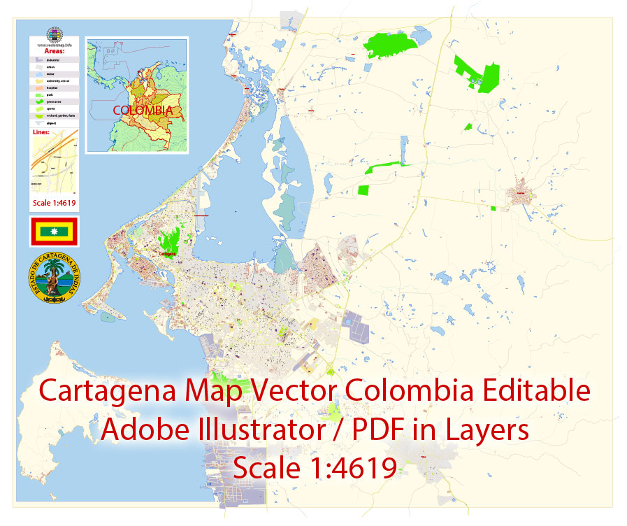
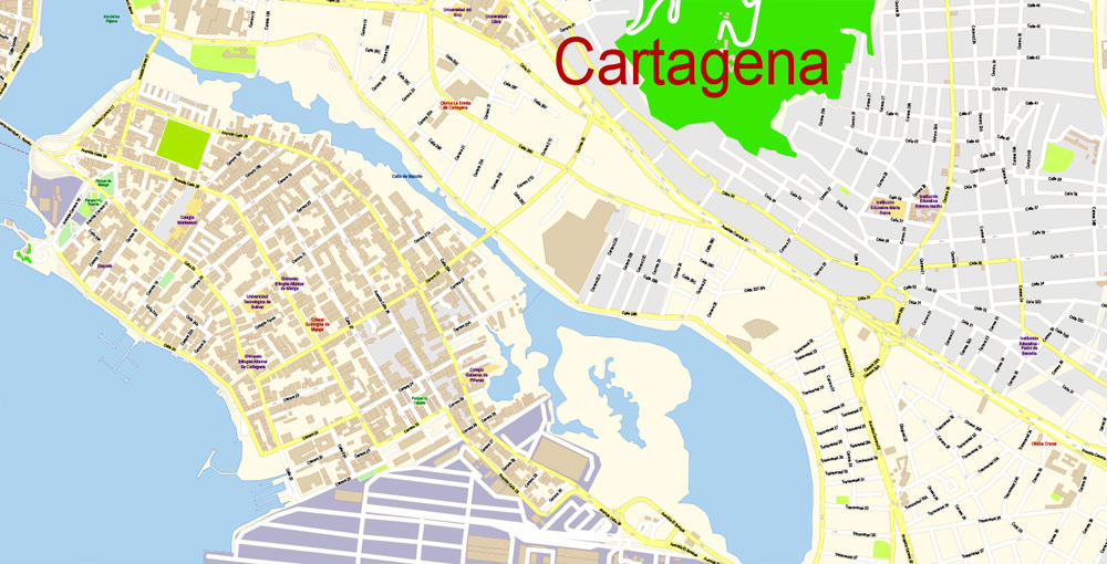
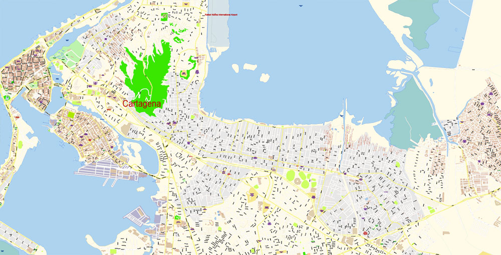
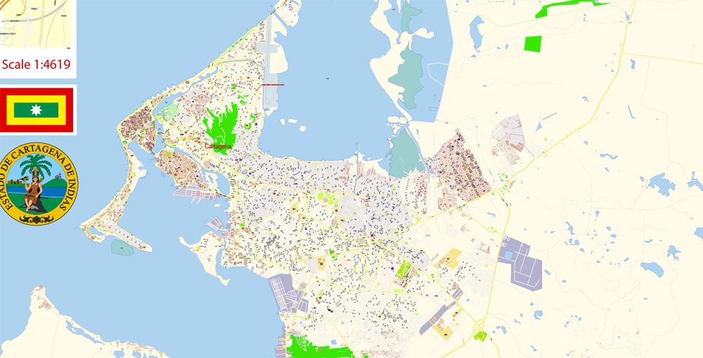
Printable PDF Vector Map Cartagena Colombia exact extra detailed City Plan editable Adobe PDF scale 1:4619 Street Map in layers 11 Mb ZIP.
All streets names, main objects, buildings. Map for publishing, design, printing, publications, arts, projects, presentations, for architects, designers and builders, business, logistics. The most exact and detailed map of the city in scale
Layers: legend, grids, labels_roads, names_places, names_streets, names_objects, buikdings, streets_roads, color_fills, etc.
Text format all names
For Editing and High Quality Printing
DWG, DXF, CDR, ESRI Shapes, and other formats – by request, same price, please contact.
Cartagena
City in Colombia
Cartagena is a port city on Colombia’s Caribbean coast. By the sea is the walled Old Town, founded in the 16th century, with squares, cobblestone streets and colorful colonial buildings. With a tropical climate, the city is also a popular beach destination. Reachable by boat are Isla de Barú, with white-sand beaches and palm trees, and the Islas del Rosario, known for their coral reefs.
Area
• City 572 km2 (221 sq mi)
Elevation 2 m (7 ft)
Population
• City 971,592
• Rank Ranked 5th
• Metro 1,013,389
Time zone COT (UTC-5)
Postal code 130000
Area code(s) 57 + 5
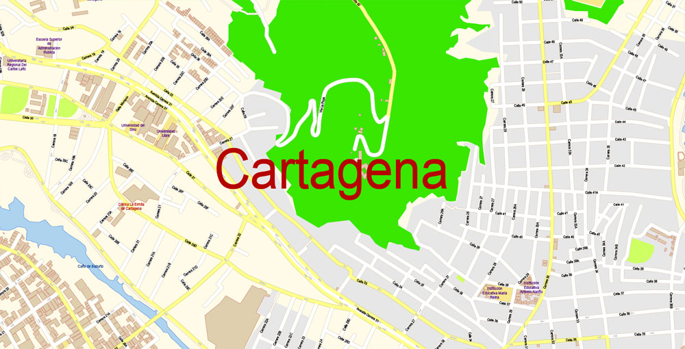
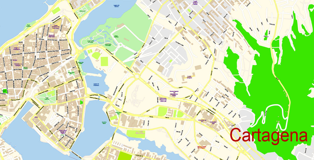
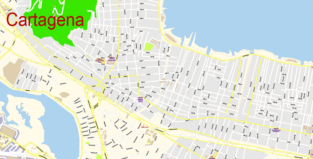
Cartagena (Cartagena de Indias) is the fifth-largest city in Colombia, the administrative center of the Bolivar Department, and a major port on the Caribbean coast. A well-fortified citadel of the XVII century is located on the island of Getsemani and the mainland cape, but the modern city includes other islands, as well as part of the mainland.
Cartagena de Indias was founded in 1533, and was one of the first Spanish settlements in the New World and the main port through which the wealth of the continent was exported to the metropolis. The city was a tasty morsel for British corsairs, who repeatedly tried to capture it in the XVI century. The most famous raid on Cartagena was led by the famous Francis Drake, who in 1586 captured the city, burned the cathedral and held hostages for more than a hundred days, demanding in return a colossal ransom for those times. The Spaniards did their best to secure such an important commercial port for them by building a complex system of fortifications around the outer contours of the city, which are now the main attraction of the city, the total length of the fortifications of Cartagena is more than 11 km.
The old town of Cartagena (Ciudad Amurallado), located in its northern part, is the most interesting. It is here that ancient forts and numerous colonial buildings are located. Ciudad Amurallado is divided into four zones: San Diego, La Matuna, Santo Domingo and Getsemani. In the Getsemani area there is the main fortress of Cartagena – Castillo de San Felipe de Barajas, the thickness of the walls of which reaches 12 m. Its construction was carried out in the period from 1533 to 1657. Here, in the Old Town, there is a vast Central Park and the oldest church of the city – Iglesia de Santo Domingo (1536).
Residential areas stretch in the southern part of Cartagena. The center of this area is the square of San Pedro Claver, on which stands the Cathedral (1575-1602). Nearby is Bolivar Square with a monument to the first President of Colombia, an Archaeological Museum and the Palace of the Inquisition (1770). In Cartagena, it is also worth visiting the former Las Beauvedas prison of the 16th century, where an extensive shopping area is now located, the convent of the Convent de La Popa of the 16th century (now a Historical Museum), the Old Port and the promenade with chic villas and restaurants.
In 1980, the historical monuments of Cartagena (the fortress, the main square with the cathedral, St. Peter’s Church, the Inquisition Palace, the university building) were declared a UNESCO World Heritage Site.
South of the Getsemani area on the peninsula is the recreation area of Bocagrande and El Lagunito. Here, sandy beaches stretch along the coast, along which there are hotels, restaurants, bars and discos. The Playa Blanca coast is one of the best beach areas in Colombia.
Those who want to relax on quiet picturesque beaches away from the hustle and bustle of the city should go to the islands of Rosario and San Bernardo, located 40 km south of Cartagena, or to the island of Baru. Rosario and San Bernardo Islands National Park is the only underwater park in the country. It covers an area of 19500 hectares. Its main attraction is the underwater world, which attracts diving and snorkeling enthusiasts from all over the world. The islands of del Rosario and Baru offer many diving spots that cannot be missed. Of particular note are Bancos de Salmedina, Bajo Burbujas, and “Montagna submarine” (deer-horned corals, sea feathers and black corals predominate here); El Faro, Octubre Rojo, Pendales, Tesoro Island, El Aparecido and La Coca – in these places “sea whips” corals are often found, and the bottom is mainly covered with turbinarias. The main infrastructure facilities of the National Park are located on the island of Isla Grande. Diving can also be done in the vicinity of the nearby island of Baru, which is surrounded by coral gardens.
Another 40 km south of the islands of Rosario and San Bernardo, the Morrosquillo Bay with the archipelago of the same name stretches along the coast. Its islands of Keitsen, Tintipan, and Mukura are surrounded by some of the most beautiful coral reefs, catsharks, dolphins, turtles and a variety of tropical fish live in the local waters.
Gallery of Images “Urban plan Cartagena Colombia”:
This vector map of Cartagena city is used as a basis for design, editing, and further printing.
This is the most detailed, exact map of Cartagena city for high-quality printing and polygraphy. You can always clarify the map development date by contacting us.
The city of Cartagena, known in the colonial era as Cartagena de Indias, is a major port founded in 1533, located on the northern coast of Colombia in the Caribbean Coast Region. It was strategically located between the Magdalena and Sinú rivers and became the main port for trade between Spain and its overseas empire, establishing its importance by the early 1540s. During the colonial era it was a key port for the export of Peruvian silver to Spain and for the import of enslaved Africans under the asiento system. It was defensible against pirate attacks in the Caribbean. It is the capital of the Bolívar Department, and had a population 971,592 as of 2016. It is the fifth-largest city in Colombia and the second largest in the region, after Barranquilla. The urban area of Cartagena is also the fifth-largest urban area in the country. Economic activities include the maritime and petrochemicals industries, as well as tourism.
For your convenience, all objects on Cartagena vector city map are divided into layers, and the editing is very easy – colors, lines, etc.
You can easily add any objects needed (e.g. shops, salons, sale points, gas station or attraction) on any layer of Cartagena vector map.
The city was founded on June 1, 1533, and named after Cartagena, Spain, which in turn was named after Carthage in Tunisia. Settlement in the region around Cartagena Bay by various indigenous people dates back to 4000 BC. During the Spanish colonial period Cartagena served a key role in administration and expansion of the Spanish empire. It was a center of political, ecclesiastical, and economic activity. In 1984, Cartagena’s colonial walled city and fortress were designated a UNESCO World Heritage Site.
Location
Cartagena faces the Caribbean Sea to the west. To the south is the Cartagena Bay, which has two entrances: Bocachica (Small Mouth) in the south, and Bocagrande (Big Mouth) in the north. Cartagena is located at 10°25′ North, 75°32′ West (10.41667, −75.5333).
Neighborhoods
The metropolitan area of Cartagena is formed by:
Northern area
In this area is the Rafael Núñez International Airport, located in the neighborhood of Crespo, ten minutes’ drive from downtown or the old part of the city and fifteen minutes away from the modern area. Zona Norte, the area located immediately north of the airport contains the Hotel Las Americas, the urban development office of Barcelona de Indias, and several educational institutions.
Downtown
One of the advantages of Cartagena city vector maps of our production is the relevance of cartographic data, we constantly update all our products.
The Downtown area of Cartagena has varied architecture, mainly a colonial style, but republican and Italian style buildings, such as the Cathedral’s bell tower, can be seen.
The main entrance to downtown is the Puerta del Reloj (Clock Gate), which exits onto the Plaza de los Coches (Square of the Carriages). A few steps farther is the Plaza de la Aduana (Customs Square), next to the mayor’s office. Nearby is San Pedro Claver Square and the church also named for Saint Peter Claver, where the body of the Jesuit saint (‘Saint of the African slaves’) is kept in a casket, as well as the Museum of Modern Art.
This vector map of Cartagena city is used by:
designers, layout designers, printers, advertisers and architects. Our product – vector maps – is designed for further editing and printing in large formats – from @Wall format (a few meters) to A-0 and A-1, A-2, A-3.
Nearby is the Plaza de Bolívar (Bolívar’s Square) and the Palace of Inquisition. Plaza de Bolívar (formerly known as Plaza de La Inquisicion) is essentially a small park with a statue of Simón Bolívar in the center. This plaza is surrounded by balconied colonial buildings. Shaded outdoor cafes line the street.
Use these commands if you need to edit the colors in the selected vector map of Cartagena city.
«Repaint Graphic object» button on the «Control» panel.
Use this button if you need to adjust colors of Cartagena city vector map using the а «Repaint graphic object» dialog box.
The specified button is available if the selected vector map or its fragment contains two or more colors.
Note. This color editing method is convenient for global color adjustment in a vector map, if global colors were not used when creating a City Map of Cartagena.
The «Edit colors» button or «Edit or apply colors» on the «Color Catalog» palette
Click this button if you need to edit colors on the «Color Catalog» palette or edit and then apply them to the selected Vector Map of Cartagena city or its fragment.
The Office of Historical Archives devoted to Cartagena’s history is not far away. Next to the archives is the Government Palace, the office building of the Governor of the Department of Bolivar. Across from the palace is the Cathedral of Cartagena, which dates back to the 16th century.
Another religious building of significance is the Iglesia de Santo Domingo in front of Plaza Santo Domingo (Santo Domingo Square). In the square is the sculpture Mujer Reclinada (“Reclining Woman”), a gift from the notable Colombian artist Fernando Botero. Nearby is the Tcherassi Hotel, a 250-year-old colonial mansion renovated by designer Silvia Tcherassi.
If a picture or a map fragment is not selected, and you open the dialog box by clicking the icon in the Control panel, on the Samples palette or in the Color Catalog, the «Edit Colors» dialog box appears and you can only access the «Edit» tab.
Regardless of the name at the top of the dialog box, the right-hand side always displays the color group of the current document, as well as two default color groups: Print Color and Grayscale. These color groups can be selected and used any time.
In the city is the Augustinian Fathers Convent and the University of Cartagena. This university is a center of higher education opened to the public in the late 19th century. The Claustro de Santa Teresa (Saint Theresa Cloister), which has been remodeled and has become a hotel operated by Charleston Hotels. It has its own square, protected by the San Francisco Bastion.
Create and edit color groups of Cartagena city vector map, and also assign colors using the «Edit Colors»/ а «Repaint Graphic Object» dialog box.
A. Creating and editing of a color group on the «Edit» tab
B. Assigning colors on the «Assign» tab
C. Select a group of colors from the «Color groups» list
The option «Repaint a graphic object» in the lower part of the dialog box allows you to preview the colors on a selected layer of Vector map, or a group of elements, and specify whether its colors will be redefined when the dialog box is closed.
The main areas of the dialog box are:
«Edit»
The «Edit» tab is designed to create a new or edit the existing color groups.
The harmony rules Menu and the Color Wheel are used to conduct experiments with color harmonies. The color wheel shows how colors are related in color harmony, and the color bars allow you to view and manipulate an individual color values. In addition, you can adjust the brightness, add and remove colors, save color groups and view colors on the selected Vector Map of Cartagena city or a separated layers.
The Cartagena city map in vector format is used for design, urban planning, presentations and media visualizations.
The advertising and presentation map of Cartagena city (usually the final designer marks the routes, and puts the client’s objects (shops, saloons, gas stations etc.)
The undoubted advantage is that people will NEVER throw out this advertising product – the map. In fact, as an advertising medium, a city map is the most “long-playing” of the well-known polygraphic advertising media, with the longest lifespan, and the maximum number of interactions with the customer.
You will probably want to change the color scheme used on our Cartagena vector city map.
To quickly and effectively play with colors.
Of course, you can do it manually, all objects in our Cartagena city vector map are divided according to types and layers, and you can easily change the color gamma of vector objects in groups and layers.
But there is more effective way of working with the whole VECTOR MAP of Cartagena city and all layers:
The overview dialog «Edit colors»/«Repaint Graphic Object» (this dialog box name can change depending on the context):
If you have selected a part or a layer of Cartagena city vector map and open the dialog box by clicking the icon in the Control panel, on the Samples palette or the Color Catalog, or if you choose Edit > Edit Colors> Repaint Graphic Object, then the «Repaint Graphic Object» dialog box appears, and you get access to «Assign» and «Edit» tabs.
A 20-minute walk from downtown is the Castillo de San Felipe de Barajas, located in el Pie de la Popa (another neighborhood), the greatest fortress ever built by the Spaniards in their colonies. The tunnels were all constructed in such a way as to make it possible to hear footsteps of an approaching enemy. Some of the tunnels are open for viewing today.
San Diego
San Diego was named after the local San Diego Convent, now known as the Beaux Arts University Building. In front of it is the Convent of the Nuns of the Order of Saint Clare, now the Hotel Santa Clara. In the surrounding area is Santo Toribio Church, the last church built in the Walled City. Next to it is Fernández de Madrid Square, honoring Cartagena’s hero, José Fernández de Madrid, whose statue can be seen nearby.
For travelers, maps are sold at the airports amd gas stations around the world. Often the source is our vector maps.
Inside the Old City is found Las Bóvedas (The Vaults), a construction attached to the walls of the Santa Catalina Fortress. From the top of this construction the Caribbean Sea is visible.
Getsemaní
A view of the Colonial and traditional neighbourhood of Getsemaní, usually found old houses painted with graffiti.
Take a look, who purchases our vector maps of Cartagena city in “Our Clients and Friends” page – these are large and small companies, from super-brands like Volvo and Starbucks, to small design studios and printing houses.
It’s very easy to work with vector maps of Cartagena city, even for a not very experienced designer who can turn on and off the map layers, add new objects, change the colors of fill and lines according to customer requirements.
Once a district characterized by crime, Getsemani, just south of the ancient walled fortress, has become “Cartagena’s hippest neighborhood and one of Latin America’s newest hotspots”, with plazas that were once the scene of drug dealing being reclaimed and old buildings being turned into boutique hotels.
Bocagrande
The undoubted advantage of Cartagena city vector maps in printing is an excellent and detailed visualization, when customer can expand a large paper map and instantly define his location, find a landmark, an object or address on map, unlike using the popular electronic formats of Google and Yandex maps for example.
Printable vector maps of Cartagena city is much more convenient and efficient than any electronic maps on your smartphone, because ALL DETAILS are displayed in the entire space of Cartagena city map.
The Bocagrande (Big Mouth) is an area known for its skyscrapers. The area contains the bulk of the city’s tourist facilities, such as hotels, shops, restaurants, nightclubs and art galleries. It is located between Cartagena Bay to the east and the Caribbean Sea to the west, and includes the two neighborhoods of El Laguito (The Little Lake) and Castillogrande (Big Castle). Bocagrande has long beaches and much commercial activity is found along Avenida San Martín (Saint Martin Avenue).
Useful tips on working with vector maps of cities and countries in Adobe Illustrator.
«V» – launches the Selection tool (cursor, black arrow), which makes active any vector line.
«А» – launches the Direct Selection tool (white cursor), allows you to select curve elements and drag them to the desired place.
«R» – activates the Rotate tool, which helps you rotating selected objects around the center point by 360 degrees.
«E» – gives you the opportunity to use the Eraser tool and erase unnecessary parts.
«X» – switches between Fill and Stroke in the Tools section. Try to get used to this hot key and
you will quickly understand that you can’t live and work without it.
The beaches of Bocagrande, lying along the northern shore, are made of volcanic sand, which is slightly grayish in color. This makes the water appear muddy, though it is not. There are breakwaters about every 200 yards (180 m).
Guides are not limited to vertical and horizontal in Adobe Illustrator. You can also create a diagonal guide for example. Moreover, you can turn any contours into guides. Select the outline and go to View > Guides > Make Guides (Create Guides), or simply press Cmd/Ctrl + 5. You can also turn the guides back into an editable object. Go to menu, View > Guides > Unlock Guides (Release Guides), select the guide you want to edit and select View > Guides > Release Guides (Reset Guides), or just press Cmd/Ctrl + Option / Alt + 5).
On the bay side of the peninsula of Bocagrande is a seawalk. In the center of the bay is a statue of the Virgin Mary. The Naval Base is also located in Bocagrande, looking at the Bay.
Assign
The «Assign» tab is used to view and control on how the original colors are replaced with colors from the color group like your corporate colors in the Vector Map of Cartagena city.
The assign color ability is provided only if the entire map, layer or fragment is selected in the document. You can specify which of new colors replace the current colors, whether the spot colors should be preserved and how colors are replaced (for example, you can replace colors completely or changing the color tone while maintaining the brightness). The «Assign» tab allows you to redefine colors in the Vector Map of Cartagena city, or in separate layers and fragments using the current color group or reducing the number of colors in the current Vector Map.
Color groups
Is a list of all saved color groups for current document (the same groups appear in the «Samples» palette). You can edit and delete the existing color groups, as well as creating a new ones using the list of “Color Groups” in the dialog box. All changes appear in the «Samples» palette.
The highlighted color group shows, which color group is currently edited. Any color group can be selected and edited, or used to redefine the colors in the selected vector map of Cartagena city, its fragments or elements.
Saving a color group adds this group to the specified list.
Opening the «Edit Colors»/«Repaint Graphic Object» dialog box.
Open the «Edit Colors»/«Repaint Graphic Object» dialog box using one of the following methods:
«Edit»> «Edit Colors»> «Repaint Graphic object» or «Repaint With Style».
The «Edit color group» button or «Edit or apply color group» on the «Samples» palette.
Click this button if you need to edit the colors in the specific color group or edit and apply them to the selected Vector Map of Cartagena city or a group of its elements, for example, the whole layer “Streets and lines”. You can also double-click the color group in the Samples panel to open the dialog box.
If the map file is too large and your computer freezes or even can’t open it quickly:
1. Try to reduce the color resolution of the video card (display) to 256 colors while working with a large map.
2. Using Windows Task Manager, select all the application you don’t need, while working with map, just turn them off.
3. Launch Adobe Illustrator. (DO NOT OPEN the vector map file)
4. Start the Windows Task Manager using administrator rights > Find the “Illustrator” process > set the «real time» priority,
5. Open the file. When you see the LEGACY FONT popup window – click “OK” (do not update). You can restore the TEXT later.
6. ???? Can also be useful: ???? When the file is opened – Edit > Settings > Basic Settings > disable smoothing. /// It looks scary, but works quickly)))
We recommend saving the file in Adobe Illustrator 10 version. It’s much more stable when working with VERY BIG size files.

 Author: Kirill Shrayber, Ph.D. FRGS