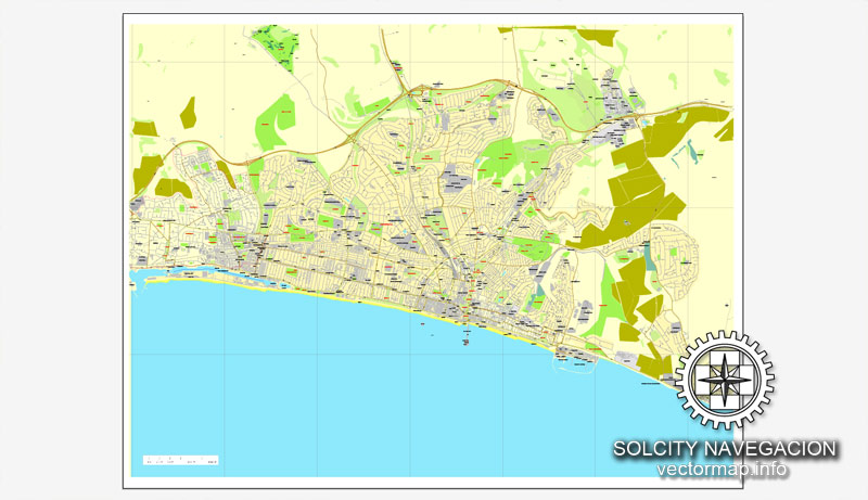
Brighton, England, UK Great Britain, printable vector street City Plan map, full editable, Adobe Illustrator, full vector, scalable, editable, text format street names, 1,4 mb ZIP
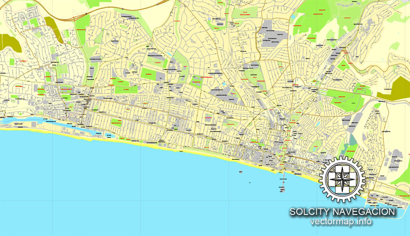
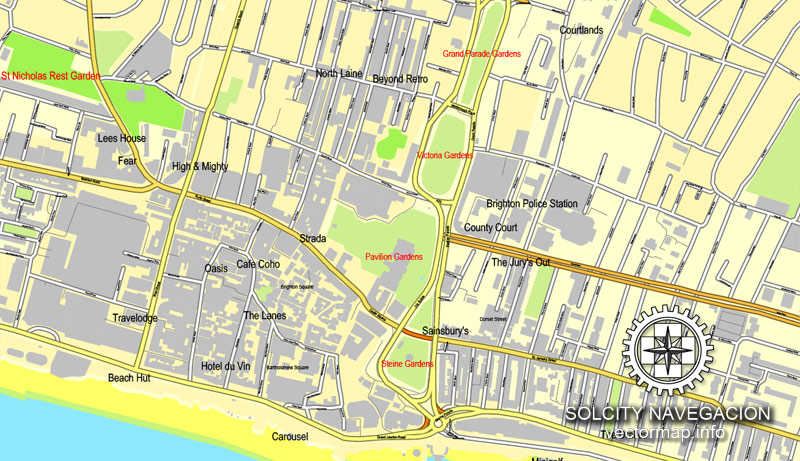
All streets, more buildings. Map for design, print, arts, projects, presentations.
DXF, DWG, CDR and other formats – on request, same price, please, contact
Brighton, England.
This vector map of Brighton is used as a basis for design, editing, and further printing.
This is the most detailed, exact map of Brighton for high-quality printing and polygraphy. You can always clarify the map development date by contacting us.
For your convenience, all objects on Brighton vector map are divided into layers. And the editing is very easy – colors, lines, etc.
You can easily add any objects needed (e.g. shops, salons, sale points, gas station or attraction) on any layer of Brighton vector map.
Brighton is a seaside resort on the south coast of England that is part of the city of Brighton and Hove, located 47 miles (76 km) south of London.
Archaeological evidence of settlement in the area dates back to the Bronze Age, Roman and Anglo-Saxon periods. The ancient settlement of “Brighthelmstone” was documented in the Domesday Book (1086). The town’s importance grew in the Middle Ages as the Old Town developed, but it languished in the early modern period, affected by foreign attacks, storms, a suffering economy and a declining population. Brighton began to attract more visitors following improved road transport to London and becoming a boarding point for boats travelling to France. The town also developed in popularity as a health resort for sea bathing as a purported cure for illnesses.
One of the advantages of Brighton vector maps of our production is the relevance of cartographic data, we constantly update all our products.
This vector map of Brighton is used by:
designers, layout designers, printers, advertisers and architects. Our product – vector maps – is designed for further editing and printing in large formats – from @Wall format (a few meters) to A-0 and A-1, A-2, A-3.
Brighton map in vector format is used for design, urban planning, presentations and media visualizations.
Advertising and presentation map of Brighton (usually the final designer marks the routes, and puts the client’s objects (shops, saloons, gas stations etc.)
The undoubted advantage is that people will NEVER throw out this advertising product – the map. In fact, as an advertising medium, a map is the most “long-playing” of the well-known polygraphic advertising media, with the longest lifespan, and the maximum number of interactions with the customer.
For travelers, maps are sold at the airports and gas stations around the world. Often the source is our vector maps.
Take a look, who purchases our vector maps of Brighton in “Our Clients and Friends” page – these are large and small companies, from super-brands like Volvo and Starbucks, to small design studios and printing houses.
In the Georgian era, Brighton developed as a fashionable seaside resort, encouraged by the patronage of the Prince Regent, later King George IV, who spent much time in the town and constructed the Royal Pavilion in the Regency era. Brighton continued to grow as a major centre of tourism following the arrival of the railways in 1841, becoming a popular destination for day-trippers from London. Many of the major attractions were built in the Victorian era, including the Metropole Hotel (now Hilton) Grand Hotel, the West Pier, and the Brighton Palace Pier. The town continued to grow into the 20th century, expanding to incorporate more areas into the town’s boundaries before joining the town of Hove to form the unitary authority of Brighton and Hove in 1997, which was granted city status in 2000. Today, Brighton and Hove district has a resident population of about 288,200 and the wider Brighton and Hove conurbation has a population of 474,485 (2011 census).
It’s very easy to work with vector maps of Brighton, even for a not very experienced designer who can turn on and off the map layers, add new objects, change the colors of fill and lines according to customer requirements.
The undoubted advantage of Brighton vector maps in printing is an excellent and detailed visualization, when customer can expand a large paper map and instantly define his location, find a landmark, an object or address on map, unlike using the popular electronic formats of Google and Yandex maps for example.
Printable vector maps of Brighton are much more convenient and efficient than any electronic maps on your smartphone, because ALL DETAILS are displayed in the entire space of Brighton map.
Useful tips on working with vector maps of cities and countries in Adobe Illustrator.
«V» – launches the Selection tool (cursor, black arrow), which makes active any vector line.
«А» – launches the Direct Selection tool (white cursor), allows you to select curve elements and drag them to the desired place.
«R» – activates the Rotate tool, which helps you rotating selected objects around the center point by 360 degrees.
«E» – gives you the opportunity to use the Eraser tool and erase unnecessary parts.
«X» – switches between Fill and Stroke in the Tools section. Try to get used to this hot key and
you will quickly understand that you can’t live and work without it.
Guides are not limited to vertical and horizontal in Adobe Illustrator. You can also create a diagonal guide for example. Moreover, you can turn any contours into guides. Select the outline and go to View > Guides > Make Guides (Create Guides), or simply press Cmd/Ctrl + 5. You can also turn the guides back into an editable object. Go to menu, View > Guides > Unlock Guides (Release Guides), select the guide you want to edit and select View > Guides > Release Guides (Reset Guides), or just press Cmd/Ctrl + Option / Alt + 5).
You will probably want to change the color scheme used on our Brighton vector map.
To quickly and effectively play with colors.
Of course, you can do it manually, all objects in our Brighton vector map are divided according to types and layers, and you can easily change the color gamma of vector objects in groups and layers.
But there is more effective way of working with the whole VECTOR MAP of Brighton and all layers:
The overview dialog «Edit colors»/«Repaint Graphic Object» (this dialog box name can change depending on the context):
If you have selected a part or a layer of Brighton vector map and open the dialog box by clicking the icon in the Control panel, on the Samples palette or the Color Catalog, or if you choose Edit > Edit Colors> Repaint Graphic Object, then the «Repaint Graphic Object» dialog box appears, and you get access to «Assign» and «Edit» tabs.
If a picture or a map fragment is not selected, and you open the dialog box by clicking the icon in the Control panel, on the Samples palette or in the Color Catalog, the «Edit Colors» dialog box appears and you can only access the «Edit» tab.
Regardless of the name at the top of the dialog box, the right-hand side always displays the color group of the current document, as well as two default color groups: Print Color and Grayscale. These color groups can be selected and used any time.
Create and edit color groups of Brighton vector map, and also assign colors using the «Edit Colors»/ а «Repaint Graphic Object» dialog box.
A. Creating and editing of a color group on the «Edit» tab
B. Assigning colors on the «Assign» tab
C. Select a group of colors from the «Color groups» list
The option «Repaint a graphic object» in the lower part of the dialog box allows you to preview the colors on a selected layer of Vector map, or a group of elements, and specify whether its colors will be redefined when the dialog box is closed.
The main areas of the dialog box are:
«Edit»
The «Edit» tab is designed to create a new or edit the existing color groups.
The harmony rules Menu and the Color Wheel are used to conduct experiments with color harmonies. The color wheel shows how colors are related in color harmony, and the color bars allow you to view and manipulate an individual color values. In addition, you can adjust the brightness, add and remove colors, save color groups and view colors on the selected Vector Map of Brighton or a separated layers.
«Assign»
The «Assign» tab is used to view and control on how the original colors are replaced with colors from the color group like your corporate colors in the Vector Map of Brighton.
The assign color ability is provided only if the entire map, layer or fragment is selected in the document. You can specify which of new colors replace the current colors, whether the spot colors should be preserved and how colors are replaced (for example, you can replace colors completely or changing the color tone while maintaining the brightness). The «Assign» tab allows you to redefine colors in the Vector Map of Brighton, or in separate layers and fragments using the current color group or reducing the number of colors in the current Vector Map.
Color groups
Is a list of all saved color groups for current document (the same groups appear in the «Samples» palette). You can edit and delete the existing color groups, as well as creating a new ones using the list of “Color Groups” in the dialog box. All changes appear in the «Samples» palette.
The highlighted color group shows, which color group is currently edited.
Any color group can be selected and edited, or used to redefine the colors in the selected vector map of Brighton, its fragments or elements.
Saving a color group adds this group to the specified list.
Opening the «Edit Colors»/«Repaint Graphic Object» dialog box.
Open the «Edit Colors»/«Repaint Graphic Object» dialog box using one of the following methods:
«Edit»> «Edit Colors»> «Repaint Graphic object» or «Repaint With Style».
Use these commands if you need to edit the colors in the selected vector map of Brighton.
«Repaint Graphic object» button on the «Control» panel.
Use this button if you need to adjust colors of Brighton vector map using the а «Repaint graphic object» dialog box.
The specified button is available if the selected vector map or its fragment contains two or more colors.
Note. This color editing method is convenient for global color adjustment in a vector map, if global colors were not used when creating a Map of Brighton.
The «Edit colors» button or «Edit or apply colors» on the «Color Catalog» palette
Click this button if you need to edit colors on the «Color Catalog» palette or edit and then apply them to the selected Vector Map of Brighton or its fragment.
The «Edit color group» button or «Edit or apply color group» on the «Samples» palette.
Click this button if you need to edit the colors in the specific color group or edit and apply them to the selected Vector Map of Brighton or a group of its elements, for example, the whole layer “Streets and lines”. You can also double-click the color group in the Samples panel to open the dialog box.
If the map file is too large and your computer freezes or even can’t open it quickly:
1. Try to reduce the color resolution of the video card (display) to 256 colors while working with a large map.
2. Using Windows Task Manager, select all the application you don’t need, while working with map, just turn them off.
3. Launch Adobe Illustrator. (DO NOT OPEN the vector map file)
4. Start the Windows Task Manager using administrator rights > Find the “Illustrator” process > set the «real time» priority,
5. Open the file. When you see the LEGACY FONT popup window – click “OK” (do not update). You can restore the TEXT later.
6. Can also be useful: When file is opened – Edit > Settings > Basic Settings > disable smoothing. /// It looks scary, but works quickly)))
We recommend saving the file in Adobe Illustrator 10 version. It’s much more stable when working with VERY BIG size files.
Brighton’s location has made it a popular destination for tourists, renowned for its diverse communities, quirky shopping areas, large cultural, music and arts scene and its large LGBT population, leading to its recognition as the “unofficial gay capital of the UK”. Brighton attracted 7.5 million day visitors in 2015/16 and 4.9 million overnight visitors, and is the most popular seaside destination in the UK for overseas tourists. Brighton has also been called the UK’s “hippest city”, and “the happiest place to live in the UK”.
Geography and topography
Brighton lies between the South Downs and the English Channel to the north and south, respectively. The Sussex coast forms a wide, shallow bay between the headlands of Selsey Bill and Beachy Head; Brighton developed near the centre of this bay around a seasonal river, the Wellesbourne (or Whalesbone), which flowed from the South Downs above Patcham. This emptied into the English Channel at the beach near the East Cliff, forming “the natural drainage point for Brighton”.
Behind the estuary was a stagnant pond called the Pool or Poole, so named since the medieval era. This was built over with houses and shops from 1793, when the Wellesbourne was culverted to prevent flooding, and only the name of the road (Pool Valley, originally Pool Lane) marks its site. One original house survives from the time of the pool’s enclosure. Behind Pool Valley is Old Steine (historically The Steyne), originally a flat and marshy area where fishermen dried their nets. The Wellesbourne occasionally reappears during times of prolonged heavy rain; author Mark Antony Lower referred to an early 19th-century drawing of the Royal Pavilion showing “quite a pool of water across the Steyne”.
Despite 16th-century writer Andrew Boorde’s claim that “Bryght-Hempston among the noble ports and havens of the realm”, Brighton never developed as a significant port: rather, it was considered as part of Shoreham. Nevertheless, the descriptions “Port of Brighthelmston” or “Port of Brighton” were sometimes used between the 14th and 19th centuries, as for example in 1766 when its notional limits were defined for customs purposes.
The East Cliff runs for several miles from Pool Valley towards Rottingdean and Saltdean, reaching 24 metres (80 ft) above sea level. The soil beneath it, a mixture of alluvium and clay with some flint and chalk rubble, has experienced erosion for many years. The cliff itself, like the rest of Brighton’s soil, is chalk. Below this are thin layers of Upper and Lower Greensand separated by a thicker band of Gault clay. The land slopes upwards gradually from south to north towards the top of the Downs.
Main transport links developed along the floor of the Wellesbourne valley, from which the land climbs steeply—particularly on the east side. The earliest settlement was by the beach at the bottom of the valley, which was partly protected from erosion by an underwater shale-bar. Changes in sea level affected the foreshore several times: 40 acres (16 ha) disappeared in the first half of the 14th century, and the Great Storm of 1703 caused widespread destruction. The first sea defences were erected in 1723, and a century later a long sea-wall was built.
Small guide: How to work with the vector map?
You can: Mass select objects by type and color – for example, the objects type “building” (they are usually dark gray) – and remove them from the map, if you do not need them in your print or design project. You can also easily change the thickness of lines (streets), just bulk selection the road by the line color.
The streets are separated by type, for example, type “residential road” are usually white with a gray stroke. Highway usually orange with a brown or dark gray stroke.
It is easy to change the font of inscriptions, all or each individually. Also, just can be make and any other manipulation of objects on the vector map in Adobe illustrator format.
Important: All the proportions on the map are true, that is, the relative sizes of the objects are true, because Map is based on an accurate GPS projection, and It transated into the (usual for all) the Mercator projection.
You can easily change the color, stroke and fill of any object on the map, zoom without loss of quality Image Verification.
Select object

Bulk selection the same objects on the vector map

See the bulk selected objects on the vector map

Bulk delete buildungs from the vector map

Select residencial road (small street) on the vector map

Bulk selection the same lines (streets, roads) on the full map

Create fat lines of the streets on the vector maps (bulk action) 1

Create fat lines of the streets on the vector maps (bulk action) 2

Create fat lines of the streets on the vector maps (bulk action) 3

You can easily change the color, stroke and fill of any object on the map, zoom without loss of quality Image Verification.
See also:
Brighton city street map in PDF, for large format printing
Printable street plan of Birmingham, in Adobe Illustrator

 Author: Kirill Shrayber, Ph.D. FRGS
 Street Map editable Adobe Illustrator in layers")
