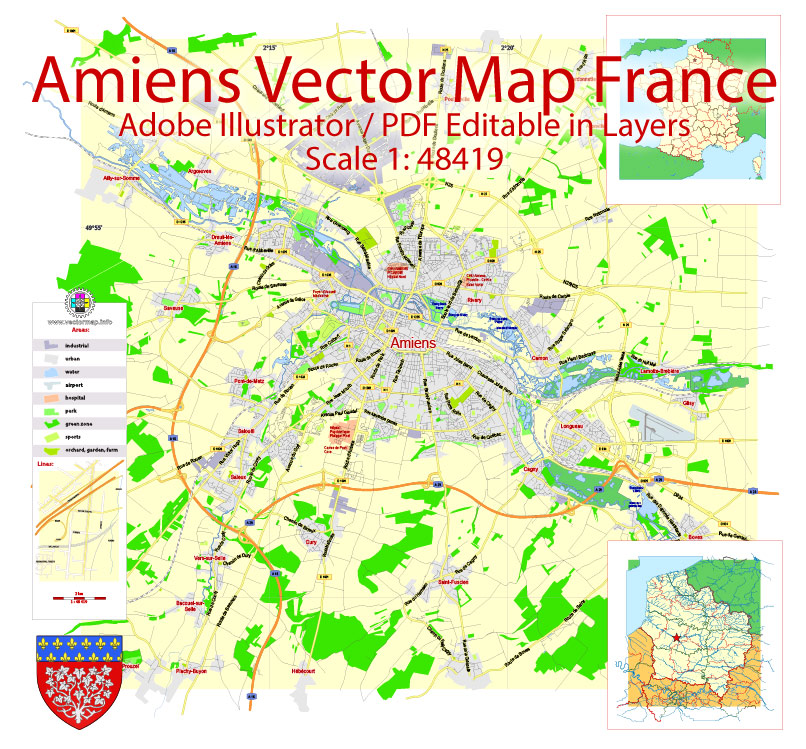
Printable Vector PDF Map Amiens France exact City Plan scale 1:48419 editable Adobe PDF Street Map in layers 8 Mb ZIP.
Principal streets names, main objects. Map for publishing, design, printing, publications, arts, projects, presentations, for architects, designers and builders, business, logistics. The most exact and detailed map of the city in scale
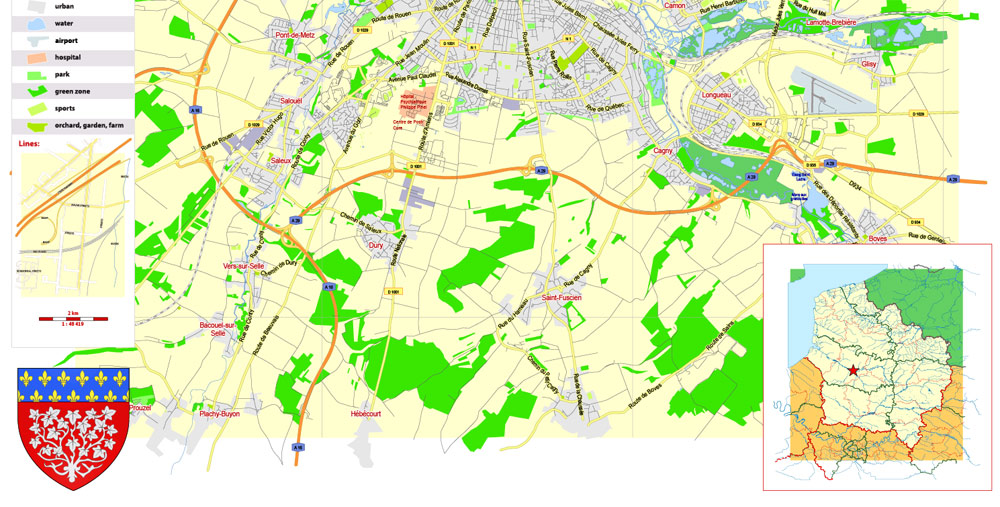
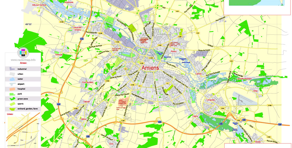
Layers: legend, grids, labels_roads, names_places, names_streets, names_objects, streets_roads, color_fills, etc.
Text format all names
For High Quality Printing
DWG, DXF, CDR, ESRI Shapes, and other formats – by request, same price, please contact.
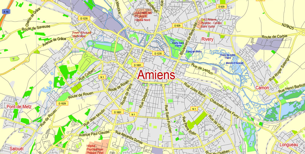
Amiens, France.
This vector map of Amiens city is used as a basis for design, editing, and further printing.
This is the most detailed, exact map of Amiens city for high-quality printing and polygraphy. You can always clarify the map development date by contacting us.
For your convenience, all objects on Amiens vector city map are divided into layers. And the editing is very easy – colors, lines, etc.
You can easily add any objects needed (e.g. shops, salons, sale points, gas station or attraction) on any layer of Amiens vector map.
One of the advantages of Amiens city vector maps of our production is the relevance of cartographic data, we constantly update all our products.
Amiens is a city and commune in northern France, 120 km (75 mi) north of Paris and 100 km (62 mi) south-west of Lille. It is the capital of the Somme department in Hauts-de-France. The city had a population of 136,105 according to the 2006 census.
This vector map of Amiens city is used by:
designers, layout designers, printers, advertisers and architects. Our product – vector maps – is designed for further editing and printing in large formats – from @Wall format (a few meters) to A-0 and A-1, A-2, A-3.
The Amiens city map in vector format is used for design, urban planning, presentations and media visualizations.
It has one of the biggest university hospitals in France with a capacity of 1,200 beds.
Amiens Cathedral, the tallest of the large, classic, Gothic churches of the 13th century and the largest in France of its kind, is a World Heritage Site. The author Jules Verne lived in Amiens from 1871 until his death in 1905, and served on the city council for 15 years. During December, the town hosts the largest Christmas market in northern France. Amiens is known for a few local foods, including “macarons d’Amiens”, almond paste biscuits; “tuiles amienoises”, chocolate and orange curved biscuits; “pâté de canard d’Amiens”, duck pâté in pastry; “la ficelle Picarde”, an oven-baked cheese-topped crêpe; and “flamiche aux poireaux”, a puff pastry tart made with leeks and cream.
The advertising and presentation map of Amiens city (usually the final designer marks the routes, and puts the client’s objects (shops, saloons, gas stations etc.)
The undoubted advantage is that people will NEVER throw out this advertising product – the map. In fact, as an advertising medium, a city map is the most “long-playing” of the well-known polygraphic advertising media, with the longest lifespan, and the maximum number of interactions with the customer.
For travelers, maps are sold at the airports and gas stations around the world. Often the source is our vector maps.
Take a look, who purchases our vector maps of Amiens city in “Our Clients and Friends” page – these are large and small companies, from super-brands like Volvo and Starbucks, to small design studios and printing houses.
Location
Map of the Amiens and its surrounding communes
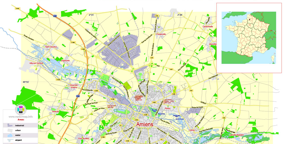
It’s very easy to work with vector maps of Amiens city, even for a not very experienced designer who can turn on and off the map layers, add new objects, change the colors of fill and lines according to customer requirements.
The undoubted advantage of Amiens city vector maps in printing is an excellent and detailed visualization, when customer can expand a large paper map and instantly define his location, find a landmark, an object or address on map, unlike using the popular electronic formats of Google and Yandex maps for example.
Amiens, the regional prefecture of Picardy, is also the prefecture of the Somme, one of the three departments (with Oise and Aisne) in the region. Located in the Paris Basin, across the country the city benefits from a privileged geographical position (proximity to Paris, Lille, Rouen, London and Brussels). At the crossroads of major European routes of movement (A1, A16 and A29), the city is also at the heart of a major rail star.
Printable vector maps of Amiens city are much more convenient and efficient than any electronic maps on your smartphone, because ALL DETAILS are displayed in the entire space of Amiens city map.
Useful tips on working with vector maps of cities and countries in Adobe Illustrator.
«V» – launches the Selection tool (cursor, black arrow), which makes active any vector line.
«А» – launches the Direct Selection tool (white cursor), allows you to select curve elements and drag them to the desired place.
«R» – activates the Rotate tool, which helps you rotating selected objects around the center point by 360 degrees.
«E» – gives you the opportunity to use the Eraser tool and erase unnecessary parts.
«X» – switches between Fill and Stroke in the Tools section. Try to get used to this hot key and
you will quickly understand that you can’t live and work without it.
As the crow flies, the city is 115 kilometres (71 mi) from Paris, 97 kilometres (60 mi) from Lille, 100 kilometres (62 mi) from Rouen, 162 kilometres (101 mi) from Le Havre and 144 kilometres (89 mi) from Reims. At the regional level, Amiens is located 53 kilometres (33 mi) north of Beauvais, 71 kilometres (44 mi) west of Saint-Quentin, 66 kilometres (41 mi) from Compiègne and 102 kilometres (63 mi) from Laon.
In area, it is the third in the Somme, after Crécy-en-Ponthieu and Hornoy-le-Bourg.
Geology and relief
The area of the commune is 4,946 hectares (12,220 acres); the altitude varies between 14 and 106 metres (46 and 348 ft).
Guides are not limited to vertical and horizontal in Adobe Illustrator. You can also create a diagonal guide for example. Moreover, you can turn any contours into guides. Select the outline and go to View > Guides > Make Guides (Create Guides), or simply press Cmd/Ctrl + 5. You can also turn the guides back into an editable object. Go to menu, View > Guides > Unlock Guides (Release Guides), select the guide you want to edit and select View > Guides > Release Guides (Reset Guides), or just press Cmd/Ctrl + Option / Alt + 5).
Saint-Leu quarter
St-Leu is a part of Amiens north of the city centre. It has many older wooden and brick houses and several canals. At the foot of the cathedral, traversed by canals, this picturesque area was largely rehabilitated during the 1990s. It extends to the Somme canal, located more to the north, at the foot of the Coteau Saint-Pierre on which the fortress of Jean Errard, called Citadelle, was built. Historically, it was the poor quarter of the city, where butchers, tanners and dyers gathered.
You will probably want to change the color scheme used on our Amiens vector city map.
To quickly and effectively play with colors.
Of course, you can do it manually, all objects in our Amiens city vector map are divided according to types and layers, and you can easily change the color gamma of vector objects in groups and layers.
But there is more effective way of working with the whole VECTOR MAP of Amiens city and all layers:
The overview dialog «Edit colors»/«Repaint Graphic Object» (this dialog box name can change depending on the context):
If you have selected a part or a layer of Amiens city vector map and open the dialog box by clicking the icon in the Control panel, on the Samples palette or the Color Catalog, or if you choose Edit > Edit Colors> Repaint Graphic Object, then the «Repaint Graphic Object» dialog box appears, and you get access to «Assign» and «Edit» tabs.
Amiens University’s Faculty of Sciences, present since the 1960s, has been renovated and expanded on occasion. The Faculty of Law and Economics has also been transferred since the mid-1990s from the campus (offset to the south of the city) to its new location at the foot of the cathedral. The open-air parking it replaces was a “gap” in the landscape dating from World War II. Nonetheless, it allowed an unobstructed view of the cathedral. Most of the buildings have been renovated and transformed into housing much of which is for students, many of whom are in the quarter.
If a picture or a map fragment is not selected, and you open the dialog box by clicking the icon in the Control panel, on the Samples palette or in the Color Catalog, the «Edit Colors» dialog box appears and you can only access the «Edit» tab.
Regardless of the name at the top of the dialog box, the right-hand side always displays the color group of the current document, as well as two default color groups: Print Color and Grayscale. These color groups can be selected and used any time.
Create and edit color groups of Amiens city vector map, and also assign colors using the «Edit Colors»/ а «Repaint Graphic Object» dialog box.
The area became the heart of the Amiens people’s evenings, with many establishments (bars, restaurants, etc.) on Place du Don and Quai Bélu.
At Rue Saint-Leu is found the church, located just between the Faculty of Science and Law-Economy (UPJV).
Two theatres were established in the quarter, that of the Chés Cabotans (puppet shows in the Picard language) and the Maison du Théâtre at the foot of the Saint-Leu Church. There is also La Lune des Pirates, a concert hall.
A. Creating and editing of a color group on the «Edit» tab
B. Assigning colors on the «Assign» tab
C. Select a group of colors from the «Color groups» list
The option «Repaint a graphic object» in the lower part of the dialog box allows you to preview the colors on a selected layer of Vector map, or a group of elements, and specify whether its colors will be redefined when the dialog box is closed.
The main areas of the dialog box are:
«Edit»
The «Edit» tab is designed to create a new or edit the existing color groups.
The harmony rules Menu and the Color Wheel are used to conduct experiments with color harmonies. The color wheel shows how colors are related in color harmony, and the color bars allow you to view and manipulate an individual color values. In addition, you can adjust the brightness, add and remove colors, save color groups and view colors on the selected Vector Map of Amiens city or a separated layers.
Saint-Maurice quarter
Located to the west of the Citadelle, and east of the La Madeleine Cemetery , this very old working-class quarter of Amiens, and industrial centre of the 18th century, is undergoing rehabilitation with the construction, rearrangement and renovation of much housing.
«Assign»
The «Assign» tab is used to view and control on how the original colors are replaced with colors from the color group like your corporate colors in the Vector Map of Amiens city.
The assign color ability is provided only if the entire map, layer or fragment is selected in the document. You can specify which of new colors replace the current colors, whether the spot colors should be preserved and how colors are replaced (for example, you can replace colors completely or changing the color tone while maintaining the brightness). The «Assign» tab allows you to redefine colors in the Vector Map of Amiens city, or in separate layers and fragments using the current color group or reducing the number of colors in the current Vector Map.
Bordered by the Canal de la Somme, it offers a stopover for leisure boats, which must go through a lock.
The walls of the city’s former dye factory are now those of the École supérieure d’art et de design d’Amiens (ESAD) as well as those of the Faculty of Arts. The École supérieure d’ingénieurs en électronique et électrotechnique (ESIEE) is in the same quarter. As the Citadelle, it will be renovated by the architect Renzo Piano to accommodate the university departments (UFR) of letters, of history and geography, of languages, the École supérieure du professorat et de l’éducation (ESPE), the House of Languages, the House of Research and the University Library in 2015.
Color groups
Is a list of all saved color groups for current document (the same groups appear in the «Samples» palette). You can edit and delete the existing color groups, as well as creating a new ones using the list of “Color Groups” in the dialog box. All changes appear in the «Samples» palette.
The highlighted color group shows, which color group is currently edited.
Any color group can be selected and edited, or used to redefine the colors in the selected vector map of Amiens city, its fragments or elements.
Saving a color group adds this group to the specified list.
Opening the «Edit Colors»/«Repaint Graphic Object» dialog box.
Open the «Edit Colors»/«Repaint Graphic Object» dialog box using one of the following methods:
«Edit»> «Edit Colors»> «Repaint Graphic object» or «Repaint With Style».
The Jardin des plantes, known as the Jardin du Roy within the city, is also located in this quarter.
Henriville-quarter
The Henriville neighbourhood was mostly built during the 19th century after the demolition of the city wall. It lies at the south of the town centre. It has numerous bourgeois houses and townhouses, predominantly in brick, blending architectural styles of the period, including neoclassical, troubadour and neo-Gothic. There are also private mansions, such as the Acloque mansion and the house of Jules Verne.
Use these commands if you need to edit the colors in the selected vector map of Amiens city.
«Repaint Graphic object» button on the «Control» panel.
Use this button if you need to adjust colors of Amiens city vector map using the а «Repaint graphic object» dialog box.
The specified button is available if the selected vector map or its fragment contains two or more colors.
Note. This color editing method is convenient for global color adjustment in a vector map, if global colors were not used when creating a City Map of Amiens.
Saint-Acheul quarter
The Saint-Acheul quarter existed before Amiens, as people have lived there since prehistoric times. This is where archaeological excavations in the nineteenth century discovered prehistoric tool sets typical of the “Acheulean” prehistorical era, named after this neighbourhood. An archaeological garden can be freely visited there.
The «Edit colors» button or «Edit or apply colors» on the «Color Catalog» palette
Click this button if you need to edit colors on the «Color Catalog» palette or edit and then apply them to the selected Vector Map of Amiens city or its fragment.
The «Edit color group» button or «Edit or apply color group» on the «Samples» palette.
Click this button if you need to edit the colors in the specific color group or edit and apply them to the selected Vector Map of Amiens city or a group of its elements, for example, the whole layer “Streets and lines”. You can also double-click the color group in the Samples panel to open the dialog box.
Not to be confused with the commune of Saint-Acheul situated 37 km (23 mi) to the north, the quarter of Saint-Acheul is the site of a military cemetery from the First World War (1914–1918).
It also contains the Church of Saint-Acheul, and the former normal school of teachers which became the Lycée Robert-de-Luzarches. A number of famous people are buried in the former Saint-Acheul cemetery such as J.-P. Pinchon (creator of Bécassine) and many resistance fighters. Part of the quarter includes a so-called “English neighbourhood,” with typical English style houses. At the feet of this area lie the hortillonnages, a marshy area criss-crossed by canals.
If the map file is too large and your computer freezes or even can’t open it quickly:
1. Try to reduce the color resolution of the video card (display) to 256 colors while working with a large map.
2. Using Windows Task Manager, select all the application you don’t need, while working with map, just turn them off.
3. Launch Adobe Illustrator. (DO NOT OPEN the vector map file)
4. Start the Windows Task Manager using administrator rights > Find the “Illustrator” process > set the «real time» priority,
5. Open the file. When you see the LEGACY FONT popup window – click “OK” (do not update). You can restore the TEXT later.
6. Can also be useful: When file is opened – Edit > Settings > Basic Settings > disable smoothing. /// It looks scary, but works quickly)))
We recommend saving the file in Adobe Illustrator 10 version. It’s much more stable when working with VERY BIG size files.
Other neighbourhoods
Amiens, like other big cities, has its large HLM high-rise tower blocks:
North of the city the quarters du Pigeonnier, which is famous for its weekend market, Messenger, Mozart, Fafet-Brossolette-la Cité, Balzac, Léo Lagrange-Schweitzer, etc.;
Southeast of the city: Victorine-Autier, Philéas Lebesgue, Condorcet, Pierre-Rollin.
West: Etouvie and Montieres (an ecodistrict is provided in this industrial space, where there are buildings of the 19th century, in brick).
East: Saint-Acheul-la-Cité and the Clos de l’Avre.
These areas experience a lot of social troubles and have regularly been the place for riots. The northern quarters were the scene of violent events in 1994, 1999 and 2000 (clashes between several districts of the city and between the neighbourhoods of Amiens and the districts of Creil), in 2006 and 2008 (in the wake of incidents in the Paris suburbs) and more recently in August 2012 following a conflict between youth and the police. The cost of the latest vandalism to occur in the north of Amiens would amount, according to Gilles Demailly, to between four and six million euros. These extremely violent riots caused sixteen police officers to be injured.
An extensive programme of redevelopment of these neighborhoods began recently, demolished HLM tower blocks and new infrastructure have been built, especially for schools. In 2009, the public transport network of the Amiens agglomeration was significantly modified.
Amiens is a city and commune in northern France, 120 km (75 mi) north of Paris and 100 km (62 mi) south-west of Lille. It is the capital of the Somme department in Hauts-de-France. The city had a population of 136,105 according to the 2006 census. It has one of the biggest university hospitals in France with a capacity of 1,200 beds. Amiens Cathedral, the tallest of the large, classic, Gothic churches of the 13th century and the largest in France of its kind, is a World Heritage Site. The author Jules Verne lived in Amiens from 1871 until his death in 1905, and served on the city council for 15 years. During December, the town hosts the largest Christmas market in northern France. Amiens is known for a few local foods, including “macarons d’Amiens”, almond paste biscuits; “tuiles amienoises”, chocolate and orange curved biscuits; “pâté de canard d’Amiens”, duck pâté in pastry; “la ficelle Picarde”, an oven-baked cheese-topped crêpe; and “flamiche aux poireaux”, a puff pastry tart made with leeks and cream.
Area 49.46 km2 (19.10 sq mi)
Population 132,479
• Density 2,700/km2 (6,900/sq mi)
Free vector maps:

Free download printable map Europe vector Adobe Illustrator >>>
Free download printable PDF map Europe vector Adobe PDF >>>

 Author: Kirill Shrayber, Ph.D. FRGS

