About vectorial Finland maps, Europe
Archive size: 5.5 Mb AI in ZIP
DPI: 300
License: Royalty Free
This vector map is available in just all possible formats: [.AI], [.DWG], [.PDF], [.EPS]; [.CDR], [.DXF]
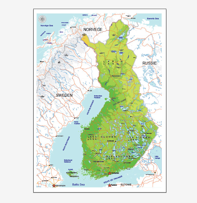
Finland vectorial map features (check the preview images before buying):
Highways
Major Roads,
National Park Borders,
Airports,
Big and small Rivers, small streams also,
Lake, ponds and other water bodies,
Landmark fill,
County Borders with fill,
Parks.
You can change fonts, colors of all objects mentioned above. Everything is editable. This layered vector map is scalable and can be adjusted to any size you need, no matter what big it is, with NO quality loss.
Please, CONTACT us, if you need some special POI to be inserted in vector maps of Finland.
Finland.
This vector map of Finland is used as a basis for design, editing, and further printing.
This is the most detailed, exact map of Finland for high-quality printing and polygraphy. You can always clarify the map development date by contacting us.
For your convenience, all objects on Finland vector map are divided into layers. And the editing is very easy – colors, lines, etc.
You can easily add any objects needed (e.g. shops, salons, sale points, gas station or attraction) on any layer of Finland vector map.
Finland is a country in Northern Europe bordering the Baltic Sea, Gulf of Bothnia, and Gulf of Finland, between Norway to the north, Sweden to the northwest, and Russia to the east. Finland is a Nordic country and is situated in the geographical region of Fennoscandia. The capital and largest city is Helsinki. Other major cities are Espoo, Vantaa, Tampere, Oulu and Turku.
One of the advantages of Finland vector maps of our production is the relevance of cartographic data, we constantly update all our products.
This vector map of Finland is used by:
designers, layout designers, printers, advertisers and architects. Our product – vector maps – is designed for further editing and printing in large formats – from @Wall format (a few meters) to A-0 and A-1, A-2, A-3.
The Finland map in vector format is used for design, urban planning, presentations and media visualizations.
The advertising and presentation map of Finland (usually the final designer marks the routes, and puts the client’s objects (shops, saloons, gas stations etc.)
The undoubted advantage is that people will NEVER throw out this advertising product – the map. In fact, as an advertising medium, a map is the most “long-playing” of the well-known polygraphic advertising media, with the longest lifespan, and the maximum number of interactions with the customer.
For travelers, maps are sold at the airports and gas stations around the world. Often the source is our vector maps.
Take a look, who purchases our vector maps of Finland in “Our Clients and Friends” page – these are large and small companies, from super-brands like Volvo and Starbucks, to small design studios and printing houses.
It’s very easy to work with vector maps of Finland city, even for a not very experienced designer who can turn on and off the map layers, add new objects, change the colors of fill and lines according to customer requirements.
The undoubted advantage of Finland vector maps in printing is an excellent and detailed visualization, when customer can expand a large paper map and instantly define his location, find a landmark, an object or address on map, unlike using the popular electronic formats of Google and Yandex maps for example.
Printable vector maps of Finland are much more convenient and efficient than any electronic maps on your smartphone, because ALL DETAILS are displayed in the entire space of Finland map.
Useful tips on working with vector maps of cities and countries in Adobe Illustrator.
«V» – launches the Selection tool (cursor, black arrow), which makes active any vector line.
«А» – launches the Direct Selection tool (white cursor), allows you to select curve elements and drag them to the desired place.
«R» – activates the Rotate tool, which helps you rotating selected objects around the center point by 360 degrees.
«E» – gives you the opportunity to use the Eraser tool and erase unnecessary parts.
«X» – switches between Fill and Stroke in the Tools section. Try to get used to this hot key and
you will quickly understand that you can’t live and work without it.
Guides are not limited to vertical and horizontal in Adobe Illustrator. You can also create a diagonal guide for example. Moreover, you can turn any contours into guides. Select the outline and go to View > Guides > Make Guides (Create Guides), or simply press Cmd/Ctrl + 5. You can also turn the guides back into an editable object. Go to menu, View > Guides > Unlock Guides (Release Guides), select the guide you want to edit and select View > Guides > Release Guides (Reset Guides), or just press Cmd/Ctrl + Option / Alt + 5).
You will probably want to change the color scheme used on our Finland vector map.
To quickly and effectively play with colors.
Of course, you can do it manually, all objects in our Finland vector map are divided according to types and layers, and you can easily change the color gamma of vector objects in groups and layers.
But there is more effective way of working with the whole VECTOR MAP of Finland and all layers:
The overview dialog «Edit colors»/«Repaint Graphic Object» (this dialog box name can change depending on the context):
If you have selected a part or a layer of Finland vector map and open the dialog box by clicking the icon in the Control panel, on the Samples palette or the Color Catalog, or if you choose Edit > Edit Colors> Repaint Graphic Object, then the «Repaint Graphic Object» dialog box appears, and you get access to «Assign» and «Edit» tabs.
If a picture or a map fragment is not selected, and you open the dialog box by clicking the icon in the Control panel, on the Samples palette or in the Color Catalog, the «Edit Colors» dialog box appears and you can only access the «Edit» tab.
Regardless of the name at the top of the dialog box, the right-hand side always displays the color group of the current document, as well as two default color groups: Print Color and Grayscale. These color groups can be selected and used any time.
Create and edit color groups of Finland vector map, and also assign colors using the «Edit Colors»/ а «Repaint Graphic Object» dialog box.
A. Creating and editing of a color group on the «Edit» tab
B. Assigning colors on the «Assign» tab
C. Select a group of colors from the «Color groups» list
The option «Repaint a graphic object» in the lower part of the dialog box allows you to preview the colors on a selected layer of Vector map, or a group of elements, and specify whether its colors will be redefined when the dialog box is closed.
The main areas of the dialog box are:
«Edit»
The «Edit» tab is designed to create a new or edit the existing color groups.
The harmony rules Menu and the Color Wheel are used to conduct experiments with color harmonies. The color wheel shows how colors are related in color harmony, and the color bars allow you to view and manipulate an individual color values. In addition, you can adjust the brightness, add and remove colors, save color groups and view colors on the selected Vector Map of Finland or a separated layers.
«Assign»
The «Assign» tab is used to view and control on how the original colors are replaced with colors from the color group like your corporate colors in the Vector Map of Finland city.
The assign color ability is provided only if the entire map, layer or fragment is selected in the document. You can specify which of new colors replace the current colors, whether the spot colors should be preserved and how colors are replaced (for example, you can replace colors completely or changing the color tone while maintaining the brightness). The «Assign» tab allows you to redefine colors in the Vector Map of Finland city, or in separate layers and fragments using the current color group or reducing the number of colors in the current Vector Map.
Color groups
Is a list of all saved color groups for current document (the same groups appear in the «Samples» palette). You can edit and delete the existing color groups, as well as creating a new ones using the list of “Color Groups” in the dialog box. All changes appear in the «Samples» palette.
The highlighted color group shows, which color group is currently edited.
Any color group can be selected and edited, or used to redefine the colors in the selected vector map of Finland city, its fragments or elements.
Saving a color group adds this group to the specified list.
Opening the «Edit Colors»/«Repaint Graphic Object» dialog box.
Open the «Edit Colors»/«Repaint Graphic Object» dialog box using one of the following methods:
«Edit»> «Edit Colors»> «Repaint Graphic object» or «Repaint With Style».
Use these commands if you need to edit the colors in the selected vector map of Finland city.
«Repaint Graphic object» button on the «Control» panel.
Use this button if you need to adjust colors of Finland vector map using the а «Repaint graphic object» dialog box.
The specified button is available if the selected vector map or its fragment contains two or more colors.
Note. This color editing method is convenient for global color adjustment in a vector map, if global colors were not used when creating a Map of Finland.
The «Edit colors» button or «Edit or apply colors» on the «Color Catalog» palette
Click this button if you need to edit colors on the «Color Catalog» palette or edit and then apply them to the selected Vector Map of Finland or its fragment.
The «Edit color group» button or «Edit or apply color group» on the «Samples» palette.
Click this button if you need to edit the colors in the specific color group or edit and apply them to the selected Vector Map of Finland or a group of its elements, for example, the whole layer “Streets and lines”. You can also double-click the color group in the Samples panel to open the dialog box.
If the map file is too large and your computer freezes or even can’t open it quickly:
1. Try to reduce the color resolution of the video card (display) to 256 colors while working with a large map.
2. Using Windows Task Manager, select all the application you don’t need, while working with map, just turn them off.
3. Launch Adobe Illustrator. (DO NOT OPEN the vector map file)
4. Start the Windows Task Manager using administrator rights > Find the “Illustrator” process > set the «real time» priority,
5. Open the file. When you see the LEGACY FONT popup window – click “OK” (do not update). You can restore the TEXT later.
6. Can also be useful: When file is opened – Edit > Settings > Basic Settings > disable smoothing. /// It looks scary, but works quickly)))
We recommend saving the file in Adobe Illustrator 10 version. It’s much more stable when working with VERY BIG size files.
Finland’s population is 5.52 million (2018), and the majority of the population is concentrated in the southern region. 88.7% of the population is Finnish and speaks Finnish, a Uralic language unrelated to the Scandinavian languages; next come the Finland-Swedes (5.3%). Finland is the eighth-largest country in Europe and the most sparsely populated country in the European Union. The sovereign state is a parliamentary republic with a central government based in the capital city of Helsinki, local governments in 311 municipalities, and one autonomous region, the Åland Islands. Over 1.4 million people live in the Greater Helsinki metropolitan area, which produces one third of the country’s GDP.
Finland was inhabited when the last ice age ended, approximately 9000 BCE. The first settlers left behind artefacts that present characteristics shared with those found in Estonia, Russia, and Norway. The earliest people were hunter-gatherers, using stone tools. The first pottery appeared in 5200 BCE, when the Comb Ceramic culture was introduced. The arrival of the Corded Ware culture in southern coastal Finland between 3000 and 2500 BCE may have coincided with the start of agriculture. The Bronze Age and Iron Age were characterised by extensive contacts with other cultures in the Fennoscandian and Baltic regions and the sedentary farming inhabitation increased towards the end of Iron Age. At the time Finland had three main cultural areas – Southwest Finland, Tavastia and Karelia – as reflected in contemporary jewellery.
From the late 13th century, Finland gradually became an integral part of Sweden through the Northern Crusades and the Swedish part-colonisation of coastal Finland, a legacy reflected in the prevalence of the Swedish language and its official status. In 1809, Finland was incorporated into the Russian Empire as the autonomous Grand Duchy of Finland. In 1906, Finland became the first European state to grant all adult citizens the right to vote, and the first in the world to give all adult citizens the right to run for public office.
Following the 1917 Russian Revolution, Finland declared itself independent. In 1918, the fledgling state was divided by civil war, with the Bolshevik-leaning Red Guard supported by the equally new Soviet Russia, fighting the White Guard, supported by the German Empire. After a brief attempt to establish a kingdom, the country became a republic. During World War II, the Soviet Union sought repeatedly to occupy Finland, with Finland losing parts of Karelia, Salla, Kuusamo, Petsamo and some islands, but retaining independence.
Finland joined the United Nations in 1955 and established an official policy of neutrality. The Finno-Soviet Treaty of 1948 gave the Soviet Union some leverage in Finnish domestic politics during the Cold War era. Finland joined the OECD in 1969, the NATO Partnership for Peace in 1994, the European Union in 1995, the Euro-Atlantic Partnership Council in 1997, and finally the Eurozone at its inception, in 1999.
Finland was a relative latecomer to industrialisation, remaining a largely agrarian country until the 1950s. After World War II, the Soviet Union demanded war reparations from Finland not only in money but also in material, such as ships and machinery. This forced Finland to industrialise. It rapidly developed an advanced economy while building an extensive welfare state based on the Nordic model, resulting in widespread prosperity and one of the highest per capita incomes in the world. Finland is a top performer in numerous metrics of national performance, including education, economic competitiveness, civil liberties, quality of life, and human development. In 2015, Finland was ranked first in the World Human Capital and the Press Freedom Index and as the most stable country in the world during 2011–2016 in the Fragile States Index, and second in the Global Gender Gap Report. A large majority of Finns are members of the Evangelical Lutheran Church, and freedom of religion is guaranteed under the Finnish Constitution.
Geography
Lying approximately between latitudes 60° and 70° N, and longitudes 20° and 32° E, Finland is one of the world’s northernmost countries. Of world capitals, only Reykjavík lies more to the north than Helsinki. The distance from the southernmost point – Hanko in Uusimaa – to the northernmost – Nuorgam in Lapland – is 1,160 kilometres (720 mi).
Finland has about 168,000 lakes (of area larger than 500 m2 or 0.12 acres) and 179,000 islands. Its largest lake, Saimaa, is the fourth largest in Europe. The Finnish Lakeland is the area with the most lakes in the country. The greatest concentration of islands is found in the southwest, in the Archipelago Sea between continental Finland and the main island of Åland.
Much of the geography of Finland is a result of the Ice Age. The glaciers were thicker and lasted longer in Fennoscandia compared with the rest of Europe. Their eroding effects have left the Finnish landscape mostly flat with few hills and fewer mountains. Its highest point, the Halti at 1,324 metres (4,344 ft), is found in the extreme north of Lapland at the border between Finland and Norway. The highest mountain whose peak is entirely in Finland is Ridnitšohkka at 1,316 m (4,318 ft), directly adjacent to Halti.
The whooper swan, Finland’s national bird
The retreating glaciers have left the land with morainic deposits in formations of eskers. These are ridges of stratified gravel and sand, running northwest to southeast, where the ancient edge of the glacier once lay. Among the biggest of these are the three Salpausselkä ridges that run across southern Finland.
Having been compressed under the enormous weight of the glaciers, terrain in Finland is rising due to the post-glacial rebound. The effect is strongest around the Gulf of Bothnia, where land steadily rises about 1 cm (0.4 in) a year. As a result, the old sea bottom turns little by little into dry land: the surface area of the country is expanding by about 7 square kilometres (2.7 sq mi) annually. Relatively speaking, Finland is rising from the sea.
The landscape is covered mostly by coniferous taiga forests and fens, with little cultivated land. Of the total area 10% is lakes, rivers and ponds, and 78% forest. The forest consists of pine, spruce, birch, and other species. Finland is the largest producer of wood in Europe and among the largest in the world. The most common type of rock is granite. It is a ubiquitous part of the scenery, visible wherever there is no soil cover. Moraine or till is the most common type of soil, covered by a thin layer of humus of biological origin. Podzol profile development is seen in most forest soils except where drainage is poor. Gleysols and peat bogs occupy poorly drained areas.
The geography of Finland is characterized by its northern position, its ubiquitous landscapes of intermingled boreal forests and lakes and its low population density. Finland can be divided into three areas: archipelagoes and coastal lowlands, a slightly higher central lake plateau and uplands to north and northeast. Bordering the Baltic Sea, Gulf of Bothnia, and Gulf of Finland, as well as Sweden, Norway, and Russia, Finland is the northernmost country in the European Union. Most of the population and agricultural resources are concentrated in the south. Northern and eastern Finland are sparsely populated containing vast wilderness areas. Taiga forest is the dominant vegetation type.
Size and external boundaries
Finland’s total area is 337,030 km2 (130,128 sq mi). Of this area 10% is water, 69% forest, 8% cultivated land and 13% other. Finland is the eighth largest country in Europe after Russia, France, Ukraine, Spain, Sweden, Norway and Germany.
As a whole, the shape of Finland’s boundaries resembles a figure of a one-armed human. In Finnish, parallels are drawn between the figure and the national personification of Finland – Finnish Maiden (Suomi-neito) – and the country as a whole can be referred in the Finnish language by her name. Even in official context the area around Enontekiö in northwestern part of the country between Sweden and Norway can be referred to as the “Arm” (käsivarsi). After the Continuation War Finland lost major land areas to Russia in the Moscow Armistice of 1944, and the figure was said to have lost the other of her arms, as well as a hem of her “skirt”.
Relief and geology
Geology
Main article: Geology of Finland
Effects of the last ice age: glacial striations in a country without glaciers.
The bedrock of Finland belong to the Baltic Shield and was formed by a succession of orogenies in Precambrian time. The oldest rocks of Finland, those of Archean age, are found in the east and north. These rocks are chiefly granitoids and migmatitic gneiss. Rocks in central and western Finland originated or came to place during the Svecokarelian orogeny. Following this last orogeny Rapakivi granites intruded various locations of Finland during the Mesoproterozoic and Neoproterozoic, specially at Åland and the southeast. So-called Jotnian sediments occur usually together with Rapakivi granites. The youngest rocks in Finland are those found in the northwestern arm which belong to Scandinavian Caledonides that assembled in Paleozoic times. During the Caledonian orogeny Finland was likely a sunken foreland basin covered by sediments, subsequent uplift and erosion would have eroded all of these sediments.
Cities and counties near Finland vector map.
Helsinki Helsingfors, Turku Abo, Lahti, Kouvola, Lappeenranta, Savonlinna, Pori, Ulvila, Rauma, Hameenlinna, Loimaa, Lahti, Heinola, Jamsa, Puumala, Mikkeli, Kitee, Keuruu, Porvoo Borga, Lohja Lojo, Raasepori, Hamina, Tampere, Orivesi, Ruovesi, Jyvaskyla, Hankasalmi, Pieksamaki, Kuopio, Lieksa, Vaasa Vasa, Lapua, Joensuu, Raahe, Rovaniemi, Kemijarvi, Sodankyla.
Purchasing of AI vector map of Finland
This is a Royalty Free license. It means you don`t have to pay extra for copying, editing or something else. You can edit, copy, print as many times as you need.
We accept credit cards and PayPal. After the payment you will be redirected to the download page.
If you need a specific vector map of the country we don`t have – feel free to write us and we will prepare it as soon as possible: secreto@solcity.info.
We always have: unbeatable prices and quality. VectorMap.info

 Author: Kirill Shrayber, Ph.D. FRGS

 + Relief + Admin Areas editable Adobe Illustrator in layers")
