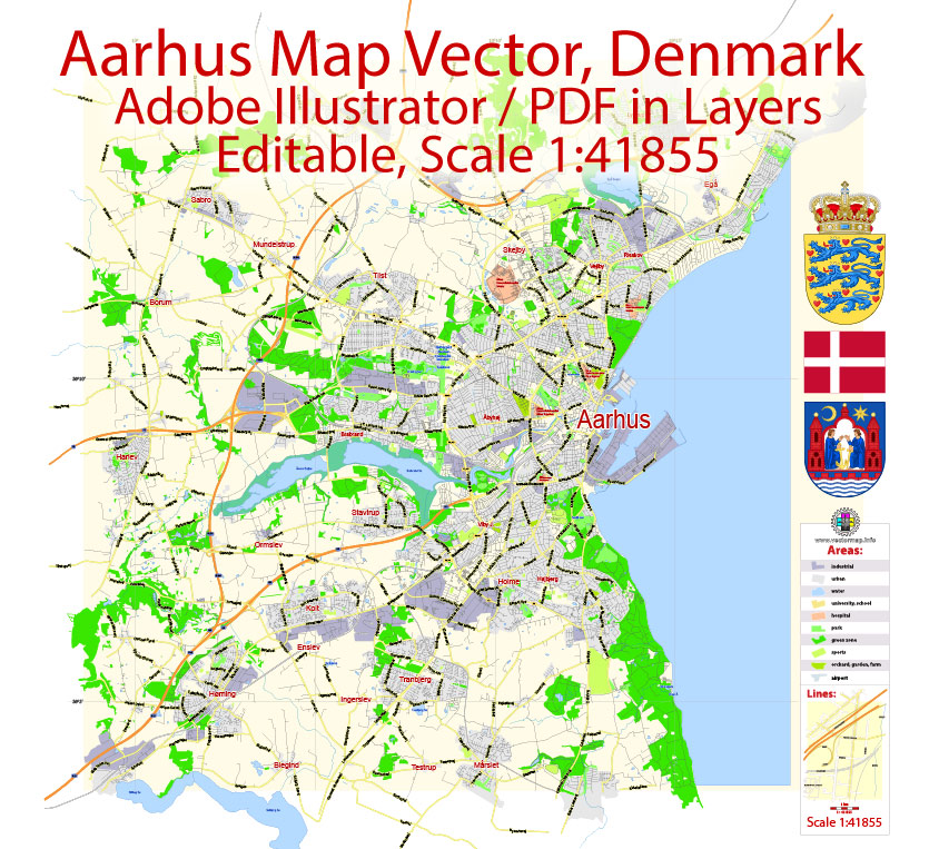
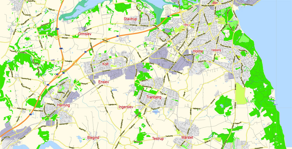
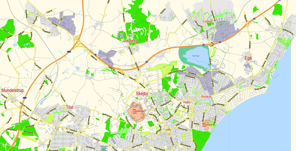
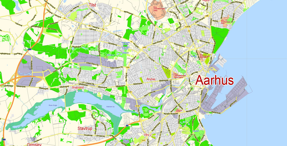
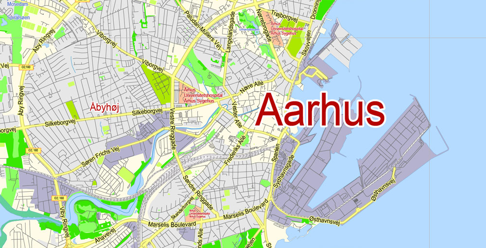
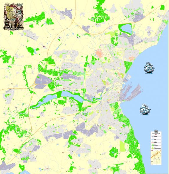
Printable Vector Map Aarhus Denmark exact City Plan scale 1:41855 editable Adobe Illustrator Street Map in layers 3 Mb ZIP.
Principal streets names, main objects. Map for publishing, design, printing, publications, arts, projects, presentations, for architects, designers and builders, business, logistics. The most exact and detailed map of the city in scale
Layers: legend, grids, labels_roads, names_places, names_streets, names_objects, streets_roads, color_fills, etc.
Text format all names
For High Quality Printing
DWG, DXF, CDR, ESRI Shapes, and other formats – by request, same price, please contact.
Aarhus, Denmark.
This vector map of Aarhus city is used as a basis for design, editing, and further printing.
This is the most detailed, exact map of Aarhus city for high-quality printing and polygraphy. You can always clarify the map development date by contacting us.
For your convenience, all objects on Aarhus vector city map are divided into layers. And the editing is very easy – colors, lines, etc.
You can easily add any objects needed (e.g. shops, salons, sale points, gas station or attraction) on any layer of Aarhus vector map.
One of the advantages of Aarhus city vector maps of our production is the relevance of cartographic data, we constantly update all our products.
Aarhus is the second-largest city in Denmark and the seat of Aarhus municipality. It is located on the east coast of the Jutland peninsula, in the geographical centre of Denmark, 187 kilometres (116 mi) northwest of Copenhagen and 289 kilometres (180 mi) north of Hamburg, Germany. The inner urban area contains 273,077 inhabitants (as of 1 January 2018) and the municipal population is 340,421 (as of 2018). Aarhus is the central city in the East Jutland metropolitan area, which had a total population of 1.378 million in 2016.
This vector map of Aarhus city is used by:
designers, layout designers, printers, advertisers and architects. Our product – vector maps – is designed for further editing and printing in large formats – from @Wall format (a few meters) to A-0 and A-1, A-2, A-3.
The Aarhus city map in vector format is used for design, urban planning, presentations and media visualizations.
The advertising and presentation map of Aarhus city (usually the final designer marks the routes, and puts the client’s objects (shops, saloons, gas stations etc.)
The undoubted advantage is that people will NEVER throw out this advertising product – the map. In fact, as an advertising medium, a city map is the most “long-playing” of the well-known polygraphic advertising media, with the longest lifespan, and the maximum number of interactions with the customer.
For travelers, maps are sold at the airports and gas stations around the world. Often the source is our vector maps.
The history of Aarhus began as a fortified Viking settlement founded in the 8th century and with the first written records stemming from the bishopric seated here from at least 948. The city was founded on the northern shores of a fjord at a natural harbour and the primary driver of growth was for centuries seaborne trade in agricultural products.
Take a look, who purchases our vector maps of Aarhus city in “Our Clients and Friends” page – these are large and small companies, from super-brands like Volvo and Starbucks, to small design studios and printing houses.
It’s very easy to work with vector maps of Aarhus city, even for a not very experienced designer who can turn on and off the map layers, add new objects, change the colors of fill and lines according to customer requirements.
The undoubted advantage of Aarhus city vector maps in printing is an excellent and detailed visualization, when customer can expand a large paper map and instantly define his location, find a landmark, an object or address on map, unlike using the popular electronic formats of Google and Yandex maps for example.
Market town privileges were granted in 1441, but growth stagnated in the 17th century as the city suffered blockades and bombardments during the Swedish Wars. In the 19th century it was occupied twice by German troops during the Schleswig Wars but avoided destruction. As the industrial revolution took hold, the city grew to become the second-largest in the country by the 20th century.
Printable vector maps of Aarhus city are much more convenient and efficient than any electronic maps on your smartphone, because ALL DETAILS are displayed in the entire space of Aarhus city map.
Useful tips on working with vector maps of cities and countries in Adobe Illustrator.
«V» – launches the Selection tool (cursor, black arrow), which makes active any vector line.
«А» – launches the Direct Selection tool (white cursor), allows you to select curve elements and drag them to the desired place.
«R» – activates the Rotate tool, which helps you rotating selected objects around the center point by 360 degrees.
«E» – gives you the opportunity to use the Eraser tool and erase unnecessary parts.
«X» – switches between Fill and Stroke in the Tools section. Try to get used to this hot key and
you will quickly understand that you can’t live and work without it.
Guides are not limited to vertical and horizontal in Adobe Illustrator. You can also create a diagonal guide for example. Moreover, you can turn any contours into guides. Select the outline and go to View > Guides > Make Guides (Create Guides), or simply press Cmd/Ctrl + 5. You can also turn the guides back into an editable object. Go to menu, View > Guides > Unlock Guides (Release Guides), select the guide you want to edit and select View > Guides > Release Guides (Reset Guides), or just press Cmd/Ctrl + Option / Alt + 5).
Today, Aarhus is at the cultural and economic core of the region and the largest centre for trade, services and industry in Jutland. The city ranks as the 92nd largest city in the European Union, and as number 234 among world cities. It is also a top 100 conference city in the world. Aarhus is the principal industrial port of the country in terms of container handling and an important trade hub in Kattegat. Major Danish companies have based their headquarters here and people commute for work and leisure from a wide area in Region Midtjylland. It is a centre for research and education in the Nordic countries and home to Aarhus University, Scandinavia’s largest university, including Aarhus University Hospital and INCUBA Science Park. Being the Danish city with the youngest demographics, with 48,482 inhabitants aged under 18, Aarhus is also the second fastest growing Danish city, with an average growth of 4,500 people per annum since 2008.
You will probably want to change the color scheme used on our Aarhus vector city map.
To quickly and effectively play with colors.
Of course, you can do it manually, all objects in our Aarhus city vector map are divided according to types and layers, and you can easily change the color gamma of vector objects in groups and layers.
But there is more effective way of working with the whole VECTOR MAP of Aarhus city and all layers:
The overview dialog «Edit colors»/«Repaint Graphic Object» (this dialog box name can change depending on the context):
If you have selected a part or a layer of Aarhus city vector map and open the dialog box by clicking the icon in the Control panel, on the Samples palette or the Color Catalog, or if you choose Edit > Edit Colors> Repaint Graphic Object, then the «Repaint Graphic Object» dialog box appears, and you get access to «Assign» and «Edit» tabs.
If a picture or a map fragment is not selected, and you open the dialog box by clicking the icon in the Control panel, on the Samples palette or in the Color Catalog, the «Edit Colors» dialog box appears and you can only access the «Edit» tab.
Regardless of the name at the top of the dialog box, the right-hand side always displays the color group of the current document, as well as two default color groups: Print Color and Grayscale. These color groups can be selected and used any time.
Create and edit color groups of Aarhus city vector map, and also assign colors using the «Edit Colors»/ а «Repaint Graphic Object» dialog box.
A. Creating and editing of a color group on the «Edit» tab
B. Assigning colors on the «Assign» tab
C. Select a group of colors from the «Color groups» list
The option «Repaint a graphic object» in the lower part of the dialog box allows you to preview the colors on a selected layer of Vector map, or a group of elements, and specify whether its colors will be redefined when the dialog box is closed.
The main areas of the dialog box are:
«Edit»
The «Edit» tab is designed to create a new or edit the existing color groups.
The harmony rules Menu and the Color Wheel are used to conduct experiments with color harmonies. The color wheel shows how colors are related in color harmony, and the color bars allow you to view and manipulate an individual color values. In addition, you can adjust the brightness, add and remove colors, save color groups and view colors on the selected Vector Map of Aarhus city or a separated layers.
Aarhus is known for its musical history. In the 1950s, many jazz clubs sprang up around the city, fuelled by the young population. By the 1960s, the music scene diversified into rock and other genres. In the 1970s and 1980s, Aarhus became the centre for Denmark’s rock music, fostering many iconic bands such as TV-2 and Gnags. Aarhus is home to the annual eight-day Aarhus International Jazz Festival, the SPoT Festival, and the NorthSide Festival.
«Assign»
The «Assign» tab is used to view and control on how the original colors are replaced with colors from the color group like your corporate colors in the Vector Map of Aarhus city.
The assign color ability is provided only if the entire map, layer or fragment is selected in the document. You can specify which of new colors replace the current colors, whether the spot colors should be preserved and how colors are replaced (for example, you can replace colors completely or changing the color tone while maintaining the brightness). The «Assign» tab allows you to redefine colors in the Vector Map of Aarhus city, or in separate layers and fragments using the current color group or reducing the number of colors in the current Vector Map.
Color groups
Is a list of all saved color groups for current document (the same groups appear in the «Samples» palette). You can edit and delete the existing color groups, as well as creating a new ones using the list of “Color Groups” in the dialog box. All changes appear in the «Samples» palette.
The highlighted color group shows, which color group is currently edited.
Any color group can be selected and edited, or used to redefine the colors in the selected vector map of Aarhus city, its fragments or elements.
Saving a color group adds this group to the specified list.
Opening the «Edit Colors»/«Repaint Graphic Object» dialog box.
Open the «Edit Colors»/«Repaint Graphic Object» dialog box using one of the following methods:
«Edit»> «Edit Colors»> «Repaint Graphic object» or «Repaint With Style».
Geography
Aarhus is located at the Bay of Aarhus facing the Kattegat sea in the east with the peninsulas of Mols and Helgenæs across the bay to the northeast. Mols and Helgenæs are both part of the larger regional peninsula of Djursland. A number of larger cities and towns is within easy reach from Aarhus by road and rail, including Randers (38.5 kilometres (23.9 mi) by road north), Grenå (northeast), Horsens (50 kilometres (31 mi) south) and Silkeborg (44 kilometres (27 mi) east).
Use these commands if you need to edit the colors in the selected vector map of Aarhus city.
«Repaint Graphic object» button on the «Control» panel.
Use this button if you need to adjust colors of Aarhus city vector map using the а «Repaint graphic object» dialog box.
The specified button is available if the selected vector map or its fragment contains two or more colors.
Note. This color editing method is convenient for global color adjustment in a vector map, if global colors were not used when creating a City Map of Aarhus.
The «Edit colors» button or «Edit or apply colors» on the «Color Catalog» palette
Click this button if you need to edit colors on the «Color Catalog» palette or edit and then apply them to the selected Vector Map of Aarhus city or its fragment.
The «Edit color group» button or «Edit or apply color group» on the «Samples» palette.
Click this button if you need to edit the colors in the specific color group or edit and apply them to the selected Vector Map of Aarhus city or a group of its elements, for example, the whole layer “Streets and lines”. You can also double-click the color group in the Samples panel to open the dialog box.
If the map file is too large and your computer freezes or even can’t open it quickly:
1. Try to reduce the color resolution of the video card (display) to 256 colors while working with a large map.
2. Using Windows Task Manager, select all the application you don’t need, while working with map, just turn them off.
3. Launch Adobe Illustrator. (DO NOT OPEN the vector map file)
4. Start the Windows Task Manager using administrator rights > Find the “Illustrator” process > set the «real time» priority,
5. Open the file. When you see the LEGACY FONT popup window – click “OK” (do not update). You can restore the TEXT later.
6. Can also be useful: When file is opened – Edit > Settings > Basic Settings > disable smoothing. /// It looks scary, but works quickly)))
We recommend saving the file in Adobe Illustrator 10 version. It’s much more stable when working with VERY BIG size files.
Topography
At Aarhus’s location, the Bay of Aarhus provides a natural harbour with a depth of 10 m (33 ft) quite close to the shore. Aarhus was founded at the mouth of a brackish water fjord, but the original fjord no longer exists, as it has gradually narrowed into what is now the Aarhus River and the Brabrand Lake, due to natural sedimentation. The land around Aarhus was once covered by forests, remains of which exist in parts of Marselisborg Forest to the south and Riis Skov to the north. Several lakes extend west from the inner city as the landscape merges with the larger region of Søhøjlandet with heights exceeding 152 metres (499 ft) at Himmelbjerget between Skanderborg and Silkeborg. The highest natural point in Aarhus Municipality is Jelshøj at 128 metres above sea level, in the southern district of Højbjerg. The hilltop is home to a Bronze Age barrow shrouded in local myths and legends.
The hilly area around Aarhus consists of a moranial plateau from the last ice age, broken by a complex system of tunnel valleys. The most prominent valleys of this network are the Aarhus Valley in the south, stretching inland east-west with the Aarhus River, Brabrand Lake, Årslev Lake and Tåstrup Lake, and the Egå Valley to the north, with the stream of Egåen, Egå Engsø, the bog of Geding-Kasted Mose and Geding Lake. Most parts of the two valleys have been drained and subsequently farmed, but in the early 2000s some of the drainage was removed and parts of the wetlands were restored for environmental reasons. The valley system also includes the stream of Lyngbygård Å in the west and valleys to the south of the city, following erosion channels from the pre-quaternary. By contrast, the Aarhus River Valley and the Giber River Valley are late glacial meltwater valleys. The coastal cliffs along the Bay of Aarhus consist of shallow tertiary clay from the Eocene and Oligocene (57 to 24 million years ago).
Landmarks
Aarhus Cathedral (Århus Domkirke) in the centre of Aarhus, is the longest and tallest church in Denmark at 93 m (305 ft) and 96 m (315 ft) in length and height respectively. Originally built as a Romanesque basilica in the 13th century, it was rebuilt and enlarged as a Gothic cathedral in the late 15th and early 16th centuries. Even though the cathedral stood finished around 1300, it took more than a century to build; the associated cathedral school of Aarhus Katedralskole was already founded in 1195 and ranks as the 44th oldest school in the world. Another important and historic church in the inner city, is the Church of our Lady (Vor Frue Kirke) also from the 13th century in Romanesque and Gothic style. It is smaller and less impressive, but it was the first cathedral of Aarhus and founded on an even older church constructed in 1060; the oldest stone church in Scandinavia. Parts of this former church were excavated in the 1950s and can now be experienced as a crypt beneath the nave of Vor Frue Kirke. Langelandsgade Kaserne in National Romantic Style from 1889 is the oldest former military barracks left in the country; home to the university Department of Aesthetics and Communication since 1989. Marselisborg Palace (Marselisborg Slot), designed by Hack Kampmann in Neoclassical and Art Nouveau styles, was donated by the city to Prince Christian and Princess Alexandrine as a wedding present in 1898. The Aarhus Custom House (Toldkammeret) from 1898, is said to be Hack Kampmann’s finest work.
Tivoli Friheden (Tivoli Freedom) opened in 1903 and has since been the largest amusement park in the city and a tourist attraction. Aarhus Theatre from 1916 in the Art Nouveau style is the largest provincial theatre in Denmark. The early buildings of Aarhus University, especially the main building completed in 1932, designed by Kay Fisker, Povl Stegmann and by C.F. Møller have gained an international reputation for their contribution to functionalist architecture. The City Hall (Aarhus Rådhus) from 1941 with an iconic 60 m (200 ft) tower clad in marble, was designed by Arne Jacobsen and Erik Møller in a modern Functionalist style.
Aarhus
City in Denmark
Aarhus is a city in Denmark on the Jutland peninsula’s east coast. Den Gamle By is its old town open-air museum, with centuries-old timbered houses. Nearby are the greenhouses of the Aarhus Botanical Garden. In the center, the multistory ARoS art museum shows global contemporary works. The underground Viking Museum explores early local history. Nearby, Aarhus Cathedral has restored 14th- to 16th-century frescoes.
Area
• Urban 91 km2 (35 sq mi)
• Municipal 468 km2 (181 sq mi)
Highest elevation 105 m (344 ft)
Lowest elevation 0 m (0 ft)
Population
• Rank Denmark: 2nd
• Urban 273,077
• Urban density 2,854/km2 (7,390/sq mi)
• Municipal 340,421
• Municipal density 707/km2 (1,830/sq mi)
See Also: Full Detailed Printable Vector Map Aarhus
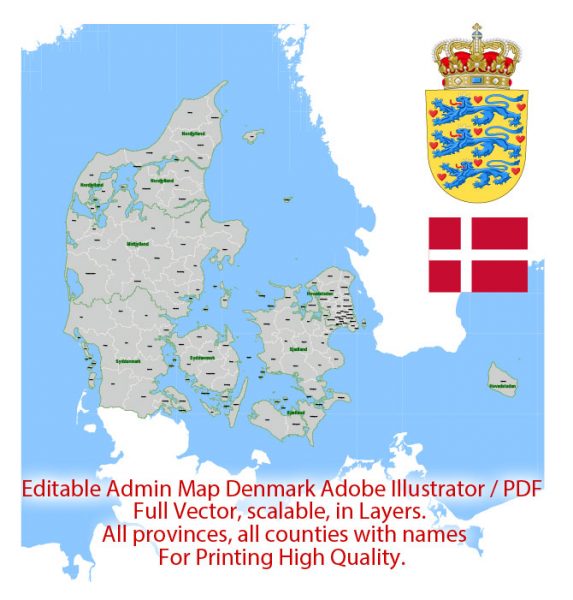
See Also: Admin Map Denmark
Free vector maps:

Free download printable map Europe vector Adobe Illustrator >>>
Free download printable PDF map Europe vector Adobe PDF >>>

 Author: Kirill Shrayber, Ph.D. FRGS
 street City Plan map, full editable, Adobe Illustrator")
