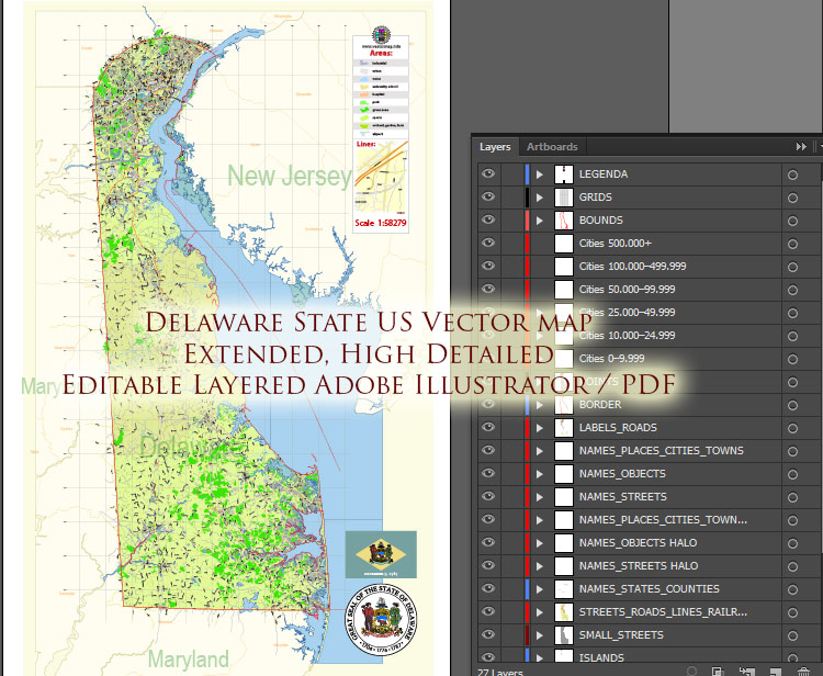
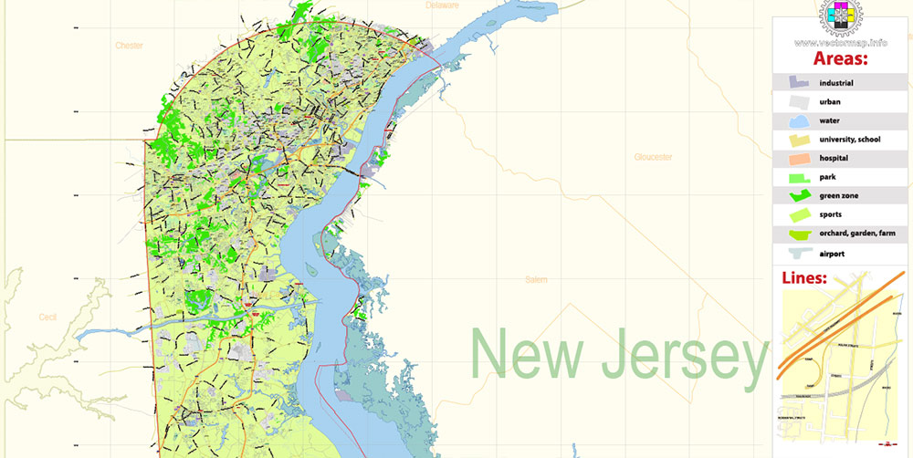
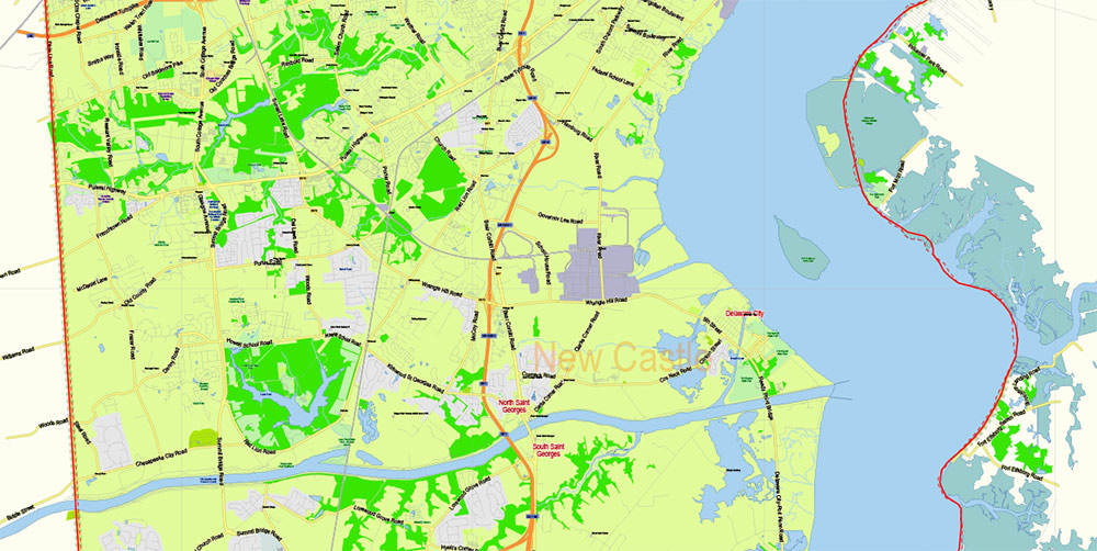
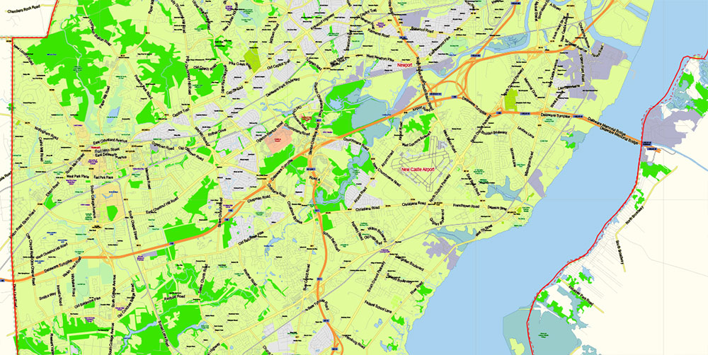
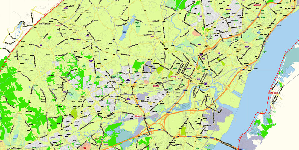
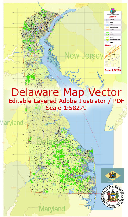
Extended Description of the Vector Map
Printable PDF Vector Map of Delaware State US extended (cities names by population categories by layers) detailed Plan scale 1:58279 full editable Adobe PDF Road Admin Map in layers, scalable, text format all names, 65 MB ZIP
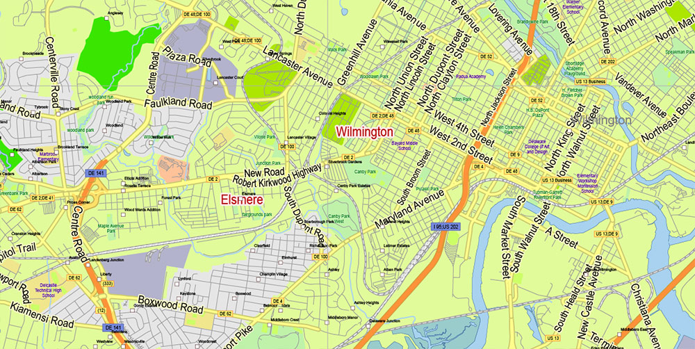
Principal street names, All Cities and Towns, Main Objects, Counties. Map for design, printing, arts, projects, presentations, for architects, designers, and builders, business, logistics.
If you need: we can add postal codes (zip codes areas with numbers) to the map as a separated layer.
The most exact and detailed map of the state in scale.
For Editing and High-Quality Printing
Layers list Maryland State Roads Admin map:
- Legend
- Grids
- Labels of roads
- Addon layers – Cities by population categories + addon points
- Points of airports
- Names of airports
- Names of places (city, hamlet, etc.)
- Names of cities, towns, hamlets 2
- Names of objects (hospitals, schools, parks, water)
- Points of cities, towns, hamlets
- Names of Main streets
- Main Streets, roads.
- Civil streets
- Railroads
- Waterways (lines)
- Water objects (rivers, lakes, ponds) areas
- Names of Counties
- Names of States
- Counties areas
- States areas
- Color fills (parks, hospital areas, school areas, etc.)
- Background and sea
_Delaware State US PDF Map Vector Extended Exact detailed Road Admin Map editable Adobe PDF in layers
1. AO OVERVIEW
-
Smallest effective battlefield in the Mid-Atlantic: thin north–south strip between Pennsylvania, Maryland, and New Jersey.
-
Operational character: flat terrain, soft soils, dense river/bay coastline.
-
Strategic value: controls the Delaware Bay approach toward Philadelphia and the Northeast industrial belt.
-
Division:
-
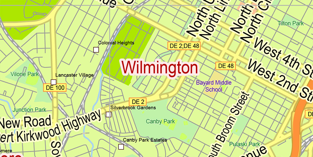
Northern Urban Zone (Wilmington–New Castle).
-
Central Agricultural Belt (Middletown–Smyrna–Dover).
-
Southern Rural/Coastal Zone (Sussex County: Georgetown–Lewes–Rehoboth).
2. KEY TERRAIN & REGIONS
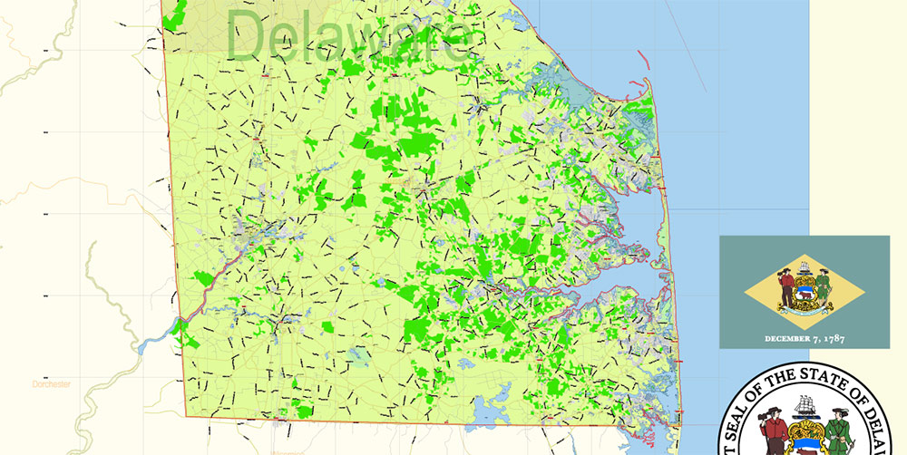
Northern Region (New Castle County)
-
Urban–suburban density; rolling low hills.
-
Financial and corporate activity hubs; industrial facilities.
-
Key chokepoints along I-95, I-495, and I-295.
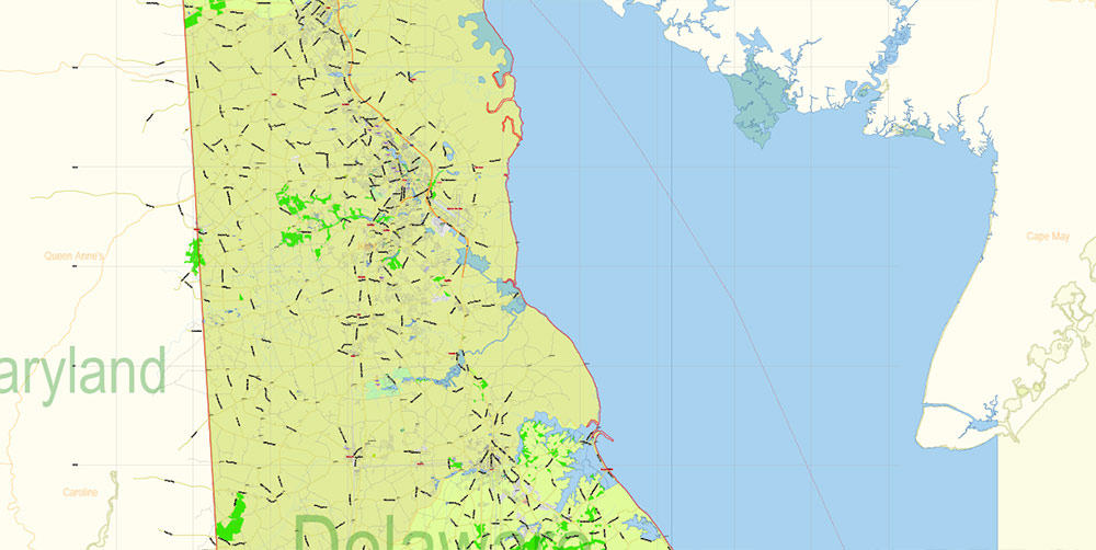
Central Region (Kent County)
-
Broad flatlands, open fields, few forests.
-
State capital Dover; multiple military and government assets.
-
Good helicopter LZ potential; limited vertical obstacles.
Southern Region (Sussex County)
-
Rural, agricultural, and coastal tourism areas.
-
Marshes, deltas, and tidal flats near the Atlantic beaches and Delaware Bay.
-
Poor cross-country mobility due to soft wet ground.
3. LINES OF COMMUNICATION (ROUTES)
Primary MSRs
-
I-95:
-
US-13:
-
US-1 (Toll segment):
-
DE-1 Coastal Highway:
Key ASRs
-
US-113, DE-9, DE-24, DE-26, DE-54:
4. URBAN AREAS & HUMAN TERRAIN
Major Cities
Demographic Profile
-
Total population ~1 million.
-
North: dense, diversified, corporate-professional.
-
Central: government workers, suburban families, agricultural communities.
-
South: rural, small towns, seasonal influx of tourists.
-
Socioeconomic gradient: wealthier near Wilmington; more modest rural counties.
5. HYDROGRAPHY & WATER RESOURCES
-
Delaware River & Bay:
-
Forms entire eastern boundary.
-
Deepwater channels used by ships heading to Philadelphia port complex.
-
Marshlands and tidal flats = poor ground support for vehicles.
-
Inland Waterways:
-
Christina River: cuts through Wilmington; industrial banks, port facilities.
-
St. Jones River, Mispillion River, Nanticoke River: shallow, meandering, heavy marsh zones.
-
Numerous ponds and coastal lakes in Sussex County.
-
Hydrologic Implications:
-
Soft soils, frequent flooding in flat lowlands.
-
Many bridges on minor roads; damage to even a few can isolate entire sectors.
-
Amphibious mobility is advantageous; tracked heavy vehicles may bog down.
6. TRANSPORT & INFRASTRUCTURE
-
Air:
-
Dover Air Force Base: strategic airlift hub (C-5, C-17 operations). Dominant military node in the AO.
-
Wilmington Airport: regional aviation and cargo.
-
Multiple small airfields in Sussex for GA and medevac.
-
Sea/River:
-
Rail:
-
Amtrak Northeast Corridor crosses Wilmington; tunnels and bridges are critical infrastructure.
-
Freight corridors (CSX, Norfolk Southern) run parallel to the river and major highways.
-
Energy/Comms:
7. CLIMATE & WEATHER
-
Humid coastal: mild winters, warm summers, frequent humidity.
-
Storm risk:
-
Atlantic cyclones, nor’easters, and coastal surges.
-
Roads along the bay and beaches vulnerable to washouts.
-
Winter: occasional snow/ice; more severe inland than along the shore.
-
Fog: regular along rivers and marshlands – air ops visibility reduced.
8. KEY INSTALLATIONS & STRATEGIC NODES
-
Dover AFB: number one military objective in the state; high logistics throughput.
-
Wilmington Industrial Corridor: chemical plants, refineries, port terminals, corporate HQ presence.
-
I-95 Corridor: essential for controlling access to the Northeast.
-
Bay and River Bridges: limited in number; loss of even one can cause massive detouring.
-
Beach Corridor: tourism-heavy but tactically weak ground; evacuation bottlenecks.
9. HAZARDS & LIMITATIONS
10. COMMAND TAKEAWAYS
-
Northern Delaware is the strategic heart: I-95, Wilmington port, corporate and financial nodes.
-
Dover AFB is the decisive military asset: control or deny it to dominate air logistics in the region.
-
Expect poor ground mobility in Sussex and Kent: marshes, tides, and soft soils demand lighter or amphibious units.
-
Bridge control = operational success: especially river crossings and DE-1 coastal bridges.
-
Civil environment highly sensitive: small state = rapid spread of information, heavy media/judicial presence.
-
Weather exposure: storms dictate tempo along the coast; maintain alternate inland routes.
_Delaware State US PDF Map Vector Extended Exact detailed Road Admin Map editable Adobe PDF in layers
_Delaware State US PDF Map Vector Extended Exact detailed Road Admin Map editable Adobe PDF in layers
_Delaware State US PDF Map Vector Extended Exact detailed Road Admin Map editable Adobe PDF in layers
_Delaware State US PDF Map Vector Extended Exact detailed Road Admin Map editable Adobe PDF in layers
_Delaware State US PDF Map Vector Extended Exact detailed Road Admin Map editable Adobe PDF in layers
_Delaware State US PDF Map Vector Extended Exact detailed Road Admin Map editable Adobe PDF in layers
_Delaware State US PDF Map Vector Extended Exact detailed Road Admin Map editable Adobe PDF in layers
_Delaware State US PDF Map Vector Extended Exact detailed Road Admin Map editable Adobe PDF in layers
Author Rating
Aggregate Rating
no rating based on 0 votes
@vectormapper
Product Name Delaware State Map Vector Exact Plan detailed Road Admin Map editable Adobe Illustrator in layers
Price
USD 39
Product Availability
Available in Stock


 Author: Kirill Shrayber, Ph.D. FRGS

