Editable Vector Map of the Reno Nevada US in SVG format.
Can be edited in the following programs: Adobe Illustrator, CorelDraw, InkScape
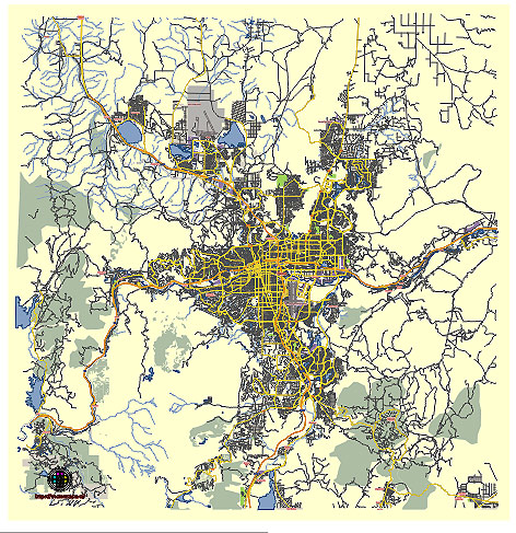
Principal streets and roads, names places, residential streets and roads, road number labels, water objects, land use areas.
Reno Nevada US vector map svg free
DOWNLOAD ARCHIVE FOR FREE >>>
Distributed with Creative Commons CC-Zero = Creative Commons CC0 1.0 Universal Public Domain Dedication International License
SEE ALSO FULL VERSION OF THE Reno Nevada US vector map (Adobe Illustrator, PDF etc.)
Principal Streets and Roads in Reno, Nevada
- Virginia Street: One of the most prominent streets in Reno, Virginia Street runs through the heart of downtown and is home to many of the city’s casinos, hotels, and the famous Reno Arch.
- McCarran Boulevard: A major loop road around Reno, McCarran Boulevard connects various neighborhoods and commercial areas, providing access to different parts of the city.
- South Virginia Street: Extending south from downtown, South Virginia Street is a key commercial corridor with shopping centers, restaurants, and other businesses.
- Kietzke Lane: Another important street for commerce, Kietzke Lane runs parallel to South Virginia Street and features numerous car dealerships, retail stores, and dining options.
- Mill Street: This east-west road provides access to the Reno-Tahoe International Airport and connects to downtown Reno.
- Fourth Street/Prater Way: Running parallel to Interstate 80, Fourth Street (which becomes Prater Way) is part of the historic Lincoln Highway and offers a mix of industrial, commercial, and residential areas.
- Plumb Lane: An essential east-west route in Reno, Plumb Lane connects residential neighborhoods with commercial areas, including the Reno-Tahoe International Airport.
- Moana Lane: Another major east-west thoroughfare, Moana Lane features various retail establishments and provides access to residential neighborhoods.
- California Avenue: A key street in southwest Reno, California Avenue is known for its boutique shops, restaurants, and historic homes.
- West Fourth Street: Leading west from downtown, West Fourth Street is a gateway to the Truckee River and various recreational areas.
Principal City Districts in Reno, Nevada
- Downtown Reno: The bustling heart of the city, downtown Reno is known for its casinos, the iconic Reno Arch, the Truckee River Walk, and cultural attractions like the Nevada Museum of Art.
- Midtown Reno: A vibrant district south of downtown, Midtown is known for its eclectic mix of shops, restaurants, bars, and art galleries. It has undergone significant revitalization in recent years.
- Old Southwest: This historic district features tree-lined streets, older homes, and a mix of residential and commercial areas. It is one of Reno’s most charming neighborhoods.
- Northeast Reno: A diverse residential area with a mix of housing options, schools, and parks. It is also home to the University of Nevada, Reno.
- Northwest Reno: A primarily residential area that offers suburban living with views of the Sierra Nevada. It includes various schools, parks, and shopping centers.
- South Reno: This rapidly growing area includes newer residential developments, large shopping centers like The Summit, and recreational areas such as the Virginia Foothills Park.
- Somersett: A planned community in northwest Reno featuring golf courses, parks, and walking trails. It is known for its scenic views and upscale homes.
- Damonte Ranch: Located in South Reno, Damonte Ranch is a master-planned community with residential neighborhoods, schools, and parks.
- Double Diamond: Another planned community in South Reno, Double Diamond offers modern housing, commercial centers, and access to major highways.
- Sparks: While technically a separate city, Sparks is often considered part of the greater Reno metropolitan area. It features Victorian Square, Legends Outlet Mall, and the Sparks Marina Park.
These streets and districts collectively shape the character and daily life of Reno, providing residents and visitors with a wide range of experiences and amenities.
 Author: Kirill Shrayber, Ph.D. FRGS