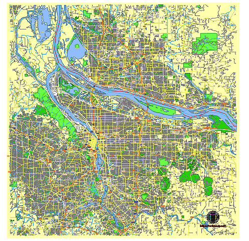
Editable Vector Map of the Portland Oregon Vancouver Washington US in SVG format.
Can be edited in the following programs: Adobe Illustrator, CorelDraw, InkScape
Principal streets and roads, names places, residential streets and roads, road number labels, water objects, land use areas.

Portland Oregon Vancouver Washington US vector map svg free
DOWNLOAD ARCHIVE FOR FREE >>>
Distributed with Creative Commons CC-Zero = Creative Commons CC0 1.0 Universal Public Domain Dedication International License
Portland, Oregon is known for its diverse neighborhoods, vibrant culture, and distinct districts. Here is an overview of some of the principal streets, roads, and city districts:
Principal Streets and Roads
- Burnside Street:
- A major east-west thoroughfare that divides Portland into North and South.
- Home to the iconic Burnside Bridge and various nightlife spots.
- Naito Parkway:
- Runs along the west bank of the Willamette River.
- Provides access to Waterfront Park and downtown attractions.
- Martin Luther King Jr. Boulevard (MLK):
- A significant north-south route in Northeast Portland.
- Known for its diverse range of shops, restaurants, and businesses.
- Division Street:
- Runs east-west and is famous for its trendy restaurants, bars, and boutiques.
- A key destination in the Southeast district.
- Hawthorne Boulevard:
- Another major east-west street in Southeast Portland.
- Known for its eclectic mix of vintage shops, cafes, and music venues.
- Powell Boulevard:
- A major east-west arterial road connecting downtown Portland with the outer southeast neighborhoods.
- Sandy Boulevard:
- Diagonally cuts through Northeast Portland.
- Known for its quirky businesses and vibrant nightlife.
Key Districts
- Downtown:
- The central business district.
- Hosts Pioneer Courthouse Square, numerous corporate headquarters, and the Portland Art Museum.
- Pearl District:
- Formerly an industrial area, now a chic neighborhood with art galleries, upscale shops, and dining.
- Known for its converted warehouses and loft-style living spaces.
- Northwest District:
- Includes Nob Hill and the Alphabet District.
- Characterized by historic Victorian homes, boutique shopping, and popular 23rd Avenue.
- Lloyd District:
- An economic and commercial hub in Northeast Portland.
- Home to the Oregon Convention Center, Moda Center, and Lloyd Center Mall.
- Alberta Arts District:
- A vibrant neighborhood in Northeast Portland known for its art galleries, street art, and Last Thursday Art Walk.
- Mississippi/Williams:
- An area in North Portland known for its hip, lively atmosphere.
- Features a mix of vintage shops, food carts, and trendy eateries.
- Hawthorne District:
- Located in Southeast Portland along Hawthorne Boulevard.
- Famous for its bohemian vibe, unique shops, and diverse culinary scene.
- Sellwood-Moreland:
- A family-friendly neighborhood in Southeast Portland.
- Offers antique shops, parks, and the historic Oaks Amusement Park.
- St. Johns:
- A historic district in North Portland with a small-town feel.
- Notable for the St. Johns Bridge and a variety of local shops and eateries.
- South Waterfront:
- A rapidly developing area along the Willamette River.
- Known for its modern high-rises, OHSU facilities, and scenic riverfront views.
These streets and districts each contribute to the unique character and charm of Portland, making it a diverse and interesting city to explore.
Vancouver, Washington, has a diverse range of principal streets, roads, and city districts, each contributing to the city’s infrastructure and community dynamics.
Principal Streets and Roads
- Main Street: Running through the heart of downtown, Main Street is a focal point for businesses and cultural activities.
- Fourth Plain Boulevard: A major east-west corridor that connects various neighborhoods and commercial areas.
- Mill Plain Boulevard: Another key east-west route, heavily used for commuting and lined with commercial establishments.
- Andresen Road: A significant north-south route that intersects with several key east-west roads, providing access to residential and commercial areas.
- Highway 99: Runs parallel to Interstate 5, serving as a major arterial route for local traffic and businesses.
- SE 164th Avenue: A major north-south road in the eastern part of the city, crucial for accessing suburban residential areas.
- NE 137th Avenue: Important for connecting neighborhoods and facilitating access to local amenities and schools
- Downtown Vancouver: The central business district with a mix of historic and modern buildings, home to government offices, retail, and dining.
- Uptown Village: A vibrant neighborhood known for its eclectic mix of shops, cafes, and community events.
- Columbia Way: Located along the waterfront, featuring parks, trails, and scenic views of the Columbia River.
- Cascade Park: A residential area in the eastern part of the city, known for its suburban feel and family-friendly amenities.
- Hazel Dell: A large suburban district to the north of downtown, with a variety of shopping centers, schools, and parks.
- Fishers Landing: A growing neighborhood in the southeast, characterized by newer residential developments and commercial hubs.
- Orchards: A suburban district to the northeast, with a mix of residential and commercial properties
These streets and districts form the backbone of Vancouver, WA, each contributing to the city’s functionality and livability.

 Author: Kirill Shrayber, Ph.D. FRGS