Editable Vector Map of the Calgary Alberta Canada in SVG format.
Can be edited in the following programs: Adobe Illustrator, CorelDraw, InkScape
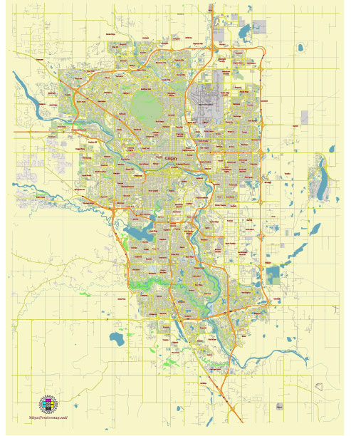
Principal streets and roads, names places, residential streets and roads, road number labels, water objects, land use areas.
Calgary Alberta Canada editable vector map svg free
DOWNLOAD ARCHIVE FOR FREE >>>
Distributed with Creative Commons Attribution 4.0 International License
SEE ALSO FULL VERSION OF THE Calgary Alberta Canada vector map (Adobe Illustrator, PDF etc.)
Calgary, Alberta, is a dynamic city with a variety of streets, roads, and districts that give it its unique character. Here’s an overview of some of the principal streets, roads, and city districts in Calgary:
Principal Streets and Roads
- 16 Avenue NW (Trans-Canada Highway)
- This is a major east-west route through Calgary, part of the Trans-Canada Highway system. It connects many communities and commercial areas.
- Macleod Trail
- A significant north-south route that runs from the downtown core south through numerous residential and commercial districts.
- Crowchild Trail
- An important arterial road that runs in a northwest-southeast direction, providing access to many key areas, including the University of Calgary.
- Deerfoot Trail (Highway 2)
- The primary north-south freeway in Calgary, which is a crucial route for commuting and connects the northern and southern edges of the city.
- Glenmore Trail
- A major east-west expressway that provides a key connection across the southern part of Calgary.
- Memorial Drive
- Runs parallel to the Bow River and provides scenic views of downtown Calgary and access to various parks and landmarks.
- 17 Avenue SW (Red Mile)
- Known for its vibrant nightlife, dining, and shopping, especially in the Beltline and Mount Royal areas.
Major City Districts
- Downtown Calgary
- The central business district with a mix of office towers, retail spaces, and cultural venues. Key areas include the Downtown West End, East Village, and the Downtown Commercial Core.
- Beltline
- Just south of downtown, this area is known for its high-density residential buildings, trendy shops, and restaurants. Notable sub-areas include Victoria Park and Connaught.
- Inglewood
- One of Calgary’s oldest neighborhoods, known for its historic buildings, unique shops, and vibrant arts scene.
- Kensington
- A popular district northwest of downtown, known for its pedestrian-friendly streets, boutiques, cafes, and cultural events.
- Mission
- A lively area with a mix of residential and commercial spaces, famous for the 4th Street Lilac Festival and a variety of dining options.
- Bridgeland
- Located northeast of downtown, Bridgeland is known for its Italian heritage, dining, and views of the Calgary skyline.
- Chinatown
- Situated along the Bow River, this district is a hub for Chinese culture, cuisine, and businesses.
- East Village
- A revitalized area on the eastern edge of downtown, featuring modern residential buildings, the National Music Centre, and RiverWalk.
- Mount Royal
- A prestigious residential neighborhood with historic homes and tree-lined streets.
- Stephen Avenue
- A major pedestrian mall in the heart of downtown Calgary, known for its historic buildings, shopping, dining, and entertainment venues.
Key Points of Interest
- Calgary Tower
- A prominent landmark offering panoramic views of the city.
- Stampede Park
- Home to the annual Calgary Stampede, one of the largest rodeos in the world.
- Prince’s Island Park
- An urban park on an island in the Bow River, hosting festivals and outdoor activities.
- The Core Shopping Centre
- A major retail complex in downtown Calgary.
These streets, roads, and districts contribute to Calgary’s diverse and vibrant urban landscape, making it a dynamic place to live, work, and visit.
 Author: Kirill Shrayber, Ph.D. FRGS