Washington and Baltimore vector maps, Atlas 100 parts. USA
Archive size: 299 Mb, zipped .AI
DPI: 300
This vector maps of Washington and Baltimore is created using 2015 data.
License: Royalty Free
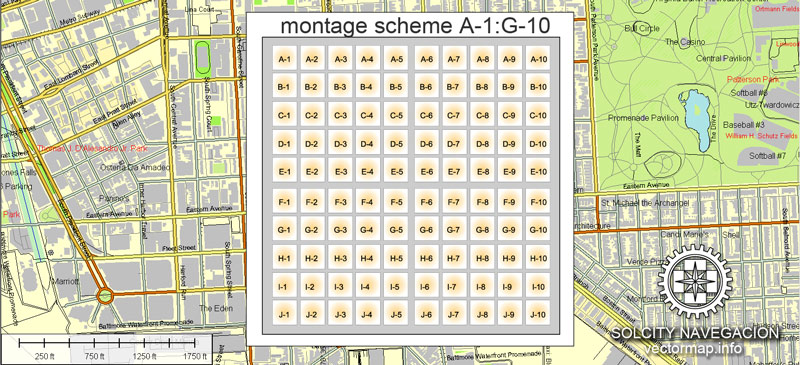
Content: Atlas 100 parts
[Available in PDF and other formats: .DWG; .AI; .EPS; .CDR; .PPT.]
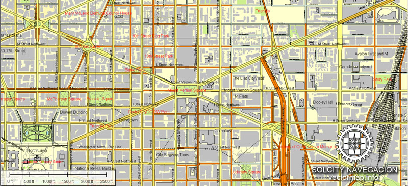
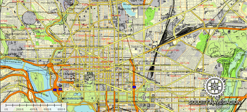
Washington and Baltimore vector maps in Adobe Illustrator format (.AI) features (check the preview images):
Highways with names,
Major streets with names,
Major Roads,
Dam,
National Park Borders,
Minor Roads,
Big and small Rivers, small streams also,
Lake, ponds and other water bodies,
Landmark fill,
Houses,
Railway
Recreation zones,
Parks.
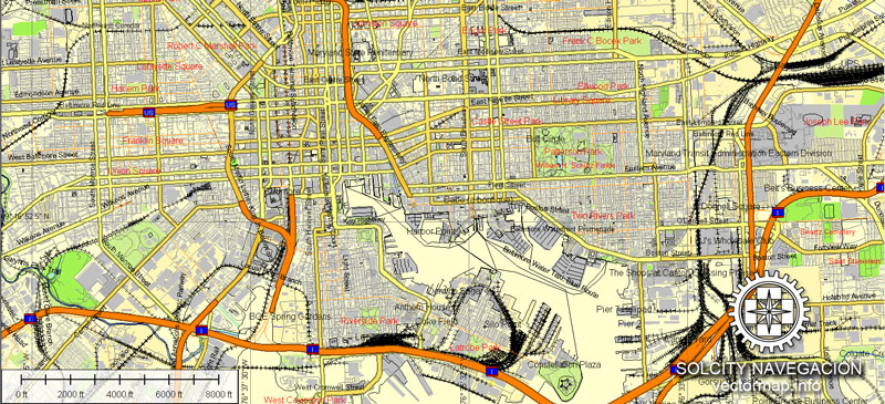
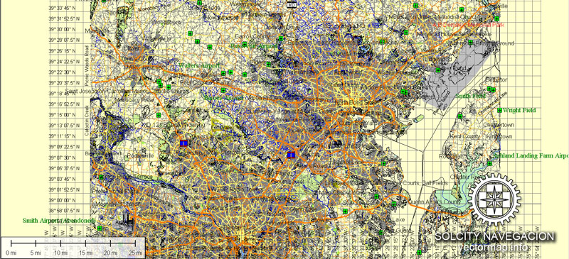
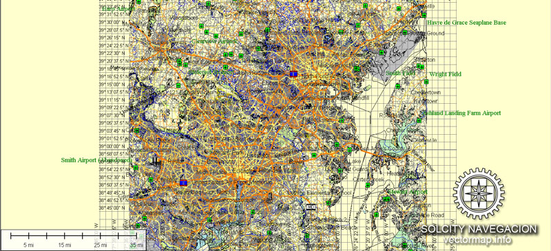
Washington DC + Baltimore, USA.
This vector map of Washington city is used as a basis for design, editing, and further printing.
This is the most detailed, exact map of Washington city for high-quality printing and polygraphy. You can always clarify the map development date by contacting us.
For your convenience, all objects on Washington vector city map are divided into layers. And the editing is very easy – colors, lines, etc.
You can easily add any objects needed (e.g. shops, salons, sale points, gas station or attraction) on any layer of Washington vector map.
One of the advantages of Washington city vector maps of our production is the relevance of cartographic data, we constantly update all our products.
Washington, D.C., formally the District of Columbia and commonly referred to as Washington or D.C., is the capital of the United States. Founded after the American Revolution as the seat of government of the newly independent country, Washington was named after George Washington, first President of the United States and Founding Father.
This vector map of Washington city is used by:
designers, layout designers, printers, advertisers and architects. Our product – vector maps – is designed for further editing and printing in large formats – from @Wall format (a few meters) to A-0 and A-1, A-2, A-3.
The Washington city map in vector format is used for design, urban planning, presentations and media visualizations.
The advertising and presentation map of Washington city (usually the final designer marks the routes, and puts the client’s objects (shops, saloons, gas stations etc.)
The undoubted advantage is that people will NEVER throw out this advertising product – the map. In fact, as an advertising medium, a city map is the most “long-playing” of the well-known polygraphic advertising media, with the longest lifespan, and the maximum number of interactions with the customer.
For travelers, maps are sold at the airports and gas stations around the world. Often the source is our vector maps.
Take a look, who purchases our vector maps of Washington city in “Our Clients and Friends” page – these are large and small companies, from super-brands like Volvo and Starbucks, to small design studios and printing houses.
It’s very easy to work with vector maps of Washington city, even for a not very experienced designer who can turn on and off the map layers, add new objects, change the colors of fill and lines according to customer requirements.
The undoubted advantage of Washington city vector maps in printing is an excellent and detailed visualization, when customer can expand a large paper map and instantly define his location, find a landmark, an object or address on map, unlike using the popular electronic formats of Google and Yandex maps for example.
Printable vector maps of Washington city are much more convenient and efficient than any electronic maps on your smartphone, because ALL DETAILS are displayed in the entire space of Washington city map.
Useful tips on working with vector maps of cities and countries in Adobe Illustrator.
«V» – launches the Selection tool (cursor, black arrow), which makes active any vector line.
«А» – launches the Direct Selection tool (white cursor), allows you to select curve elements and drag them to the desired place.
«R» – activates the Rotate tool, which helps you rotating selected objects around the center point by 360 degrees.
«E» – gives you the opportunity to use the Eraser tool and erase unnecessary parts.
«X» – switches between Fill and Stroke in the Tools section. Try to get used to this hot key and
you will quickly understand that you can’t live and work without it.
Guides are not limited to vertical and horizontal in Adobe Illustrator. You can also create a diagonal guide for example. Moreover, you can turn any contours into guides. Select the outline and go to View > Guides > Make Guides (Create Guides), or simply press Cmd/Ctrl + 5. You can also turn the guides back into an editable object. Go to menu, View > Guides > Unlock Guides (Release Guides), select the guide you want to edit and select View > Guides > Release Guides (Reset Guides), or just press Cmd/Ctrl + Option / Alt + 5).
Washington is the principal city of the Washington metropolitan area, which has a population of 6,131,977. As the seat of the United States federal government and several international organizations, the city is an important world political capital. Washington is one of the most visited cities in the world, with more than 20 million annual tourists.
You will probably want to change the color scheme used on our Washington vector city map.
To quickly and effectively play with colors.
Of course, you can do it manually, all objects in our Washington city vector map are divided according to types and layers, and you can easily change the color gamma of vector objects in groups and layers.
But there is more effective way of working with the whole VECTOR MAP of Washington city and all layers:
The overview dialog «Edit colors»/«Repaint Graphic Object» (this dialog box name can change depending on the context):
If you have selected a part or a layer of Washington city vector map and open the dialog box by clicking the icon in the Control panel, on the Samples palette or the Color Catalog, or if you choose Edit > Edit Colors> Repaint Graphic Object, then the «Repaint Graphic Object» dialog box appears, and you get access to «Assign» and «Edit» tabs.
If a picture or a map fragment is not selected, and you open the dialog box by clicking the icon in the Control panel, on the Samples palette or in the Color Catalog, the «Edit Colors» dialog box appears and you can only access the «Edit» tab.
The signing of the Residence Act on July 16, 1790, approved the creation of a capital district located along the Potomac River on the country’s East Coast. The U.S. Constitution provided for a federal district under the exclusive jurisdiction of the Congress, and the District is therefore not a part of any state. The states of Maryland and Virginia each donated land to form the federal district, which included the pre-existing settlements of Georgetown and Alexandria. The City of Washington was founded in 1791 to serve as the new national capital. In 1846, Congress returned the land originally ceded by Virginia; in 1871, it created a single municipal government for the remaining portion of the District.
Regardless of the name at the top of the dialog box, the right-hand side always displays the color group of the current document, as well as two default color groups: Print Color and Grayscale. These color groups can be selected and used any time.
Create and edit color groups of Washington city vector map, and also assign colors using the «Edit Colors»/ а «Repaint Graphic Object» dialog box.
A. Creating and editing of a color group on the «Edit» tab
B. Assigning colors on the «Assign» tab
C. Select a group of colors from the «Color groups» list
The option «Repaint a graphic object» in the lower part of the dialog box allows you to preview the colors on a selected layer of Vector map, or a group of elements, and specify whether its colors will be redefined when the dialog box is closed.
The main areas of the dialog box are:
«Edit»
The «Edit» tab is designed to create a new or edit the existing color groups.
The harmony rules Menu and the Color Wheel are used to conduct experiments with color harmonies. The color wheel shows how colors are related in color harmony, and the color bars allow you to view and manipulate an individual color values. In addition, you can adjust the brightness, add and remove colors, save color groups and view colors on the selected Vector Map of Washington city or a separated layers.
«Assign»
The «Assign» tab is used to view and control on how the original colors are replaced with colors from the color group like your corporate colors in the Vector Map of Washington city.
The assign color ability is provided only if the entire map, layer or fragment is selected in the document. You can specify which of new colors replace the current colors, whether the spot colors should be preserved and how colors are replaced (for example, you can replace colors completely or changing the color tone while maintaining the brightness). The «Assign» tab allows you to redefine colors in the Vector Map of Washington city, or in separate layers and fragments using the current color group or reducing the number of colors in the current Vector Map.
Color groups
Is a list of all saved color groups for current document (the same groups appear in the «Samples» palette). You can edit and delete the existing color groups, as well as creating a new ones using the list of “Color Groups” in the dialog box. All changes appear in the «Samples» palette.
The highlighted color group shows, which color group is currently edited.
Washington had an estimated population of 693,972 as of July 2017, making it the 20th largest American city by population. Commuters from the surrounding Maryland and Virginia suburbs raise the city’s daytime population to more than one million during the workweek. The Washington metropolitan area, of which the District is the principal city, has a population of over 6 million, the sixth-largest metropolitan statistical area in the country.
Any color group can be selected and edited, or used to redefine the colors in the selected vector map of Washington city, its fragments or elements.
Saving a color group adds this group to the specified list.
Opening the «Edit Colors»/«Repaint Graphic Object» dialog box.
Open the «Edit Colors»/«Repaint Graphic Object» dialog box using one of the following methods:
«Edit»> «Edit Colors»> «Repaint Graphic object» or «Repaint With Style».
Use these commands if you need to edit the colors in the selected vector map of Washington city.
«Repaint Graphic object» button on the «Control» panel.
Use this button if you need to adjust colors of Washington city vector map using the а «Repaint graphic object» dialog box.
All three branches of the U.S. federal government are centered in the District: U.S. Congress (legislative), President (executive), and the U.S. Supreme Court (judicial). Washington is home to many national monuments and museums, primarily situated on or around the National Mall. The city hosts 177 foreign embassies as well as the headquarters of many international organizations, trade unions, non-profit, lobbying groups, and professional associations, including the Organization of American States, AARP, the National Geographic Society, the Human Rights Campaign, the International Finance Corporation, and the American Red Cross.
The specified button is available if the selected vector map or its fragment contains two or more colors.
Note. This color editing method is convenient for global color adjustment in a vector map, if global colors were not used when creating a City Map of Washington.
The «Edit colors» button or «Edit or apply colors» on the «Color Catalog» palette
Click this button if you need to edit colors on the «Color Catalog» palette or edit and then apply them to the selected Vector Map of Washington city or its fragment.
The «Edit color group» button or «Edit or apply color group» on the «Samples» palette.
Click this button if you need to edit the colors in the specific color group or edit and apply them to the selected Vector Map of Washington city or a group of its elements, for example, the whole layer “Streets and lines”. You can also double-click the color group in the Samples panel to open the dialog box.
Geography
The Washington Metropolitan Area has a population of 6,131,977, as of 2014.
Washington, D.C., is located in the mid-Atlantic region of the U.S. East Coast. Due to the District of Columbia retrocession, the city has a total area of 68.34 square miles (177.0 km2), of which 61.05 square miles (158.1 km2) is land and 7.29 square miles (18.9 km2) (10.67%) is water. The District is bordered by Montgomery County, Maryland, to the northwest; Prince George’s County, Maryland, to the east; and Arlington and Alexandria, Virginia, to the south and west.
If the map file is too large and your computer freezes or even can’t open it quickly:
1. Try to reduce the color resolution of the video card (display) to 256 colors while working with a large map.
2. Using Windows Task Manager, select all the application you don’t need, while working with map, just turn them off.
3. Launch Adobe Illustrator. (DO NOT OPEN the vector map file)
4. Start the Windows Task Manager using administrator rights > Find the “Illustrator” process > set the «real time» priority,
5. Open the file. When you see the LEGACY FONT popup window – click “OK” (do not update). You can restore the TEXT later.
6. Can also be useful: When file is opened – Edit > Settings > Basic Settings > disable smoothing. /// It looks scary, but works quickly)))
We recommend saving the file in Adobe Illustrator 10 version. It’s much more stable when working with VERY BIG size files.
The south bank of the Potomac River forms the District’s border with Virginia and has two major tributaries: the Anacostia River and Rock Creek. Tiber Creek, a natural watercourse that once passed through the National Mall, was fully enclosed underground during the 1870s. The creek also formed a portion of the now-filled Washington City Canal, which allowed passage through the city to the Anacostia River from 1815 until the 1850s. The Chesapeake and Ohio Canal starts in Georgetown and was used during the 19th century to bypass the Little Falls of the Potomac River, located at the northwest edge of Washington at the Atlantic Seaboard fall line.
The highest natural elevation in the District is 409 feet (125 m) above sea level at Fort Reno Park in upper northwest Washington. The lowest point is sea level at the Potomac River. The geographic center of Washington is near the intersection of 4th and L Streets NW.
The District has 7,464 acres (30.21 km2) of parkland, about 19% of the city’s total area and the second-highest percentage among high-density U.S. cities. This factor contributed to Washington, D.C., being ranked as third in the nation for park access and quality in the 2018 ParkScore ranking of the park systems of the 100 most populous cities in the United States, according to the nonprofit Trust for Public Land.
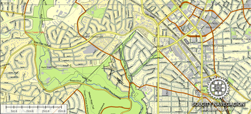
The National Park Service manages most of the 9,122 acres (36.92 km2) of city land owned by the U.S. government. Rock Creek Park is a 1,754-acre (7.10 km2) urban forest in Northwest Washington, which extends 9.3 miles (15.0 km) through a stream valley that bisects the city. Established in 1890, it is the country’s fourth-oldest national park and is home to a variety of plant and animal species, including raccoon, deer, owls, and coyotes. Other National Park Service properties include the C&O Canal National Historical Park, the National Mall and Memorial Parks, Theodore Roosevelt Island, Columbia Island, Fort Dupont Park, Meridian Hill Park, Kenilworth Park and Aquatic Gardens, and Anacostia Park. The D.C. Department of Parks and Recreation maintains the city’s 900 acres (3.6 km2) of athletic fields and playgrounds, 40 swimming pools, and 68 recreation centers. The U.S. Department of Agriculture operates the 446-acre (1.80 km2) U.S. National Arboretum in Northeast Washington.
Washington, D.C., in the United States, is located at 38°53′42″N 77°02′11″W (the coordinates of the Zero Milestone, on The Ellipse). According to the United States Census Bureau, the city has a geographical area of 68.3 square miles (176.9 km2), 61.4 square miles (159.0 km2) of which is land, and the remaining 6.9 square miles (17.9 km2) (10.16%) of which is water.
Washington is surrounded by the states of Virginia (on its southwest side) and Maryland (on its southeast, northeast, and northwest sides); it interrupts those states’ common border, which is the south shore of the Potomac River both upstream and downstream from the District. The portion of the Potomac River that passes Washington is virtually entirely within the District’s border, as the District extends to the south bank. The city contains the historic “federal city”, the territory of which was formerly part of those two adjacent states before they respectively ceded it for the national capital. The land ceded from Virginia was returned by Congress in 1847, so what remains of the modern District was all once part of Maryland.
Topography and geology
The topography of the District of Columbia is very similar to the physical geography of much of Maryland. The District has three major natural flowing bodies of water: the Potomac River and two tributaries, the Anacostia River and Rock Creek. The confluence of the Potomac and Anacostia forms the historic peninsula known as Arsenal Point. The District also includes the Washington Channel, which flows into the junction of the Anacostia and Potomac rivers. There are also three man-made reservoirs: Dalecarlia Reservoir, which crosses over the northwest border of the District from Maryland, McMillan Reservoir near Howard University, and Georgetown Reservoir upstream of Georgetown. A fourth, minor reservoir is at Fort Reno.
Cityscape
Washington, D.C., is a planned city. In 1791, President Washington commissioned Pierre (Peter) Charles L’Enfant, a French-born architect and city planner, to design the new capital. He enlisted Scottish surveyor Alexander Ralston to help lay out the city plan. The L’Enfant Plan featured broad streets and avenues radiating out from rectangles, providing room for open space and landscaping. He based his design on plans of cities such as Paris, Amsterdam, Karlsruhe, and Milan that Thomas Jefferson had sent to him. L’Enfant’s design also envisioned a garden-lined “grand avenue” approximately 1 mile (1.6 km) in length and 400 feet (120 m) wide in the area that is now the National Mall. President Washington dismissed L’Enfant in March 1792 due to conflicts with the three commissioners appointed to supervise the capital’s construction. Andrew Ellicott, who had worked with L’Enfant surveying the city, was then tasked with completing the design. Though Ellicott made revisions to the original plans, including changes to some street patterns, L’Enfant is still credited with the overall design of the city.
A tall red brick building in the center of a city skyline punctuated by steeples and other shorter buildings.

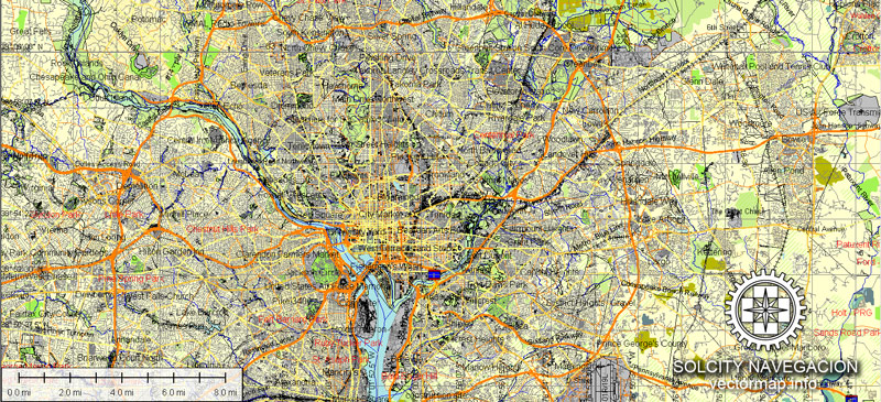
The Baltimore–Washington metropolitan area is a combined statistical area consisting of the overlapping labor market region of the cities of Washington, D.C. and Baltimore, Maryland. The region includes Central Maryland, Northern Virginia, three counties in the Eastern Panhandle of West Virginia, and one county in South Central Pennsylvania. It is the most educated, highest-income, and fourth largest combined statistical area in the United States.
Baltimore
City in Maryland
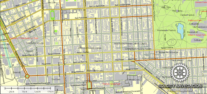
Baltimore is a major city in Maryland with a long history as an important seaport. Fort McHenry, birthplace of the U.S. national anthem, “The Star-Spangled Banner,” sits at the mouth of Baltimore’s Inner Harbor. Today, this harbor area offers shops, upscale crab shacks and attractions like the Civil War–era warship the USS Constellation and the National Aquarium, showcasing thousands of marine creatures.
We provide detailed maps of Washington and Baltimore (USA) in AI. Being vector maps, they are completely editable, and scalable. No matter what big is the print size you need (office wall mural o bigboard). Zoom without quality degradation.
Please also check other vector maps of USA cities.
.
You can edit all map data using different vector graphics editors like Adobe Illustrator, Freehand or CorelDraw, cropping, changing colors, fonts or borders, also adding your company logo or necessary objects. And also is a fully scalable map, no matter what size you need.
This vector maps of Washington and Baltimore are available in different vector formats (the same price): .AI, .CDR .DWG, .DXF, .EPS, .PDF.
Royalty Free license. You don`t pay extra: per volume sold; for each use; for period of use.
If you need a vector map of different area, or need more objects to be shown on map, just contact our friendly team, and we add it with no extra cost.
Washington and Baltimore maps in vector. Cities and counties near
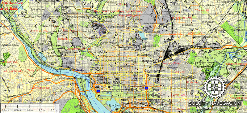
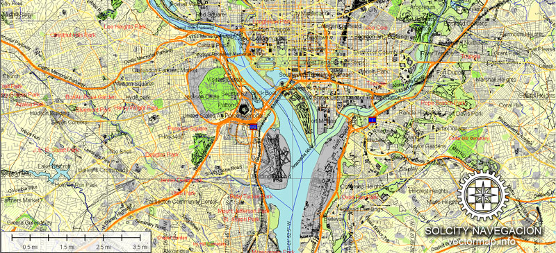
Our vector map of Washington and Baltimore includes maps of the nearest areas (see the preview):
Bitter Lake, North Seattle, Greenwood, Northeast Seattle, Ravenna, Sand Point, Windermere, Old Ballard, West Woodland, Fremont, Wallingford, Laurelhurst, Eastlake, Capitol Hill, White Center, Kerry Park, Magnolia, Interbay, Bellevue, Medina, Columbia City, Industrial District, West Seattle, Factoria, Totem Lake, Bridle Trails, Redmond, Kingsgate, Kirkland, Bothell, Woodinville, Shoreline, Lynnwood, Edmonds, Esperance, Venice, Agate Point, Crystal Springs.
Washington and Baltimore maps for Adobe Illustrator. Purchasing and downloading.
We accept PayPal and Credit Card payment. After the payment you will be redirected to the download page.
The biggest base of Vector Maps. Maps containing streets with names, buildings, railways, airports or other objects needed.
Small guide: How to work with the vector map?
You can: Mass select objects by type and color – for example, the objects type “building” (they are usually dark gray) – and remove them from the map, if you do not need them in your print or design project. You can also easily change the thickness of lines (streets), just bulk selection the road by the line color.
The streets are separated by type, for example, type “residential road” are usually white with a gray stroke. Highway usually orange with a brown or dark gray stroke.
All objects are divided by types: different types of roads and streets, polygons of buildings, landfills, urban areas, parks and more other.
It is easy to change the font of inscriptions, all or each individually. Also, just can be make and any other manipulation of objects on the vector map in Adobe illustrator format.
Important: All the proportions on the map are true, that is, the relative sizes of the objects are true, because Map is based on an accurate GPS projection, and It transated into the (usual for all) the Mercator projection.
You can easily change the color, stroke and fill of any object on the map, zoom without loss of quality Image Verification.
Select object

Bulk selection the same objects on the vector map

See the bulk selected objects on the vector map

Bulk delete buildungs from the vector map

Select residencial road (small street) on the vector map

Bulk selection the same lines (streets, roads) on the full map

Create fat lines of the streets on the vector maps (bulk action) 1

Create fat lines of the streets on the vector maps (bulk action) 2

Create fat lines of the streets on the vector maps (bulk action) 3

You can easily change the color, stroke and fill of any object on the map, zoom without loss of quality Image Verification.
Washington, D.C., formally the District of Columbia and commonly referred to as “Washington”, “the District”, or simply “D.C.”, is the capital of the United States. The signing of the Residence Act on July 16, 1790, approved the creation of a capital district located along the Potomac River on the country’s East Coast. The U.S. Constitution provided for a federal district under the exclusive jurisdiction of the Congress and the District is therefore not a part of any state.
The states of Maryland and Virginia each donated land to form the federal district, which included the pre-existing settlements of Georgetown and Alexandria. Named in honor of President George Washington, the City of Washington was founded in 1791 to serve as the new national capital. In 1846, Congress returned the land originally ceded by Virginia; in 1871, it created a single municipal government for the remaining portion of the District.
Washington had an estimated population of 672,228 as of July 2015. Commuters from the surrounding Maryland and Virginia suburbs raise the city’s population to more than one million during the workweek. The Washington vector map metropolitan area, of which the District is a part, has a population of over 6 million, the sixth-largest metropolitan statistical area in the country.
The centers of all three branches of the federal government of the United States are in the District, including the Congress, President, and Supreme Court. Washington is home to many national monuments and museums, which are primarily situated on or around the National Mall. The city hosts 176 foreign embassies as well as the headquarters of many international organizations, trade unions, non-profit organizations, lobbying groups, and professional associations.
A locally elected mayor and a 13‑member council have governed the District since 1973. However, the Congress maintains supreme authority over the city and may overturn local laws. D.C. residents elect a non-voting, at-large congressional delegate to the House of Representatives, but the District has no representation in the Senate. The District receives three electoral votes in presidential elections as permitted by the Twenty-third Amendment to the United States Constitution, ratified in 1961.
Geography of Washington
Main article: Geography of Washington, D.C.
The Chesapeake and Ohio Canal passes through the Georgetown neighborhood.
Washington, D.C., is located in the mid-Atlantic region of the U.S. East Coast. Due to the District of Columbia retrocession, the city has a total area of 68.34 square miles (177.0 km2), of which 61.05 square miles (158.1 km2) is land and 7.29 square miles (18.9 km2) (10.67%) is water. The District is bordered by Montgomery County, Maryland, to the northwest; Prince George’s County, Maryland, to the east; and Arlington and Alexandria, Virginia, to the south and west.
The south bank of the Potomac River forms the District’s border with Virginia and has two major tributaries: the Anacostia River and Rock Creek. Tiber Creek, a natural watercourse that once passed through the National Mall, was fully enclosed underground during the 1870s. The creek also formed a portion of the now-filled Washington City map vector Canal, which allowed passage through the city to the Anacostia River from 1815 until the 1850s. The Chesapeake and Ohio Canal starts in Georgetown and was used during the 19th century to bypass the Little Falls of the Potomac River, located at the northwest edge of Washington at the Atlantic Seaboard fall line.
The highest natural elevation in the District is 409 feet (125 m) above sea level at Fort Reno Park in upper northwest Washington. The lowest point is sea level at the Potomac River.[46] The geographic center of Washington pdf map is near the intersection of 4th and L Streets NW. Contrary to the urban legend, Washington was not built on a reclaimed swamp, but wetlands did cover areas along the water.
The District has 7,464 acres (30.21 km2) of parkland, about 19% of the city’s total area and the second-highest percentage among high-density U.S. cities. The National Park Service manages most of the 9,122 acres (36.92 km2) of city land owned by the U.S. government. Rock Creek Park is a 1,754-acre (7.10 km2) urban forest in Northwest Washington, which extends 9.3 miles (15.0 km) through a stream valley that bisects the city. Established in 1890, it is the country’s fourth-oldest national park and is home to a variety of plant and animal species including raccoon, deer, owls, and coyotes. Other National Park Service properties include the C&O Canal National Historical Park, the National Mall and Memorial Parks, Theodore Roosevelt Island, Columbia Island, Fort Dupont Park, Meridian Hill Park, Kenilworth Park and Aquatic Gardens, and Anacostia Park. The D.C. Department of Parks and Recreation maintains the city’s 900 acres (3.6 km2) of athletic fields and playgrounds, 40 swimming pools, and 68 recreation centers. The U.S. Department of Agriculture operates the 446-acre (1.80 km2) U.S. National Arboretum in Northeast Washington.
Baltimore is the largest city in the U.S. state of Maryland, and the 29th-most populous city in the country. It was established by the Constitution of Maryland[9] and is not part of any county; thus, it is the largest independent city in the United States. Baltimore has more public monuments per capita than any other city in the country and is home to some of the earliest National Register historic districts in the nation, including Fell’s Point (1969), Federal Hill (1970) and Mount Vernon Place (1971). More than 65,000 properties, or roughly one in three buildings in the city, are listed on the National Register, more than any other city in the nation.
Founded in 1729, Baltimore is the second largest seaport in the Mid-Atlantic. Baltimore’s Inner Harbor was once the second leading port of entry for immigrants to the United States and a major manufacturing center. After a decline in major manufacturing, industrialization and rail transportation, Baltimore shifted to a service-oriented economy, with the Johns Hopkins Hospital (founded 1889), and Johns Hopkins University (founded 1876), now the city’s top two employers.
Baltimore had a population of 621,849 in 2015; in 2010, that of Baltimore Metropolitan Area was 2.7 million, the 21st largest in the country.
With hundreds of identified districts, Baltimore has been dubbed “a city of neighborhoods”. Famous residents have included the writers Edgar Allan Poe, Edith Hamilton, Frederick Douglass, and H.L. Mencken; jazz musician James “Eubie” Blake; singer Billie Holiday; actor and filmmaker John Waters; and baseball player Babe Ruth. In the War of 1812, Francis Scott Key wrote The Star-Spangled Banner, later the American national anthem, in the city.
Geography of Baltimore
Baltimore is in north-central Maryland on the Patapsco River close to where it empties into the Chesapeake Bay. The city is also located on the fall line between the Piedmont Plateau and the Atlantic Coastal Plain, which divides Baltimore vector map into “lower city” and “upper city”. The city’s elevation ranges from sea level at the harbor to 480 feet (150 m) in the northwest corner near Pimlico.
According to the 2010 Census, the city has a total area of 92.1 square miles (239 km2), of which 80.9 sq mi (210 km2) is land and 11.1 sq mi (29 km2) is water. The total area is 12.1 percent water.
Baltimore is almost completely surrounded by Baltimore printable map County, but is politically independent of it. It is bordered by Anne Arundel County to the south.
Source
See more Printable and editable maps of USA cities
For example: Austin printable street map plan, Texas
Albany New York USA Printable vector street city plan map
Boston printable vector street map fully editable Adobe Illustrator

 Author: Kirill Shrayber, Ph.D. FRGS
 City Plan editable Adobe Illustrator Street Map in layers")
