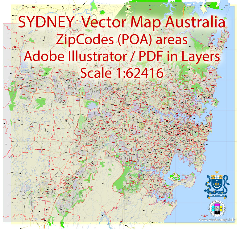
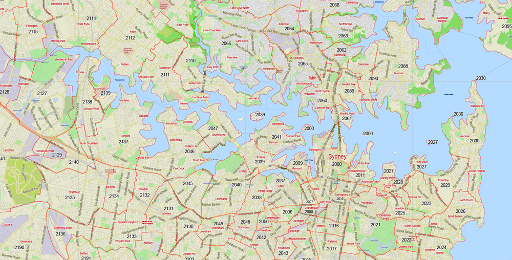
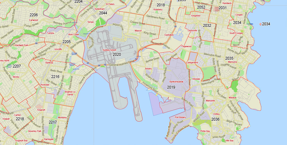
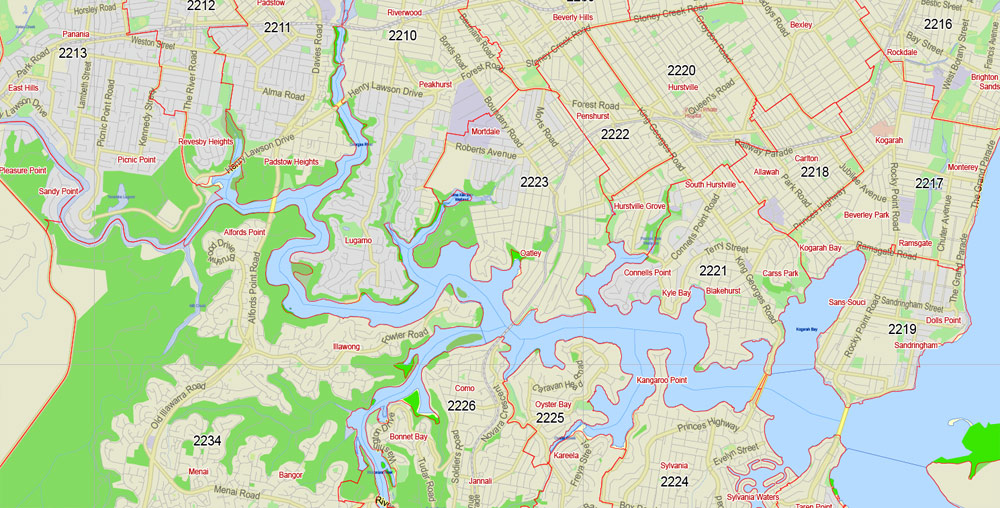
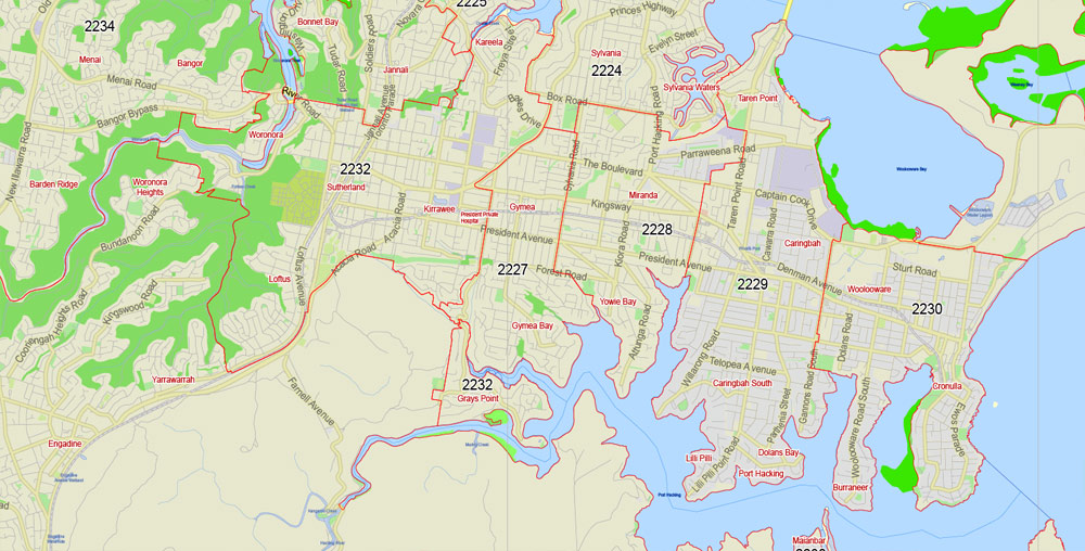
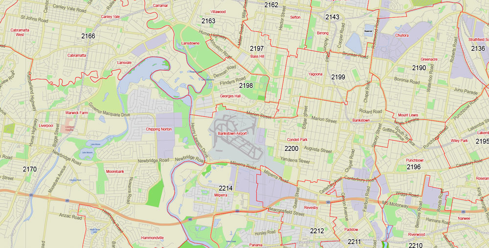
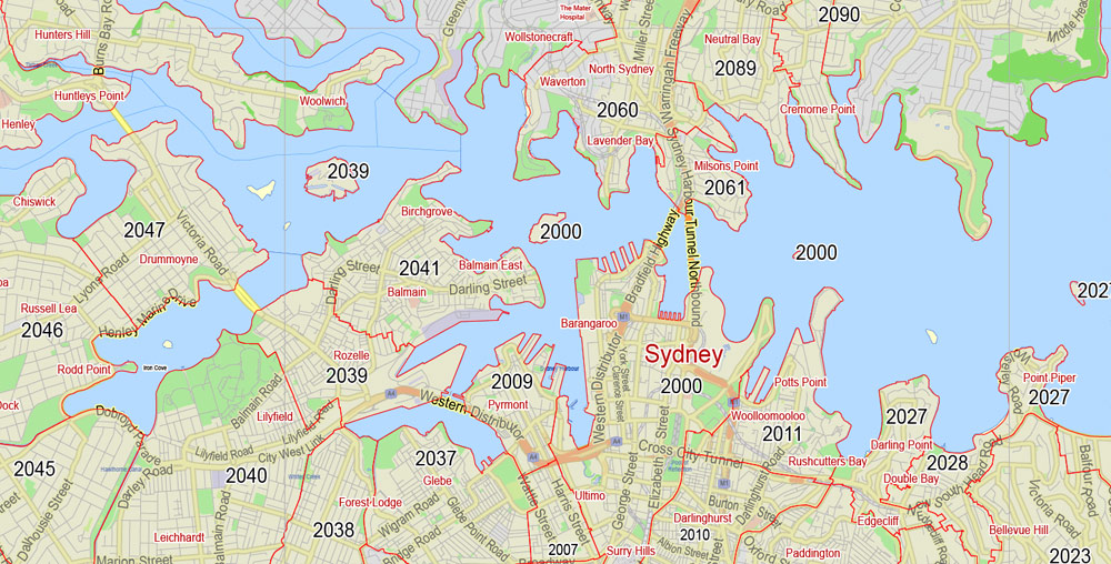
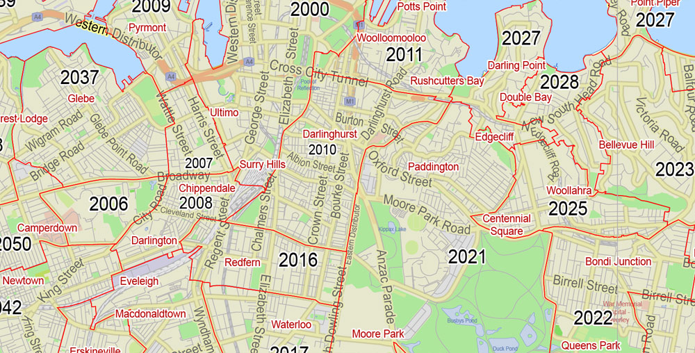
Printable Vector Map Sydney, Australia, exact City Plan, full editable, Adobe Illustrator, scale 1:62416, scalable, text format all names, all ZIPcodes areas (POA) Street Map, 9 Mb ZIP.
Principal streets named, main objects. Map for publishing, design, printing, publications, arts, projects, presentations, for architects, designers and builders, business, logistics. The most exact and detailed map of the city.
Separated layers: streets_roads, names_streets, names_objects, ZipCodes_polygobs, ZipCodes_areas_borders, ZipCodes_areas_numbers, color_fills, Names_places, labels_roads, grids, etc.
For High Quality Printing.
DWG, DXF, CDR and other formats – by request, same price, please contact.
Sydney, New South Wales, Australia.
This vector map of Sydney city is used as a basis for design, editing, and further printing.
This is the most detailed, exact map of Sydney city for high-quality printing and polygraphy. You can always clarify the map development date by contacting us.
For your convenience, all objects on Sydney vector city map are divided into layers. And the editing is very easy – colors, lines, etc.
You can easily add any objects needed (e.g. shops, salons, sale points, gas station or attraction) on any layer of Sydney vector map.
One of the advantages of Sydney city vector maps of our production is the relevance of cartographic data, we constantly update all our products.
Sydney is the state capital of New South Wales and the most populous city in Australia and Oceania. Located on Australia’s east coast, the metropolis surrounds Port Jackson and extends about 70 km (43.5 mi) on its periphery towards the Blue Mountains to the west, Hawkesbury to the north, and Macarthur to the south. Sydney is made up of 658 suburbs, 40 local government areas and 15 contiguous regions. Residents of the city are known as “Sydneysiders”. As of June 2017, Sydney’s estimated metropolitan population was 5,131,326.
This vector map of Sydney city is used by:
designers, layout designers, printers, advertisers and architects. Our product – vector maps – is designed for further editing and printing in large formats – from @Wall format (a few meters) to A-0 and A-1, A-2, A-3.
The Sydney city map in vector format is used for design, urban planning, presentations and media visualizations.
The advertising and presentation map of Sydney city (usually the final designer marks the routes, and puts the client’s objects (shops, saloons, gas stations etc.)
The undoubted advantage is that people will NEVER throw out this advertising product – the map. In fact, as an advertising medium, a city map is the most “long-playing” of the well-known polygraphic advertising media, with the longest lifespan, and the maximum number of interactions with the customer.
For travelers, maps are sold at the airports and gas stations around the world. Often the source is our vector maps.
Take a look, who purchases our vector maps of Sydney city in “Our Clients and Friends” page – these are large and small companies, from super-brands like Volvo and Starbucks, to small design studios and printing houses.
Indigenous Australians have inhabited the Sydney area for at least 30,000 years, and it remains one of the richest in Australia in terms of Aboriginal archaeological sites, with thousands of engravings located throughout the region.
It’s very easy to work with vector maps of Sydney city, even for a not very experienced designer who can turn on and off the map layers, add new objects, change the colors of fill and lines according to customer requirements.
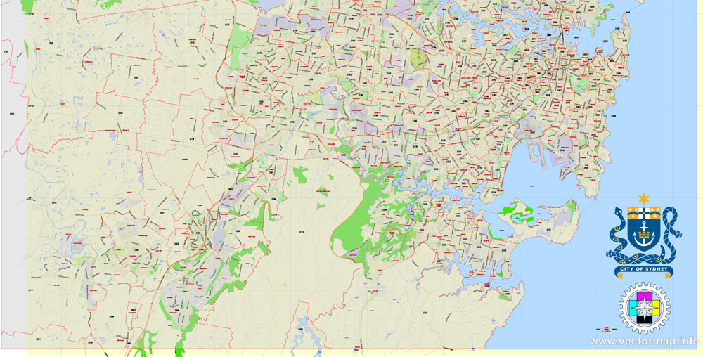
The undoubted advantage of Sydney city vector maps in printing is an excellent and detailed visualization, when customer can expand a large paper map and instantly define his location, find a landmark, an object or address on map, unlike using the popular electronic formats of Google and Yandex maps for example.
Printable vector maps of Sydney city are much more convenient and efficient than any electronic maps on your smartphone, because ALL DETAILS are displayed in the entire space of Sydney city map.
Useful tips on working with vector maps of cities and countries in Adobe Illustrator.
«V» – launches the Selection tool (cursor, black arrow), which makes active any vector line.
«А» – launches the Direct Selection tool (white cursor), allows you to select curve elements and drag them to the desired place.
«R» – activates the Rotate tool, which helps you rotating selected objects around the center point by 360 degrees.
«E» – gives you the opportunity to use the Eraser tool and erase unnecessary parts.
«X» – switches between Fill and Stroke in the Tools section. Try to get used to this hot key and
you will quickly understand that you can’t live and work without it.
Guides are not limited to vertical and horizontal in Adobe Illustrator. You can also create a diagonal guide for example. Moreover, you can turn any contours into guides. Select the outline and go to View > Guides > Make Guides (Create Guides), or simply press Cmd/Ctrl + 5. You can also turn the guides back into an editable object. Go to menu, View > Guides > Unlock Guides (Release Guides), select the guide you want to edit and select View > Guides > Release Guides (Reset Guides), or just press Cmd/Ctrl + Option / Alt + 5).
You will probably want to change the color scheme used on our Sydney vector city map.
To quickly and effectively play with colors.
Of course, you can do it manually, all objects in our Sydney city vector map are divided according to types and layers, and you can easily change the color gamma of vector objects in groups and layers.
But there is more effective way of working with the whole VECTOR MAP of Sydney city and all layers:
The overview dialog «Edit colors»/«Repaint Graphic Object» (this dialog box name can change depending on the context):
If you have selected a part or a layer of Sydney city vector map and open the dialog box by clicking the icon in the Control panel, on the Samples palette or the Color Catalog, or if you choose Edit > Edit Colors> Repaint Graphic Object, then the «Repaint Graphic Object» dialog box appears, and you get access to «Assign» and «Edit» tabs.
In 1770, during his first Pacific voyage in the Endeavour, Lieutenant James Cook, after leaving Botany Bay, saw the entrance to Port Jackson, but sailed past and did not enter the inlet. In 1788, the First Fleet of convicts, led by Arthur Phillip, were the first recorded Europeans to sail into Port Jackson. Here they founded Sydney as a British penal colony, the first European settlement in Australia. Phillip named the city “Sydney” in recognition of Thomas Townshend, 1st Viscount Sydney. Penal transportation to New South Wales ended soon after Sydney was incorporated as a city in 1842.
If a picture or a map fragment is not selected, and you open the dialog box by clicking the icon in the Control panel, on the Samples palette or in the Color Catalog, the «Edit Colors» dialog box appears and you can only access the «Edit» tab.
Regardless of the name at the top of the dialog box, the right-hand side always displays the color group of the current document, as well as two default color groups: Print Color and Grayscale. These color groups can be selected and used any time.
Create and edit color groups of Sydney city vector map, and also assign colors using the «Edit Colors»/ а «Repaint Graphic Object» dialog box.
A. Creating and editing of a color group on the «Edit» tab
B. Assigning colors on the «Assign» tab
C. Select a group of colors from the «Color groups» list
The option «Repaint a graphic object» in the lower part of the dialog box allows you to preview the colors on a selected layer of Vector map, or a group of elements, and specify whether its colors will be redefined when the dialog box is closed.
A gold rush occurred in the colony in 1851, and over the next century, Sydney transformed from a colonial outpost into a major global cultural and economic centre. After World War II, it experienced mass migration and became one of the most multicultural cities in the world. At the time of the 2011 census, more than 250 different languages were spoken in Sydney and about 40 percent of residents spoke a language other than English at home. Furthermore, 36% of the population reported having been born overseas.
The main areas of the dialog box are:
«Edit»
The «Edit» tab is designed to create a new or edit the existing color groups.
The harmony rules Menu and the Color Wheel are used to conduct experiments with color harmonies. The color wheel shows how colors are related in color harmony, and the color bars allow you to view and manipulate an individual color values. In addition, you can adjust the brightness, add and remove colors, save color groups and view colors on the selected Vector Map of Sydney city or a separated layers.
«Assign»
The «Assign» tab is used to view and control on how the original colors are replaced with colors from the color group like your corporate colors in the Vector Map of Sydney city.
The assign color ability is provided only if the entire map, layer or fragment is selected in the document. You can specify which of new colors replace the current colors, whether the spot colors should be preserved and how colors are replaced (for example, you can replace colors completely or changing the color tone while maintaining the brightness). The «Assign» tab allows you to redefine colors in the Vector Map of Sydney city, or in separate layers and fragments using the current color group or reducing the number of colors in the current Vector Map.
Color groups
Is a list of all saved color groups for current document (the same groups appear in the «Samples» palette). You can edit and delete the existing color groups, as well as creating a new ones using the list of “Color Groups” in the dialog box. All changes appear in the «Samples» palette.
The highlighted color group shows, which color group is currently edited.
Any color group can be selected and edited, or used to redefine the colors in the selected vector map of Sydney city, its fragments or elements.
Saving a color group adds this group to the specified list.
Opening the «Edit Colors»/«Repaint Graphic Object» dialog box.
Open the «Edit Colors»/«Repaint Graphic Object» dialog box using one of the following methods:
«Edit»> «Edit Colors»> «Repaint Graphic object» or «Repaint With Style».
Use these commands if you need to edit the colors in the selected vector map of Sydney city.
«Repaint Graphic object» button on the «Control» panel.
Use this button if you need to adjust colors of Sydney city vector map using the а «Repaint graphic object» dialog box.
The specified button is available if the selected vector map or its fragment contains two or more colors.
Note. This color editing method is convenient for global color adjustment in a vector map, if global colors were not used when creating a City Map of Sydney.
The «Edit colors» button or «Edit or apply colors» on the «Color Catalog» palette
Click this button if you need to edit colors on the «Color Catalog» palette or edit and then apply them to the selected Vector Map of Sydney city or its fragment.
Despite being one of the most expensive cities in the world, the 2018 Mercer Quality of Living Survey ranks Sydney tenth in the world in terms of quality of living, making it one of the most livable cities. It is classified as an Alpha World City by Globalization and World Cities Research Network, indicating its influence in the region and throughout the world.
The «Edit color group» button or «Edit or apply color group» on the «Samples» palette.
Click this button if you need to edit the colors in the specific color group or edit and apply them to the selected Vector Map of Sydney city or a group of its elements, for example, the whole layer “Streets and lines”. You can also double-click the color group in the Samples panel to open the dialog box.
If the map file is too large and your computer freezes or even can’t open it quickly:
1. Try to reduce the color resolution of the video card (display) to 256 colors while working with a large map.
2. Using Windows Task Manager, select all the application you don’t need, while working with map, just turn them off.
3. Launch Adobe Illustrator. (DO NOT OPEN the vector map file)
4. Start the Windows Task Manager using administrator rights > Find the “Illustrator” process > set the «real time» priority,
5. Open the file. When you see the LEGACY FONT popup window – click “OK” (do not update). You can restore the TEXT later.
6. Can also be useful: When file is opened – Edit > Settings > Basic Settings > disable smoothing. /// It looks scary, but works quickly)))
We recommend saving the file in Adobe Illustrator 10 version. It’s much more stable when working with VERY BIG size files.
Ranked eleventh in the world for economic opportunity, Sydney has an advanced market economy with strengths in finance, manufacturing and tourism. There is a significant concentration of foreign banks and multinational corporations in Sydney and the city is promoted as one of Asia Pacific’s leading financial hubs. Established in 1850, the University of Sydney is Australia’s first university and is regarded as one of the world’s leading universities. Sydney is also home to the oldest library in Australia, State Library of New South Wales, opened in 1826.
Sydney has hosted major international sporting events such as the 2000 Summer Olympics. The city is among the top fifteen most-visited cities in the world, with millions of tourists coming each year to see the city’s landmarks. Boasting over 1,000,000 ha (2,500,000 acres) of nature reserves and parks, its notable natural features include Sydney Harbour, the Royal National Park, Royal Botanic Garden and Hyde Park, the oldest parkland in the country. Built attractions such as the Sydney Harbour Bridge and the World Heritage-listed Sydney Opera House are also well known to international visitors. The main passenger airport serving the metropolitan area is Kingsford-Smith Airport, one of the world’s oldest continually operating airports. Established in 1906, Central station, the largest and busiest railway station in the state, is the main hub of the city’s rail network.
Geography
Topography
Sydney is a coastal basin with the Tasman Sea to the east, the Blue Mountains to the west, the Hawkesbury River to the north, and the Woronora Plateau to the south. The inner city measures 25 square kilometres (10 square miles), the Greater Sydney region covers 12,367 square kilometres (4,775 square miles), and the city’s urban area is 1,687 square kilometres (651 square miles) in size.
Sydney spans two geographic regions. The Cumberland Plain lies to the south and west of the Harbour and is relatively flat. The Hornsby Plateau is located to the north and is dissected by steep valleys. The flat areas of the south were the first to be developed as the city grew. It was not until the construction of the Sydney Harbour Bridge that the northern reaches of the coast became more heavily populated. Seventy beaches can be found along its coastline with Bondi Beach being one of the most famous.
The Nepean River wraps around the western edge of the city and becomes the Hawkesbury River before reaching Broken Bay. Most of Sydney’s water storages can be found on tributaries of the Nepean River. The Parramatta River is mostly industrial and drains a large area of Sydney’s western suburbs into Port Jackson. The southern parts of the city are drained by the Georges River and the Cooks River into Botany Bay.
Inner suburbs
The CBD extends about 3 kilometres (1.9 miles) south from Sydney Cove. It is bordered by Farm Cove within the Royal Botanic Garden to the east and Darling Harbour to the west. Suburbs surrounding the CBD include Woolloomooloo and Potts Point to the east, Surry Hills and Darlinghurst to the south, Pyrmont and Ultimo to the west, and Millers Point and The Rocks to the north. Most of these suburbs measure less than 1 square kilometre (0.4 square miles) in area. The Sydney CBD is characterised by considerably narrow streets and thoroughfares, created in its convict beginnings in the 18th century.
Several localities, distinct from suburbs, exist throughout Sydney’s inner reaches. Central and Circular Quay are transport hubs with ferry, rail, and bus interchanges. Chinatown, Darling Harbour, and Kings Cross are important locations for culture, tourism, and recreation. The Strand Arcade, which is located between Pitt Street Mall and George Street, is a historical Victorian-style shopping arcade. Opened on 1 April 1892, its shop fronts are an exact replica of the original internal shopping facades. Westfield Sydney, located beneath the Sydney Tower, is the largest shopping centre by area in Sydney.
There is a long trend of gentrification amongst Sydney’s inner suburbs. Pyrmont located on the harbour was redeveloped from a centre of shipping and international trade to an area of high density housing, tourist accommodation, and gambling. Originally located well outside of the city, Darlinghurst is the location of a former gaol, manufacturing, and mixed housing. It had a period when it was known as an area of prostitution. The terrace style housing has largely been retained and Darlinghurst has undergone significant gentrification since the 1980s.
Green Square is a former industrial area of Waterloo which is undergoing urban renewal worth $8 billion. On the city harbour edge the historic suburb and wharves of Millers Point are being built up as the new area of Barangaroo. The enforced rehousing of local residents due to the Millers Point/Barangaroo development has caused significant controversy despite the $6 billion worth of economic activity it is expected to generate. The suburb of Paddington is a well known suburb for its streets of restored terrace houses, Victoria Barracks, and shopping including the weekly Oxford Street markets.
Inner West
King Street in Newtown is one of the most complete Victorian and Edwardian era commercial precincts in Australia.
The Inner West generally includes the Inner West Council, Municipality of Burwood, Municipality of Strathfield, and City of Canada Bay. These span up to about 11 km west of the CBD. Suburbs in the Inner West have historically housed working class industrial workers, but have undergone gentrification over the 20th century. The region now mainly features medium- and high-density housing. Major features in the area include the University of Sydney and the Parramatta River, as well as a large cosmopolitan community. The Anzac Bridge spans Johnstons Bay and connects Rozelle to Pyrmont and the City, forming part of the Western Distributor.
The area is serviced by the T1, T2, and T3 railway lines, including the Main Suburban Line; which is the first to be constructed in New South Wales. Strathfield Railway Station is a secondary railway hub within Sydney, and major station on the Suburban and Northern lines. It was constructed in 1876, and will be a future terminus of Parramatta Light Rail. The area is also serviced by numerous bus routes and cycleways. Other shopping centres in the area include Westfield Burwood and DFO in Homebush.
Eastern suburbs
The Eastern Suburbs encompass the Municipality of Woollahra, the City of Randwick, the Waverley Municipal Council, and parts of the Bayside Council. The Greater Sydney Commission envisions a resident population of 1,338,250 people by 2036 in its Eastern City District (including the City and Inner West).
They include some of the most affluent and advantaged areas in the country, with some streets being amongst the most expensive in the world. Wolseley Road, in Point Piper, has a top price of $20,900 per square metre, making it the ninth-most expensive street in the world. More than 75% of neighbourhoods in the Electoral District of Wentworth fall under the top decile of SEIFA advantage, making it the least disadvantaged area in the country.
Major landmarks include Bondi Beach, a major tourist site; which was added to the Australian National Heritage List in 2008; and Bondi Junction, featuring a Westfield shopping centre and an estimated office work force of 6,400 by 2035, as well as a train station on the T4 Eastern Suburbs Line. The suburb of Randwick contains the Randwick Racecourse, the Royal Hospital for Women, the Prince of Wales Hospital, Sydney Children’s Hospital, and the UNSW Kensington Campus. Randwick’s ‘Collaboration Area’ has a baseline estimate of 32,000 jobs by 2036, according to the Greater Sydney Commission.
Construction is underway for the CBD and South East Light Rail line. Although main construction was due to complete in 2018, completion has potentially been delayed to March 2020. The project aims to provide reliable and high-capacity tram services to residents in the City and South-East.
Major shopping centres in the area include Westfield Bondi Junction and Westfield Eastgardens, although many residents shop in the City.
Southern Sydney
Southern Sydney includes the suburbs in the local government areas of former Rockdale, Georges River Council (collectively known as the St George area), and broadly it also includes the suburbs in the local government area of Sutherland, south of the Georges River (colloquially known as ‘The Shire’).
The Kurnell peninsula, near Botany Bay, is the site of the first landfall on the eastern coastline made by Lt. (later Captain) James Cook in 1770. La Perouse, a historic suburb named after the French navigator Jean-François de Galaup, comte de Lapérouse (1741–88), is notable for its old military outpost at Bare
The suburb of Cronulla in southern Sydney is close to Royal National Park, Australia’s oldest national park. Hurstville, a large suburb with a multitude of commercial buildings and high-rise residential buildings dominating the skyline, has become a CBD for the southern suburbs.
Northern suburbs
North Sydney commercial district.
Because ‘Northern Suburbs’ is not a clearly defined region, ‘Northern Suburbs’ may also include the suburbs in the Upper North Shore, Lower North Shore and the Northern Beaches.
The Northern Suburbs include several landmarks – Macquarie University, Gladesville Bridge, Ryde Bridge, Macquarie Centre and Curzon Hall in Marsfield. This area includes suburbs in the local government areas of Hornsby Shire, City of Ryde, the Municipality of Hunter’s Hill and parts of the City of Parramatta.
The North Shore, an informal geographic term referring to the northern metropolitan area of Sydney, consists of Artarmon, Chatswood, Roseville, Lindfield, Killara, Gordon, Pymble, Hornsby and many others. The North Shore, an upper middle class area, has one of the highest property prices in Sydney with the recent property price inflation sending the average property prices in suburbs such as Roseville, Lindfield, Killara and Gordon over 2 million dollars.
The Lower North Shore usually refers to the suburbs adjacent to the harbour such as Neutral Bay, Waverton, Mosman, Cremorne, Cremorne Point, Lavender Bay, Milsons Point, Cammeray, Northbridge, and North Sydney. Hunters Hill and Gladesville are often also considered as being part of the Lower North Shore. The Lower North Shore’s eastern boundary is Middle Harbour, or at the Roseville Bridge at Castle Cove and Roseville Chase. The Upper North Shore usually refers to the suburbs between Chatswood and Hornsby. It is made up of suburbs located within Ku-ring-gai and Hornsby Shire councils.
The North Shore includes the commercial centres of North Sydney and Chatswood. North Sydney itself consists of a large commercial centre, with its own business centre, which contains the second largest concentration of high-rise buildings in Sydney, after the CBD. North Sydney is dominated by advertising, marketing businesses and associated trades, with many large corporations holding office in the region.
The Northern Beaches area includes Manly, one of Sydney’s most popular holiday destinations for much of the nineteenth and twentieth centuries. The Northern Beaches area extends south to the entrance of Port Jackson (Sydney Harbour), west to Middle Harbour and north to the entrance of Broken Bay. The 2011 Australian census found the Northern Beaches to be the most white and mono-ethnic district in Australia, contrasting with its more-diverse neighbours, the North Shore and the Central Coast.
Hills district
The Hills district generally refers to the suburbs in north-western Sydney including the local government areas of The Hills Shire, parts of the City of Parramatta Council and Hornsby Shire. Actual suburbs and localities that are considered to be in the Hills District can be somewhat amorphous and variable. For example, the Hills District Historical Society restricts its definition to the Hills Shire local government area, yet its study area extends from Parramatta to the Hawkesbury. The region is so named for its characteristically comparatively hilly topography as the Cumberland Plain lifts up, joining the Hornsby Plateau. Several of its suburbs also have ‘Hills’ in their names, such as Baulkham Hills, Castle Hill, Seven Hills, Pendle Hill, Beaumont Hills, and Winston Hills, among others. Windsor and Old Windsor Roads are historic roads in Australia, as they are the second and third roads, respectively, laid in the colony.
Western suburbs
The greater western suburbs encompasses the areas of Parramatta, the sixth largest business district in Australia, settled the same year as the harbour-side colony, Bankstown, Liverpool, Penrith, and Fairfield. Covering 5,800 square kilometres (2,200 sq mi) and having an estimated resident population as at 30 June 2008 of 1,665,673, western Sydney has the most multicultural suburbs in the country. The population is predominantly of a working class background, with major employment in the heavy industries and vocational trade.
The western suburb of Prospect, in the City of Blacktown, is home to Wet’n’Wild, a water park operated by Village Roadshow Theme Parks. Auburn Botanic Gardens, a botanical garden situated in Auburn, attracts thousands of visitors each year, including a significant number from outside Australia. Another prominent park and garden in the west is Central Gardens Nature Reserve in Merrylands West. The greater west also includes Sydney Olympic Park, a suburb created to host the 2000 Summer Olympics, and Sydney Motorsport Park, a motorsport circuit located in Eastern Creek. The Boothtown Aqueduct in Greystanes is a 19th-century water bridge that is listed on the New South Wales State Heritage Register as a site of State significance.
To the northwest, Featherdale Wildlife Park, an Australian zoo in Doonside, near Blacktown, is a major tourist attraction, not just for Western Sydney, but for NSW and Australia. Westfield Parramatta in Parramatta is Australia’s busiest Westfield shopping centre, having 28.7 million customer visits per annum. Established in 1799, the Old Government House, a historic house museum and tourist spot in Parramatta, was included in the Australian National Heritage List on 1 August 2007 and World Heritage List in 2010 (as part of the 11 penal sites constituting the Australian Convict Sites), making it the only site in greater western Sydney to be featured in such lists. Moreover, the house is Australia’s oldest surviving public building. Prospect Hill, a historically significant ridge in the west, is also listed on the NSW State Heritage Register.
Further to the southwest is the region of Macarthur and the city of Campbelltown, a significant population centre until the 1990s considered a region separate to Sydney proper. Macarthur Square, a shopping complex in Campbelltown, become one of the largest shopping complexes in Sydney. The southwest also features Bankstown Reservoir, the oldest elevated reservoir constructed in reinforced concrete that is still in use and is listed on the New South Wales State Heritage Register. The southwest is home to one of Sydney’s oldest trees, the Bland Oak, which was planted in the 1840s by William Bland in the suburb of Carramar.
Sydney
City in Australia
Sydney, capital of New South Wales and one of Australia’s largest cities, is best known for its harbourfront Sydney Opera House, with a distinctive sail-like design. Massive Darling Harbour and the smaller Circular Quay port are hubs of waterside life, with the arched Harbour Bridge and esteemed Royal Botanic Garden nearby. Sydney Tower’s outdoor platform, the Skywalk, offers 360-degree views of the city and suburbs.
Population 5,131,326
• Density 415/km2 (1,070/sq mi)
Established 26 January 1788
Area 12,367.7 km2 (4,775.2 sq mi)
Time zone AEST (UTC+10)
• Summer (DST) AEDT (UTC+11)
Location
877 km (545 mi) NE of Melbourne
923 km (574 mi) S of Brisbane
287 km (178 mi) NE of Canberra
3,936 km (2,446 mi) E of Perth
1,404 km (872 mi) E of Adelaide
Free download vector map Australia, Adobe Illustrator, download now Free maps vector clipart >>>>>
Map for design, projects, presentation free to use as you like.
Share it!
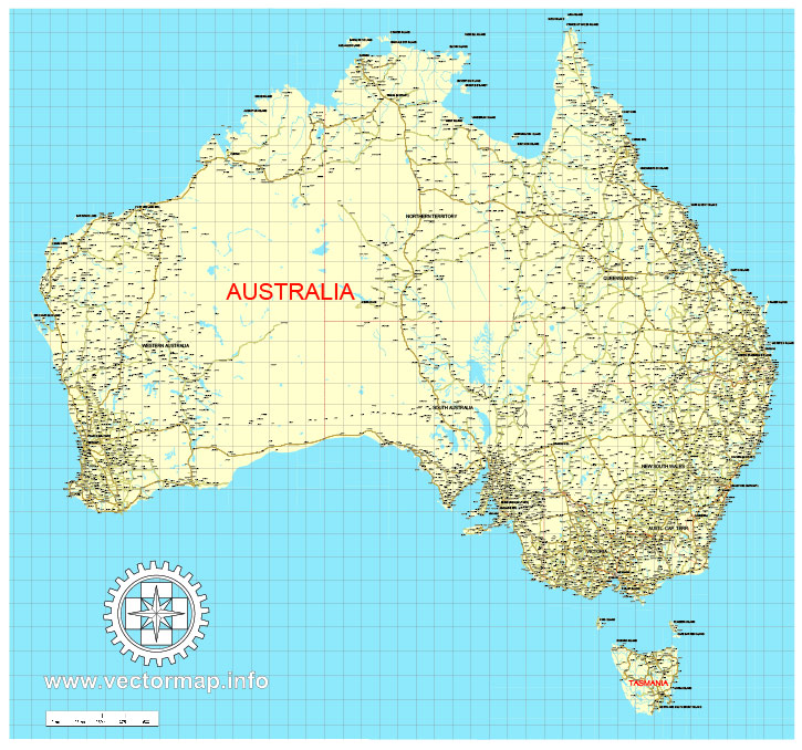
See more Australia Cities vector maps for printing and design
For example: Printable map of Melbourne, Australia
Printable map Cairns, Australia
Printable Map Bendigo, Australia, exact vector street map
Printable Map Albury + Wodonga, Australia

 Author: Kirill Shrayber, Ph.D. FRGS
 Street Map editable Adobe Illustrator in layers")
 Street Map editable Adobe Illustrator in layers")