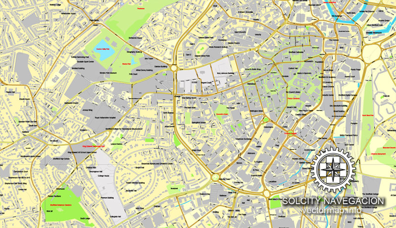
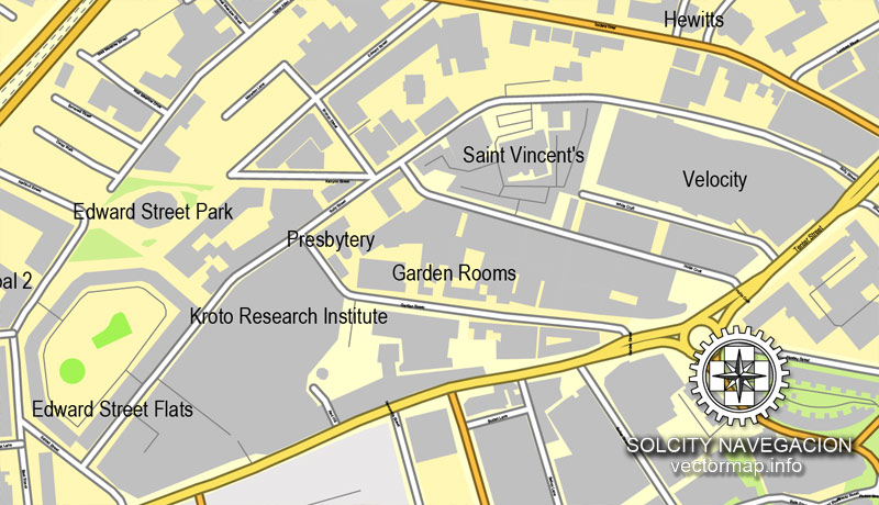
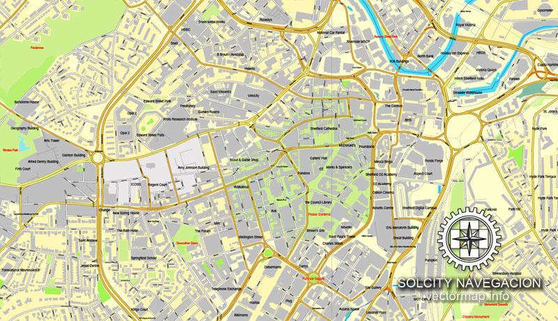
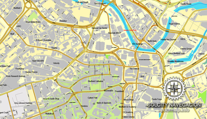
Sheffield, UK Great Britain, printable vector street City Plan map, full editable, Adobe Illustrator, full vector, scalable, editable, text format street names, 12,9 mb ZIP
All streets, All buildings. Map for design, print, arts, projects, presentations.
PDF, DXF, CDR and other formats – on request, same price, please, contact
Sheffield, England.
This vector map of Sheffield is used as a basis for design, editing, and further printing.
This is the most detailed, exact map of Sheffield for high-quality printing and polygraphy. You can always clarify the map development date by contacting us.
For your convenience, all objects on Sheffield vector map are divided into layers. And the editing is very easy – colors, lines, etc.
You can easily add any objects needed (e.g. shops, salons, sale points, gas station or attraction) on any layer of Sheffield vector map.
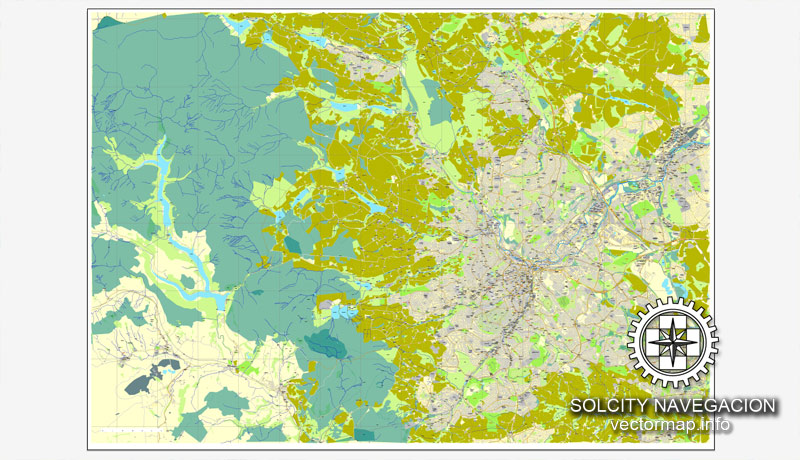
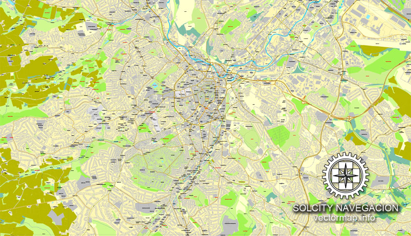
Sheffield is a city and metropolitan borough in South Yorkshire, England. Historically part of the West Riding of Yorkshire, its name derives from the River Sheaf, which runs through the city. With some of its southern suburbs annexed from Derbyshire, the city has grown from its largely industrial roots to encompass a wider economic base. The population of the City of Sheffield is 577,800 (mid-2017 est.) and it is one of the eight largest regional English cities that make up the Core Cities Group. Sheffield is the third-largest English district by population. The metropolitan population of Sheffield is 1,569,000.
One of the advantages of Sheffield vector maps of our production is the relevance of cartographic data, we constantly update all our products.
This vector map of Sheffield is used by:
designers, layout designers, printers, advertisers and architects. Our product – vector maps – is designed for further editing and printing in large formats – from @Wall format (a few meters) to A-0 and A-1, A-2, A-3.
Sheffield map in vector format is used for design, urban planning, presentations and media visualizations.
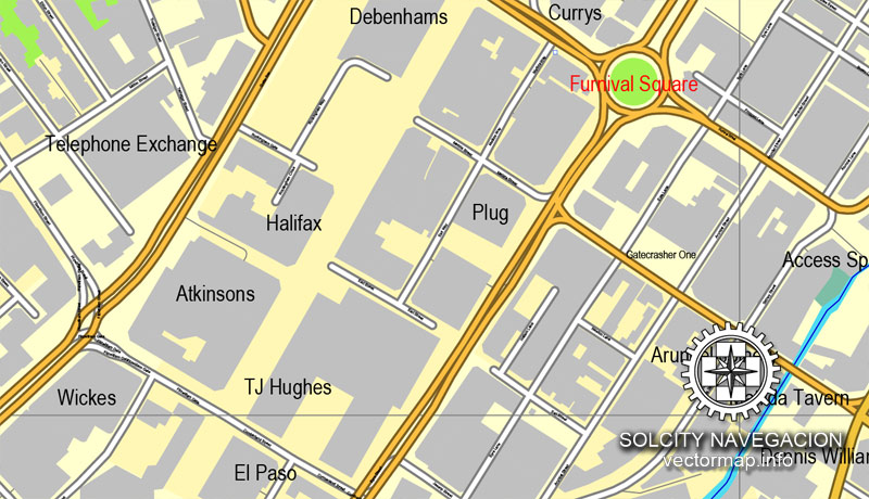
Advertising and presentation map of Sheffield (usually the final designer marks the routes, and puts the client’s objects (shops, saloons, gas stations etc.)
The undoubted advantage is that people will NEVER throw out this advertising product – the map. In fact, as an advertising medium, a map is the most “long-playing” of the well-known polygraphic advertising media, with the longest lifespan, and the maximum number of interactions with the customer.
For travelers, maps are sold at the airports and gas stations around the world. Often the source is our vector maps.
Take a look, who purchases our vector maps of Sheffield in “Our Clients and Friends” page – these are large and small companies, from super-brands like Volvo and Starbucks, to small design studios and printing houses.
It’s very easy to work with vector maps of Sheffield, even for a not very experienced designer who can turn on and off the map layers, add new objects, change the colors of fill and lines according to customer requirements.
The undoubted advantage of Sheffield vector maps in printing is an excellent and detailed visualization, when customer can expand a large paper map and instantly define his location, find a landmark, an object or address on map, unlike using the popular electronic formats of Google and Yandex maps for example.
Printable vector maps of Sheffield are much more convenient and efficient than any electronic maps on your smartphone, because ALL DETAILS are displayed in the entire space of Sheffield map.
Useful tips on working with vector maps of cities and countries in Adobe Illustrator.
«V» – launches the Selection tool (cursor, black arrow), which makes active any vector line.
«А» – launches the Direct Selection tool (white cursor), allows you to select curve elements and drag them to the desired place.
«R» – activates the Rotate tool, which helps you rotating selected objects around the center point by 360 degrees.
«E» – gives you the opportunity to use the Eraser tool and erase unnecessary parts.
«X» – switches between Fill and Stroke in the Tools section. Try to get used to this hot key and
you will quickly understand that you can’t live and work without it.
Guides are not limited to vertical and horizontal in Adobe Illustrator. You can also create a diagonal guide for example. Moreover, you can turn any contours into guides. Select the outline and go to View > Guides > Make Guides (Create Guides), or simply press Cmd/Ctrl + 5. You can also turn the guides back into an editable object. Go to menu, View > Guides > Unlock Guides (Release Guides), select the guide you want to edit and select View > Guides > Release Guides (Reset Guides), or just press Cmd/Ctrl + Option / Alt + 5).
You will probably want to change the color scheme used on our Sheffield vector map.
To quickly and effectively play with colors.
Of course, you can do it manually, all objects in our Sheffield vector map are divided according to types and layers, and you can easily change the color gamma of vector objects in groups and layers.
But there is more effective way of working with the whole VECTOR MAP of Sheffield and all layers:
The overview dialog «Edit colors»/«Repaint Graphic Object» (this dialog box name can change depending on the context):
If you have selected a part or a layer of Sheffield vector map and open the dialog box by clicking the icon in the Control panel, on the Samples palette or the Color Catalog, or if you choose Edit > Edit Colors> Repaint Graphic Object, then the «Repaint Graphic Object» dialog box appears, and you get access to «Assign» and «Edit» tabs.
If a picture or a map fragment is not selected, and you open the dialog box by clicking the icon in the Control panel, on the Samples palette or in the Color Catalog, the «Edit Colors» dialog box appears and you can only access the «Edit» tab.
Regardless of the name at the top of the dialog box, the right-hand side always displays the color group of the current document, as well as two default color groups: Print Color and Grayscale. These color groups can be selected and used any time.
The city is in the eastern foothills of the Pennines, and the valleys of the River Don and its four tributaries, the Loxley, the Porter Brook, the Rivelin and the Sheaf. Sixty-one percent of Sheffield’s entire area is green space, and a third of the city lies within the Peak District national park. There are more than 250 parks, woodlands and gardens in the city, which is estimated to contain around 4.5 million trees.
Create and edit color groups of Sheffield vector map, and also assign colors using the «Edit Colors»/ а «Repaint Graphic Object» dialog box.
A. Creating and editing of a color group on the «Edit» tab
B. Assigning colors on the «Assign» tab
C. Select a group of colors from the «Color groups» list
The option «Repaint a graphic object» in the lower part of the dialog box allows you to preview the colors on a selected layer of Vector map, or a group of elements, and specify whether its colors will be redefined when the dialog box is closed.
The main areas of the dialog box are:
«Edit»
The «Edit» tab is designed to create a new or edit the existing color groups.
The harmony rules Menu and the Color Wheel are used to conduct experiments with color harmonies. The color wheel shows how colors are related in color harmony, and the color bars allow you to view and manipulate an individual color values. In addition, you can adjust the brightness, add and remove colors, save color groups and view colors on the selected Vector Map of Sheffield or a separated layers.
«Assign»
The «Assign» tab is used to view and control on how the original colors are replaced with colors from the color group like your corporate colors in the Vector Map of Sheffield.
The assign color ability is provided only if the entire map, layer or fragment is selected in the document. You can specify which of new colors replace the current colors, whether the spot colors should be preserved and how colors are replaced (for example, you can replace colors completely or changing the color tone while maintaining the brightness). The «Assign» tab allows you to redefine colors in the Vector Map of Sheffield, or in separate layers and fragments using the current color group or reducing the number of colors in the current Vector Map.
Color groups
Is a list of all saved color groups for current document (the same groups appear in the «Samples» palette). You can edit and delete the existing color groups, as well as creating a new ones using the list of “Color Groups” in the dialog box. All changes appear in the «Samples» palette.
The highlighted color group shows, which color group is currently edited.
Any color group can be selected and edited, or used to redefine the colors in the selected vector map of Sheffield, its fragments or elements.
Saving a color group adds this group to the specified list.
Opening the «Edit Colors»/«Repaint Graphic Object» dialog box.
Open the «Edit Colors»/«Repaint Graphic Object» dialog box using one of the following methods:
«Edit»> «Edit Colors»> «Repaint Graphic object» or «Repaint With Style».
Use these commands if you need to edit the colors in the selected vector map of Sheffield.
«Repaint Graphic object» button on the «Control» panel.
Use this button if you need to adjust colors of Sheffield vector map using the а «Repaint graphic object» dialog box.
The specified button is available if the selected vector map or its fragment contains two or more colors.
In the 19th century, Sheffield gained an international reputation for steel production. Known as the Steel City, many innovations were developed locally, including crucible and stainless steel, fuelling an almost tenfold increase in the population in the Industrial Revolution. Sheffield received its municipal charter in 1843, becoming the City of Sheffield in 1893. International competition in iron and steel caused a decline in these industries in the 1970s and 1980s, coinciding with the collapse of coal mining in the area.
Note. This color editing method is convenient for global color adjustment in a vector map, if global colors were not used when creating a Map of Sheffield.
The «Edit colors» button or «Edit or apply colors» on the «Color Catalog» palette
Click this button if you need to edit colors on the «Color Catalog» palette or edit and then apply them to the selected Vector Map of Sheffield or its fragment.
The «Edit color group» button or «Edit or apply color group» on the «Samples» palette.
Click this button if you need to edit the colors in the specific color group or edit and apply them to the selected Vector Map of Sheffield or a group of its elements, for example, the whole layer “Streets and lines”. You can also double-click the color group in the Samples panel to open the dialog box.
If the map file is too large and your computer freezes or even can’t open it quickly:
1. Try to reduce the color resolution of the video card (display) to 256 colors while working with a large map.
2. Using Windows Task Manager, select all the application you don’t need, while working with map, just turn them off.
3. Launch Adobe Illustrator. (DO NOT OPEN the vector map file)
4. Start the Windows Task Manager using administrator rights > Find the “Illustrator” process > set the «real time» priority,
5. Open the file. When you see the LEGACY FONT popup window – click “OK” (do not update). You can restore the TEXT later.
6. Can also be useful: When file is opened – Edit > Settings > Basic Settings > disable smoothing. /// It looks scary, but works quickly)))
We recommend saving the file in Adobe Illustrator 10 version. It’s much more stable when working with VERY BIG size files.
The 21st century has seen extensive redevelopment in Sheffield, along with other British cities. Sheffield’s gross value added (GVA) has increased by 60% since 1997, standing at £9.2 billion in 2007. The economy has experienced steady growth averaging around 5% annually, greater than that of the broader region of Yorkshire and the Humber.
The city has a long sporting heritage, and is home to the world’s oldest football club, Sheffield F.C. Games between the two professional clubs, Sheffield United and Sheffield Wednesday, are known as the Steel City derby. The city is also home to the World Snooker Championship and the Sheffield Steelers, the UK’s first fully professional Ice Hockey team.
Sheffield is located at 53°23′N 1°28′W. It lies directly beside Rotherham, from which it is separated largely by the M1 motorway. Although Barnsley Metropolitan Borough also borders Sheffield to the north, the town itself is a few miles further away. The southern and western borders of the city are shared with Derbyshire; in the first half of the 20th century Sheffield extended its borders south into Derbyshire, annexing a number of villages, including Totley, Dore and the area now known as Mosborough Townships. Directly to the west of the city are the Peak District National Park and the Pennine upland range, while the lowlands of the South Yorkshire Coalfield lie to the east.
Sheffield is a geographically diverse city. The city nestles in the eastern foothills of the Pennines, and a natural amphitheatre created by several hills and the confluence of five rivers: Don, Sheaf, Rivelin, Loxley and Porter. As such, much of the city is built on hillsides with views into the city centre or out to the countryside. Blake Street, in the S6 postcode area, is the third steepest residential street in England, with a gradient of 16.6°. The city’s lowest point is just 29 metres (95 ft) above sea level near Blackburn Meadows, while some parts of the city are at over 500 metres (1,640 ft); the highest point being 548 metres (1,798 ft) at High Stones, near Margery Hill. However, 79% of the housing in the city is between 100 and 200 metres (330 and 660 ft) above sea level.
Estimated to contain around 4.5 million trees, Sheffield has more trees per person than any other city in Europe, and according to Sheffield City Council, it is England’s greenest city, a claim that was reinforced when it won the 2005 Entente Florale competition. With more than 250 parks, woodlands and gardens, it has over 170 woodlands (covering 10.91 sq mi or 28.3 km2), 78 public parks (covering 7.07 sq mi or 18.3 km2) and 10 public gardens. Added to the 52.0 square miles (134.7 km2) of national park and 4.20 square miles (10.9 km2) of water this means that 61% of the city is greenspace. Despite this, about 64% of Sheffield householders live further than 300 metres (328 yd) from their nearest greenspace, although access is better in less affluent neighbourhoods across the city. Sheffield also has a very wide variety of habitat, comparing favourably with any city in the United Kingdom: urban, parkland and woodland, agricultural and arable land, moors, meadows and freshwater-based habitats. There are six areas within the city that are designated as sites of special scientific interest.
The present city boundaries were set in 1974 (with slight modification in 1994), when the former county borough of Sheffield merged with Stocksbridge Urban District and two parishes from the Wortley Rural District. This area includes a significant part of the countryside surrounding the main urban region. Roughly a third of Sheffield lies in the Peak District National Park. No other English city had parts of a national park within its boundary, until the creation in March 2010 of the South Downs National Park, part of which lies within Brighton and Hove.
Small guide: How to work with the vector map?
You can: Mass select objects by type and color – for example, the objects type “building” (they are usually dark gray) – and remove them from the map, if you do not need them in your print or design project. You can also easily change the thickness of lines (streets), just bulk selection the road by the line color.
The streets are separated by type, for example, type “residential road” are usually white with a gray stroke. Highway usually orange with a brown or dark gray stroke.
It is easy to change the font of inscriptions, all or each individually. Also, just can be make and any other manipulation of objects on the vector map in Adobe illustrator format.
Important: All the proportions on the map are true, that is, the relative sizes of the objects are true, because Map is based on an accurate GPS projection, and It transated into the (usual for all) the Mercator projection.
You can easily change the color, stroke and fill of any object on the map, zoom without loss of quality Image Verification.
Select object

Bulk selection the same objects on the vector map

See the bulk selected objects on the vector map

Bulk delete buildungs from the vector map

Select residencial road (small street) on the vector map

Bulk selection the same lines (streets, roads) on the full map

Create fat lines of the streets on the vector maps (bulk action) 1

Create fat lines of the streets on the vector maps (bulk action) 2

Create fat lines of the streets on the vector maps (bulk action) 3

You can easily change the color, stroke and fill of any object on the map, zoom without loss of quality Image Verification.

 Author: Kirill Shrayber, Ph.D. FRGS
