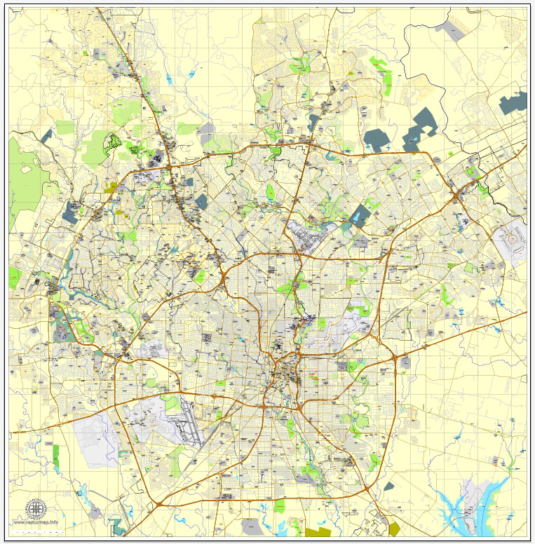
San Antonio, Texas, PDF Map, US, vector street City Plan map, fully editable, Adobe PDF, V3.10, full vector, scalable, editable, text format of street names, 40 Mb ZIP.
All streets, primary buildings. Map for design, print, arts, projects, presentations.
PDF, DXF, CDR and other formats – on request, same price, please, contact.
You can edit this file in Adobe Illustrator, Adobe Acrobat, Corel Draw.
San Antonio, Texas, USA.
This vector map of San Antonio is used as a basis for design, editing, and further printing.
This is the most detailed, exact map of San Antonio for high-quality printing and polygraphy. You can always clarify the map development date by contacting us.
For your convenience, all objects on San Antonio vector map are divided into layers. And the editing is very easy – colors, lines, etc.
You can easily add any objects needed (e.g. shops, salons, sale points, gas station or attraction) on any layer of San Antonio vector map.
San Antonio, officially the City of San Antonio, is the seventh most populous city in the United States, and the second most populous city in both Texas and the Southern United States, home to over 1.5 million people. Founded as a Spanish mission and colonial outpost in 1718, the city became the first chartered civil settlement in Texas in 1731, making it the state’s oldest municipality.
One of the advantages of San Antonio vector maps of our production is the relevance of cartographic data, we constantly update all our products.
This vector map of San Antonio is used by:
designers, layout designers, printers, advertisers and architects. Our product – vector maps – is designed for further editing and printing in large formats – from @Wall format (a few meters) to A-0 and A-1, A-2, A-3.
San Antonio map in vector format is used for design, urban planning, presentations and media visualizations.
Advertising and presentation map of San Antonio (usually the final designer marks the routes, and puts the client’s objects (shops, saloons, gas stations etc.)
The undoubted advantage is that people will NEVER throw out this advertising product – the map. In fact, as an advertising medium, a map is the most “long-playing” of the well-known polygraphic advertising media, with the longest lifespan, and the maximum number of interactions with the customer.
For travelers, maps are sold at the airports and gas stations around the world. Often the source is our vector maps.
Take a look, who purchases our vector maps of San Antonio in “Our Clients and Friends” page – these are large and small companies, from super-brands like Volvo and Starbucks, to small design studios and printing houses.
It’s very easy to work with vector maps of San Antonio, even for a not very experienced designer who can turn on and off the map layers, add new objects, change the colors of fill and lines according to customer requirements.
The undoubted advantage of San Antonio vector maps in printing is an excellent and detailed visualization, when customer can expand a large paper map and instantly define his location, find a landmark, an object or address on map, unlike using the popular electronic formats of Google and Yandex maps for example.
Printable vector maps of San Antonio are much more convenient and efficient than any electronic maps on your smartphone, because ALL DETAILS are displayed in the entire space of San Antonio map.
Useful tips on working with vector maps of cities and countries in Adobe Illustrator.
«V» – launches the Selection tool (cursor, black arrow), which makes active any vector line.
«А» – launches the Direct Selection tool (white cursor), allows you to select curve elements and drag them to the desired place.
«R» – activates the Rotate tool, which helps you rotating selected objects around the center point by 360 degrees.
«E» – gives you the opportunity to use the Eraser tool and erase unnecessary parts.
«X» – switches between Fill and Stroke in the Tools section. Try to get used to this hot key and
you will quickly understand that you can’t live and work without it.
Guides are not limited to vertical and horizontal in Adobe Illustrator. You can also create a diagonal guide for example. Moreover, you can turn any contours into guides. Select the outline and go to View > Guides > Make Guides (Create Guides), or simply press Cmd/Ctrl + 5. You can also turn the guides back into an editable object. Go to menu, View > Guides > Unlock Guides (Release Guides), select the guide you want to edit and select View > Guides > Release Guides (Reset Guides), or just press Cmd/Ctrl + Option / Alt + 5).
You will probably want to change the color scheme used on our San Antonio vector map.
To quickly and effectively play with colors.
Of course, you can do it manually, all objects in our San Antonio vector map are divided according to types and layers, and you can easily change the color gamma of vector objects in groups and layers.
But there is more effective way of working with the whole VECTOR MAP of San Antonio and all layers:
The overview dialog «Edit colors»/«Repaint Graphic Object» (this dialog box name can change depending on the context):
If you have selected a part or a layer of San Antonio vector map and open the dialog box by clicking the icon in the Control panel, on the Samples palette or the Color Catalog, or if you choose Edit > Edit Colors> Repaint Graphic Object, then the «Repaint Graphic Object» dialog box appears, and you get access to «Assign» and «Edit» tabs.
If a picture or a map fragment is not selected, and you open the dialog box by clicking the icon in the Control panel, on the Samples palette or in the Color Catalog, the «Edit Colors» dialog box appears and you can only access the «Edit» tab.
Regardless of the name at the top of the dialog box, the right-hand side always displays the color group of the current document, as well as two default color groups: Print Color and Grayscale. These color groups can be selected and used any time.
Create and edit color groups of San Antonio vector map, and also assign colors using the «Edit Colors»/ а «Repaint Graphic Object» dialog box.
A. Creating and editing of a color group on the «Edit» tab
B. Assigning colors on the «Assign» tab
C. Select a group of colors from the «Color groups» list
The option «Repaint a graphic object» in the lower part of the dialog box allows you to preview the colors on a selected layer of Vector map, or a group of elements, and specify whether its colors will be redefined when the dialog box is closed.
The main areas of the dialog box are:
«Edit»
The «Edit» tab is designed to create a new or edit the existing color groups.
The harmony rules Menu and the Color Wheel are used to conduct experiments with color harmonies. The color wheel shows how colors are related in color harmony, and the color bars allow you to view and manipulate an individual color values. In addition, you can adjust the brightness, add and remove colors, save color groups and view colors on the selected Vector Map of San Antonio or a separated layers.
«Assign»
The «Assign» tab is used to view and control on how the original colors are replaced with colors from the color group like your corporate colors in the Vector Map of San Antonio.
The assign color ability is provided only if the entire map, layer or fragment is selected in the document. You can specify which of new colors replace the current colors, whether the spot colors should be preserved and how colors are replaced (for example, you can replace colors completely or changing the color tone while maintaining the brightness). The «Assign» tab allows you to redefine colors in the Vector Map of San Antonio, or in separate layers and fragments using the current color group or reducing the number of colors in the current Vector Map.
Color groups
Is a list of all saved color groups for current document (the same groups appear in the «Samples» palette). You can edit and delete the existing color groups, as well as creating a new ones using the list of “Color Groups” in the dialog box. All changes appear in the «Samples» palette.
The highlighted color group shows, which color group is currently edited.
Any color group can be selected and edited, or used to redefine the colors in the selected vector map of San Antonio , its fragments or elements.
Saving a color group adds this group to the specified list.
Opening the «Edit Colors»/«Repaint Graphic Object» dialog box.
Open the «Edit Colors»/«Repaint Graphic Object» dialog box using one of the following methods:
«Edit»> «Edit Colors»> «Repaint Graphic object» or «Repaint With Style».
Use these commands if you need to edit the colors in the selected vector map of San Antonio city.
«Repaint Graphic object» button on the «Control» panel.
Use this button if you need to adjust colors of San Antonio vector map using the а «Repaint graphic object» dialog box.
The specified button is available if the selected vector map or its fragment contains two or more colors.
Note. This color editing method is convenient for global color adjustment in a vector map, if global colors were not used when creating a Map of San Antonio.
The «Edit colors» button or «Edit or apply colors» on the «Color Catalog» palette
Click this button if you need to edit colors on the «Color Catalog» palette or edit and then apply them to the selected Vector Map of San Antonio or its fragment.
The «Edit color group» button or «Edit or apply color group» on the «Samples» palette.
Click this button if you need to edit the colors in the specific color group or edit and apply them to the selected Vector Map of San Antonio or a group of its elements, for example, the whole layer “Streets and lines”. You can also double-click the color group in the Samples panel to open the dialog box.
If the map file is too large and your computer freezes or even can’t open it quickly:
1. Try to reduce the color resolution of the video card (display) to 256 colors while working with a large map.
2. Using Windows Task Manager, select all the application you don’t need, while working with map, just turn them off.
3. Launch Adobe Illustrator. (DO NOT OPEN the vector map file)
4. Start the Windows Task Manager using administrator rights > Find the “Illustrator” process > set the «real time» priority,
5. Open the file. When you see the LEGACY FONT popup window – click “OK” (do not update). You can restore the TEXT later.
6. Can also be useful: When file is opened – Edit > Settings > Basic Settings > disable smoothing. /// It looks scary, but works quickly)))
We recommend saving the file in Adobe Illustrator 10 version. It’s much more stable when working with VERY BIG size files.
The city’s deep history is contrasted with its rapid growth: it was the fastest-growing of the top ten largest cities in the United States from 2000 to 2010, and the second from 1990 to 2000. Straddling the regional divide between South and Central Texas, San Antonio anchors the southwestern corner of an urban megaregion colloquially known as the “Texas Triangle”.
San Antonio serves as the seat of Bexar County; recent annexations have extended the city’s boundaries into Medina County and, for a tiny area near the city of Garden Ridge, into Comal County. Since San Antonio was founded during the Spanish Colonial Era, it has a church (San Fernando Cathedral) in its center, on the main civic plaza in front, a characteristic of many Spanish-founded cities, towns, and villages in Spain and Latin America. As with many other urban centers in the Southwestern United States, areas outside the city limits are sparsely populated.
San Antonio is the center of the San Antonio–New Braunfels metropolitan statistical area. Commonly called Greater San Antonio, the metro area has a population of 2,473,974 based on the 2017 U.S. census estimate, making it the 24th-largest metropolitan area in the United States and third-largest in Texas.
Growth along the Interstate 35 and Interstate 10 corridors to the north, west and east make it likely that the metropolitan area will continue to expand.
San Antonio was named by a 1691 Spanish expedition for Saint Anthony of Padua, whose feast day is June 13. The city contains five 18th-century Spanish frontier missions, including The Alamo and San Antonio Missions National Historical Park, which together were designated UNESCO World Heritage sites in 2015. Other notable attractions include the River Walk, the Tower of the Americas, SeaWorld, the Alamo Bowl, and Marriage Island. Commercial entertainment includes Six Flags Fiesta Texas and Morgan’s Wonderland amusement parks. According to the San Antonio Convention and Visitors Bureau, the city is visited by about 32 million tourists a year.
It is home to the five-time NBA champion San Antonio Spurs, and hosts the annual San Antonio Stock Show & Rodeo, one of the largest such events in the U.S.
The U.S. Armed Forces have numerous facilities in and around San Antonio; Fort Sam Houston is the only one within the city limits. Lackland Air Force Base, Randolph Air Force Base, Lackland AFB/Kelly Field Annex, Camp Bullis, and Camp Stanley are outside the city limits.
Kelly Air Force Base operated out of San Antonio until 2001, when the airfield was transferred to Lackland AFB. The remaining parts of the base were developed as Port San Antonio, an industrial/business park and aerospace complex. San Antonio is home to six Fortune 500 companies and the South Texas Medical Center, the only medical research and care provider in the South Texas region.
Geography
San Antonio is approximately 75 miles (121 km) to the southwest of its neighboring city, Austin, the state capital, about 190 miles (310 km) west of Houston, and about 250 miles (400 km) south of the Dallas–Fort Worth area.
The city has a total area of 465.4 square miles (1,205.4 km2)—460.93 square miles (1,193.8 km2) of which is land and 4.5 square miles (11.7 km2) of water.
The city was built on forested land and it sits on the Balcones Escarpment.
Its altitude is 650 feet (198 m) above sea level.
The city’s primary source of drinking water is the Edwards Aquifer. Impounded in 1962 and 1969, respectively, Victor Braunig Lake and Calaveras Lake were among the first reservoirs in the country built to use recycled treated wastewater for power plant cooling, reducing the amount of groundwater needed for electrical generation.
Neighborhoods
Downtown San Antonio, the city and metro area’s urban core, encompasses many of the city’s famous structures, attractions, and businesses. The central business district is generally understood to cover the northern half of the “Downtown Loop”— the area bordered by Cesar Chavez to the south.
Due to the size of the city and its horizontal development, downtown accounts for less than one half of one percent of San Antonio’s geographic area.
North Central
North Central is home to several enclaves and upscale neighborhoods including Castle Hills, Hollywood Park, Elm Creek, Inwood, and Rogers Ranch.
The area is also the location of upper-middle class neighborhoods (Deerfield, Churchill Estates, Hunter’s Creek, Oak Meadow, and Summerfield).
Northwest Side
Northwest Side is the location of the main campus of the University of Texas at San Antonio, the University of Texas Health Science Center at San Antonio, and the Northwest Campus of the University of the Incarnate Word, which includes the Rosenberg School of Optometry. The Medical Center District is also located in Northwest Side. Companies with headquarters in the area include Valero and NuStar Energy.
South Side
The South Side area of San Antonio is characterized for its predominantly Latino and Hispanic neighborhoods, an average above 81 percent.
East Side San Antonio is home to the San Antonio Stock Show & Rodeo, the AT&T Center, and the Freeman Coliseum. The area has the largest concentration of black residents.
West Side
The West Side is predominantly Hispanic and working class, with pockets of wealth in the northwest and far west. It includes the diverse neighborhoods of Avenida Guadalupe, Collins Garden, Las Palmas, Prospect Hill, San Juan Gardens, Loma Park, Loma Vista, Memorial Heights, and Westwood. It is also home to the historic Our Lady of the Lake University and St. Mary’s University.
Free vector maps:

Free download Vector Map US Interstate roads, Adobe PDF, V.2 Free_Map_US_Interstates_Roads_2.pdf
Free download Vector Map US Interstate roads, Adobe Illustrator, V.2 Free_Map_US_Interstates_Roads_2.ai

Free Download Vector Map US County and State Adobe Illustrator
Free_Vector_Map_US_States_County_Map.ai
Free Download Vector Map US County and State Adobe PDF
Free_Vector_Map_US_States_County_Map.pdf

Free Vector Map US Census Data Top US Ancestries by County Adobe Illustrator
Free_Vector_Map_US_Census-Data-Top-US-Ancestries-by-County.ai
Free Vector Map US Census Data Top US Ancestries by County Adobe PDF
Free_Vector_Map_US_Census-Data-Top-US-Ancestries-by-County.pdf
Small guide: How to work with the vector map?
You can: Mass select objects by type and color – for example, the objects type “building” (they are usually dark gray) – and remove them from the map, if you do not need them in your print or design project. You can also easily change the thickness of lines (streets), just bulk selection the road by the line color.
The streets are separated by type, for example, type “residential road” are usually white with a gray stroke. Highway usually orange with a brown or dark gray stroke.
It is easy to change the font of inscriptions, all or each individually. Also, just can be make and any other manipulation of objects on the vector map in Adobe illustrator format.
Important: All the proportions on the map are true, that is, the relative sizes of the objects are true, because Map is based on an accurate GPS projection, and It transated into the (usual for all) the Mercator projection.
You can easily change the color, stroke and fill of any object on the map, zoom without loss of quality Image Verification.
Select object

Bulk selection the same objects on the vector map

See the bulk selected objects on the vector map

Bulk delete buildungs from the vector map

Select residencial road (small street) on the vector map

Bulk selection the same lines (streets, roads) on the full map

Create fat lines of the streets on the vector maps (bulk action) 1

Create fat lines of the streets on the vector maps (bulk action) 2

Create fat lines of the streets on the vector maps (bulk action) 3

You can easily change the color, stroke and fill of any object on the map, zoom without loss of quality Image Verification.
San Antonio, officially the City of San Antonio, is the seventh-most populated city in the United States and the second-most populous city in the state of Texas, with a population of 1,409,019. It was the fastest growing of the top 10 largest cities in the United States from 2000 to 2010, and the second from 1990 to 2000. The city straddles South Texas and Central Texas and is on the southwestern corner of an urban megaregion known as the Texas Triangle.
San Antonio serves as the seat of Bexar County. Recent annexations have extended the city’s boundaries into Medina County and, though for only a very tiny area near the city of Garden Ridge, into Comal County. The city has characteristics of other western urban centers in which there are sparsely populated areas and a low density rate outside of the city limits. San Antonio is the center of the San Antonio–New Braunfels Metropolitan Statistical Area. Commonly referred to as Greater San Antonio, the metropolitan area has a population of nearly 2.4 million based on the 2015 US Census estimate, making it the 25th-largest metropolitan area in the United States and third-largest in the state of Texas. Growth along the Interstate 35 and Interstate 10 corridors to the north, west and east make it likely that the metropolitan area will continue to expand.
Geography of San Antonio
San Antonio is located near 29.5°N 98.5°W. It is about 75 miles to the southwest of its neighboring city, Austin, the state capital. The city is also about 190 miles west of Houston and about 250 miles south of the Dallas–Fort Worth area. According to the U.S. Census Bureau, in 2000 the city had a total area of 412.07 square miles (1,067.3 km2)—407.56 square miles (1,055.6 km2) (98.9%) of land and 4.51 square miles (11.7 km2) (1.1%) of water. The city sits on the Balcones Escarpment. The altitude of San Antonio is 772 feet (235 m) above sea level.
The primary source of drinking water for the city is the Edwards Aquifer. Impounded in 1962 and 1969, respectively, Victor Braunig Lake and Calaveras Lake were among the first reservoirs in the country built to use recycled treated wastewater for power plant cooling, reducing the amount of groundwater needed for electrical generation.

 Author: Kirill Shrayber, Ph.D. FRGS

