Extended Description of the Vector Map
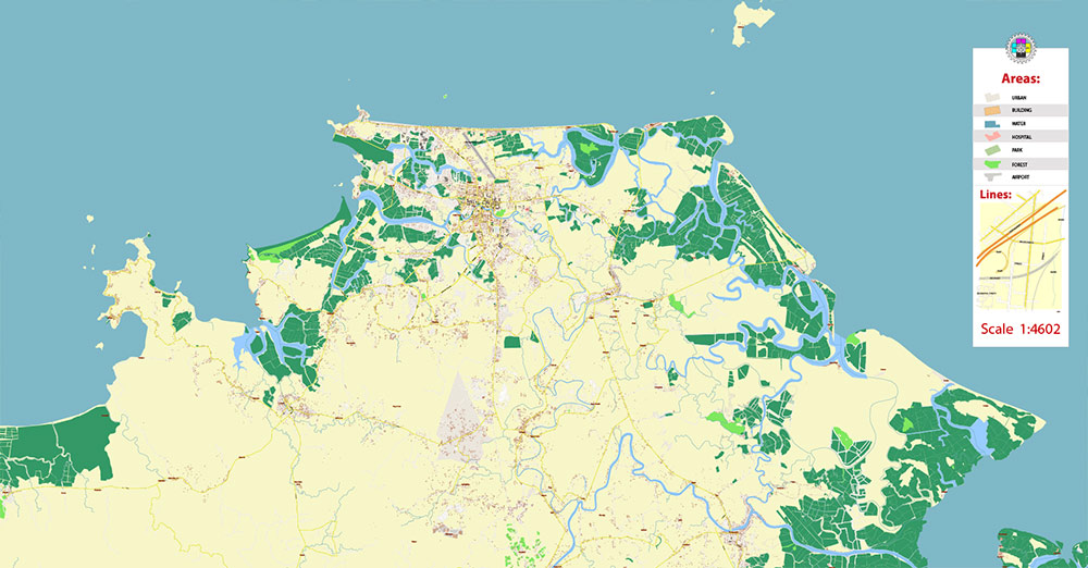
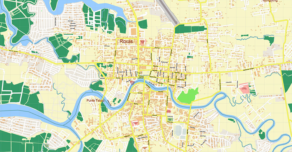
Printable PDF Vector Map of Roxas City Philippines detailed street map scale 1:4602 full editable Adobe PDF scalable, text all names, 12 MB ZIP
All street names, Main Objects, Buildings. Map for design, printing, arts, projects, presentations, for architects, designers, and builders, business, logistics.
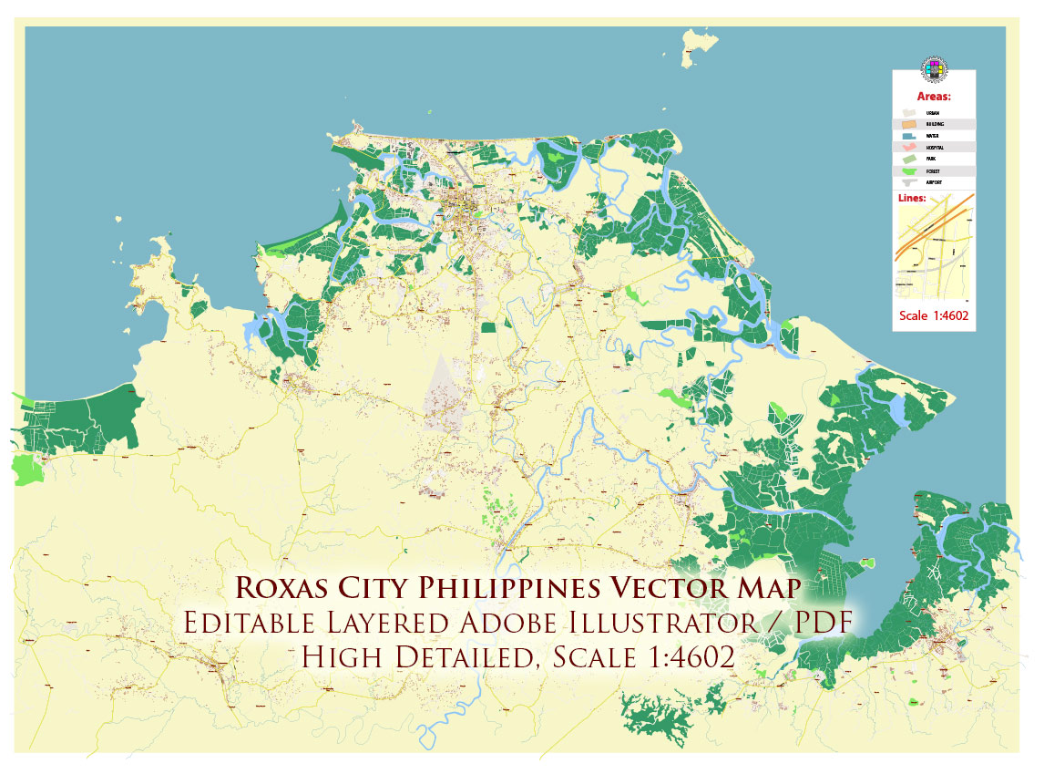
Roxas City Philippines PDF Map Vector Exact City Plan High Detailed Street Map editable Adobe PDF in layers
Layers list:
- Legend and scale
- Grids
- Labels of roads
- Names of places (city, hamlet, etc.)
- Names of objects (parks, water, Hospitals)
- Names of main streets
- Names of residential streets
- Arrows of streets
- Main Streets, roads
- Residential streets
- Buildings
- Airports and Heliports
- Water objects (rivers, lakes, ponds)
- Waterways
- Color fills (parks, hospital areas, land use, etc.)
- Islands
- Background and sea
The most exact and detailed map of the city in scale.
For Editing and High-Quality Printing
AO BRIEF — ROXAS CITY (VECTOR MAP / STREET HIERARCHY VERSION)
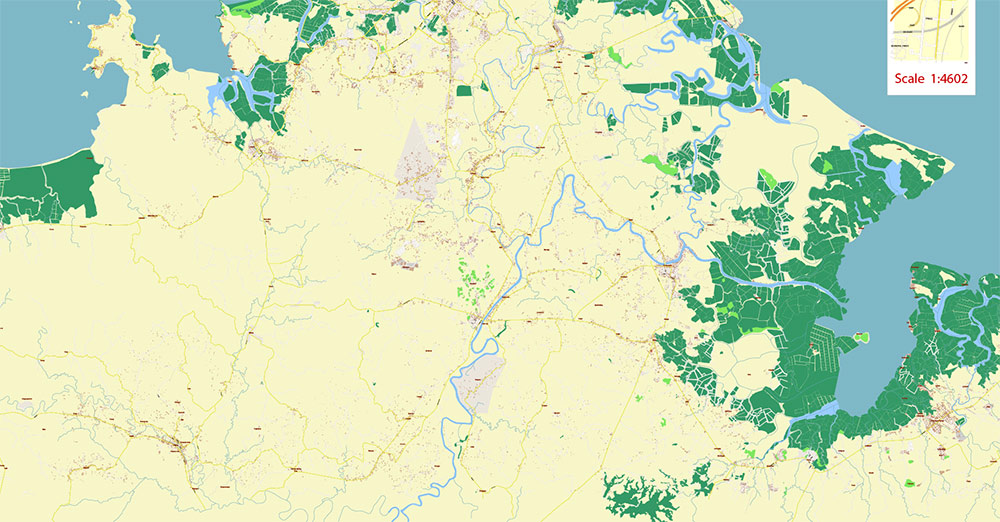
1. URBAN STRUCTURE (FOR CARTOGRAPHIC LAYERING)
- Core type: compact coastal city with rectangular grid center
- Expansion pattern:
- South and southeast — residential spread
- West (Baybay/Culasi) — coastal + port + tourism strip
- Key zones:
- CBD / Downtown: around Rizal Street + Roxas Avenue
- Port/Fishery zone: Culasi – Baybay coastline
- Airport zone: northeast sector (separate node)
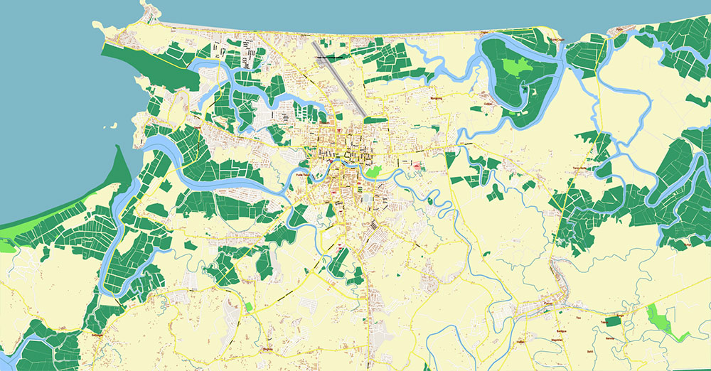
2. PRIMARY ROAD NETWORK (LEVEL 1 — ARTERIALS)
Use as top hierarchy (thick stroke / main routes):
- Roxas Avenue
→ Main urban spine, connects core to outer districts
- Rizal Street
→ Central commercial axis (CBD backbone)
- Arnaldo Boulevard (Baybay axis)
→ Coastal arterial linking downtown with Baybay/Culasi
- Roxas City – Iloilo Road (southbound highway)
→ Primary external خروج corridor (label as regional highway)
- Panay Circumferential Road (Pan-Philippine context)
→ Island-scale route (important for map context layer)
- Airport Road / Roxas Airport Access Road
→ Dedicated connector to airport node
3. SECONDARY NETWORK (LEVEL 2 — DISTRIBUTORS)
Use as medium stroke / urban connectors:
- Sacred Heart of Jesus Avenue
→ Links inner city to coastal and peripheral zones
- Pueblo de Panay roads (planned grid area)
→ Newer structured development, cleaner geometry
- Capiz Bridge approaches (Panay River crossing)
→ Critical crossing point → must be clearly marked
- Inner connectors between Rizal St / Roxas Ave / Arnaldo Blvd
→ Dense grid, short blocks
4. LOCAL NETWORK (LEVEL 3 — RESIDENTIAL / BARANGAY ROADS)
Use as thin stroke:
- Irregular secondary streets outside core grid
- Narrow streets in:
- Culasi
- Baybay coastal strip
- Peripheral barangays
- Expect:
- Non-uniform geometry
- Frequent dead-ends near fishpond zones
5. CRITICAL INFRASTRUCTURE (POINT FEATURES)
Mark clearly (icon layer):
- Roxas Airport (northeast AO)
- Culasi Port / Fish Landing Areas
- Capiz Bridge (major river crossing)
- Public Market (CBD)
- Provincial Capitol / admin zone
6. WATER & COASTAL FEATURES (IMPORTANT FOR GEOMETRY)
- Panay River (major feature)
→ Split city, requires accurate banks + bridge
- Coastal line (Sibuyan Sea)
→ Irregular, with fishpond fragmentation
- Fishpond grids
→ Key visual pattern → rectangular water parcels
- Mangrove zones (patchy, coastal)
7. TRANSPORT LOGIC (FOR MAP INTERPRETATION)
- Flow direction:
- Southbound → Iloilo (primary land flow)
- West → Port (export flow)
- Northeast → Airport (air flow)
- Urban mobility:
- Dense short trips (CBD)
- Radial movement toward:
8. CARTOGRAPHIC NOTES (IMPORTANT FOR YOUR STYLE)
- Hierarchy contrast is critical:
- Level 1 roads clearly dominant
- Level 2 supportive grid
- Level 3 minimal clutter
- Water geometry must be clean:
- River width consistent
- Fishponds simplified but preserved as pattern
- Coastal strip (Baybay) = visual anchor
→ combine road + shoreline + tourism strip
- Do NOT over-detail outskirts
→ focus density in central grid
9. COMMAND TAKEAWAYS (MAP PRODUCTION)
- Three-node structure:
→ CBD — Port — Airport
- Single dominant land axis:
→ Iloilo road (southbound)
- Flat terrain → no elevation constraints → clean geometry
- Key visual identity:
→ coastal + fishpond grid + river split
- Best map composition:
→ center slightly shifted inland to include:
- full CBD
- port
- airport in one frame

Roxas City Philippines PDF Map Vector Exact City Plan High Detailed Street Map editable Adobe PDF in layers
Roxas City Philippines PDF Map Vector Exact City Plan High Detailed Street Map editable Adobe PDF in layers
Roxas City Philippines PDF Map Vector Exact City Plan High Detailed Street Map editable Adobe PDF in layers
Roxas City Philippines PDF Map Vector Exact City Plan High Detailed Street Map editable Adobe PDF in layers
Roxas City Philippines PDF Map Vector Exact City Plan High Detailed Street Map editable Adobe PDF in layers

 Author: Kirill Shrayber, Ph.D. FRGS


