Extended Description of the Vector Map
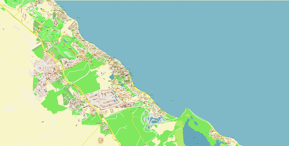
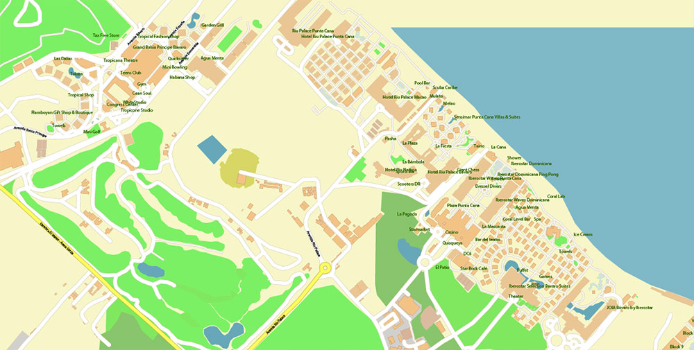
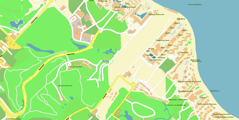
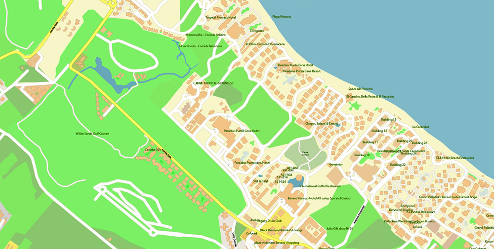
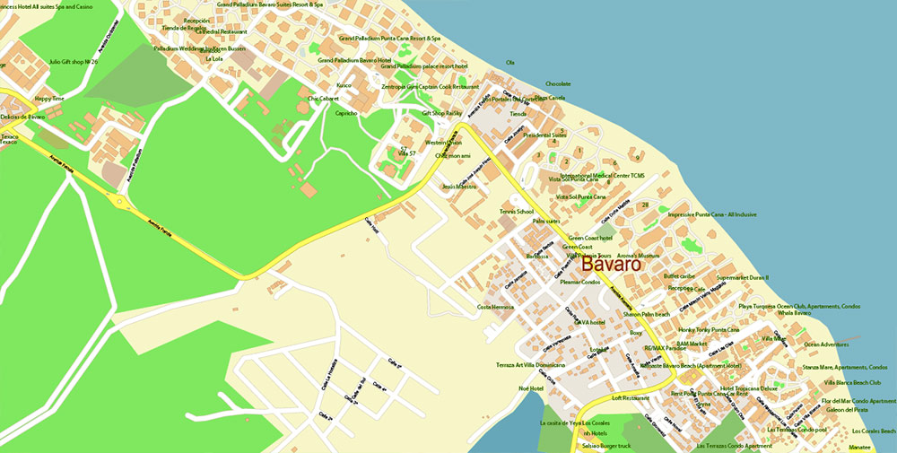
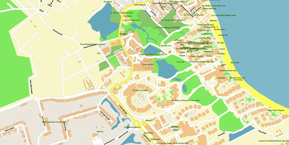
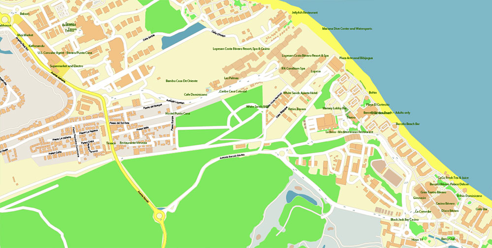
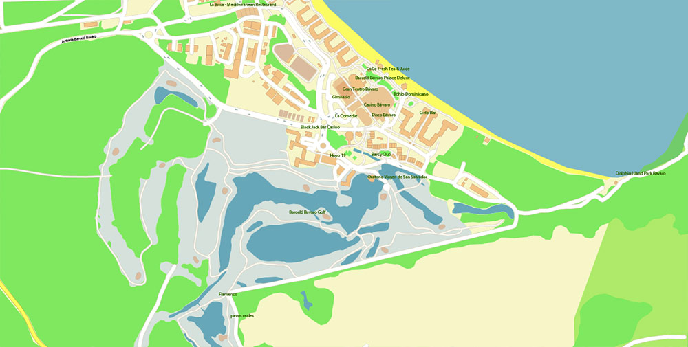
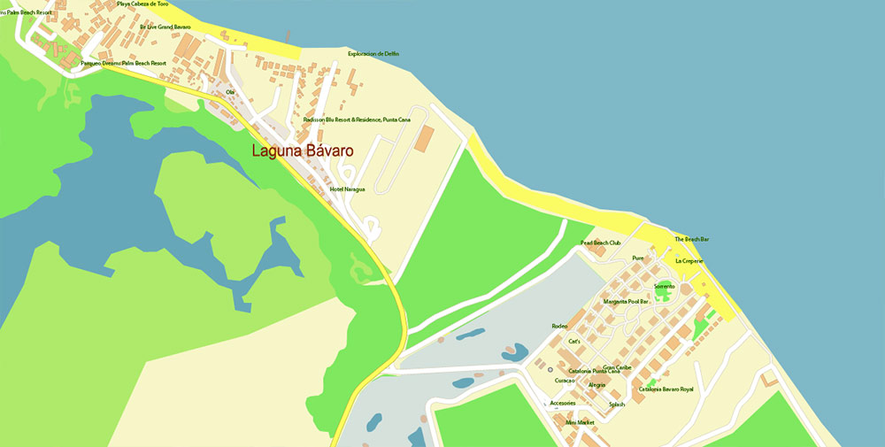
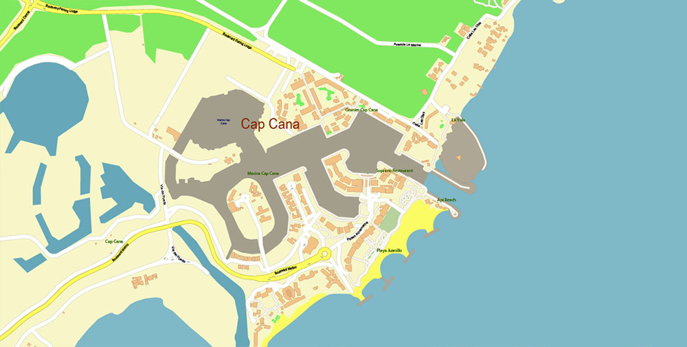
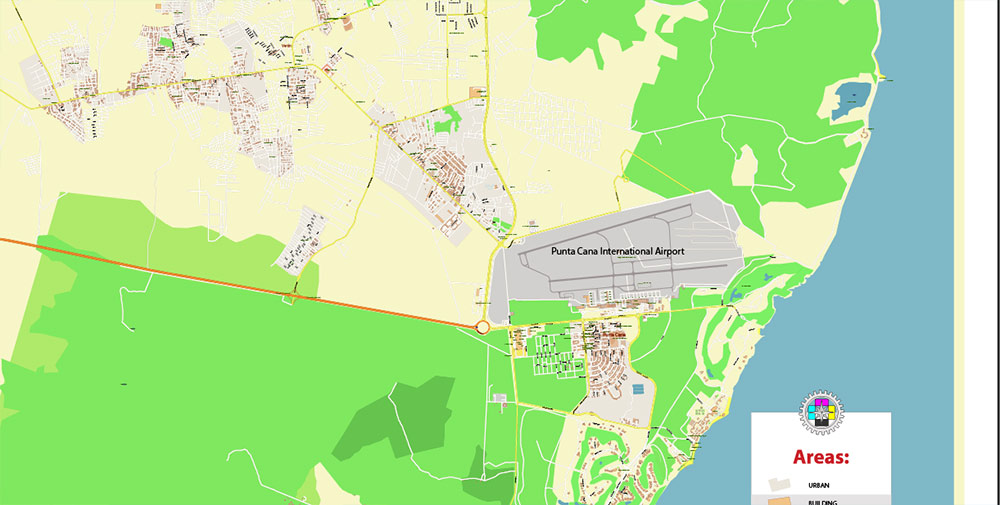
Printable PDF Vector Map of Punta Cana / Bavaro Rep. Dominicana High detailed street map scale 1:4452 fully editable Layered Adobe PDF scalable, text format all names, 13 MB ZIP
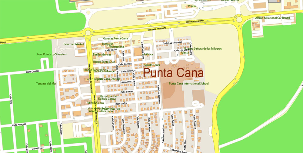
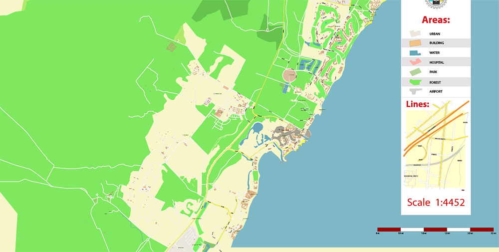
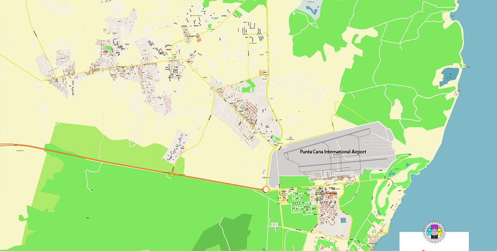
All street names, Main Objects, Buildings. Map for design, printing, arts, projects, presentations, for architects, designers, and builders, business, logistics.
Note: All layers in the preview are enabled and displayed, you may not need all layers – just disable the layers you don’t need.
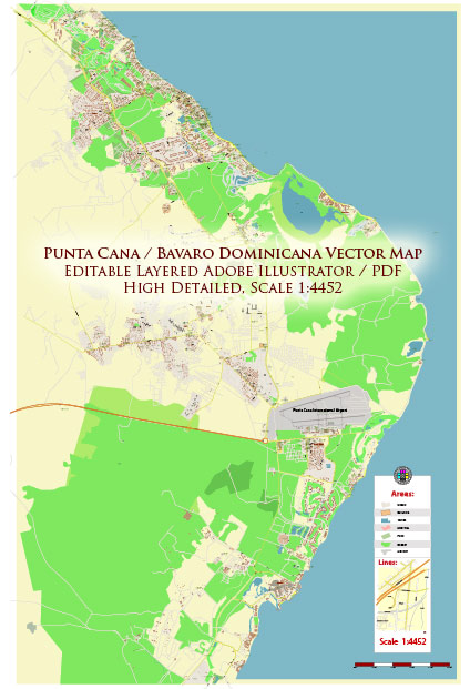
Punta Cana / Bavaro Rep. Dominicana PDF Map Vector Exact City Plan High Detailed Street Map editable Adobe PDF in layers
Layers list:
- Legend
- Labels of roads
- Names of places (city, hamlet, etc.)
- Names of places 2 (Hotels, Restaurants)
- Names of objects (parks, water)
- Names of main streets
- Names of civil streets
- Arrows of streets
- Main Streets, roads
- Residential streets
- Buildings
- Buildings 2 transparent 50%
- Water objects (rivers, lakes, ponds)
- Waterways
- Color fills (parks, land use, etc.)
- Color fills 2 transparent 50%
- Background and Sea
The most exact and detailed map of the city in scale.
For Editing and High-Quality Printing
Punta Cana / Bavaro Rep. Dominicana PDF Map Vector Exact City Plan High Detailed Street Map editable Adobe PDF in layers
PUNTA CANA – BÁVARO AO BRIEF (Dominican Republic)
Theater Overview
-
AO: Eastern tip of Hispaniola, La Altagracia Province. Tourist megacorridor built around Punta Cana–Bávaro beach line; airport-driven economy.
-
Hub: PUJ — Punta Cana International Airport (multi-terminal, heavy charter traffic, VIP/FBO).
-
Terrain: Flat coastal shelf, coral-reef fringe, mangroves/lagoon pockets, scrub inland. Long, continuous beaches; resorts form a near-unbroken wall along the shore.
Primary Lines of Communication (LoCs)
-
Autopista del Coral (DR-3) — Four-lane artery west to La Romana → Santo Domingo; main long-haul logistics spine.
-
Boulevard Turístico del Este — Local lifeline connecting airport, Verón, Punta Cana, and Bávaro; feeds resort service roads.
-
Carretera Verón–Punta Cana — Airport/service access.
-
Avenida Barceló / Avenida Alemania — Bávaro intra-grid (hotels, malls, worker housing).
-
Carretera Arena Gorda / Carretera El Macao — Northern resort belt and beachheads.
-
Cabeza de Toro corridor — East-side resort cluster and marinas.
-
Expect tourist congestion, buses, construction trucks; night driving risk elevated.
Climate & Seasonality (Operational Impact)
-
Tropical maritime: warm-humid year-round (typ. 23–32 °C).
-
Wet phase: May–Nov — fast, heavy downpours; standing water; occasional flooding.
-
Hurricane window: Jun–Nov — air/sea ops degrade rapidly under cyclones.
-
Sea state: Atlantic exposure north/east, Caribbean lee south; surf + rip currents vary with trades.
-
Environmental factors: seasonal sargassum incursions on beaches; mosquitoes (dengue risk).
Human Terrain & Civil Considerations
-
Population: Rapidly grown service workforce; heavy in-migration from elsewhere in DR and Haiti.
-
Language: Spanish dominant; English widely used in resort zones.
-
Security: Tourist police presence (CESTUR) in hotel areas; private resort security standard.
-
Utilities: Grid power can be spotty; many resorts run backup gensets and on-site desalination. Potable water outside resorts inconsistent.
-
Comms: Major mobile carriers present; coverage along the corridor is generally strong.
Tourism Footprint (Key Compounds)
-
Bávaro/Arena Gorda–Macao belt: Hard Rock Hotel & Casino, Iberostar Grand Bávaro, Riu Palace complex, Lopesan Costa Bávaro, Grand Bávaro Princess, Occidental Punta Cana, Majestic resorts.
-
Bávaro–Los Corales/Cortecito: Barceló Bávaro Palace, Paradisus Palma Real, Meliá Caribe/Punta Cana Beach, Secrets Royal Beach, Dreams Royal Beach.
-
South toward Cap Cana/Punta Cana: high-end enclaves and marinas (Hyatt Ziva/Zilara Cap Cana, Eden Roc, Sanctuary, etc.).
-
Compounds are self-contained “micro-cities” with controlled access, internal roads, medical posts, and logistics yards.
Key Terrain & Sites
-
PUJ airfield — critical entry point; high apron turnover, charter peaks.
-
Downtown Punta Cana / BlueMall / San Juan Shopping Center — civilian concentration nodes inland from the beach line.
-
Public beach gates: Cortecito & Los Corales — mixed tourist/local flow.
-
Lagoon/eco areas: Indigenous Eyes (Ojos Indígenas), mangrove patches — soft ground, limited access.
Threats & Hazards
-
Weather: squall lines, lightning, cyclone tracks → divert plans, watch drainage.
-
Traffic: bus/truck mix on Boulevard del Este; night ops require heightened discipline.
-
Littoral: rip currents, reef heads, and boat traffic near marina channels.
-
Health: heat stress, dehydration, insect-borne disease; standard prophylaxis and water discipline.
-
Criminal risk: typically low inside resorts; higher at nightlife pockets and off-corridor settlements—maintain normal tourist-area posture.
Logistics & Sustainment Notes
-
Primary supply in/out: road via DR-3; air via PUJ; sea via Cap Cana/Punta Cana marinas (limited cargo utility).
-
Fuel: road-delivered; resort compounds keep on-site tanks.
-
Medical: several private clinics near resort belt; major definitive care in Higüey/La Romana/Santo Domingo.
Navigation Cues (Quick Reference)
-
Use DR-3 for strategic movement; Boulevard Turístico for all local shuttles.
-
Airport lies south of main beach belt; most resort spurs run north/north-east from the Boulevard.
-
Expect checkpoints/gates at resort entrances; coordinate access in advance.
Command Takeaways
-
The AO is flat, fast, and canalized: one strategic highway, one primary local boulevard, many private spurs.
-
Weather is usually permissive but May–Nov shifts the risk profile (rain, cyclones).
-
Treat resort compounds as semi-closed urban islands along a continuous coastline; deconflict with tourism flow and private security at all times.
Punta Cana / Bavaro Rep. Dominicana PDF Map Vector Exact City Plan High Detailed Street Map editable Adobe PDF in layers
Punta Cana / Bavaro Rep. Dominicana PDF Map Vector Exact City Plan High Detailed Street Map editable Adobe PDF in layers
Punta Cana / Bavaro Rep. Dominicana PDF Map Vector Exact City Plan High Detailed Street Map editable Adobe PDF in layers
Punta Cana / Bavaro Rep. Dominicana PDF Map Vector Exact City Plan High Detailed Street Map editable Adobe PDF in layers
Punta Cana / Bavaro Rep. Dominicana PDF Map Vector Exact City Plan High Detailed Street Map editable Adobe PDF in layers
Punta Cana / Bavaro Rep. Dominicana PDF Map Vector Exact City Plan High Detailed Street Map editable Adobe PDF in layers
Punta Cana / Bavaro Rep. Dominicana PDF Map Vector Exact City Plan High Detailed Street Map editable Adobe PDF in layers
Punta Cana / Bavaro Rep. Dominicana PDF Map Vector Exact City Plan High Detailed Street Map editable Adobe PDF in layers
Punta Cana / Bavaro Rep. Dominicana PDF Map Vector Exact City Plan High Detailed Street Map editable Adobe PDF in layers
Punta Cana / Bavaro Rep. Dominicana PDF Map Vector Exact City Plan High Detailed Street Map editable Adobe PDF in layers
Punta Cana / Bavaro Rep. Dominicana PDF Map Vector Exact City Plan High Detailed Street Map editable Adobe PDF in layers
Punta Cana / Bavaro Rep. Dominicana PDF Map Vector Exact City Plan High Detailed Street Map editable Adobe PDF in layers
Punta Cana / Bavaro Rep. Dominicana PDF Map Vector Exact City Plan High Detailed Street Map editable Adobe PDF in layers

 Author: Kirill Shrayber, Ph.D. FRGS


