Printable Map Portland, Maine, US, exact vector street City Plan map V3.09, full editable, Adobe Illustrator, full vector, scalable, editable text format street names, 4 mb ZIP
All streets, Principal buildings. Map for publishing, design, printing, publications, arts, projects, presentations, for architects, designers and builders, business, logistics. The most exact and detailed map of the city.
Royalty Free.
DXF, DWG, CDR and other formats – on request, same price, please, contact.
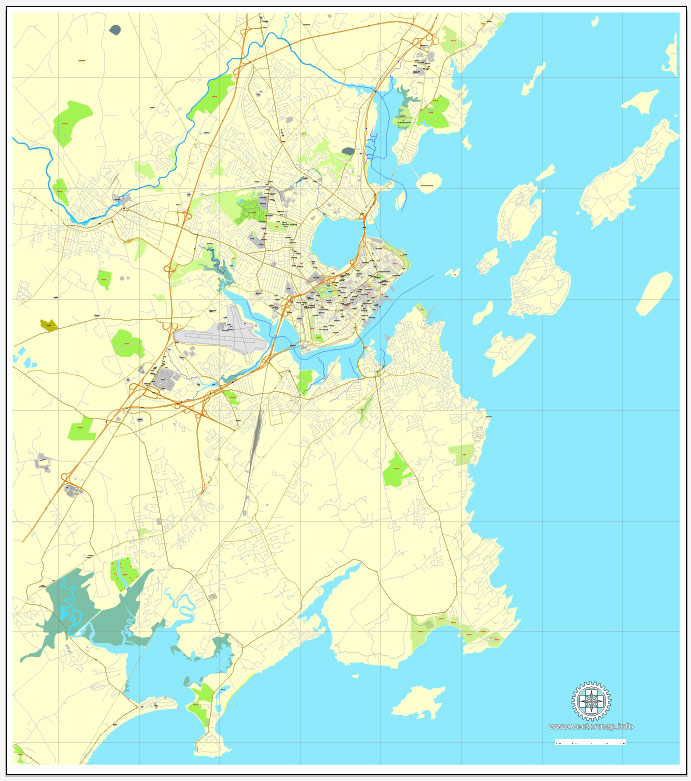
Portland, Maine, USA.
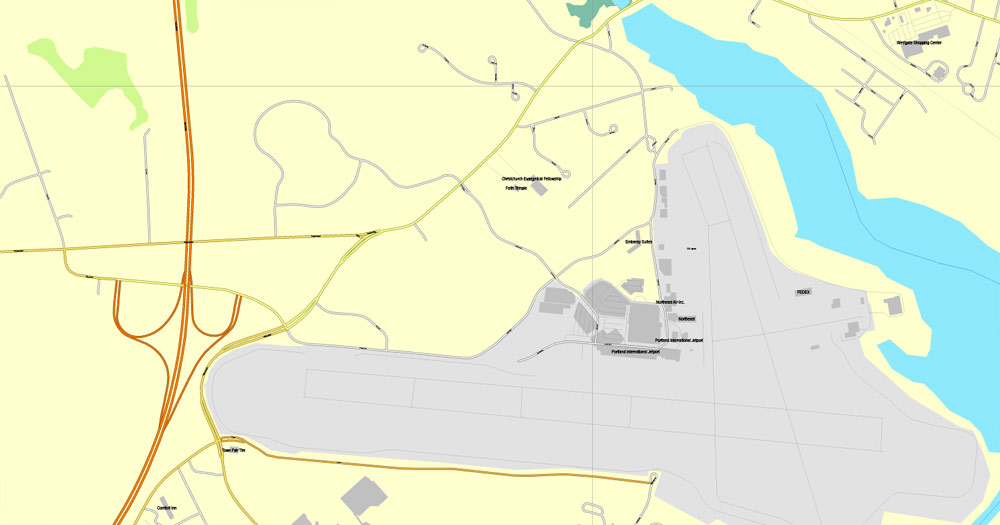
This vector map of Portland is used as a basis for design, editing, and further printing.
This is the most detailed, exact map of Portland for high-quality printing and polygraphy. You can always clarify the map development date by contacting us.
For your convenience, all objects on Portland vector map are divided into layers. And the editing is very easy – colors, lines, etc.
You can easily add any objects needed (e.g. shops, salons, sale points, gas station or attraction) on any layer of Portland vector map.
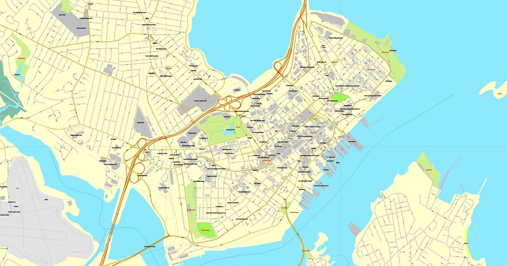
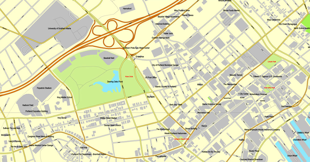
Portland is the most populous city in the U.S. state of Maine, with a population of 67,067 as of 2017. The Greater Portland metropolitan area is home to over half a million people, more than one-third of Maine’s total population, making it the most populous metro in northern New England (an area comprising the states of Maine, New Hampshire, and Vermont). Portland is Maine’s economic center, with an economy that relies on the service sector and tourism. The Old Port district is a popular destination known for its 19th century architecture and nightlife. Marine industry still plays an important role in the city’s economy, with an active waterfront that supports fishing and commercial shipping. The Port of Portland is the largest tonnage seaport in New England.
One of the advantages of Portland vector maps of our production is the relevance of cartographic data, we constantly update all our products.
This vector map of Portland is used by:
designers, layout designers, printers, advertisers and architects. Our product – vector maps – is designed for further editing and printing in large formats – from @Wall format (a few meters) to A-0 and A-1, A-2, A-3.
Portland map in vector format is used for design, urban planning, presentations and media visualizations.
Advertising and presentation map of Portland (usually the final designer marks the routes, and puts the client’s objects (shops, saloons, gas stations etc.)
The undoubted advantage is that people will NEVER throw out this advertising product – the map. In fact, as an advertising medium, a map is the most “long-playing” of the well-known polygraphic advertising media, with the longest lifespan, and the maximum number of interactions with the customer.
For travelers, maps are sold at the airports and gas stations around the world. Often the source is our vector maps.
Take a look, who purchases our vector maps of Portland in “Our Clients and Friends” page – these are large and small companies, from super-brands like Volvo and Starbucks, to small design studios and printing houses.
It’s very easy to work with vector maps of Portland, even for a not very experienced designer who can turn on and off the map layers, add new objects, change the colors of fill and lines according to customer requirements.
The undoubted advantage of Portland vector maps in printing is an excellent and detailed visualization, when customer can expand a large paper map and instantly define his location, find a landmark, an object or address on map, unlike using the popular electronic formats of Google and Yandex maps for example.
Printable vector maps of Portland are much more convenient and efficient than any electronic maps on your smartphone, because ALL DETAILS are displayed in the entire space of Portland map.
Useful tips on working with vector maps of cities and countries in Adobe Illustrator.
«V» – launches the Selection tool (cursor, black arrow), which makes active any vector line.
«А» – launches the Direct Selection tool (white cursor), allows you to select curve elements and drag them to the desired place.
«R» – activates the Rotate tool, which helps you rotating selected objects around the center point by 360 degrees.
«E» – gives you the opportunity to use the Eraser tool and erase unnecessary parts.
«X» – switches between Fill and Stroke in the Tools section. Try to get used to this hot key and
you will quickly understand that you can’t live and work without it.
The city has also seen growth in the technology sector, with companies such as WEX building headquarters in the city. The city seal depicts a phoenix rising from ashes, which is a reference to the recoveries from four devastating fires. Portland was named after the English Isle of Portland, Dorset. The city of Portland, Oregon was named after Portland, Maine.
Guides are not limited to vertical and horizontal in Adobe Illustrator. You can also create a diagonal guide for example. Moreover, you can turn any contours into guides. Select the outline and go to View > Guides > Make Guides (Create Guides), or simply press Cmd/Ctrl + 5. You can also turn the guides back into an editable object. Go to menu, View > Guides > Unlock Guides (Release Guides), select the guide you want to edit and select View > Guides > Release Guides (Reset Guides), or just press Cmd/Ctrl + Option / Alt + 5).
You will probably want to change the color scheme used on our Portland vector map.
To quickly and effectively play with colors.
Of course, you can do it manually, all objects in our Portland vector map are divided according to types and layers, and you can easily change the color gamma of vector objects in groups and layers.
But there is more effective way of working with the whole VECTOR MAP of Portland and all layers:
The overview dialog «Edit colors»/«Repaint Graphic Object» (this dialog box name can change depending on the context):
If you have selected a part or a layer of Portland vector map and open the dialog box by clicking the icon in the Control panel, on the Samples palette or the Color Catalog, or if you choose Edit > Edit Colors> Repaint Graphic Object, then the «Repaint Graphic Object» dialog box appears, and you get access to «Assign» and «Edit» tabs.
If a picture or a map fragment is not selected, and you open the dialog box by clicking the icon in the Control panel, on the Samples palette or in the Color Catalog, the «Edit Colors» dialog box appears and you can only access the «Edit» tab.
Regardless of the name at the top of the dialog box, the right-hand side always displays the color group of the current document, as well as two default color groups: Print Color and Grayscale. These color groups can be selected and used any time.
Create and edit color groups of Portland vector map, and also assign colors using the «Edit Colors»/ а «Repaint Graphic Object» dialog box.
A. Creating and editing of a color group on the «Edit» tab
B. Assigning colors on the «Assign» tab
C. Select a group of colors from the «Color groups» list
The option «Repaint a graphic object» in the lower part of the dialog box allows you to preview the colors on a selected layer of Vector map, or a group of elements, and specify whether its colors will be redefined when the dialog box is closed.
The main areas of the dialog box are:
«Edit»
The «Edit» tab is designed to create a new or edit the existing color groups.
The harmony rules Menu and the Color Wheel are used to conduct experiments with color harmonies. The color wheel shows how colors are related in color harmony, and the color bars allow you to view and manipulate an individual color values. In addition, you can adjust the brightness, add and remove colors, save color groups and view colors on the selected Vector Map of Portland or a separated layers.
«Assign»
The «Assign» tab is used to view and control on how the original colors are replaced with colors from the color group like your corporate colors in the Vector Map of Portland.
The assign color ability is provided only if the entire map, layer or fragment is selected in the document. You can specify which of new colors replace the current colors, whether the spot colors should be preserved and how colors are replaced (for example, you can replace colors completely or changing the color tone while maintaining the brightness). The «Assign» tab allows you to redefine colors in the Vector Map of Portland, or in separate layers and fragments using the current color group or reducing the number of colors in the current Vector Map.
Color groups
Is a list of all saved color groups for current document (the same groups appear in the «Samples» palette). You can edit and delete the existing color groups, as well as creating a new ones using the list of “Color Groups” in the dialog box. All changes appear in the «Samples» palette.
The highlighted color group shows, which color group is currently edited.
Any color group can be selected and edited, or used to redefine the colors in the selected vector map of Portland , its fragments or elements.
Saving a color group adds this group to the specified list.
Opening the «Edit Colors»/«Repaint Graphic Object» dialog box.
Open the «Edit Colors»/«Repaint Graphic Object» dialog box using one of the following methods:
«Edit»> «Edit Colors»> «Repaint Graphic object» or «Repaint With Style».
Use these commands if you need to edit the colors in the selected vector map of Portland.
«Repaint Graphic object» button on the «Control» panel.
Use this button if you need to adjust colors of Portland vector map using the а «Repaint graphic object» dialog box.
The specified button is available if the selected vector map or its fragment contains two or more colors.
Note. This color editing method is convenient for global color adjustment in a vector map, if global colors were not used when creating a Map of Portland.
The «Edit colors» button or «Edit or apply colors» on the «Color Catalog» palette
Click this button if you need to edit colors on the «Color Catalog» palette or edit and then apply them to the selected Vector Map of Portland or its fragment.
The «Edit color group» button or «Edit or apply color group» on the «Samples» palette.
Click this button if you need to edit the colors in the specific color group or edit and apply them to the selected Vector Map of Portland or a group of its elements, for example, the whole layer “Streets and lines”. You can also double-click the color group in the Samples panel to open the dialog box.
If the map file is too large and your computer freezes or even can’t open it quickly:
1. Try to reduce the color resolution of the video card (display) to 256 colors while working with a large map.
2. Using Windows Task Manager, select all the application you don’t need, while working with map, just turn them off.
3. Launch Adobe Illustrator. (DO NOT OPEN the vector map file)
4. Start the Windows Task Manager using administrator rights > Find the “Illustrator” process > set the «real time» priority,
5. Open the file. When you see the LEGACY FONT popup window – click “OK” (do not update). You can restore the TEXT later.
6. Can also be useful: When file is opened – Edit > Settings > Basic Settings > disable smoothing. /// It looks scary, but works quickly)))
We recommend saving the file in Adobe Illustrator 10 version. It’s much more stable when working with VERY BIG size files.
Geography
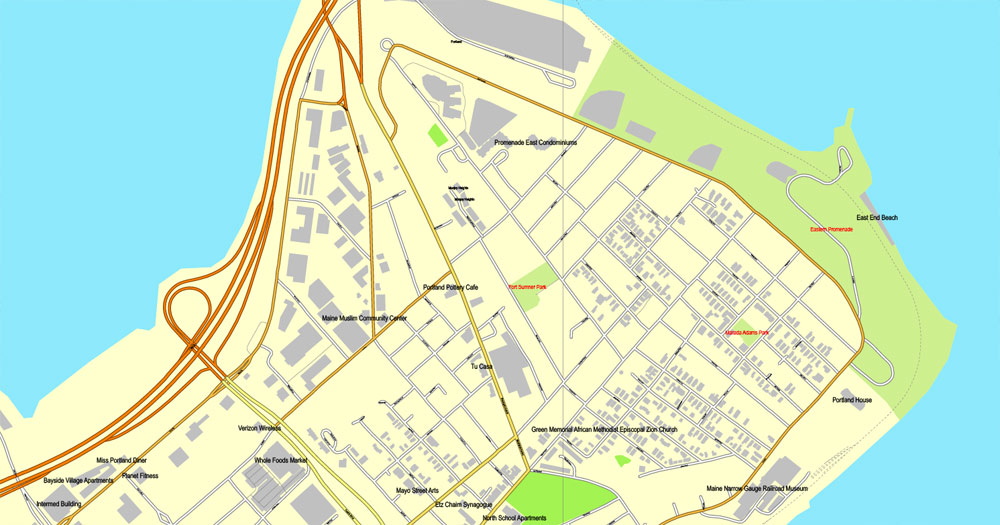
According to the United States Census Bureau, the city has a total area of 69.44 square miles (179.85 km2), of which 21.31 square miles (55.19 km2) is land and 48.13 square miles (124.66 km2) is water. Portland is situated on a peninsula in Casco Bay on the Gulf of Maine and the Atlantic Ocean.
Portland borders South Portland, Westbrook and Falmouth. The city is located at 43.66713 N, 70.20717 W.
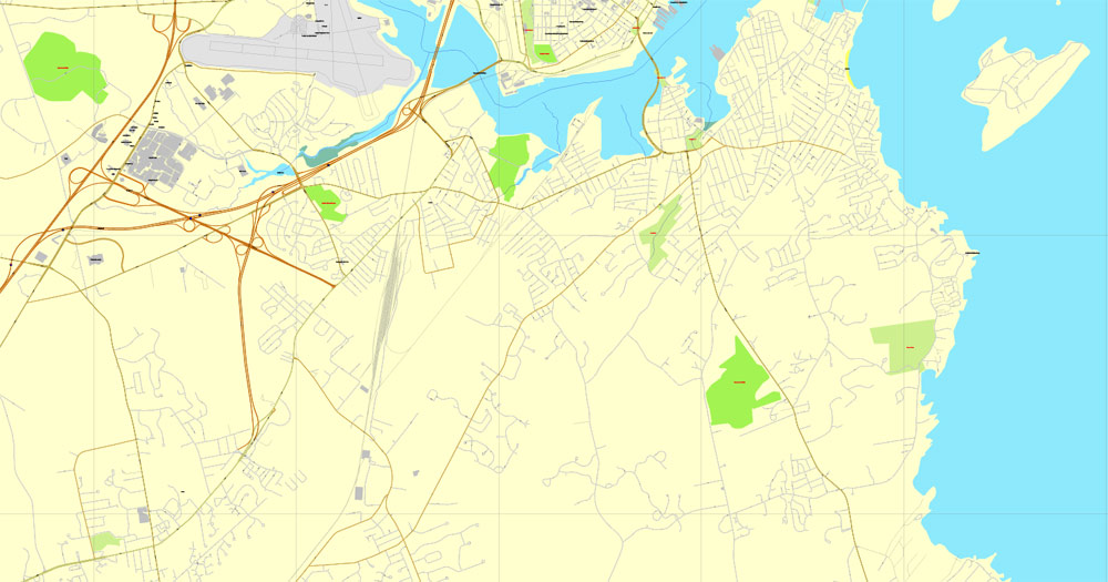
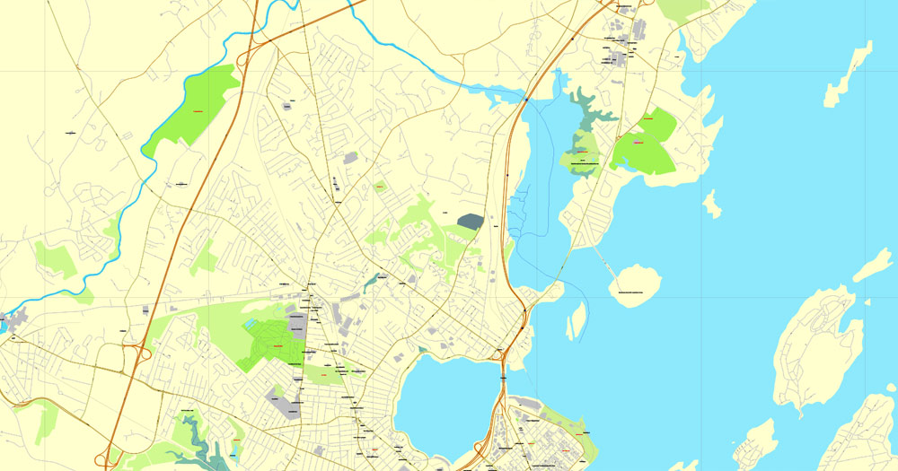
Portland is organized into neighborhoods generally recognized by residents, but they have no legal or political authority. In many cases, city signs identify neighborhoods or intersections (which are often called corners). Most city neighborhoods have a local association which usually maintains ongoing relations of varying degrees with the city government on issues affecting the neighborhood.
On March 8, 1899, Portland annexed the neighboring city of Deering. Deering neighborhoods now comprise the northern and eastern sections of the city before the merger. Portland’s Deering High School was formerly the public high school for Deering.
Portland’s neighborhoods include the Arts District; Bayside; Bradley’s Corner; Cushing’s Island; Deering Center; Deering Highlands; Downtown; East Deering; East Bayside; East End; Eastern Cemetery; Great Diamond Island; Highlands; Kennedy Park; Libbytown; Little Diamond Island; Lunt’s Corner; Morrill’s Corner; Munjoy Hill; Nason’s Corner; North Deering; Oakdale; the Old Port; Parkside; Peaks Island; Riverton Park; Rosemont; Stroudwater; West End; and Woodford’s Corner.

Portland
City in Maine
Portland is a city in the U.S. state of Maine, set on a peninsula extending into Casco Bay. The Old Port waterfront features working fishing wharves and converted warehouses with restaurants and shops. Nearby, the Western Promenade is a public park atop a bluff, offering river and mountain views. Its surrounding district, the West End, is full of Victorian-era homes, including the Victoria Mansion museum.
Population: 66,318
Free vector maps:

Free download Vector Map US Interstate roads, Adobe PDF, V.2 Free_Map_US_Interstates_Roads_2.pdf
Free download Vector Map US Interstate roads, Adobe Illustrator, V.2 Free_Map_US_Interstates_Roads_2.ai

Free Download Vector Map US County and State Adobe Illustrator
Free_Vector_Map_US_States_County_Map.ai
Free Download Vector Map US County and State Adobe PDF
Free_Vector_Map_US_States_County_Map.pdf

Free Vector Map US Census Data Top US Ancestries by County Adobe Illustrator
Free_Vector_Map_US_Census-Data-Top-US-Ancestries-by-County.ai
Free Vector Map US Census Data Top US Ancestries by County Adobe PDF
Free_Vector_Map_US_Census-Data-Top-US-Ancestries-by-County.pdf

 Author: Kirill Shrayber, Ph.D. FRGS

