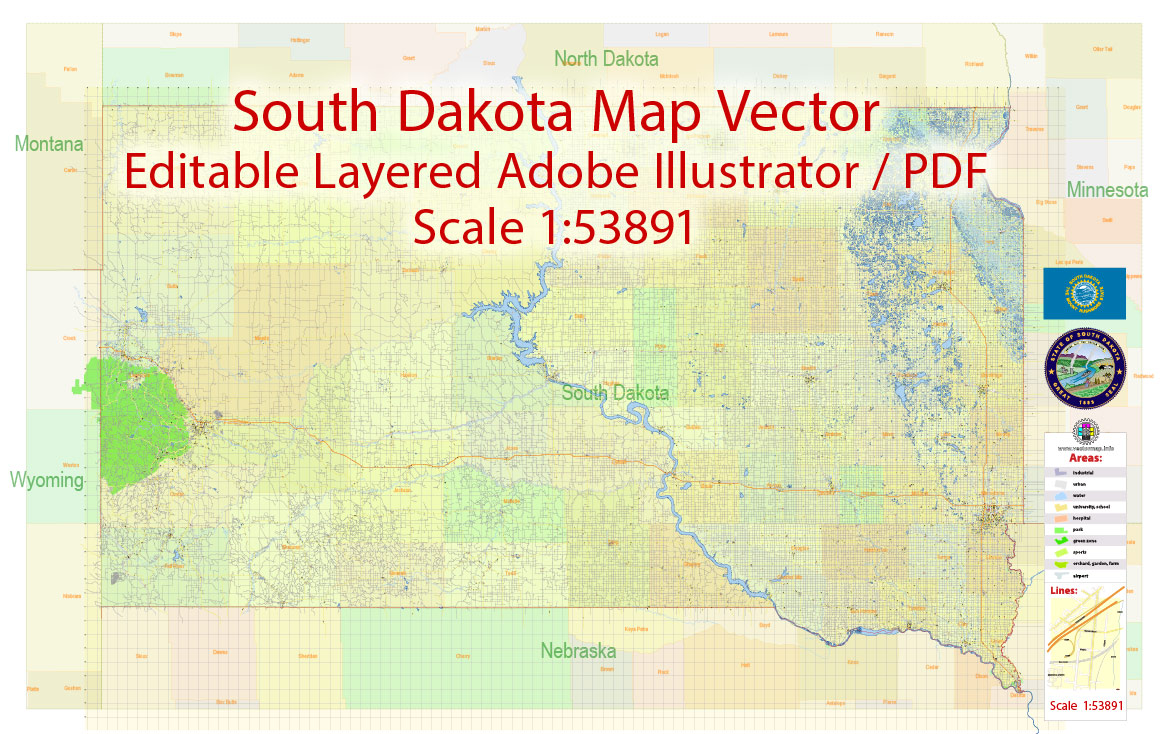
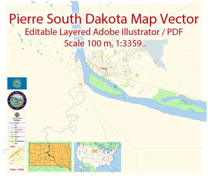
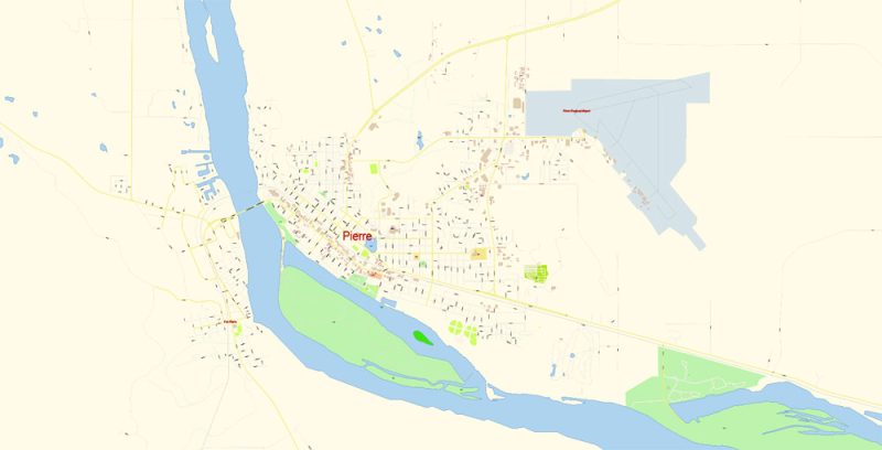
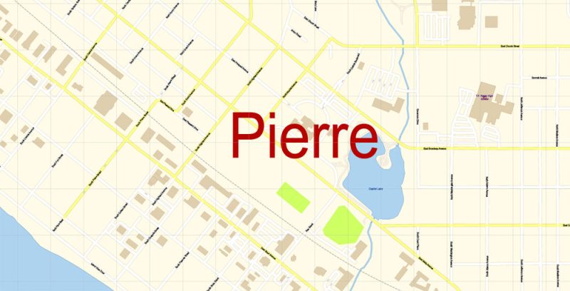
Printable PDF Vector Map of Pierre South Dakota US detailed City Plan scale 100 m 1:3325 full editable Adobe PDF Street Map in layers, scalable, text format all names, 8 MB ZIP
All street names, Main Objects, Principal Buildings. Map for design, printing, arts, projects, presentations, for architects, designers, and builders, business, logistics.
Layers: color_fills, water, streets_roads, labels_roads, names_objects, names_streets, names_places, arrows_streets, buildings, grids, legend, etc.
The most exact and detailed map of the city in scale.
For Editing and High-Quality Printing
Pierre
City in South Dakota
Pierre is the capital of the U.S. state of South Dakota and the seat of Hughes County. The population was 13,646 at the 2010 census, making it the second-least populous state capital in the United States, following only Montpelier, Vermont, and the eighth-most populous city in South Dakota.
Elevation: 443 m
Area: 33.85 km²
Population: 14,004
Urban plan Pierre South Dakota: Digital Cartography
South Dakota is a truly American province, where there are practically no large cities, and the state capital, the city of Pyrrhus, occupies the penultimate place in terms of the number of inhabitants among the administrative centers of American regions. South Dakota, like neighboring North Dakota, got its name from two Indian tribes – Dakota and Lakota, whose representatives still make up a considerable percentage of the state’s population.
In one of the largest natural parks in the state, Custer Park, an annual “buffalo corral” takes place, when anyone can participate in the corral of almost 1,500 bison in the central part of the massif. Unlike the earlier times of the Wild West, it is forbidden to shoot at animals, and the rounding up has become just ordinary fun, a kind of tribute to the past.
South Dakota occupies the territory of the Rocky Mountains, the Great Plains, as well as some parts of the Mississippi River basin, which caused an extremely diverse relief and picturesque counties. The most famous natural massif of the region is the Black Hills, which from time immemorial have been considered shrines for all Indian tribes living on the territory of the Great Plains. Legend has it that this place has a special magical energy, where you can get powers and various abilities.

The capital of the state is the city of Pierre.
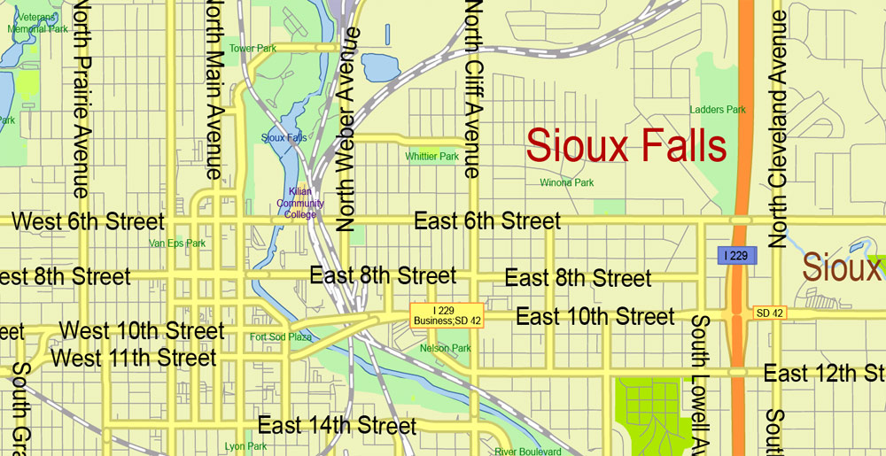
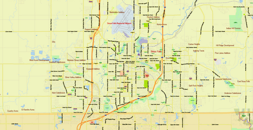
The largest city is Sioux Falls.
How to get
The central city of the state of Pierre can only be reached by air. There is a small airport in the city, where regular commercial flights fly from Denver and Minneapolis, you can fly to these cities from Russia with transfers in London, Frankfurt am Main, Los Angeles or New York.
Black Hills Attractions
On the territory of the mountain range is almost the main popularly recognized curiosity of the Midwest – Mount Rushmore, on which is carved a huge bas-relief depicting the founding fathers of American statehood: the first President George Washington, author of the Declaration of Independence Thomas Jefferson, liberator of Negro slaves Abraham Lincoln and Theodore Roosevelt, a prominent international peacemaker.
Theodore Roosevelt’s head is carved into the rock a little deeper than the heads of other presidents since explosives were used in the construction of the monument and too large a piece of rock was chipped off.
The approach to the mountain begins with the Alley of Flags, along which it is very easy to get to the observation deck, which offers a great view of the mountain. Along the alley, you can walk to the numerous cafes located at the foot. The relief of Rushmore itself is closed for climbing and is guarded by the staff of the complex, although the neighboring rocks are very popular with climbers. Not far from the entrance there are several food outlets and souvenir shops. The entrance to the memorial is free, and you only need to pay for a parking space in the parking lot.
On one of the peaks of the sacred Black Hills, there is another similar memorial, which half a century ago became the largest work of art carved into the rock. The monument is dedicated to the deceased Indian chief Furious Horse, the main fighter for the independence of the Lakota tribes. Construction has been underway since 1948, mainly by enthusiasts. After the completion of the work, the Rampaging Horse will “grow” to a height of 172 meters, almost 10 times the size of the memorial of American presidents on Mount Rushmore.
In the film “Reservation”, the plot of which is imbued with the dream of the cultural independence of the Dakota Indians, a policeman from among the representatives of the tribe in the finale of the film throws a bag of paint on the memorial of the presidents, approaching the mountain from the back. The film caused a wave of indignation and the growth of national liberation sentiments among American Indians.
Motorcycle rally in Sturgis
Every two years, the largest biker race in the world takes place on the territory of South Dakota in the town of Sturgis, which traces its history back to 1938. Surprisingly, then only nine people came to the city, whereas in 2005 the event was attended by more than 600,000 people! In addition to the amazing atmosphere and extremely colorful audience, you can see the world’s leading rock musicians here, many of whom come also as participants.
There is even a bike museum in Sturgis, which presents the history of the development of motorcycle technology, covering the world’s leading manufacturers of “iron horses”.
In addition, the motorcycle show in Sturgis is an excellent representative platform for manufacturers of bikes and components. So, many companies present their new products at this show. And recently, another competition has joined the ranks of festival events, this time among customizers who make motorcycles in the most amazing configurations and images. Over the past few years, one of the main figures of the festival has become a chopper (a motorcycle with an elongated frame and a front fork).
The mysterious Jewel Cave
In South Dakota, there is the second-longest cave in the world, the labyrinths of which stretch for 257 kilometers at a depth of more than 190 meters. It is noteworthy that only one natural entrance leads to the Jewel cave, and strong winds are constantly blowing in the corridors and cavities, sometimes reaching speeds of 15 m/s.
In the center of the cave, there is a second artificial entrance, through which excursions can be conducted on most of the speleological objects. The visit to Jewel is divided into two stages, the first of which is designed to explore the halls closest to the exit. There is no need to have additional equipment and training, and the journey will take a little time. If desired, you can book a tour of the remote labyrinths in the company of a professional speleologist who will tell you about the history of the discovery of each site.
The walls of the cave are almost everywhere covered with calcite, a mineral that, when illuminated, can take on a variety of colors while creating an impressive spectacle. Brothers Frank and Albert Michaud, who discovered the cave in 1900, without thinking twice, called it Jewel Cave, which means “cave of a precious stone”.
Terry Peak Ski Resort
The slope of Terry Peak Mountain is a real paradise for snowboarders and skiers because the length of the route here is 3219 meters with a height difference of almost 351 meters. The ski trails are open from November to April. The resort has two ski lifts, and at the foot of the mountain, there is a service where you can rent houses or sit in a cafe. A snowpark is equipped on the territory of the ski base, where numerous obstacles and trampolines are erected, which allows famous athletes to train here, among others.
Related Images “Urban plan Pierre South Dakota”:
Pierre South Dakota PDF Map Vector Exact City Plan detailed Street Map Adobe PDF in layers
Pierre South Dakota PDF Map Vector Exact City Plan detailed Street Map Adobe PDF in layers

Pierre South Dakota PDF Map Vector Exact City Plan detailed Street Map Adobe PDF in layers
Pierre South Dakota PDF Map Vector Exact City Plan detailed Street Map Adobe PDF in layers


 Author: Kirill Shrayber, Ph.D. FRGS


