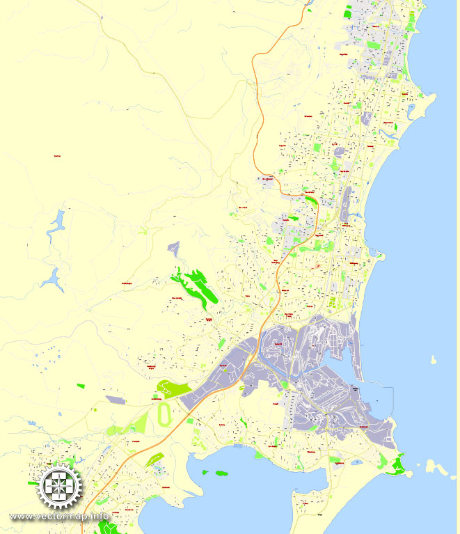
PDF Map Wollongong, Australia, exact vector street map, V27.11, fully editable, Adobe PDF, G-View Level 17 (100 meters scale), full vector, scalable, editable, text format of street names, 6 Mb ZIP.
All streets named, main objects. Map for publishing, design, printing, publications, arts, projects, presentations, for architects, designers and builders, business, logistics. The most exact and detailed map of the city.
Separated layers: streets and roads, color fills, objects, road labels, names 1,2,3, scales.
Royalty Free.
You can edit this file by Adobe Illustrator, Adobe Acrobat, Corel Draw.
DWG, DXF, CDR and other formats – by request, same price, please contact.
Wollongong, New South Wales, Australia.
This vector map of Wollongong is used as a basis for design, editing, and further printing.
This is the most detailed, exact map of Wollongong for high-quality printing and polygraphy. You can always clarify the map development date by contacting us.
For your convenience, all objects on Wollongong vector map are divided into layers. And the editing is very easy – colors, lines, etc.
You can easily add any objects needed (e.g. shops, salons, sale points, gas station or attraction) on any layer of Wollongong vector map.
Wollongong is a seaside city located in the Illawarra region of New South Wales, Australia. Wollongong lies on the narrow coastal strip between the Illawarra Escarpment and the Pacific Ocean, 68 kilometres (51 miles) south of centre of Sydney. Wollongong had an estimated urban population of 299,203 at June 2017, making it the third-largest city in New South Wales after Sydney and Newcastle, and the tenth-largest city in Australia. The city’s current mayor is Gordon Bradbery who was elected in 2018.
One of the advantages of Wollongong vector maps of our production is the relevance of cartographic data, we constantly update all our products.
This vector map of Wollongong is used by:
designers, layout designers, printers, advertisers and architects. Our product – vector maps – is designed for further editing and printing in large formats – from @Wall format (a few meters) to A-0 and A-1, A-2, A-3.
Advertising and presentation map of Wollongong (usually the final designer marks the routes, and puts the client’s objects (shops, saloons, gas stations etc.)
The undoubted advantage is that people will NEVER throw out this advertising product – the map. In fact, as an advertising medium, a map is the most “long-playing” of the well-known polygraphic advertising media, with the longest lifespan, and the maximum number of interactions with the customer.
For travelers, maps are sold at the airports and gas stations around the world. Often the source is our vector maps.
Take a look, who purchases our vector maps of Wollongong in “Our Clients and Friends” page – these are large and small companies, from super-brands like Volvo and Starbucks, to small design studios and printing houses.
It’s very easy to work with vector maps of Wollongong, even for a not very experienced designer who can turn on and off the map layers, add new objects, change the colors of fill and lines according to customer requirements.
The undoubted advantage of Wollongong vector maps in printing is an excellent and detailed visualization, when customer can expand a large paper map and instantly define his location, find a landmark, an object or address on map, unlike using the popular electronic formats of Google and Yandex maps for example.
The Wollongong metropolitan area extends from Helensburgh in the north to Shell Cove in the south. It sits within the Wollongong Statistical District, which covers the local authority areas of Wollongong, Shellharbour and Kiama, extending from the town of Helensburgh in the north, to Gerroa in the south Geologically, the city is located in the south-eastern part of the Sydney basin, which extends from Newcastle to Nowra.
Printable vector maps of Wollongong are much more convenient and efficient than any electronic maps on your smartphone, because ALL DETAILS are displayed in the entire space of Wollongong map.
Useful tips on working with vector maps of cities and countries in Adobe Illustrator.
«V» – launches the Selection tool (cursor, black arrow), which makes active any vector line.
«А» – launches the Direct Selection tool (white cursor), allows you to select curve elements and drag them to the desired place.
«R» – activates the Rotate tool, which helps you rotating selected objects around the center point by 360 degrees.
«E» – gives you the opportunity to use the Eraser tool and erase unnecessary parts.
«X» – switches between Fill and Stroke in the Tools section. Try to get used to this hot key and
you will quickly understand that you can’t live and work without it.
Guides are not limited to vertical and horizontal in Adobe Illustrator. You can also create a diagonal guide for example. Moreover, you can turn any contours into guides. Select the outline and go to View > Guides > Make Guides (Create Guides), or simply press Cmd/Ctrl + 5. You can also turn the guides back into an editable object. Go to menu, View > Guides > Unlock Guides (Release Guides), select the guide you want to edit and select View > Guides > Release Guides (Reset Guides), or just press Cmd/Ctrl + Option / Alt + 5).
You will probably want to change the color scheme used on our Wollongong vector map.
To quickly and effectively play with colors.
Of course, you can do it manually, all objects in our Wollongong vector map are divided according to types and layers, and you can easily change the color gamma of vector objects in groups and layers.
But there is more effective way of working with the whole VECTOR MAP of Wollongong and all layers:
The overview dialog «Edit colors»/«Repaint Graphic Object» (this dialog box name can change depending on the context):
If you have selected a part or a layer of Wollongong vector map and open the dialog box by clicking the icon in the Control panel, on the Samples palette or the Color Catalog, or if you choose Edit > Edit Colors> Repaint Graphic Object, then the «Repaint Graphic Object» dialog box appears, and you get access to «Assign» and «Edit» tabs.
If a picture or a map fragment is not selected, and you open the dialog box by clicking the icon in the Control panel, on the Samples palette or in the Color Catalog, the «Edit Colors» dialog box appears and you can only access the «Edit» tab.
Regardless of the name at the top of the dialog box, the right-hand side always displays the color group of the current document, as well as two default color groups: Print Color and Grayscale. These color groups can be selected and used any time.
Create and edit color groups of Wollongong vector map, and also assign colors using the «Edit Colors»/ а «Repaint Graphic Object» dialog box.
A. Creating and editing of a color group on the «Edit» tab
B. Assigning colors on the «Assign» tab
C. Select a group of colors from the «Color groups» list
The option «Repaint a graphic object» in the lower part of the dialog box allows you to preview the colors on a selected layer of Vector map, or a group of elements, and specify whether its colors will be redefined when the dialog box is closed.
The main areas of the dialog box are:
«Edit»
The «Edit» tab is designed to create a new or edit the existing color groups.
The harmony rules Menu and the Color Wheel are used to conduct experiments with color harmonies. The color wheel shows how colors are related in color harmony, and the color bars allow you to view and manipulate an individual color values. In addition, you can adjust the brightness, add and remove colors, save color groups and view colors on the selected Vector Map of Wollongong or a separated layers.
«Assign»
The «Assign» tab is used to view and control on how the original colors are replaced with colors from the color group like your corporate colors in the Vector Map of Wollongong.
The assign color ability is provided only if the entire map, layer or fragment is selected in the document. You can specify which of new colors replace the current colors, whether the spot colors should be preserved and how colors are replaced (for example, you can replace colors completely or changing the color tone while maintaining the brightness). The «Assign» tab allows you to redefine colors in the Vector Map of Wollongong, or in separate layers and fragments using the current color group or reducing the number of colors in the current Vector Map.
Color groups
Is a list of all saved color groups for current document (the same groups appear in the «Samples» palette). You can edit and delete the existing color groups, as well as creating a new ones using the list of “Color Groups” in the dialog box. All changes appear in the «Samples» palette.
The highlighted color group shows, which color group is currently edited.
Any color group can be selected and edited, or used to redefine the colors in the selected vector map of Wollongong, its fragments or elements.
Saving a color group adds this group to the specified list.
Opening the «Edit Colors»/«Repaint Graphic Object» dialog box.
Open the «Edit Colors»/«Repaint Graphic Object» dialog box using one of the following methods:
«Edit»> «Edit Colors»> «Repaint Graphic object» or «Repaint With Style».
Use these commands if you need to edit the colors in the selected vector map of Wollongong.
«Repaint Graphic object» button on the «Control» panel.
Use this button if you need to adjust colors of Wollongong vector map using the а «Repaint graphic object» dialog box.
The specified button is available if the selected vector map or its fragment contains two or more colors.
Note. This color editing method is convenient for global color adjustment in a vector map, if global colors were not used when creating a Map of Wollongong.
The «Edit colors» button or «Edit or apply colors» on the «Color Catalog» palette
Click this button if you need to edit colors on the «Color Catalog» palette or edit and then apply them to the selected Vector Map of Wollongong or its fragment.
The «Edit color group» button or «Edit or apply color group» on the «Samples» palette.
Click this button if you need to edit the colors in the specific color group or edit and apply them to the selected Vector Map of Wollongong or a group of its elements, for example, the whole layer “Streets and lines”. You can also double-click the color group in the Samples panel to open the dialog box.
If the map file is too large and your computer freezes or even can’t open it quickly:
1. Try to reduce the color resolution of the video card (display) to 256 colors while working with a large map.
2. Using Windows Task Manager, select all the application you don’t need, while working with map, just turn them off.
3. Launch Adobe Illustrator. (DO NOT OPEN the vector map file)
4. Start the Windows Task Manager using administrator rights > Find the “Illustrator” process > set the «real time» priority,
5. Open the file. When you see the LEGACY FONT popup window – click “OK” (do not update). You can restore the TEXT later.
6. Can also be useful: When file is opened – Edit > Settings > Basic Settings > disable smoothing. /// It looks scary, but works quickly)))
We recommend saving the file in Adobe Illustrator 10 version. It’s much more stable when working with VERY BIG size files.
Wollongong is noted for its heavy industry, its port activity and the quality of its physical setting, occupying a narrow coastal plain between an almost continuous chain of surf beaches and the cliffline of the rainforest-covered Illawarra escarpment. It has two cathedrals, churches of many denominations and the Nan Tien Temple, the largest Buddhist temple in the southern hemisphere. Wollongong has a long history of coal mining and industry. The city attracts many tourists each year, and is a regional centre for the South Coast fishing industry. The University of Wollongong has around 37,000 students and is internationally recognised.
The name “Wollongong” is believed to mean “seas of the South” in the local Aboriginal language, referring to NSW’s Southern Coast. Other meanings have been suggested, such as “great feast of fish”, “hard ground near water”, “song of the sea”, “sound of the waves”, “many snakes” and “five islands”.
The city of Wollongong has a distinct geography. It lies on a narrow coastal plain flanked by the Tasman Sea to the east and a steep sandstone precipice known as the Illawarra Escarpment to the west. The coastal plain is widest in the south and narrowest in the north, with the city centre located about midway. South of the city centre but within the urban area is Lake Illawarra, a large lagoon.
The escarpment ranges between 150 and 750 metres (490–2,460 ft) above sea level, with locally famous mountains such as Mount Keira (464m), Mount Kembla (534m), Broker’s Nose (440m) and Mount Murray (768m) to the south. It contains strata of coal measures, and the adit entrances to many coal mines have been established along the slopes of the escarpment throughout Wollongong. Suburbia encroaches on the escarpment’s lower slopes in some areas, but the majority remains in a relatively natural state forested with dry sclerophyll and pockets of temperate rainforest. The escarpment is largely protected by a State Conservation Area and local scenic protection zoning, and provides the visual backdrop to the city.
In the north the escarpment meets the coastline, and north of this the coastal road Lawrence Hargrave Drive hugs the cliff line. The unstable geology of the escarpment resulted in rockfalls, forcing the closure of the road. Subsequently, part of Lawrence Hargrave Drive was replaced in 2005 by the Sea Cliff Bridge just off the coast, crossing the submerged rock shelf. The bridge carries both vehicular and pedestrian traffic. The Illawarra railway line must go through several tunnels to reach the Sydney metropolitan area. The Southern Freeway and Princes Highway provide alternative inland routes, descending the escarpment further south at Bulli Pass or at Mount Ousley, entering just north of Wollongong’s city centre.
To the south the plain reaches its maximum extent around Albion Park where it incorporates a large coastal saltwater lagoon called Lake Illawarra, separated from the Pacific Ocean by a long sandy spit.
Lookout from the Illawarra escarpment above Wombarra over the northern Illawarra plain viewing Austinmer, Thirroul, Bulli, Wollongong up to Port Kembla in the far distance.
The coastal strip consists of highly fertile alluvium, which made Wollongong so attractive to agriculturists in the nineteenth century. It contains many hills including the foothills of the escarpment’s lower slopes, and while these generally do not exceed one hundred metres in height they give much of the city an undulating character. The coastal strip is traversed by several short but flood-prone and fast-flowing streams and creeks such as Para Creek, Allans Creek, Nostaw Ravine, Jimbob Creek, Mullet Creek and Macquarie Rivulet.
The coastline consists of many beaches characterised by fine pale gold-coloured sands; however, these beaches are sometimes interrupted by prominent and rocky headlands, such as Tego Rock, jutting into the sea. In places these headlands have been excavated or extended to create artificial harbours at Wollongong, Port Kembla, Shellharbour and Kiama. Just off the coast south of Wollongong centre, near Port Kembla, lies a group of five islands known collectively as The Five Islands. The islands are a wildlife refuge.
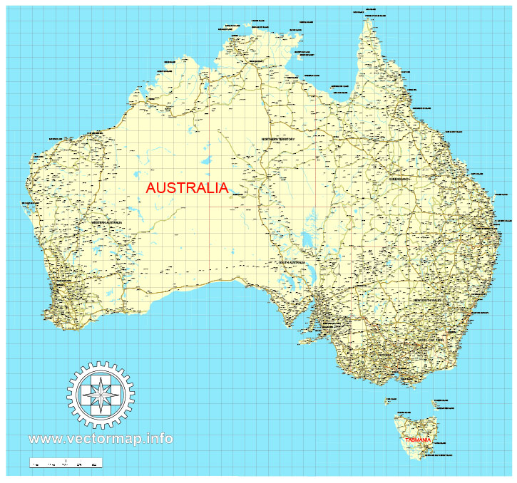
Free download vector map Australia, Adobe Illustrator, download now Free maps vector clipart >>>>>
Map for design, projects, presentation free to use as you like.
Share it!
Small guide: How to work with the vector map?
You can: Mass select objects by type and color – for example, the objects type “building” (they are usually dark gray) – and remove them from the map, if you do not need them in your print or design project. You can also easily change the thickness of lines (streets), just bulk selection the road by the line color.
The streets are separated by type, for example, type “residential road” are usually white with a gray stroke. Highway usually orange with a brown or dark gray stroke.
It is easy to change the font of inscriptions, all or each individually. Also, just can be make and any other manipulation of objects on the vector map in Adobe illustrator format.
Important: All the proportions on the map are true, that is, the relative sizes of the objects are true, because Map is based on an accurate GPS projection, and It transated into the (usual for all) the Mercator projection.
You can easily change the color, stroke and fill of any object on the map, zoom without loss of quality Image Verification.
Select object

Bulk selection the same objects on the vector map

See the bulk selected objects on the vector map

Bulk delete buildungs from the vector map

Select residencial road (small street) on the vector map

Bulk selection the same lines (streets, roads) on the full map

Create fat lines of the streets on the vector maps (bulk action) 1

Create fat lines of the streets on the vector maps (bulk action) 2

Create fat lines of the streets on the vector maps (bulk action) 3

You can easily change the color, stroke and fill of any object on the map, zoom without loss of quality Image Verification.

 Author: Kirill Shrayber, Ph.D. FRGS
, full vector")