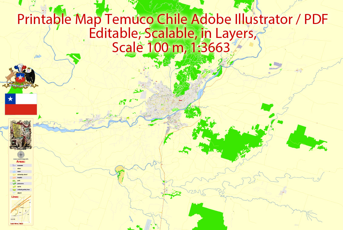
Printable Map Temuco, Chile, exact vector City Plan full editable, Adobe PDF Street Map, Scale 100 m 1:3663, editable text format street names, 19 mb ZIP
All streets named, Main Objects, Principal buildings. Map for design, printing, arts, projects, presentations, for architects, designers and builders, business, logistics.
Layers: color fills, streets_roads, objects, names_objects, names_streets, names_places, grids, legend.
The most exact and detailed map of the city.
DWG, DXF, CDR and other formats – on request, same price, please, contact.
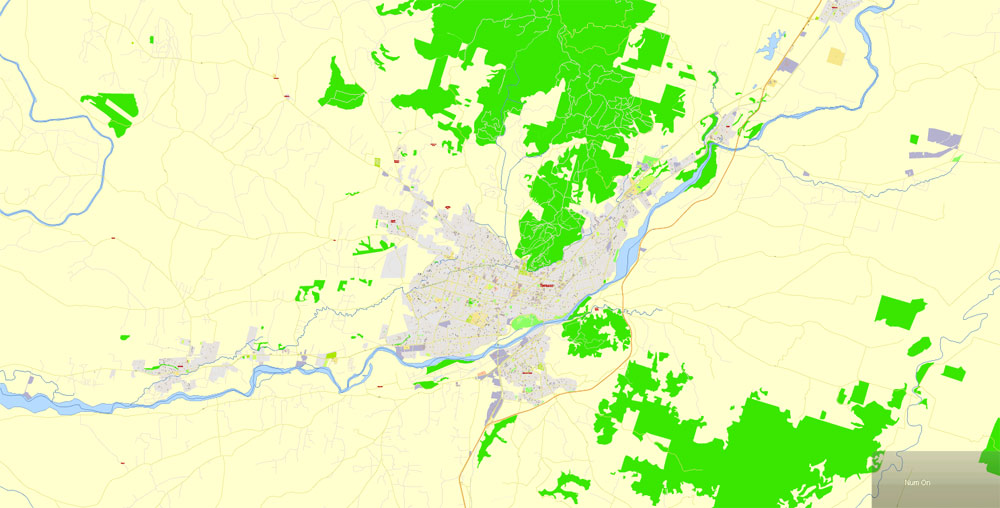
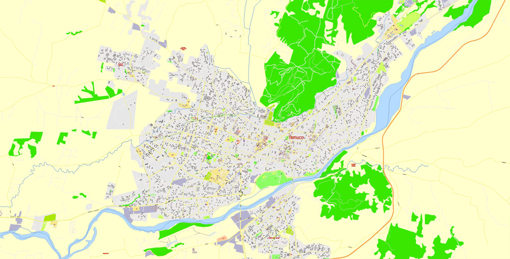
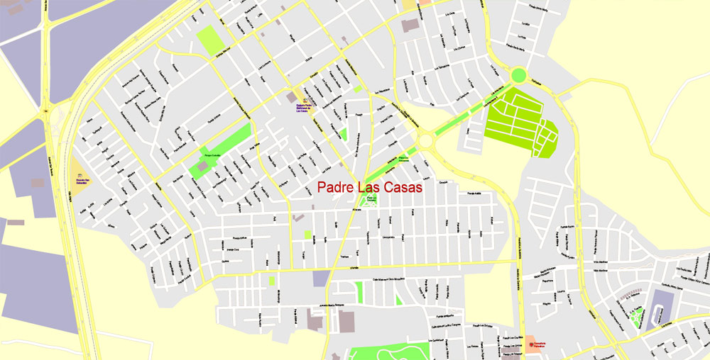
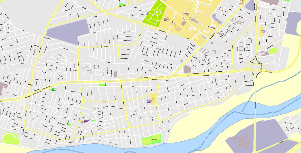
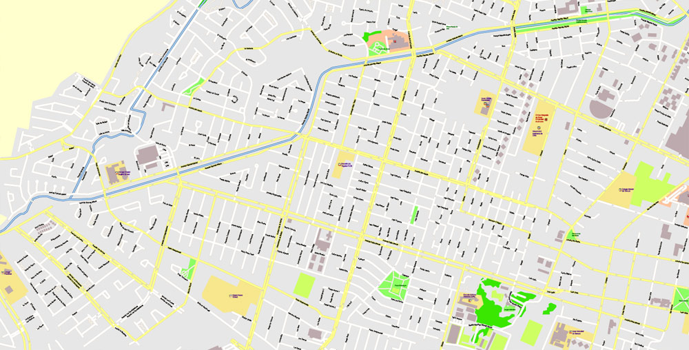
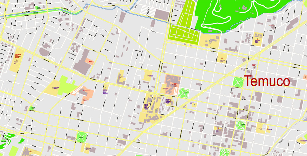
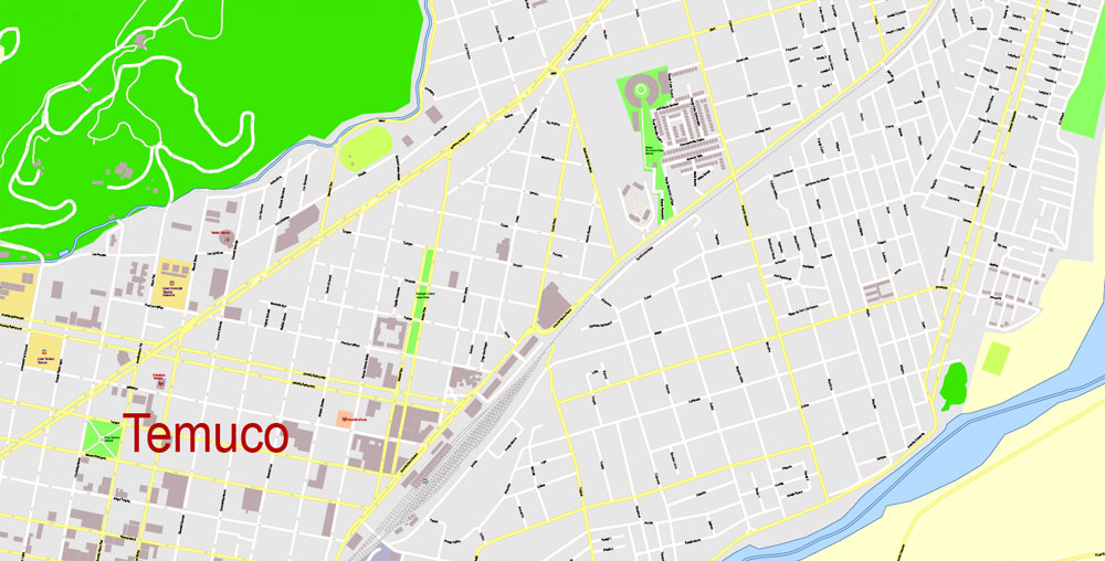
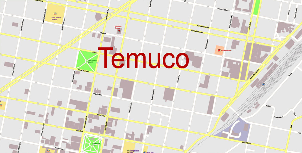
Temuco city, Chile.
This vector map of Temuco city is used as a basis for design, editing, and further printing.
This is the most detailed, exact map of Temuco city for high-quality printing and polygraphy. You can always clarify the map development date by contacting us.
For your convenience, all objects on Temuco vector city map are divided into layers. And the editing is very easy – colors, lines, etc.
You can easily add any objects needed (e.g. shops, salons, sale points, gas station or attraction) on any layer of Temuco vector map.
Temuco is a city and commune, capital of the Cautín Province and of the Araucanía Region in southern Chile. The city is located 670 kilometres (416 miles) south of Santiago at the heart of the modern Araucanía Region and historic Araucanía—the land of the Mapuche who resisted Spanish conquest.
One of the advantages of Temuco city vector maps of our production is the relevance of cartographic data, we constantly update all our products.
This vector map of Temuco city is used by:
designers, layout designers, printers, advertisers and architects. Our product – vector maps – is designed for further editing and printing in large formats – from @Wall format (a few meters) to A-0 and A-1, A-2, A-3.
The Temuco city map in vector format is used for design, urban planning, presentations and media visualizations.
The advertising and presentation map of Temuco city (usually the final designer marks the routes, and puts the client’s objects (shops, saloons, gas stations etc.)
The undoubted advantage is that people will NEVER throw out this advertising product – the map. In fact, as an advertising medium, a city map is the most “long-playing” of the well-known polygraphic advertising media, with the longest lifespan, and the maximum number of interactions with the customer.
Temuco was founded in 1881 during the occupation of Araucanía and grew quickly into one of Chile’s main cities. Temuco’s central place in Araucanía with easy access to the Andean valleys, lakes and coastal areas makes it a hub for tourism, agricultural, livestock and forestry operations as well as a communication and trade centre for the numerous small towns of Araucanía. Temuco has recently been regarded as a university city as it houses two main universities: University of the Frontier and Temuco Catholic University. Nobel laureates Gabriela Mistral and Pablo Neruda both lived in Temuco for some time.
For travelers, maps are sold at the airports and gas stations around the world. Often the source is our vector maps.
Take a look, who purchases our vector maps of Temuco city in “Our Clients and Friends” page – these are large and small companies, from super-brands like Volvo and Starbucks, to small design studios and printing houses.
It’s very easy to work with vector maps of Temuco city, even for a not very experienced designer who can turn on and off the map layers, add new objects, change the colors of fill and lines according to customer requirements.
The undoubted advantage of Temuco city vector maps in printing is an excellent and detailed visualization, when customer can expand a large paper map and instantly define his location, find a landmark, an object or address on map, unlike using the popular electronic formats of Google and Yandex maps for example.
Geography
Temuco is located in a valley in the center-south of Chile, equidistant between the Pacific Ocean to the west and the Andes to the east. Morphologically, the city placement corresponds to Cautín River-originated fluvial land masses that developed in a crushed form between two hills, Ñielol (350m) and Conunhueno (360m).
Printable vector maps of Temuco city are much more convenient and efficient than any electronic maps on your smartphone, because ALL DETAILS are displayed in the entire space of Temuco city map.
Useful tips on working with vector maps of cities and countries in Adobe Illustrator.
«V» – launches the Selection tool (cursor, black arrow), which makes active any vector line.
«А» – launches the Direct Selection tool (white cursor), allows you to select curve elements and drag them to the desired place.
«R» – activates the Rotate tool, which helps you rotating selected objects around the center point by 360 degrees.
«E» – gives you the opportunity to use the Eraser tool and erase unnecessary parts.
«X» – switches between Fill and Stroke in the Tools section. Try to get used to this hot key and
you will quickly understand that you can’t live and work without it.
Guides are not limited to vertical and horizontal in Adobe Illustrator. You can also create a diagonal guide for example. Moreover, you can turn any contours into guides. Select the outline and go to View > Guides > Make Guides (Create Guides), or simply press Cmd/Ctrl + 5. You can also turn the guides back into an editable object. Go to menu, View > Guides > Unlock Guides (Release Guides), select the guide you want to edit and select View > Guides > Release Guides (Reset Guides), or just press Cmd/Ctrl + Option / Alt + 5).
You will probably want to change the color scheme used on our Temuco vector city map.
To quickly and effectively play with colors.
Of course, you can do it manually, all objects in our Temuco city vector map are divided according to types and layers, and you can easily change the color gamma of vector objects in groups and layers.
But there is more effective way of working with the whole VECTOR MAP of Temuco city and all layers:
The overview dialog «Edit colors»/«Repaint Graphic Object» (this dialog box name can change depending on the context):
If you have selected a part or a layer of Temuco city vector map and open the dialog box by clicking the icon in the Control panel, on the Samples palette or the Color Catalog, or if you choose Edit > Edit Colors> Repaint Graphic Object, then the «Repaint Graphic Object» dialog box appears, and you get access to «Assign» and «Edit» tabs.
If a picture or a map fragment is not selected, and you open the dialog box by clicking the icon in the Control panel, on the Samples palette or in the Color Catalog, the «Edit Colors» dialog box appears and you can only access the «Edit» tab.
Regardless of the name at the top of the dialog box, the right-hand side always displays the color group of the current document, as well as two default color groups: Print Color and Grayscale. These color groups can be selected and used any time.
Create and edit color groups of Temuco city vector map, and also assign colors using the «Edit Colors»/ а «Repaint Graphic Object» dialog box.
A. Creating and editing of a color group on the «Edit» tab
B. Assigning colors on the «Assign» tab
C. Select a group of colors from the «Color groups» list
The option «Repaint a graphic object» in the lower part of the dialog box allows you to preview the colors on a selected layer of Vector map, or a group of elements, and specify whether its colors will be redefined when the dialog box is closed.
The main areas of the dialog box are:
«Edit»
The «Edit» tab is designed to create a new or edit the existing color groups.
The harmony rules Menu and the Color Wheel are used to conduct experiments with color harmonies. The color wheel shows how colors are related in color harmony, and the color bars allow you to view and manipulate an individual color values. In addition, you can adjust the brightness, add and remove colors, save color groups and view colors on the selected Vector Map of Temuco city or a separated layers.
«Assign»
The «Assign» tab is used to view and control on how the original colors are replaced with colors from the color group like your corporate colors in the Vector Map of Temuco city.
The assign color ability is provided only if the entire map, layer or fragment is selected in the document. You can specify which of new colors replace the current colors, whether the spot colors should be preserved and how colors are replaced (for example, you can replace colors completely or changing the color tone while maintaining the brightness). The «Assign» tab allows you to redefine colors in the Vector Map of Temuco city, or in separate layers and fragments using the current color group or reducing the number of colors in the current Vector Map.
Any color group can be selected and edited, or used to redefine the colors in the selected vector map of Temuco city, its fragments or elements.
Saving a color group adds this group to the specified list.
Opening the «Edit Colors»/«Repaint Graphic Object» dialog box.
Open the «Edit Colors»/«Repaint Graphic Object» dialog box using one of the following methods:
«Edit»> «Edit Colors»> «Repaint Graphic object» or «Repaint With Style».
Use these commands if you need to edit the colors in the selected vector map of Temuco city.
«Repaint Graphic object» button on the «Control» panel.
Use this button if you need to adjust colors of Temuco city vector map using the а «Repaint graphic object» dialog box.
The specified button is available if the selected vector map or its fragment contains two or more colors.
Note. This color editing method is convenient for global color adjustment in a vector map, if global colors were not used when creating a City Map of Temuco.
The «Edit colors» button or «Edit or apply colors» on the «Color Catalog» palette
Click this button if you need to edit colors on the «Color Catalog» palette or edit and then apply them to the selected Vector Map of Temuco city or its fragment.
The «Edit color group» button or «Edit or apply color group» on the «Samples» palette.
Click this button if you need to edit the colors in the specific color group or edit and apply them to the selected Vector Map of Temuco city or a group of its elements, for example, the whole layer “Streets and lines”. You can also double-click the color group in the Samples panel to open the dialog box.
If the map file is too large and your computer freezes or even can’t open it quickly:
1. Try to reduce the color resolution of the video card (display) to 256 colors while working with a large map.
2. Using Windows Task Manager, select all the application you don’t need, while working with map, just turn them off.
3. Launch Adobe Illustrator. (DO NOT OPEN the vector map file)
4. Start the Windows Task Manager using administrator rights > Find the “Illustrator” process > set the «real time» priority,
5. Open the file. When you see the LEGACY FONT popup window – click “OK” (do not update). You can restore the TEXT later.
6. Can also be useful: When file is opened – Edit > Settings > Basic Settings > disable smoothing. /// It looks scary, but works quickly)))
We recommend saving the file in Adobe Illustrator 10 version. It’s much more stable when working with VERY BIG size files.
Important places
Cerro Ñielol
The Ñielol Hill houses the original temperate forest at this latitude in southern Chile as it was before the Spanish people colonised it. Currently, it has the status of natural monument and as such, it is a protected area. It has also a special meaning for the Mapuche people living in the Region, housing near the top a ceremonial area called La Patagua. We can also find a restaurant at the top of the Hill and a viewpoint of the east side of the city and Padre Las Casas, across the river. It is easily accessed by foot or car. The Southern Andean Volcano Observatory has its office there.
Central market
The central market is one of the best places to get Mapuche crafts. It has a meat market and shops selling woodcrafts, artifacts, wool knits, and similar goods. A fire has recently affected its structure. Reconstruction is planned for 2018, but the original market is currently closed.
Feria Pinto
Edificio Marsano de 1923 – Frente.JPG
Marsano building beside Feria Pinto
One of the most traditional places in the city. Fresh fruits and vegetables are sold here in a daily basis. People from the city and from rural nearby towns come here for trade.
Alemania Avenue
Is the principal artery in Temuco. Here we can find The Araucaria Museum building (19th century Chilean style); the Menchaca Lira Campus of Art Building (a Victorian Style building, recently restored); The English Alley, where we can find the Red Cross Building and not long ago a blue house which was dismantled to be rebuilt elsewhere (as a Heritage recovery project by the school of architecture of a known University of Temuco), both Neoclassical styled. Recently, Alemania Av. has become an important commercial centre. Several restaurants, night clubs, pubs, bistros, pharmacies, boutiques, banks, supermarkets and two shopping malls have been opened there. There is also a Casino and a five stars hotel in the same avenue.
Anibal Pinto Square
The core of Downtown Temuco is the Main Square Anibal Pinto. Temuco’s Main Square is the only one in Chile that was not built with a water fountain in its centre; an art gallery was built in 1981 as part of a total renewal. Compared to other main squares of southern Chile, Temuco’s looks very modern. It was named one of Chile’s most beautiful plazas. It is a tradition, in all creole cities in Chile, that some specific buildings must be in front of the main square; in Temuco, this tradition has been broken. Main Squares are supposed to be surrounded by: a Cathedral (which is in front of Temuco’s main square, as traditionally), the Municipality (which also, is located in front of the square), a Theatre (there used to be a film theatre in front of it), a Fire Station (there is not a fire station in front of the square, as it should), a School (there is no school in front of the main square), and a Bank (there are four banks around the main square).
Temuco
City in Chile
Temuco is a city in central Chile, south of Santiago. Its grand, central square, Plaza Aníbal Pinto, is adorned with imported palm trees. Nearby is the Regional Museum of Araucania, a colonial building housing traditional Mapuche costumes and decorative objects, plus archaeological artifacts like funerary urns. Northeast, the Cerro Ñielol Natural Monument is a hill forested with olive and laurel trees.
Area
• Total 464.0 km2 (179.2 sq mi)
Elevation 360 m (1,180 ft)
Population
• Total 262,530
• Density 570/km2 (1,500/sq mi)
• Urban 232,528
• Rural 12,819
Small guide: How to work with the vector map?
You can: Mass select objects by type and color – for example, the objects type “building” (they are usually dark gray) – and remove them from the map, if you do not need them in your print or design project. You can also easily change the thickness of lines (streets), just bulk selection the road by the line color.
The streets are separated by type, for example, type “residential road” are usually white with a gray stroke. Highway usually orange with a brown or dark gray stroke.
It is easy to change the font of inscriptions, all or each individually. Also, just can be make and any other manipulation of objects on the vector map in Adobe illustrator format.
Important: All the proportions on the map are true, that is, the relative sizes of the objects are true, because Map is based on an accurate GPS projection, and It transated into the (usual for all) the Mercator projection.
You can easily change the color, stroke and fill of any object on the map, zoom without loss of quality Image Verification.
Select object

Bulk selection the same objects on the vector map

See the bulk selected objects on the vector map

Bulk delete buildungs from the vector map

Select residencial road (small street) on the vector map

Bulk selection the same lines (streets, roads) on the full map

Create fat lines of the streets on the vector maps (bulk action) 1

Create fat lines of the streets on the vector maps (bulk action) 2

Create fat lines of the streets on the vector maps (bulk action) 3

You can easily change the color, stroke and fill of any object on the map, zoom without loss of quality Image Verification.
Free vector map World, Adobe Illustrator, download now maps vector clipart
Map for design, projects, presentation free to use as you like.
See also: TERMS & CONDITIONS: SOFTWARE LICENSE AGREEMENT FOR DIGITAL CARTOGRAPHIC DATA.
Need more USA Vector Maps, printable and editable?

 Author: Kirill Shrayber, Ph.D. FRGS