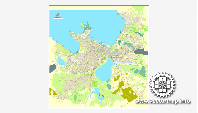
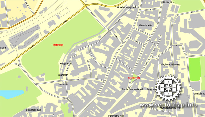
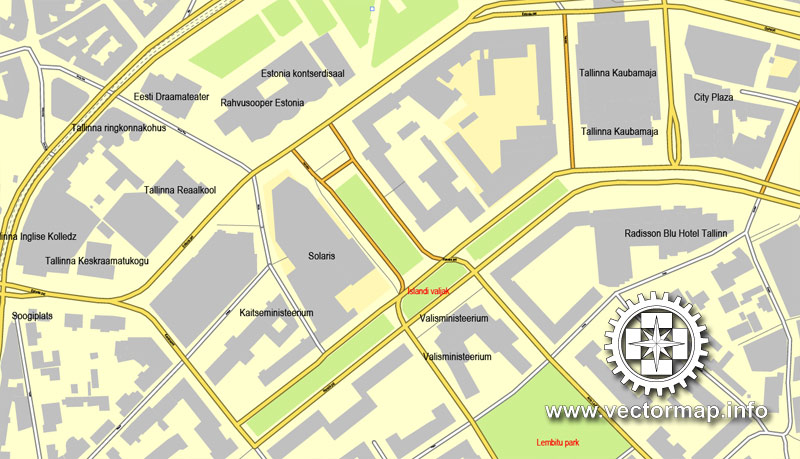
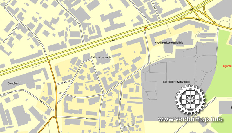
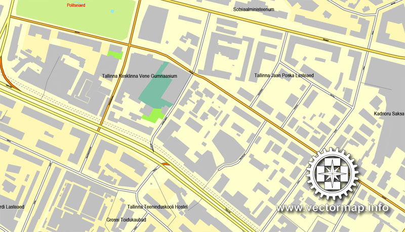
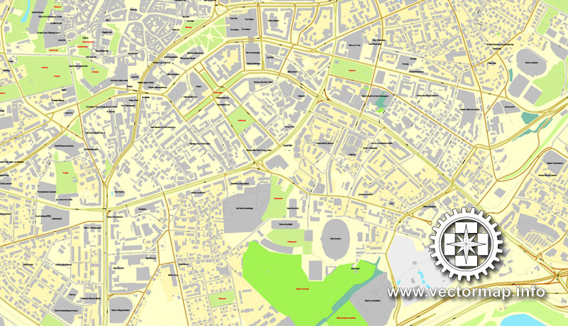
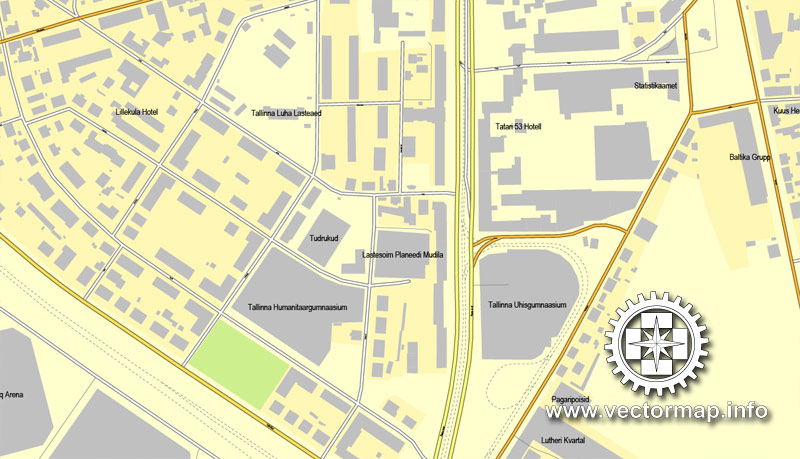
Tallinn, Estonia, printable vector street map, City Plan, full editable, Adobe PDF, Royalty free, full vector, scalable, editable, text format street names, 11 mb ZIP
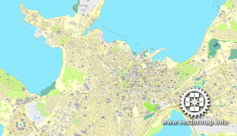
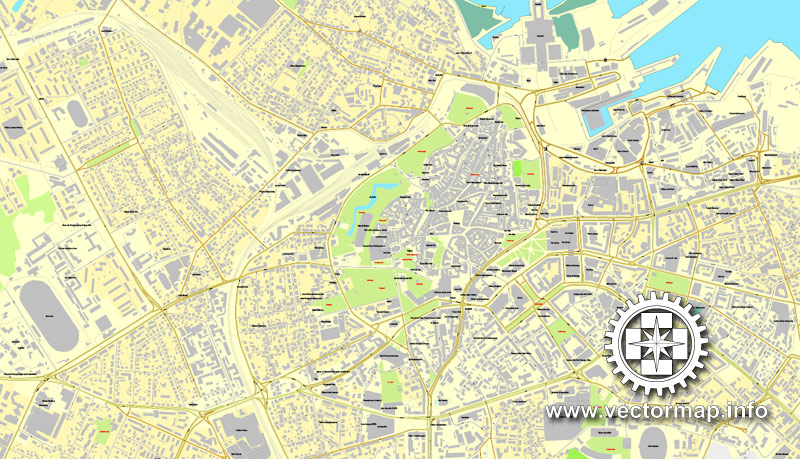
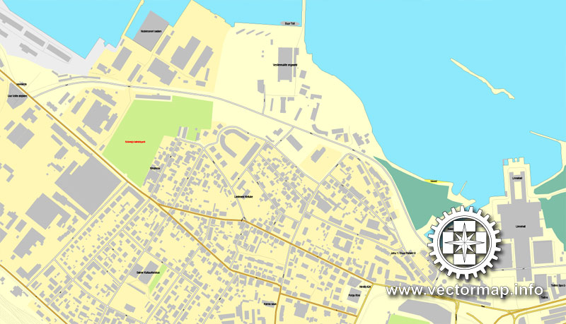
All streets, All buildings.
Map for design, print, arts, projects, presentations, for architects, designers and builders.
You can edit this file by Adobe Illustrator, Adobe Acrobat, Corel Draw.
DXF, DWG, CDR and other formats – on request, same price, please, contact
Tallinn, Estonia.
This vector map of Tallinn city is used as a basis for design, editing, and further printing.
This is the most detailed, exact map of Tallinn city for high-quality printing and polygraphy. You can always clarify the map development date by contacting us.
For your convenience, all objects on Tallinn vector city map are divided into layers. And the editing is very easy – colors, lines, etc.
You can easily add any objects needed (e.g. shops, salons, sale points, gas station or attraction) on any layer of Tallinn vector map.
Tallinn is the capital and largest city of Estonia. It is on the northern coast of the country, on the shore of the Gulf of Finland in Harju County. From the 13th century until 1918 (and briefly during the Nazi occupation of Estonia from 1941 to 1944), the city was known as Reval. Tallinn occupies an area of 159.2 km2 (61.5 sq mi) and has a population of 453,673.
One of the advantages of Tallinn city vector maps of our production is the relevance of cartographic data, we constantly update all our products.
This vector map of Tallinn city is used by:
designers, layout designers, printers, advertisers and architects. Our product – vector maps – is designed for further editing and printing in large formats – from @Wall format (a few meters) to A-0 and A-1, A-2, A-3.
The Tallinn city map in vector format is used for design, urban planning, presentations and media visualizations.
The advertising and presentation map of Tallinn city (usually the final designer marks the routes, and puts the client’s objects (shops, saloons, gas stations etc.)
The undoubted advantage is that people will NEVER throw out this advertising product – the map. In fact, as an advertising medium, a city map is the most “long-playing” of the well-known polygraphic advertising media, with the longest lifespan, and the maximum number of interactions with the customer.
For travelers, maps are sold at the airports and gas stations around the world. Often the source is our vector maps.
Take a look, who purchases our vector maps of Tallinn city in “Our Clients and Friends” page – these are large and small companies, from super-brands like Volvo and Starbucks, to small design studios and printing houses.
It’s very easy to work with vector maps of Tallinn city, even for a not very experienced designer who can turn on and off the map layers, add new objects, change the colors of fill and lines according to customer requirements.
The undoubted advantage of Tallinn city vector maps in printing is an excellent and detailed visualization, when customer can expand a large paper map and instantly define his location, find a landmark, an object or address on map, unlike using the popular electronic formats of Google and Yandex maps for example.
Printable vector maps of Tallinn city are much more convenient and efficient than any electronic maps on your smartphone, because ALL DETAILS are displayed in the entire space of Tallinn city map.
Useful tips on working with vector maps of cities and countries in Adobe Illustrator.
«V» – launches the Selection tool (cursor, black arrow), which makes active any vector line.
«А» – launches the Direct Selection tool (white cursor), allows you to select curve elements and drag them to the desired place.
«R» – activates the Rotate tool, which helps you rotating selected objects around the center point by 360 degrees.
«E» – gives you the opportunity to use the Eraser tool and erase unnecessary parts.
«X» – switches between Fill and Stroke in the Tools section. Try to get used to this hot key and
you will quickly understand that you can’t live and work without it.
Tallinn, first mentioned in 1219, received city rights in 1248, but the earliest human settlements date back 5,000 years. The initial claim over the land was laid by the Danes in 1219, after a successful raid of Lindanise led by Valdemar II of Denmark, followed by a period of alternating Scandinavian and German rule. Due to its strategic location, the city became a major trade hub, especially from the 14th to the 16th century, when it grew in importance as part of the Hanseatic League.
Guides are not limited to vertical and horizontal in Adobe Illustrator. You can also create a diagonal guide for example. Moreover, you can turn any contours into guides. Select the outline and go to View > Guides > Make Guides (Create Guides), or simply press Cmd/Ctrl + 5. You can also turn the guides back into an editable object. Go to menu, View > Guides > Unlock Guides (Release Guides), select the guide you want to edit and select View > Guides > Release Guides (Reset Guides), or just press Cmd/Ctrl + Option / Alt + 5).
You will probably want to change the color scheme used on our Tallinn vector city map.
To quickly and effectively play with colors.
Of course, you can do it manually, all objects in our Tallinn city vector map are divided according to types and layers, and you can easily change the color gamma of vector objects in groups and layers.
Tallinn’s Old Town is one of the best preserved medieval cities in Europe and is listed as a UNESCO World Heritage Site. Tallinn is the major political, financial, cultural and educational center of Estonia. Often dubbed the Silicon Valley of Europe, it has the highest number of startups per person in Europe and is a birthplace of many international companies, including Skype. The city is to house the headquarters of the European Union’s IT agency.
But there is more effective way of working with the whole VECTOR MAP of Tallinn city and all layers:
The overview dialog «Edit colors»/«Repaint Graphic Object» (this dialog box name can change depending on the context):
If you have selected a part or a layer of Tallinn city vector map and open the dialog box by clicking the icon in the Control panel, on the Samples palette or the Color Catalog, or if you choose Edit > Edit Colors> Repaint Graphic Object, then the «Repaint Graphic Object» dialog box appears, and you get access to «Assign» and «Edit» tabs.
If a picture or a map fragment is not selected, and you open the dialog box by clicking the icon in the Control panel, on the Samples palette or in the Color Catalog, the «Edit Colors» dialog box appears and you can only access the «Edit» tab.
Regardless of the name at the top of the dialog box, the right-hand side always displays the color group of the current document, as well as two default color groups: Print Color and Grayscale. These color groups can be selected and used any time.
Create and edit color groups of Tallinn city vector map, and also assign colors using the «Edit Colors»/ а «Repaint Graphic Object» dialog box.
A. Creating and editing of a color group on the «Edit» tab
B. Assigning colors on the «Assign» tab
C. Select a group of colors from the «Color groups» list
The option «Repaint a graphic object» in the lower part of the dialog box allows you to preview the colors on a selected layer of Vector map, or a group of elements, and specify whether its colors will be redefined when the dialog box is closed.
The main areas of the dialog box are:
«Edit»
The «Edit» tab is designed to create a new or edit the existing color groups.
The harmony rules Menu and the Color Wheel are used to conduct experiments with color harmonies. The color wheel shows how colors are related in color harmony, and the color bars allow you to view and manipulate an individual color values. In addition, you can adjust the brightness, add and remove colors, save color groups and view colors on the selected Vector Map of Tallinn city or a separated layers.
Providing to the global cybersecurity it is the home to the NATO Cyber Defence Centre of Excellence. It is ranked as a global city and has been listed among the top 10 digital cities in the world. According to the Global Financial Centres Index Tallinn is the most competitive financial center in Northern Europe and ranks 52nd internationally. The city was a European Capital of Culture for 2011, along with Turku in Finland.
«Assign»
The «Assign» tab is used to view and control on how the original colors are replaced with colors from the color group like your corporate colors in the Vector Map of Tallinn city.
The assign color ability is provided only if the entire map, layer or fragment is selected in the document. You can specify which of new colors replace the current colors, whether the spot colors should be preserved and how colors are replaced (for example, you can replace colors completely or changing the color tone while maintaining the brightness). The «Assign» tab allows you to redefine colors in the Vector Map of Tallinn city, or in separate layers and fragments using the current color group or reducing the number of colors in the current Vector Map.
Color groups
Is a list of all saved color groups for current document (the same groups appear in the «Samples» palette). You can edit and delete the existing color groups, as well as creating a new ones using the list of “Color Groups” in the dialog box. All changes appear in the «Samples» palette.
The highlighted color group shows, which color group is currently edited.
Any color group can be selected and edited, or used to redefine the colors in the selected vector map of Tallinn city, its fragments or elements.
Saving a color group adds this group to the specified list.
Opening the «Edit Colors»/«Repaint Graphic Object» dialog box.
Open the «Edit Colors»/«Repaint Graphic Object» dialog box using one of the following methods:
«Edit»> «Edit Colors»> «Repaint Graphic object» or «Repaint With Style».
Use these commands if you need to edit the colors in the selected vector map of Tallinn city.
«Repaint Graphic object» button on the «Control» panel.
Use this button if you need to adjust colors of Tallinn city vector map using the а «Repaint graphic object» dialog box.
The specified button is available if the selected vector map or its fragment contains two or more colors.
Note. This color editing method is convenient for global color adjustment in a vector map, if global colors were not used when creating a City Map of Tallinn.
The «Edit colors» button or «Edit or apply colors» on the «Color Catalog» palette
Click this button if you need to edit colors on the «Color Catalog» palette or edit and then apply them to the selected Vector Map of Tallinn city or its fragment.
The «Edit color group» button or «Edit or apply color group» on the «Samples» palette.
Click this button if you need to edit the colors in the specific color group or edit and apply them to the selected Vector Map of Tallinn city or a group of its elements, for example, the whole layer “Streets and lines”. You can also double-click the color group in the Samples panel to open the dialog box.
If the map file is too large and your computer freezes or even can’t open it quickly:
1. Try to reduce the color resolution of the video card (display) to 256 colors while working with a large map.
2. Using Windows Task Manager, select all the application you don’t need, while working with map, just turn them off.
3. Launch Adobe Illustrator. (DO NOT OPEN the vector map file)
4. Start the Windows Task Manager using administrator rights > Find the “Illustrator” process > set the «real time» priority,
5. Open the file. When you see the LEGACY FONT popup window – click “OK” (do not update). You can restore the TEXT later.
6. Can also be useful: When file is opened – Edit > Settings > Basic Settings > disable smoothing. /// It looks scary, but works quickly)))
We recommend saving the file in Adobe Illustrator 10 version. It’s much more stable when working with VERY BIG size files.
Geography
Tallinn is situated on the southern coast of the Gulf of Finland, in north-western Estonia.
The largest lake in Tallinn is Lake Ülemiste (9.44 km2 (3.6 sq mi)). It is the main source of the city’s drinking water. Lake Harku is the second largest lake within the borders of Tallinn and its area is 1.6 square kilometres (0.6 sq mi). Tallinn does not lie on a major river. The only significant river in Tallinn is Pirita River in Pirita, a city district counted as a suburb. Historically, the small Härjapea River flowed from Lake Ülemiste through the town into the sea, but the river was diverted for sewage in the 1930s and has since completely disappeared from the cityscape. References to it still remain in the street names Jõe (from Jõgi, river) and Kivisilla (from Kivisild, stone bridge).
A limestone cliff runs through the city. It can be seen at Toompea, Lasnamäe and Astangu. However, Toompea is not a part of the cliff, but a separate hill.
The highest point in Tallinn, at 64 meters above sea level, is situated in Hiiu, Nõmme District, in the south-west of the city.
The length of the coast is 46 kilometres (29 miles). It comprises three bigger peninsulas: Kopli peninsula, Paljassaare peninsula and Kakumäe peninsula. The city has a number of public beaches, including those at Pirita, Stroomi, Kakumäe, Harku and Pikakari.
Tallinn
Capital of Estonia
Tallinn, Estonia’s capital on the Baltic Sea, is the country’s cultural hub. It retains its walled, cobblestoned Old Town, home to cafes and shops, as well as Kiek in de Kök, a 15th-century defensive tower. Its Estonian History Museum is dedicated to the country’s 20th-century history, and its Gothic, towering Town Hall is among the Baltic region’s oldest.
Population: 407,947 (2012) UNdata
Postal code: 15199
Tallinn is the capital and largest city of Estonia. It is situated on the northern coast of the country, on the shore of the Gulf of Finland, 80 km (50 mi) south of Helsinki, east of Stockholm and west of Saint Petersburg. Tallinn occupies an area of 159.2 km2 (61.5 sq mi) and has a population of 440,950. Approximately 32% of Estonia’s total population lives in Tallinn.
Founded in 1248 but the earliest human settlements date back to 3000 years BC, making it one of the oldest capital cities of Northern Europe. Due to its important strategic location the city soon became a major trade hub, especially between the 14th to 16th century when it grew to be a key center of commerce within the Hanseatic League. Tallinn’s Old Town is one of the best preserved and intact medieval cities in Europe and is listed as a UNESCO World Heritage Site. The city was known as Reval from the 13th century until 1918 and again during the Nazi occupation of Estonia from 1941 to 1944.
Tallinn is the major political, financial, cultural and educational center of Estonia. Often dubbed as the Silicon Valley of Europe, it has the highest number of startups per person in Europe and is a birthplace of many international companies including Skype. Providing to the global cybersecurity it is the home to the NATO Cyber Defence Centre of Excellence. It is ranked as a global city and has been listed among the top 10 digital cities in the world. The city was a European Capital of Culture for 2011, along with Turku in Finland.
Tallinn, Eesti, printable vektor linnaplaan, City plaani täis muudetav, Adobe PDF, Tasuta, täis vektor, skaleeritav, muudetav, tekstina tänavanimesid, 11 MB ZIP
Kõik tänavad, kõik hooned.
Kaart disain, print, kunst, projekte, esitlusi, arhitektidele, projekteerijatele ja ehitajatele.
DXF, DWG, CDR ja muudes vormides – soovi korral sama hinnaga, siis kontakt

World map vector, Free vector maps, Vector world map, Vector map, Vector maps, World map, Map of the world, Worldmap, World map vector, World vector map, World relief map, Map of middle east, Map western europe, West europe maps, Map of the world modifiable, High resolution world map, World map illustrator, World map PDF editable, World vector map download,
Free vector map World Planisphere, Adobe Illustrator, download now maps vector clipart
Map for design, projects, presentation free to use as you like.
All Vector World Maps clipart
See also: TERMS & CONDITIONS: SOFTWARE LICENSE AGREEMENT FOR DIGITAL CARTOGRAPHIC DATA
Small guide: How to work with the vector map?
You can: Mass select objects by type and color – for example, the objects type “building” (they are usually dark gray) – and remove them from the map, if you do not need them in your print or design project. You can also easily change the thickness of lines (streets), just bulk selection the road by the line color.
The streets are separated by type, for example, type “residential road” are usually white with a gray stroke. Highway usually orange with a brown or dark gray stroke.
All objects are divided by types: different types of roads and streets, polygons of buildings, landfills, urban areas, parks and more other.
It is easy to change the font of inscriptions, all or each individually. Also, just can be make and any other manipulation of objects on the vector map in Adobe illustrator format.
Important: All the proportions on the map are true, that is, the relative sizes of the objects are true, because Map is based on an accurate GPS projection, and It transated into the (usual for all) the Mercator projection.
You can easily change the color, stroke and fill of any object on the map, zoom without loss of quality Image Verification.
Select object

Bulk selection the same objects on the vector map

See the bulk selected objects on the vector map

Bulk delete buildungs from the vector map

Select residencial road (small street) on the vector map

Bulk selection the same lines (streets, roads) on the full map

Create fat lines of the streets on the vector maps (bulk action) 1

Create fat lines of the streets on the vector maps (bulk action) 2

Create fat lines of the streets on the vector maps (bulk action) 3

You can easily change the color, stroke and fill of any object on the map, zoom without loss of quality Image Verification.

 Author: Kirill Shrayber, Ph.D. FRGS

