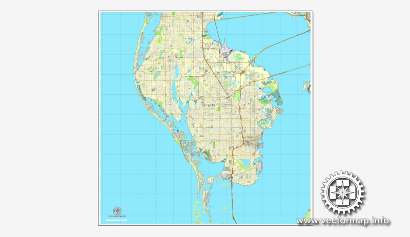
St. Petersburg, Florida, US printable vector street City Plan map V.2, full editable, Adobe PDF, full vector, scalable, editable, text format street names, 17 mb ZIP
All streets, some buildings. Map for design, print, arts, projects, presentations.
You can edit this file by Adobe Illustrator, Adobe Acrobat, Corel Draw.
DWG, DXF, CDR and other formats – on request, same price, please, contact
Saint Petersburg, Florida, USA.
This vector map of Saint Petersburg city is used as a basis for design, editing, and further printing.
This is the most detailed, exact map of Saint Petersburg city for high-quality printing and polygraphy. You can always clarify the map development date by contacting us.
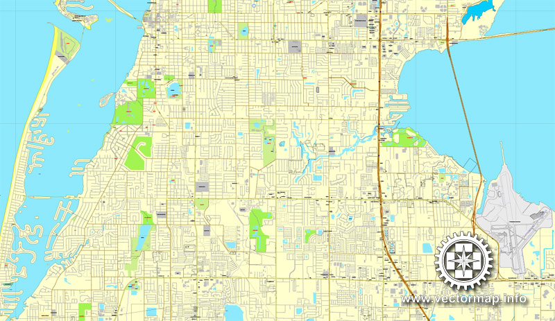
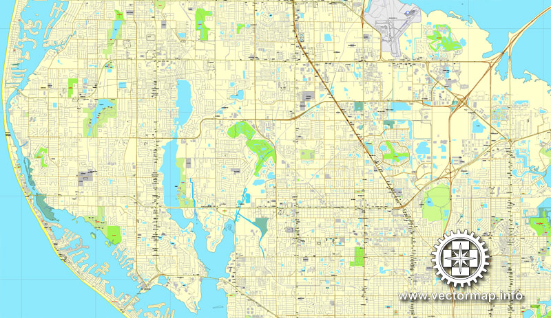
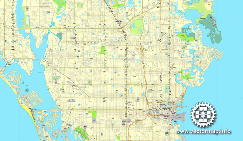
For your convenience, all objects on Saint Petersburg vector city map are divided into layers. And the editing is very easy – colors, lines, etc.
You can easily add any objects needed (e.g. shops, salons, sale points, gas station or attraction) on any layer of Saint Petersburg vector map.
St. Petersburg is a city in Pinellas County, Florida, United States. As of the 2015 census estimate, the population was 257,083, making it the fifth-most populous city in Florida and the largest in the state that is not a county seat (the city of Clearwater is the seat of Pinellas County).
One of the advantages of Saint Petersburg city vector maps of our production is the relevance of cartographic data, we constantly update all our products.
This vector map of Saint Petersburg city is used by:
designers, layout designers, printers, advertisers and architects. Our product – vector maps – is designed for further editing and printing in large formats – from @Wall format (a few meters) to A-0 and A-1, A-2, A-3.
The Saint Petersburg city map in vector format is used for design, urban planning, presentations and media visualizations.
The advertising and presentation map of Saint Petersburg city (usually the final designer marks the routes, and puts the client’s objects (shops, saloons, gas stations etc.)
The undoubted advantage is that people will NEVER throw out this advertising product – the map. In fact, as an advertising medium, a city map is the most “long-playing” of the well-known polygraphic advertising media, with the longest lifespan, and the maximum number of interactions with the customer.
St. Petersburg is the second-largest city in the Tampa Bay Area, after Tampa. Together with Clearwater, these cities comprise the Tampa–St. Petersburg–Clearwater Metropolitan Statistical Area, the second-largest in Florida with a population of around 2.8 million. St. Petersburg is located on the Pinellas peninsula between Tampa Bay and the Gulf of Mexico, and is connected to mainland Florida to the north.
For travelers, maps are sold at the airports and gas stations around the world. Often the source is our vector maps.
Take a look, who purchases our vector maps of Saint Petersburg city in “Our Clients and Friends” page – these are large and small companies, from super-brands like Volvo and Starbucks, to small design studios and printing houses.
It’s very easy to work with vector maps of Saint Petersburg city, even for a not very experienced designer who can turn on and off the map layers, add new objects, change the colors of fill and lines according to customer requirements.
The undoubted advantage of Saint Petersburg city vector maps in printing is an excellent and detailed visualization, when customer can expand a large paper map and instantly define his location, find a landmark, an object or address on map, unlike using the popular electronic formats of Google and Yandex maps for example.
Printable vector maps of Saint Petersburg city are much more convenient and efficient than any electronic maps on your smartphone, because ALL DETAILS are displayed in the entire space of Saint Petersburg city map.
St. Petersburg was founded in 1888 by John C. Williams, who purchased the land, and by Peter Demens, who brought the railroad industry into the area. As a part of a coin toss bet, the winner, Peter Demens, named the land after Saint Petersburg, Russia, while Williams opted to name the first hotel built which was named the Detroit Hotel, both named after their home towns respectively. St. Petersburg was incorporated as a town on February 29, 1892 and re-incorporated as a city on June 6, 1903.
Useful tips on working with vector maps of cities and countries in Adobe Illustrator.
«V» – launches the Selection tool (cursor, black arrow), which makes active any vector line.
«А» – launches the Direct Selection tool (white cursor), allows you to select curve elements and drag them to the desired place.
«R» – activates the Rotate tool, which helps you rotating selected objects around the center point by 360 degrees.
«E» – gives you the opportunity to use the Eraser tool and erase unnecessary parts.
«X» – switches between Fill and Stroke in the Tools section. Try to get used to this hot key and
you will quickly understand that you can’t live and work without it.
Guides are not limited to vertical and horizontal in Adobe Illustrator. You can also create a diagonal guide for example. Moreover, you can turn any contours into guides. Select the outline and go to View > Guides > Make Guides (Create Guides), or simply press Cmd/Ctrl + 5. You can also turn the guides back into an editable object. Go to menu, View > Guides > Unlock Guides (Release Guides), select the guide you want to edit and select View > Guides > Release Guides (Reset Guides), or just press Cmd/Ctrl + Option / Alt + 5).
The city is often referred to by locals as St. Pete. Neighboring St. Pete Beach formally shortened its name in 1994 after a vote by its residents. St. Petersburg is governed by a mayor and city council.
With an average of some 361 days of sunshine each year, and a Guinness World Record for logging the most consecutive days of sunshine (768 days), it is nicknamed “The Sunshine City”. Due to its good weather and low cost of living, the city has long been a popular retirement destination, although in recent years the population has moved in a much more youthful direction. American Style magazine ranked St. Petersburg its top mid-size city in 2011, citing its “vibrant” arts scene.
You will probably want to change the color scheme used on our Saint Petersburg vector city map.
To quickly and effectively play with colors.
Of course, you can do it manually, all objects in our Saint Petersburg city vector map are divided according to types and layers, and you can easily change the color gamma of vector objects in groups and layers.
But there is more effective way of working with the whole VECTOR MAP of Saint Petersburg city and all layers:
The overview dialog «Edit colors»/«Repaint Graphic Object» (this dialog box name can change depending on the context):
If you have selected a part or a layer of Saint Petersburg city vector map and open the dialog box by clicking the icon in the Control panel, on the Samples palette or the Color Catalog, or if you choose Edit > Edit Colors> Repaint Graphic Object, then the «Repaint Graphic Object» dialog box appears, and you get access to «Assign» and «Edit» tabs.
Geography
Topography
According to the United States Census Bureau, the city has a total area of 137.6 square miles (356.4 km2). 61.7 square miles (159.9 km2) of it is land, and 75.9 square miles (196.5 km2) of it (55.13%) is water. St. Petersburg is bordered by three bodies of water, the Old Tampa Bay, Middle Tampa Bay, and Lower Tampa Bay, all of which form the Tampa Bay.
If a picture or a map fragment is not selected, and you open the dialog box by clicking the icon in the Control panel, on the Samples palette or in the Color Catalog, the «Edit Colors» dialog box appears and you can only access the «Edit» tab.
Regardless of the name at the top of the dialog box, the right-hand side always displays the color group of the current document, as well as two default color groups: Print Color and Grayscale. These color groups can be selected and used any time.
Create and edit color groups of Saint Petersburg city vector map, and also assign colors using the «Edit Colors»/ а «Repaint Graphic Object» dialog box.
A. Creating and editing of a color group on the «Edit» tab
B. Assigning colors on the «Assign» tab
C. Select a group of colors from the «Color groups» list
The option «Repaint a graphic object» in the lower part of the dialog box allows you to preview the colors on a selected layer of Vector map, or a group of elements, and specify whether its colors will be redefined when the dialog box is closed.
The main areas of the dialog box are:
«Edit»
The «Edit» tab is designed to create a new or edit the existing color groups.
The harmony rules Menu and the Color Wheel are used to conduct experiments with color harmonies. The color wheel shows how colors are related in color harmony, and the color bars allow you to view and manipulate an individual color values. In addition, you can adjust the brightness, add and remove colors, save color groups and view colors on the selected Vector Map of Saint Petersburg city or a separated layers.
«Assign»
The «Assign» tab is used to view and control on how the original colors are replaced with colors from the color group like your corporate colors in the Vector Map of Saint Petersburg city.
The assign color ability is provided only if the entire map, layer or fragment is selected in the document. You can specify which of new colors replace the current colors, whether the spot colors should be preserved and how colors are replaced (for example, you can replace colors completely or changing the color tone while maintaining the brightness). The «Assign» tab allows you to redefine colors in the Vector Map of Saint Petersburg city, or in separate layers and fragments using the current color group or reducing the number of colors in the current Vector Map.
Color groups
Is a list of all saved color groups for current document (the same groups appear in the «Samples» palette). You can edit and delete the existing color groups, as well as creating a new ones using the list of “Color Groups” in the dialog box. All changes appear in the «Samples» palette.
The highlighted color group shows, which color group is currently edited.
Any color group can be selected and edited, or used to redefine the colors in the selected vector map of Saint Petersburg city, its fragments or elements.
Downtown
Downtown St. Petersburg is the Central Business District, containing high rises for office use, most notably the tallest building in the city, One Progress Plaza. The Tampa Bay Times newspaper is headquartered in the downtown area. The Poynter Institute, which owns the paper, is located on 3rd Street South.
The Mahaffey Theater complex, the Morean Arts Center, dozens of other art galleries, Haslam’s Bookstore, The Coliseum, Palladium Theatre, and Jannus Live are among the galleries and cultural venues featured downtown. Several prominent museums are located in the perimeter. Many of them have received notable accolades, including the Chihuly Collection presented by the Morean Arts Center, the Museum of Fine Arts, the Salvador Dalí Museum, the now-closed Florida International Museum, the St. Petersburg Museum of History, and the Florida Holocaust Museum. The city hosts many outdoor festivals throughout the year.
Saving a color group adds this group to the specified list.
Opening the «Edit Colors»/«Repaint Graphic Object» dialog box.
Open the «Edit Colors»/«Repaint Graphic Object» dialog box using one of the following methods:
«Edit»> «Edit Colors»> «Repaint Graphic object» or «Repaint With Style».
Use these commands if you need to edit the colors in the selected vector map of Saint Petersburg city.
«Repaint Graphic object» button on the «Control» panel.
Use this button if you need to adjust colors of Saint Petersburg city vector map using the а «Repaint graphic object» dialog box.
The specified button is available if the selected vector map or its fragment contains two or more colors.
Note. This color editing method is convenient for global color adjustment in a vector map, if global colors were not used when creating a City Map of Saint Petersburg.
The «Edit colors» button or «Edit or apply colors» on the «Color Catalog» palette
Click this button if you need to edit colors on the «Color Catalog» palette or edit and then apply them to the selected Vector Map of Saint Petersburg city or its fragment.
The «Edit color group» button or «Edit or apply color group» on the «Samples» palette.
Click this button if you need to edit the colors in the specific color group or edit and apply them to the selected Vector Map of Saint Petersburg city or a group of its elements, for example, the whole layer “Streets and lines”. You can also double-click the color group in the Samples panel to open the dialog box.
If the map file is too large and your computer freezes or even can’t open it quickly:
1. Try to reduce the color resolution of the video card (display) to 256 colors while working with a large map.
2. Using Windows Task Manager, select all the application you don’t need, while working with map, just turn them off.
3. Launch Adobe Illustrator. (DO NOT OPEN the vector map file)
4. Start the Windows Task Manager using administrator rights > Find the “Illustrator” process > set the «real time» priority,
5. Open the file. When you see the LEGACY FONT popup window – click “OK” (do not update). You can restore the TEXT later.
6. Can also be useful: When file is opened – Edit > Settings > Basic Settings > disable smoothing. /// It looks scary, but works quickly)))
We recommend saving the file in Adobe Illustrator 10 version. It’s much more stable when working with VERY BIG size files.
St. Petersburg’s downtown has been rated among the best in the South. The area’s beaches are a 10-mile (16 km) drive from downtown. Jutting a half mile into the bay was the St. Petersburg Pier, a major tourist attraction that offered various activities. “The Lens” design which was chosen by the International Design Competition Jury and accepted by City Council later had its contract terminated by a citywide election during the summer of 2013. Following this, the “Pier Park” was chosen out of the 16 new design teams that submitted work in late 2014 and in 2015 the Pier Park was set for construction in early 2017.
Downtown also contains the University of South Florida St. Petersburg and a downtown branch of St. Petersburg College. The downtown perimeter includes several parks, most of which are waterfront or lakefront. Straub Park is nearly a half mile long, boasts a waterfront location, and is home of the St. Petersburg Museum of Fine Arts. Because of the amount parks downtown has to offer, The Trust for Public Land ranks St. Petersburg 1st in Florida and 15th out of 100 of the largest cities in the U.S. based off how well cities are meeting their needs for parks. The Vinoy Park Hotel has a bayfront location, a spot on the National Register of Historic Places, and an AAA Four-Diamond rating. It fronts Vinoy Park, which holds music festivals, including the Warped Tour. Nearby is the historic Tramor Cafeteria building, now part of the Tampa Bay Times. The city is connected via the Looper Trolley.
Most of the dining and nightlife can be found downtown on or near Central Avenue or Beach Drive along the waterfront. Venues include Jannus Live and the State Theatre. The active nightlife scene is credited to recent demographic and regulatory changes. In 2010, the city council voted to extend bar hours until 3 A.M., identical to cross-bay “rival” Tampa.
Tropicana Field, home of Major League Baseball’s Tampa Bay Rays, is located in the western part of downtown. Until 2008, the team played its spring training games at nearby Progress Energy Park. This setup was unique, making St. Petersburg the first city that played host to its baseball team during spring training as well as the regular season since the 1919 Philadelphia Athletics. At the end of 2007, there was a debate over a new stadium to be built on the downtown waterfront at the current Progress Energy Park site. Tropicana Field would be demolished and replaced with prime residential and retail space. Completion of the stadium was planned for 2012; however, the proposal has been tabled indefinitely while a community-based organization investigates all alternatives for new stadium construction.
When the Wikimedia Foundation was founded by Jimmy Wales in 2003 it was originally located in downtown St. Petersburg. The foundation adopted its articles of incorporation in the city in 2005. On September 25, 2007, the Foundation announced its move in late 2007 from St. Petersburg to the San Francisco Bay Area.
St. Petersburg has the third-largest dedicated public waterfront park system in North America, with a waterfront park system that stretches 7 miles (11 km) and is used year-round for public events, festivals and other activities. In the early 20th century, citizens and city leaders engaged in a long and boisterous debate over the future of the young city’s waterfront space, with one side advocating for commercial, port and industrial development and the other side advocating for a long-term commitment to parks and public access to the waterfront. The public access and park contingent won the debate when, on Christmas Eve 1909, the city announced the acquisition of the waterfront land that is encompassed by the waterfront park system.
The city is also becoming one of the largest destinations in Florida for kiteboarding with locations such as Fort De Soto Park, Pass-a-Grille, and Ten-Cent.
The St. Petersburg Shuffleboard Club was established in 1924 and gained attention as the “World’s Largest Shuffleboard Club” with 110 courts and over 5,000 members in the 1950s and 1960s.
Neighborhoods
St. Petersburg is home to more than 100 neighborhoods, with most of the historic districts located near the bay. In the eastern center of the city is Downtown St. Petersburg, which includes the city’s residential and commercial skyscrapers, art galleries, museums, and parks. The downtown area is home to the central business district and to many start-up companies, corporation branches, banks, law firms, and restaurants. Apart from downtown’s business and cultural aesthetics, the area also includes a branch of St. Petersburg College and the University of South Florida St. Petersburg. The downtown district is home to two professional sports teams, the Tampa Bay Rays, which resides west of downtown at Tropicana Field, and the Tampa Bay Rowdies, which is located downtown at Al Lang Stadium.
North of Downtown St. Petersburg lie Historic Old Northeast and Snell Isle, which both have Mediterranean style historic and waterfront homes, parks, and recreational areas. Old Northeast is also home to a shopping district, city landmarks, beaches, and small shops as well as small residential high rises. Snell Isle was founded by C. Perry Snell who bought up the land to develop upscale properties in the 1900s, and helped create some of St. Petersburg’s resorts such as the Vinoy Park Hotel and the St. Petersburg Woman’s Club, both of which are listed on the U.S. National Register of Historic Places.
The western side of St. Petersburg includes the Grand Central District and Historic Kenwood. The Grand Central District houses the cities cafes, art galleries, restaurants, and bars all owing to the Renaissance style architecture. Historic Kenwood is filled with art studios and galleries similarly to the Grand Central District.
Small guide: How to work with the vector map?
You can: Mass select objects by type and color – for example, the objects type “building” (they are usually dark gray) – and remove them from the map, if you do not need them in your print or design project. You can also easily change the thickness of lines (streets), just bulk selection the road by the line color.
The streets are separated by type, for example, type “residential road” are usually white with a gray stroke. Highway usually orange with a brown or dark gray stroke.
It is easy to change the font of inscriptions, all or each individually. Also, just can be make and any other manipulation of objects on the vector map in Adobe illustrator format.
Important: All the proportions on the map are true, that is, the relative sizes of the objects are true, because Map is based on an accurate GPS projection, and It transated into the (usual for all) the Mercator projection.
You can easily change the color, stroke and fill of any object on the map, zoom without loss of quality Image Verification.
Select object

Bulk selection the same objects on the vector map

See the bulk selected objects on the vector map

Bulk delete buildungs from the vector map

Select residencial road (small street) on the vector map

Bulk selection the same lines (streets, roads) on the full map

Create fat lines of the streets on the vector maps (bulk action) 1

Create fat lines of the streets on the vector maps (bulk action) 2

Create fat lines of the streets on the vector maps (bulk action) 3

You can easily change the color, stroke and fill of any object on the map, zoom without loss of quality Image Verification.

 Author: Kirill Shrayber, Ph.D. FRGS


