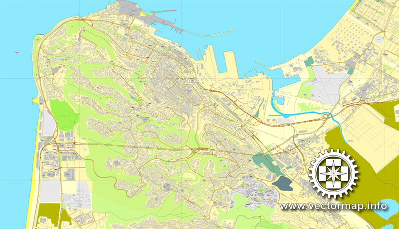
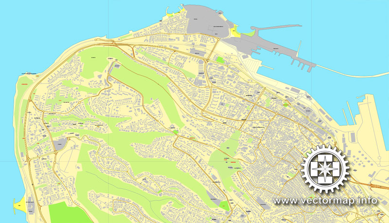
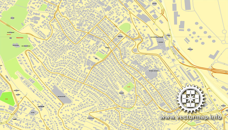
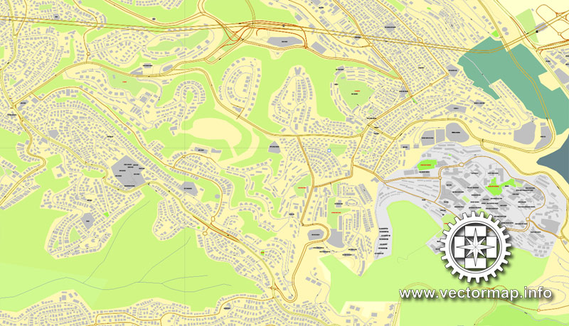
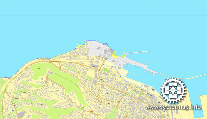
Haifa, Israel, printable vector street map, City Plan, fully editable, Adobe PDF, Royalty free, full vector, scalable, editable, 6 Mb ZIP
All streets, All buildings.
NO CORRECT NAMES STREET!
Map for design, print, arts, projects, presentations, for architects, designers and builders.
You can edit this file by Adobe Illustrator, Adobe Acrobat, Corel Draw.
DXF, DWG, CDR and other formats – on request, same price, please, contact.
Haifa, Israel.
This vector map of Haifa is used as a basis for design, editing, and further printing.
This is the most detailed, exact map of Haifa for high-quality printing and polygraphy. You can always clarify the map development date by contacting us.
For your convenience, all objects on Haifa vector map are divided into layers. And the editing is very easy – colors, lines, etc.
You can easily add any objects needed (e.g. shops, salons, sale points, gas station or attraction) on any layer of Haifa vector map.
Haifa is the third-largest city in Israel – after Jerusalem and Tel Aviv– with a population of 281,087 in 2017. The city of Haifa forms part of the Haifa metropolitan area, the second- or third-most populous metropolitan area in Israel. It is home to the Bahá’í World Centre, a UNESCO World Heritage Site and a destination for Bahá’í pilgrims.

One of the advantages of Haifa vector maps of our production is the relevance of cartographic data, we constantly update all our products.
This vector map of Haifa is used by:
designers, layout designers, printers, advertisers and architects. Our product – vector maps – is designed for further editing and printing in large formats – from @Wall format (a few meters) to A-0 and A-1, A-2, A-3.
Haifa map in vector format is used for design, urban planning, presentations and media visualizations.
Advertising and presentation map of Haifa (usually the final designer marks the routes, and puts the client’s objects (shops, saloons, gas stations etc.)
The undoubted advantage is that people will NEVER throw out this advertising product – the map. In fact, as an advertising medium, a map is the most “long-playing” of the well-known polygraphic advertising media, with the longest lifespan, and the maximum number of interactions with the customer.
For travelers, maps are sold at the airports and gas stations around the world. Often the source is our vector maps.
Take a look, who purchases our vector maps of Haifa in “Our Clients and Friends” page – these are large and small companies, from super-brands like Volvo and Starbucks, to small design studios and printing houses.
It’s very easy to work with vector maps of Haifa, even for a not very experienced designer who can turn on and off the map layers, add new objects, change the colors of fill and lines according to customer requirements.
The undoubted advantage of Haifa vector maps in printing is an excellent and detailed visualization, when customer can expand a large paper map and instantly define his location, find a landmark, an object or address on map, unlike using the popular electronic formats of Google and Yandex maps for example.
Printable vector maps of Haifa are much more convenient and efficient than any electronic maps on your smartphone, because ALL DETAILS are displayed in the entire space of Haifa map.
Useful tips on working with vector maps of cities and countries in Adobe Illustrator.
«V» – launches the Selection tool (cursor, black arrow), which makes active any vector line.
«А» – launches the Direct Selection tool (white cursor), allows you to select curve elements and drag them to the desired place.
«R» – activates the Rotate tool, which helps you rotating selected objects around the center point by 360 degrees.
«E» – gives you the opportunity to use the Eraser tool and erase unnecessary parts.
«X» – switches between Fill and Stroke in the Tools section. Try to get used to this hot key and
you will quickly understand that you can’t live and work without it.
Guides are not limited to vertical and horizontal in Adobe Illustrator. You can also create a diagonal guide for example. Moreover, you can turn any contours into guides. Select the outline and go to View > Guides > Make Guides (Create Guides), or simply press Cmd/Ctrl + 5. You can also turn the guides back into an editable object. Go to menu, View > Guides > Unlock Guides (Release Guides), select the guide you want to edit and select View > Guides > Release Guides (Reset Guides), or just press Cmd/Ctrl + Option / Alt + 5).
You will probably want to change the color scheme used on our Haifa vector map.
To quickly and effectively play with colors.
Of course, you can do it manually, all objects in our Haifa vector map are divided according to types and layers, and you can easily change the color gamma of vector objects in groups and layers.
But there is more effective way of working with the whole VECTOR MAP of Haifa and all layers:
The overview dialog «Edit colors»/«Repaint Graphic Object» (this dialog box name can change depending on the context):
If you have selected a part or a layer of Haifa vector map and open the dialog box by clicking the icon in the Control panel, on the Samples palette or the Color Catalog, or if you choose Edit > Edit Colors> Repaint Graphic Object, then the «Repaint Graphic Object» dialog box appears, and you get access to «Assign» and «Edit» tabs.
If a picture or a map fragment is not selected, and you open the dialog box by clicking the icon in the Control panel, on the Samples palette or in the Color Catalog, the «Edit Colors» dialog box appears and you can only access the «Edit» tab.
Regardless of the name at the top of the dialog box, the right-hand side always displays the color group of the current document, as well as two default color groups: Print Color and Grayscale. These color groups can be selected and used any time.
Create and edit color groups of Haifa vector map, and also assign colors using the «Edit Colors»/ а «Repaint Graphic Object» dialog box.
A. Creating and editing of a color group on the «Edit» tab
B. Assigning colors on the «Assign» tab
C. Select a group of colors from the «Color groups» list
The option «Repaint a graphic object» in the lower part of the dialog box allows you to preview the colors on a selected layer of Vector map, or a group of elements, and specify whether its colors will be redefined when the dialog box is closed.
Built on the slopes of Mount Carmel, the settlement has a history spanning more than 3,000 years. The earliest known settlement in the vicinity was Tell Abu Hawam, a small port city established in the Late Bronze Age (14th century BCE). In the 3rd century CE, Haifa was known as a dye-making center. Over the millennia, the city has changed hands: being conquered and ruled by the Canaanites, Israelites, Phoenicians, Persians, Hasmoneans, Romans, Byzantines, Arabs, Crusaders, Ottomans, and the British. Since the establishment of the State of Israel in 1948, the Haifa Municipality has governed the city.
The main areas of the dialog box are:
«Edit»
The «Edit» tab is designed to create a new or edit the existing color groups.
The harmony rules Menu and the Color Wheel are used to conduct experiments with color harmonies. The color wheel shows how colors are related in color harmony, and the color bars allow you to view and manipulate an individual color values. In addition, you can adjust the brightness, add and remove colors, save color groups and view colors on the selected Vector Map of Haifa or a separated layers.
«Assign»
The «Assign» tab is used to view and control on how the original colors are replaced with colors from the color group like your corporate colors in the Vector Map of Haifa.
The assign color ability is provided only if the entire map, layer or fragment is selected in the document. You can specify which of new colors replace the current colors, whether the spot colors should be preserved and how colors are replaced (for example, you can replace colors completely or changing the color tone while maintaining the brightness). The «Assign» tab allows you to redefine colors in the Vector Map of Haifa, or in separate layers and fragments using the current color group or reducing the number of colors in the current Vector Map.
Color groups
Is a list of all saved color groups for current document (the same groups appear in the «Samples» palette). You can edit and delete the existing color groups, as well as creating a new ones using the list of “Color Groups” in the dialog box. All changes appear in the «Samples» palette.
The highlighted color group shows, which color group is currently edited.
Any color group can be selected and edited, or used to redefine the colors in the selected vector map of Haifa, its fragments or elements.
Saving a color group adds this group to the specified list.
Opening the «Edit Colors»/«Repaint Graphic Object» dialog box.
Open the «Edit Colors»/«Repaint Graphic Object» dialog box using one of the following methods:
«Edit»> «Edit Colors»> «Repaint Graphic object» or «Repaint With Style».
Use these commands if you need to edit the colors in the selected vector map of Haifa.
«Repaint Graphic object» button on the «Control» panel.
Use this button if you need to adjust colors of Haifa vector map using the а «Repaint graphic object» dialog box.
The specified button is available if the selected vector map or its fragment contains two or more colors.
Note. This color editing method is convenient for global color adjustment in a vector map, if global colors were not used when creating a Map of Haifa.
The «Edit colors» button or «Edit or apply colors» on the «Color Catalog» palette
Click this button if you need to edit colors on the «Color Catalog» palette or edit and then apply them to the selected Vector Map of Haifa or its fragment.
The «Edit color group» button or «Edit or apply color group» on the «Samples» palette.
Click this button if you need to edit the colors in the specific color group or edit and apply them to the selected Vector Map of Haifa or a group of its elements, for example, the whole layer “Streets and lines”. You can also double-click the color group in the Samples panel to open the dialog box.
If the map file is too large and your computer freezes or even can’t open it quickly:
1. Try to reduce the color resolution of the video card (display) to 256 colors while working with a large map.
2. Using Windows Task Manager, select all the application you don’t need, while working with map, just turn them off.
3. Launch Adobe Illustrator. (DO NOT OPEN the vector map file)
4. Start the Windows Task Manager using administrator rights > Find the “Illustrator” process > set the «real time» priority,
5. Open the file. When you see the LEGACY FONT popup window – click “OK” (do not update). You can restore the TEXT later.
6. Can also be useful: When file is opened – Edit > Settings > Basic Settings > disable smoothing. /// It looks scary, but works quickly)))
We recommend saving the file in Adobe Illustrator 10 version. It’s much more stable when working with VERY BIG size files.
As of 2016, the city is a major seaport located on Israel’s Mediterranean coastline in the Bay of Haifa covering 63.7 square kilometres (24.6 sq mi). It lies about 90 kilometres (56 mi) north of Tel Aviv and is the major regional center of northern Israel. According to researcher Jonathan Kis-Lev, Haifa is considered a relative haven for coexistence between Jews and Arabs. Two respected academic institutions, the University of Haifa and the Technion, are located in Haifa, in addition to the largest k-12 school in Israel, the Hebrew Reali School. The city plays an important role in Israel’s economy. It is home to Matam, one of the oldest and largest high-tech parks in the country; Haifa also owns the only underground rapid transit system located in Israel, known as the Carmelit. Haifa Bay is a center of heavy industry, petroleum refining and chemical processing. Haifa formerly functioned as the western terminus of an oil pipeline from Iraq via Jordan.
Geography
Haifa is situated on the Israeli Mediterranean Coastal Plain, the historic land bridge between Europe, Africa, and Asia, and the mouth of the Kishon River. Located on the northern slopes of Mount Carmel and around Haifa Bay, the city is split over three tiers. The lowest is the center of commerce and industry including the Port of Haifa. The middle level is on the slopes of Mount Carmel and consists of older residential neighborhoods, while the upper level consists of modern neighborhoods looking over the lower tiers. From here views can be had across the Western Galilee region of Israel towards Rosh HaNikra and the Lebanese border. Haifa is about 90 kilometers (55.9 mi) north of the city of Tel Aviv, and has a large number of beaches on the Mediterranean.
Haifa
City in Israel
Haifa is a northern Israeli port city built in tiers extending from the Mediterranean up the north slope of Mount Carmel. The city’s most iconic sites are the immaculately landscaped terraces of the Bahá’í Gardens and, at their heart, the gold-domed Shrine of the Báb. At the foot of the gardens lies the German Colony, with shops, galleries and restaurants in 19th-century buildings.
Area: 63.67 km²
Population: 270,814 (2012) UNdata
Area code: 4
Number of airports: 1
Haifa, the third-largest city in the State of Israel, has a population of over 277,082. Another 300,000 people live in towns directly adjacent to the city including Daliyat al-Karmel, the Krayot, Nesher, Tirat Carmel, and some kibbutzim. Together these areas form a contiguous urban area, home to nearly 600,000 residents, which makes up the inner core of the Haifa metropolitan area, the second- or third-most populous metropolitan area in Israel. It is also home to the Bahá’í World Centre, a UNESCO World Heritage Site and a destination for Baha’i pilgrims.
Built on the slopes of Mount Carmel, the settlement has a history spanning more than 3,000 years. The earliest known settlement in the vicinity was Tell Abu Hawam, a small port city established in the Late Bronze Age (14th century BCE). In the 3rd century CE, Haifa was known as a dye-making center. Over the centuries, the city has changed hands: being conquered and ruled by the Phoenicians, Persians, Hasmoneans, Romans, Byzantines, Arabs, Crusaders, Ottomans, British, and the Israelis. Since the establishment of the State of Israel in 1948, the Haifa Municipality has governed the city.
As of 2016 the city is a major seaport located on Israel’s Mediterranean coastline in the Bay of Haifa covering 63.7 square kilometres (24.6 sq mi). It lies about 90 kilometres (56 mi) north of Tel Aviv and is the major regional center of northern Israel. Two respected academic institutions, the University of Haifa and the Technion, are located in Haifa, in addition to the largest k-12 school in Israel, the Hebrew Reali School. The city plays an important role in Israel’s economy. It is home to Matam, one of the oldest and largest high-tech parks in the country. Haifa Bay is a center of heavy industry, petroleum refining and chemical processing. Haifa formerly functioned as the western terminus of an oil pipeline from Iraq via Jordan.

Free vector map World Political, Adobe Illustrator, download now maps vector clipart Map for design, projects, presentation free to use as you like. World map vector, Vector world map, World vector map, Map western europe, West europe maps, Map of the world modifiable, High resolution world map, World map illustrator, World map PDF editable, World vector map download,
Free vector map World Political, Adobe Illustrator, download now maps vector clipart
Map for design, projects, presentation free to use as you like.
All Free Vector World Maps >>>>>
See also: TERMS & CONDITIONS: SOFTWARE LICENSE AGREEMENT FOR DIGITAL CARTOGRAPHIC DATA
Small guide: How to work with the vector map?
You can: Mass select objects by type and color – for example, the objects type “building” (they are usually dark gray) – and remove them from the map, if you do not need them in your print or design project. You can also easily change the thickness of lines (streets), just bulk selection the road by the line color.
The streets are separated by type, for example, type “residential road” are usually white with a gray stroke. Highway usually orange with a brown or dark gray stroke.
All objects are divided by types: different types of roads and streets, polygons of buildings, landfills, urban areas, parks and more other.
It is easy to change the font of inscriptions, all or each individually. Also, just can be make and any other manipulation of objects on the vector map in Adobe illustrator format.
Important: All the proportions on the map are true, that is, the relative sizes of the objects are true, because Map is based on an accurate GPS projection, and It transated into the (usual for all) the Mercator projection.
You can easily change the color, stroke and fill of any object on the map, zoom without loss of quality Image Verification.
Select object

Bulk selection the same objects on the vector map

See the bulk selected objects on the vector map

Bulk delete buildungs from the vector map

Select residencial road (small street) on the vector map

Bulk selection the same lines (streets, roads) on the full map

Create fat lines of the streets on the vector maps (bulk action) 1

Create fat lines of the streets on the vector maps (bulk action) 2

Create fat lines of the streets on the vector maps (bulk action) 3

You can easily change the color, stroke and fill of any object on the map, zoom without loss of quality Image Verification.
חֵיפָה (בערבית: حَيْفَا – חַיְפַא) היא העיר השלישית בגודל אוכלוסייתה בישראל, המרכז של המטרופולין השלישי או השני בגודלו בישראל, המרכז העירוני העיקרי של צפון ישראל, בירת מחוז חיפה וחברה בארגון פורום ה-15. העיר היא ביתה של אוכלוסייה מעורבת יהודית-ערבית.
חיפה היא מרכז תחבורתי, תעשייתי ותרבותי חשוב ומשפיע על כל מדינת ישראל ואחד ממרכזי הסחר הימי של ישראל. עוד מראשית ימיה, במאה ה-3 לפנה”ס, הייתה זו עיר נמל, וגם כיום אחד מסמלי העיר הוא נמל חיפה, שהוא אחד משני נמלי המסחר הגדולים של ישראל.
גאוגרפיה
מבט על חיפה ממעוף הציפור
הטופוגרפיה של חיפה מגוונת – העיר משתרעת על פני אזורים מישוריים לאורך חוף הים התיכון (חלקם קרקעית ים שיובשה), על שיפוליו הצפוניים והמערביים של הר הכרמל וכן על שטחים נרחבים בפסגות ההר. עקב כך בחרה הלשכה המרכזית לסטטיסטיקה לציין את הגובה הממוצע של חיפה מעל פני הים בשני מספרים: 5 (גובהו הממוצע של החלק על שפת הים) ו-380 (גובהו הממוצע של החלק שעל הכרמל). לגיוון הטופוגרפי הזה מצטרף גם מפרץ חיפה שהעיר יושבת בדרומו, המתאפיין ברוחות מתונות הודות להסתרה על ידי רכס הכרמל. נחל קישון זורם בעמק זבולון ממזרח לעיר ונשפך אל מימי המפרץ לא רחוק מהעיר התחתית. ממערב, בולט אל תוך המים חצי האי כף הכרמל. הטופוגרפיה של העיר ייחודית בארץ בשל הסמיכות בין הר וחוף הים. המפרץ שלחופו היא שוכנת הוא המפרץ הטבעי היחיד לאורך חוף הים התיכון הישראלי. הכיוון הכללי של העיר הוא צפון-מערב – דרום-מזרח, כמו קו-רכס ההר. בפינה הצפון-מערבית נפגש הכרמל עם הים, באזור הידוע כ”ראש הכרמל”,שהוא ייחודי מבחינה אקולוגית. בקצה הדרומי משתרע פארק הכרמל, מה”ריאות הירוקות” הגדולות של מדינת ישראל.
חיפה בנויה לאורך חלקו הדרומי של מפרץ חיפה, ותופסת חלקים משפלת זבולון במזרח, הר הכרמל מדרום, ורצועת מישור צרה לשפת הים התיכון בצפון ובמערב. שטח השיפוט של העיר הוא כ-71,000 דונם. הערים הגובלות בה הן טירת כרמל, עספיא, נשר, קריית אתא, קריית ביאליק, קריית מוצקין וקריית ים, וכן המועצה האזורית זבולון. חיפה הוקמה על “מדרגות” טופוגרפיות רבות ושכונותיה על צלע הכרמל, עליו ולמרגלותיו מסמנות מעברים בין קווי-גובה וטיפוסי-נוף, כמו גם בין חתכי אוכלוסייה.
לב המטרופולין הוא הנמל ורובע העסקים שסביבו. מצפון-מזרח למרכז העיר משתרע אזור התעשייה של מפרץ חיפה, ששטחו, יחד עם אזורים לא-מיושבים סמוכים, מהווה כשליש מהשטח המוניציפלי של העיר, והוא מפריד בין קריית חיים לבין יתר חלקי העיר. אדמתו של המפרץ ספוגה בפסולת רעילה והאוויר בו טעון בחומרים מזהמים. נחל קישון החוצה את השטח הזה בדרכו אל הים נחשב אחד הנחלים המזוהמים בישראל, כיוון שהשפכים מהמפעלים שלגדותיו הוזרמו אליו במשך שנים רבות. המשבר האקולוגי של מפרץ חיפה לא עצר בגבולות הרובע התעשייתי, והאוויר בכל חלקי מזרח המטרופולין לרבות נווה שאנן, קריית טבעון ורכסים, נחשב כמזוהם.
See more Israel Cities map plans
For example: Tel Aviv vector map, printable and editable, Israel
Haifa vector map for Adobe Illustrator, Israel
Jerusalem editable vector map, Israel in hebrew for Adobe-Illustrator

 Author: Kirill Shrayber, Ph.D. FRGS

, full vector, scalable, editable, english text format street names")
