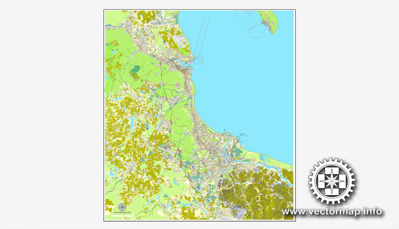
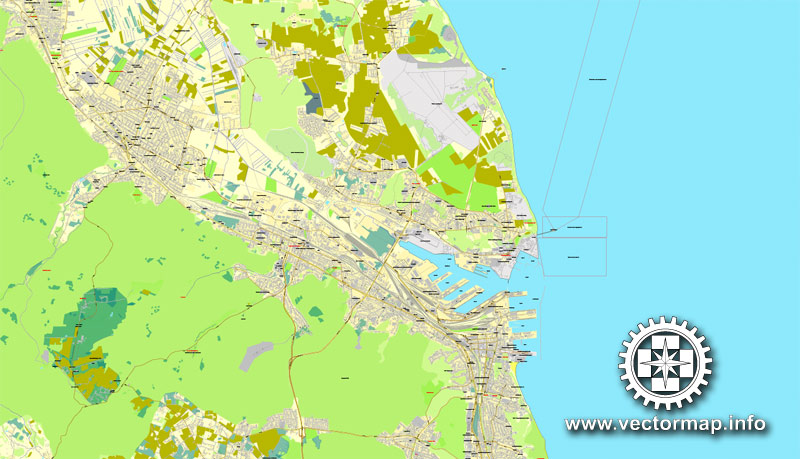
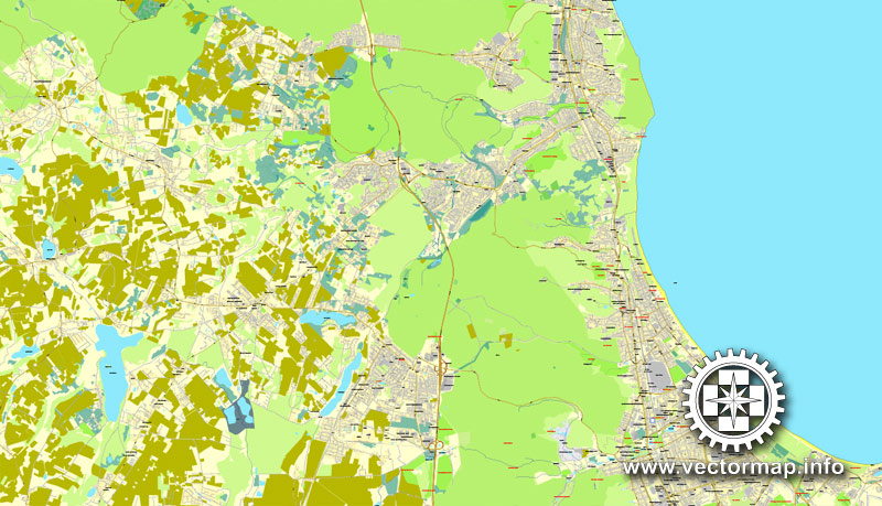
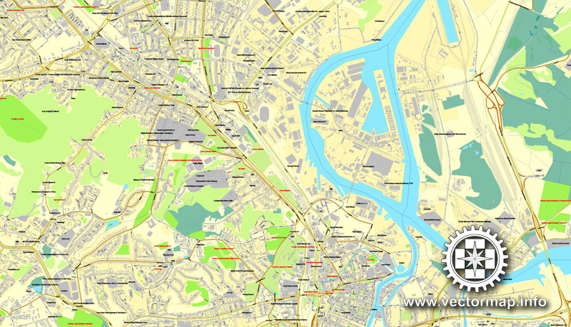
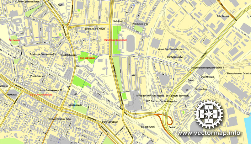
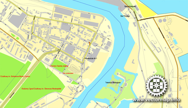
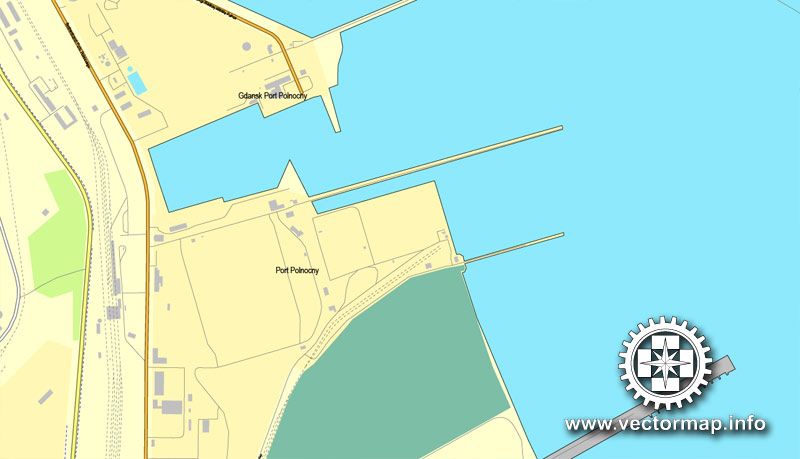
Gdansk + Sopot + Gdynia, Poland, printable vector street map, City Plan, fully editable, Adobe PDF, Royalty free, full vector, scalable, editable, text format of street names, 30 mb ZIP.
All streets, All buildings.
Map for design, print, arts, projects, presentations, for architects, designers and builders.
You can edit this file by Adobe Illustrator, Adobe Acrobat, Corel Draw.
The most accurate and detailed map of the city. Data 2016.
DXF, DWG, CDR and other formats – by request, same price, please contact us.
Gdansk + Sopot + Gdynia, Polska, ulica wektor druku mapa, plan miasta, pełnej edycji, Adobe PDF, Nieodpłatnie pełne wektor, skalowalny edycji, formatowania tekstu nazwy ulic, 30 MB ZIP.
Wszystkie ulice, wszystkie budynki.
Mapa do projektu, druk, sztuki, projekty, prezentacje, dla architektów, projektantów i budowniczych.
PDF, DXF, DWG, CDR i innych formatów – na żądanie, w tej samej cenie, prosimy o kontakt.
See also: TERMS & CONDITIONS: SOFTWARE LICENSE AGREEMENT FOR DIGITAL CARTOGRAPHIC DATA
Gdansk + Gdynia + Sopot, Poland.
This vector map of Gdansk city is used as a basis for design, editing, and further printing.
This is the most detailed, exact map of Gdansk city for high-quality printing and polygraphy. You can always clarify the map development date by contacting us.
For your convenience, all objects on Gdansk vector city map are divided into layers. And the editing is very easy – colors, lines, etc.
You can easily add any objects needed (e.g. shops, salons, sale points, gas station or attraction) on any layer of Gdansk vector map.
Gdańsk is a Polish city on the Baltic coast. It is the capital of the Pomeranian Voivodeship and the capital of Kashubia, Poland’s principal seaport and the centre of the country’s fourth-largest metropolitan area.
One of the advantages of Gdansk city vector maps of our production is the relevance of cartographic data, we constantly update all our products.
This vector map of Gdansk city is used by:
designers, layout designers, printers, advertisers and architects. Our product – vector maps – is designed for further editing and printing in large formats – from @Wall format (a few meters) to A-0 and A-1, A-2, A-3.
The Gdansk city map in vector format is used for design, urban planning, presentations and media visualizations.
The advertising and presentation map of Gdansk city (usually the final designer marks the routes, and puts the client’s objects (shops, saloons, gas stations etc.)
The undoubted advantage is that people will NEVER throw out this advertising product – the map. In fact, as an advertising medium, a city map is the most “long-playing” of the well-known polygraphic advertising media, with the longest lifespan, and the maximum number of interactions with the customer.
For travelers, maps are sold at the airports and gas stations around the world. Often the source is our vector maps.
Take a look, who purchases our vector maps of Gdansk city in “Our Clients and Friends” page – these are large and small companies, from super-brands like Volvo and Starbucks, to small design studios and printing houses.
It’s very easy to work with vector maps of Gdansk city, even for a not very experienced designer who can turn on and off the map layers, add new objects, change the colors of fill and lines according to customer requirements.
The undoubted advantage of Gdansk city vector maps in printing is an excellent and detailed visualization, when customer can expand a large paper map and instantly define his location, find a landmark, an object or address on map, unlike using the popular electronic formats of Google and Yandex maps for example.
Printable vector maps of Gdansk city are much more convenient and efficient than any electronic maps on your smartphone, because ALL DETAILS are displayed in the entire space of Gdansk city map.
The city lies on the southern edge of Gdańsk Bay (of the Baltic Sea), in a conurbation with the city of Gdynia, spa town of Sopot, and suburban communities, which together form a metropolitan area called the Tricity (Trójmiasto), with a population approaching 1.4 million. Gdańsk itself has a population of 464,829 (June 2018), making it the largest city in the Pomerania region of Northern Poland.
Useful tips on working with vector maps of cities and countries in Adobe Illustrator.
«V» – launches the Selection tool (cursor, black arrow), which makes active any vector line.
«А» – launches the Direct Selection tool (white cursor), allows you to select curve elements and drag them to the desired place.
«R» – activates the Rotate tool, which helps you rotating selected objects around the center point by 360 degrees.
«E» – gives you the opportunity to use the Eraser tool and erase unnecessary parts.
«X» – switches between Fill and Stroke in the Tools section. Try to get used to this hot key and
you will quickly understand that you can’t live and work without it.
Guides are not limited to vertical and horizontal in Adobe Illustrator. You can also create a diagonal guide for example. Moreover, you can turn any contours into guides. Select the outline and go to View > Guides > Make Guides (Create Guides), or simply press Cmd/Ctrl + 5. You can also turn the guides back into an editable object. Go to menu, View > Guides > Unlock Guides (Release Guides), select the guide you want to edit and select View > Guides > Release Guides (Reset Guides), or just press Cmd/Ctrl + Option / Alt + 5).
Gdańsk is the capital of Gdańsk Pomerania and the largest city of Kashubia. With its origins as a Polish stronghold erected in the 980s by Mieszko I of Poland, the city’s history is complex, with periods of Polish rule, periods of Prussian or German rule, and periods of autonomy or self-rule as a “free city”. In the early-modern age Gdańsk was a royal city of Poland. It was considered the wealthiest and the largest city of Poland, prior to the 18th century rapid growth of Warsaw. Between the world wars, the Free City of Danzig was in a customs union with Poland and was located between German East Prussia and the so-called Polish Corridor.
You will probably want to change the color scheme used on our Gdansk vector city map.
To quickly and effectively play with colors.
Of course, you can do it manually, all objects in our Gdansk city vector map are divided according to types and layers, and you can easily change the color gamma of vector objects in groups and layers.
But there is more effective way of working with the whole VECTOR MAP of Gdansk city and all layers:
The overview dialog «Edit colors»/«Repaint Graphic Object» (this dialog box name can change depending on the context):
If you have selected a part or a layer of Gdansk city vector map and open the dialog box by clicking the icon in the Control panel, on the Samples palette or the Color Catalog, or if you choose Edit > Edit Colors> Repaint Graphic Object, then the «Repaint Graphic Object» dialog box appears, and you get access to «Assign» and «Edit» tabs.
Gdańsk lies at the mouth of the Motława River, connected to the Leniwka, a branch in the delta of the nearby Vistula River, which drains 60 percent of Poland and connects Gdańsk with the Polish capital, Warsaw. Together with the nearby port of Gdynia, Gdańsk is also a notable industrial center. In the late Middle Ages it was an important seaport and shipbuilding town and, in the 14th and 15th centuries, a member of the Hanseatic League.
If a picture or a map fragment is not selected, and you open the dialog box by clicking the icon in the Control panel, on the Samples palette or in the Color Catalog, the «Edit Colors» dialog box appears and you can only access the «Edit» tab.
Regardless of the name at the top of the dialog box, the right-hand side always displays the color group of the current document, as well as two default color groups: Print Color and Grayscale. These color groups can be selected and used any time.
Create and edit color groups of Gdansk city vector map, and also assign colors using the «Edit Colors»/ а «Repaint Graphic Object» dialog box.
A. Creating and editing of a color group on the «Edit» tab
B. Assigning colors on the «Assign» tab
C. Select a group of colors from the «Color groups» list
The option «Repaint a graphic object» in the lower part of the dialog box allows you to preview the colors on a selected layer of Vector map, or a group of elements, and specify whether its colors will be redefined when the dialog box is closed.
In the interwar period, owing to its multi-ethnic make-up and history, Danzig lay in a disputed region between Poland and the Weimar Republic, and later Nazi Germany. The city’s ambiguous political status was exploited, furthering tension between the two countries, which would ultimately culminate in the Invasion of Poland and the first clash of the Second World War just outside the city limits. In the 1980s it would become the birthplace of the Solidarity movement, which played a major role in bringing an end to Communist rule in Poland and helped precipitate the collapse of the Eastern Bloc, the fall of the Berlin Wall and the dissolution of the Soviet Union.
The main areas of the dialog box are:
«Edit»
The «Edit» tab is designed to create a new or edit the existing color groups.
The harmony rules Menu and the Color Wheel are used to conduct experiments with color harmonies. The color wheel shows how colors are related in color harmony, and the color bars allow you to view and manipulate an individual color values. In addition, you can adjust the brightness, add and remove colors, save color groups and view colors on the selected Vector Map of Gdansk city or a separated layers.
«Assign»
The «Assign» tab is used to view and control on how the original colors are replaced with colors from the color group like your corporate colors in the Vector Map of Gdansk city.
The assign color ability is provided only if the entire map, layer or fragment is selected in the document. You can specify which of new colors replace the current colors, whether the spot colors should be preserved and how colors are replaced (for example, you can replace colors completely or changing the color tone while maintaining the brightness). The «Assign» tab allows you to redefine colors in the Vector Map of Gdansk city, or in separate layers and fragments using the current color group or reducing the number of colors in the current Vector Map.
Color groups
Is a list of all saved color groups for current document (the same groups appear in the «Samples» palette). You can edit and delete the existing color groups, as well as creating a new ones using the list of “Color Groups” in the dialog box. All changes appear in the «Samples» palette.
The highlighted color group shows, which color group is currently edited.
Any color group can be selected and edited, or used to redefine the colors in the selected vector map of Gdansk city, its fragments or elements.
Saving a color group adds this group to the specified list.
Opening the «Edit Colors»/«Repaint Graphic Object» dialog box.
Open the «Edit Colors»/«Repaint Graphic Object» dialog box using one of the following methods:
«Edit»> «Edit Colors»> «Repaint Graphic object» or «Repaint With Style».
Gdańsk is home to the University of Gdańsk, Gdańsk University of Technology, the National Museum, the Gdańsk Shakespeare Theatre, the Museum of the Second World War, Polish Baltic Philharmonic and the European Solidarity Centre. The city also hosts St. Dominic’s Fair, which dates back to 1260, and is regarded as one of the biggest trade and cultural events in Europe.
Use these commands if you need to edit the colors in the selected vector map of Gdansk city.
«Repaint Graphic object» button on the «Control» panel.
Use this button if you need to adjust colors of Gdansk city vector map using the а «Repaint graphic object» dialog box.
The specified button is available if the selected vector map or its fragment contains two or more colors.
Note. This color editing method is convenient for global color adjustment in a vector map, if global colors were not used when creating a City Map of Gdansk.
The «Edit colors» button or «Edit or apply colors» on the «Color Catalog» palette
Click this button if you need to edit colors on the «Color Catalog» palette or edit and then apply them to the selected Vector Map of Gdansk city or its fragment.
The «Edit color group» button or «Edit or apply color group» on the «Samples» palette.
Click this button if you need to edit the colors in the specific color group or edit and apply them to the selected Vector Map of Gdansk city or a group of its elements, for example, the whole layer “Streets and lines”. You can also double-click the color group in the Samples panel to open the dialog box.
If the map file is too large and your computer freezes or even can’t open it quickly:
1. Try to reduce the color resolution of the video card (display) to 256 colors while working with a large map.
2. Using Windows Task Manager, select all the application you don’t need, while working with map, just turn them off.
3. Launch Adobe Illustrator. (DO NOT OPEN the vector map file)
4. Start the Windows Task Manager using administrator rights > Find the “Illustrator” process > set the «real time» priority,
5. Open the file. When you see the LEGACY FONT popup window – click “OK” (do not update). You can restore the TEXT later.
6. Can also be useful: When file is opened – Edit > Settings > Basic Settings > disable smoothing. /// It looks scary, but works quickly)))
We recommend saving the file in Adobe Illustrator 10 version. It’s much more stable when working with VERY BIG size files.
Gdynia is a city in the Pomeranian Voivodeship of Poland and a seaport of Gdańsk Bay on the south coast of the Baltic Sea. Located in Kashubia in Eastern Pomerania, Gdynia is part of a conurbation with the spa town of Sopot, the city of Gdańsk and suburban communities, which together form a metropolitan area called the Tricity (Trójmiasto), with a population of over a million people.
For centuries, Gdynia remained a small farming and fishing village on the Baltic coast. At the beginning of the 20th-century Gdynia became a seaside resort town and experienced an inflow of tourists. This triggered an increase in local population. After Poland regained its independence in 1918, a decision was made to construct a Polish seaport in Gdynia, between the Free City of Danzig (a semi-autonomous city-state under joint League of Nations and Polish administration) and German Pomerania, making Gdynia the primary economic hub of the Polish Corridor. It was then that the town was given a more cosmopolitan character with modernism being the dominant architectural style and emerged as a city in 1926.
The rapid development of Gdynia was interrupted by the outbreak of World War II. The German troops refrained from deliberate bombing. The newly built port and shipyard were completely destroyed during the war. The population of the city suffered much heavier losses as most of the inhabitants were evicted and expelled. The locals were either displaced to other regions of occupied Poland or sent to Nazi concentration camps throughout Europe. After the war, Gdynia was settled with the former inhabitants of Warsaw and lost cities such as Lviv and Vilnius in the Eastern Borderlands. The city was gradually regenerating itself with its shipyard being rebuilt and expanded. In December 1970 the shipyard workers protest against the increase of prices was bloodily repressed. This greatly contributed to the rise of the Solidarity movement in Gdańsk.
Today the port of Gdynia is a regular stopover on the itinerary of luxurious passenger ships and a new ferry terminal with a civil airport are under realisation. The city won numerous awards in relation to safety, infrastructure, quality of life and a rich variety of tourist attractions. In 2013 Gdynia was ranked as Poland’s best city to live in and topped the rankings in the overarching category of general quality of life. Gdynia is also highly noted for its access to education. There are prestigious universities such as the Polish Naval Academy nearby.
Gdynia hosts the Gdynia Film Festival, the main Polish film festival, and was the venue for the International Random Film Festival in 2014.
Districts
Gdynia is divided into smaller divisions: dzielnicas and osiedles. Gdynia’s dzielnicas include: Babie Doły, Chwarzno-Wiczlino, Chylonia, Cisowa, Dąbrowa, Działki Leśne, Grabówek, Kamienna Góra, Karwiny, Leszczynki, Mały Kack, Obłuże, Oksywie, Orłowo, Pogórze, Pustki Cisowskie-Demptowo, Redłowo, Śródmieście, Wielki Kack, Witomino-Leśniczówka, Witomino-Radiostacja, Wzgórze Św. Maksymiliana .
Osiedles: Bernadowo, Brzozowa Góra, Chwarzno, Dąbrówka, Demptowo, Dębowa Góra, Fikakowo, Gołębiewo, Kacze Buki, Kolibki, Kolonia Chwaszczyno, Kolonia Rybacka, Krykulec, Marszewo, Międzytorze, Niemotowo, Osada Kolejowa, Osada Rybacka, Osiedle Bernadowo, Port, Pustki Cisowskie, Tasza, Wiczlino, Wielka Rola, Witomino, Wysoka, Zielenisz.
Sopot is a seaside resort city in Eastern Pomerania on the southern coast of the Baltic Sea in northern Poland, with a population of approximately 40,000.
Sopot is a city with powiat (county) status, in Pomeranian Voivodeship. Until 1999 Sopot was part of the Gdańsk Voivodeship. It lies between the larger cities of Gdańsk to the southeast and Gdynia to the northwest. The three cities together make up the metropolitan area of Tri-City.
Sopot is a major health-spa and tourist resort destination. It has the longest wooden pier in Europe, at 515.5 metres, stretching out into the Bay of Gdańsk. The city is also famous for its Sopot International Song Festival, the largest such event in Europe after the Eurovision Song Contest. Among its other attractions is a fountain of bromide spring water, known as the “inhalation mushroom”.
See more Printable and editable maps of Poland Cities in Adobe PDF and Illustrator
For example: PDF Map Poznan, Poland, printable vector street map
Full Gdansk (Poland) city street vector map Atlas 25 parts
Full Poland printable vector Roadmap
Gdańsk; German: Danzig is a Polish city on the Baltic coast. It is the capital of the Pomeranian Voivodeship, Poland’s principal seaport and is also the centre of the country’s fourth-largest metropolitan area.
The city lies on the southern edge of Gdańsk Bay (of the Baltic Sea), in a conurbation with the city of Gdynia, spa town of Sopot, and suburban communities, which together form a metropolitan area called the Tricity (Trójmiasto), with a population approaching 1.4 million. Gdańsk printable maps itself has a population of 460,427 (December 2012), making it the largest city in the Pomerania region of Northern Poland.
Gdańsk is the capital of Gdańsk Pomerania and the largest city of Kashubia. The city’s history is complex, with periods of Polish rule, periods of Prusso-German rule, and periods of autonomy or self-rule as a “free city”. Between the world wars, the Free City of Danzig was in a customs union with Poland cities vector maps and was located between German East Prussia and the so-called Polish Corridor.
Gdańsk lies at the mouth of the Motława River, connected to the Leniwka, a branch in the delta of the nearby Vistula River, which drains 60 percent of Poland and connects Gdańsk with the Polish capital, Warsaw. Together with the nearby port of Gdynia, Gdańsk is also an important industrial center. In the late Middle Ages it was an important seaport and shipbuilding town, and in the 14th and 15th centuries a member of the Hanseatic League.
In the interwar period, owing to its multi ethnic make-up and history, Gdańsk vector map lay in a disputed region between Poland and the Weimar Republic, and later Nazi Germany. The city’s ambiguous political status was exploited, furthering tension between the two countries, which would ultimately culminate in the Invasion of Poland and the first clash of the Second World War just outside the city limits. In the 1980s it would become the birthplace of the Solidarity movement, which played a major role in bringing an end to Communist rule in Poland and helped precipitate the collapse of the Eastern Bloc, the fall of the Berlin Wall and the dissolution of the Soviet Union.
Source
Gdynia (wymowa i (kasz. Gdiniô, niem. Gdingen[3]) – miasto na prawach powiatu w północnej Polsce, w województwie pomorskim, położone nad Morzem Bałtyckim, na Pobrzeżu Gdańskim i Pojezierzu Wschodniopomorskim. Wchodzi w skład Trójmiasta (wraz z Gdańskiem i Sopotem). Jest jednym z miast aglomeracji Trójmiasta.
Wieś klasztoru kartuzów w Kartuzach w powiecie puckim województwa pomorskiego w II połowie XVI wieku. Prawa miejskie Gdynia mappa uzyskała 4 marca 1926. Impulsem do rozwoju miasta była budowa portu, który powstał w celu zapewnienia Polsce dostępu do morskich szlaków i bazy marynarki wojennej wobec niepewnej sytuacji w Wolnym Mieście Gdańsku. Szybki napływ ludności i dynamiczny rozwój portu sprawiły, że w ciągu kilkunastu lat po nadaniu praw miejskich Gdynia karta ze wsi rybackiej przekształciła się w miasto zamieszkane przez 127 tys. osób (1939).
Według danych z 2015 r. liczy 247 672 mieszkańców, a jej powierzchnia zajmuje 135,14 km² (2012). Jest największym polskim miastem niebędącym miastem wojewódzkim.
Source
Sopot (kaszb. Sopòt lub też Sopòtë, Copòtë, Copòt, niem. Zoppot) – miasto na prawach powiatu w północnej Polsce nad Zatoką Gdańską (Morze Bałtyckie), położone na Pobrzeżu Gdańskim, pomiędzy Gdańskiem i Gdynią, z którymi tworzy Trójmiasto. Jest jednym z miast aglomeracji gdańskiej. Sopot jest najmniejszym pod względem ludności miastem na prawach powiatu w Polsce.
Sopot jest kurortem nadmorskim, miastem uzdrowiskowym, po II wojnie światowej znanym z organizowanych tam od 1961 w Operze Leśnej konkursów piosenki Sopot Festival.
Miasto posiada najdłuższe w Europie molo o drewnianej konstrukcji.
Po reformie administracyjnej w 1999 Sopot w drodze wyjątku otrzymał uprawnienia miasta na prawach powiatu (przysługujące nominalnie miastom o liczbie ludności powyżej 100 tys.). Może także poszczycić się jednym z najniższych w Polsce wskaźników bezrobocia wynoszącym 4,9% (ok. 900 osób).
Wieś Opactwa Cystersów w Oliwie w województwie pomorskim w II połowie XVI wieku.
Source
Small guide: How to work with the vector map?
You can: Mass select objects by type and color – for example, the objects type “building” (they are usually dark gray) – and remove them from the map, if you do not need them in your print or design project. You can also easily change the thickness of lines (streets), just bulk selection the road by the line color.
The streets are separated by type, for example, type “residential road” are usually white with a gray stroke. Highway usually orange with a brown or dark gray stroke.
All objects are divided by types: different types of roads and streets, polygons of buildings, landfills, urban areas, parks and more other.
It is easy to change the font of inscriptions, all or each individually. Also, just can be make and any other manipulation of objects on the vector map in Adobe illustrator format.
Important: All the proportions on the map are true, that is, the relative sizes of the objects are true, because Map is based on an accurate GPS projection, and It transated into the (usual for all) the Mercator projection.
You can easily change the color, stroke and fill of any object on the map, zoom without loss of quality Image Verification.
Select object

Bulk selection the same objects on the vector map

See the bulk selected objects on the vector map

Bulk delete buildungs from the vector map

Select residencial road (small street) on the vector map

Bulk selection the same lines (streets, roads) on the full map

Create fat lines of the streets on the vector maps (bulk action) 1

Create fat lines of the streets on the vector maps (bulk action) 2

Create fat lines of the streets on the vector maps (bulk action) 3

You can easily change the color, stroke and fill of any object on the map, zoom without loss of quality Image Verification.

 Author: Kirill Shrayber, Ph.D. FRGS
 map, V.17.12. fully editable, Adobe Illustrator")
