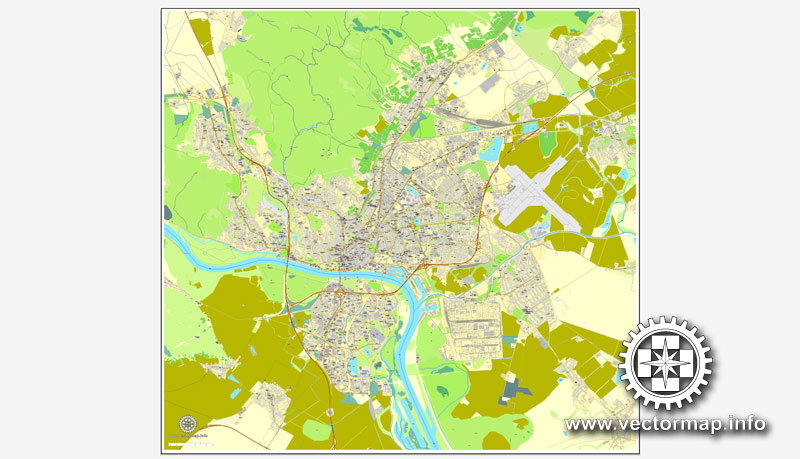
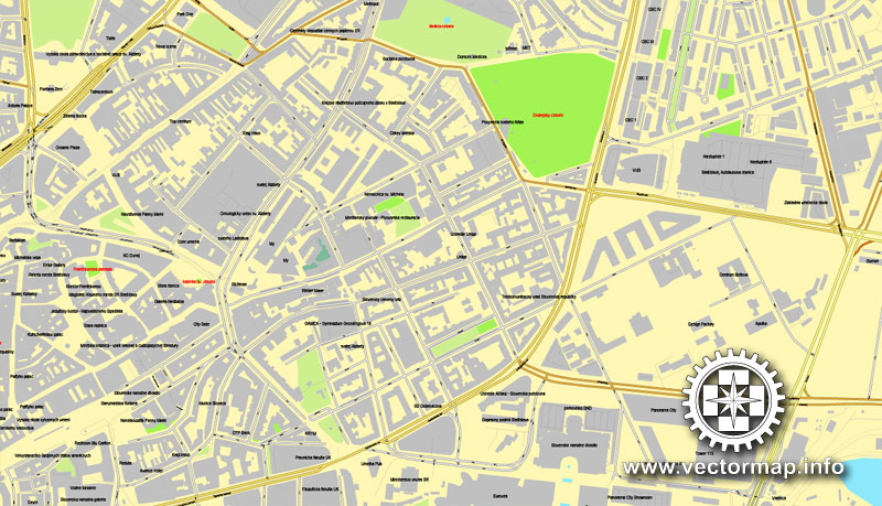
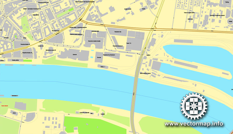
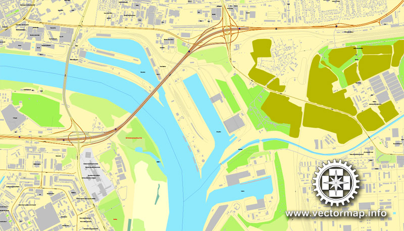
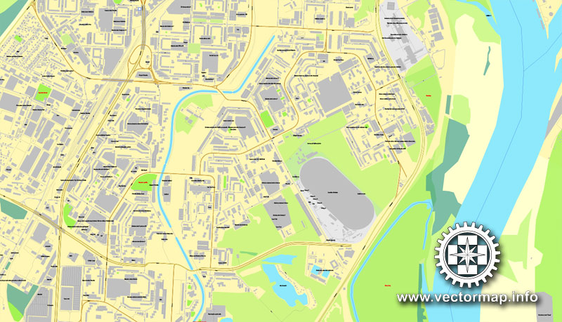
Bratislava, Slovakia, printable vector street map, City Plan, full editable, Adobe PDF, Royalty free, full vector, scalable, editable, text format of street names, 17 Mb ZIP.
All streets, All buildings.
Map for design, print, arts, projects, presentations, for architects, designers and builders.
You can edit this file by Adobe Illustrator, Adobe Acrobat, Corel Draw.
Try turning the display mode VIEW/OUTLINE – you’ll see a lot of interesting things)))
The most accurate and detailed map of the city.
DXF, DWG, CDR and other formats – on request, same price, please, contact
Na vytlačenie mapa Bratislava, Slovensko, vektor ulice, plán mesta, plné editovateľné, Adobe PDF, plná vektora, škálovateľné, editovateľné, text vo formáte názvy ulíc, 17 MB ZIP
Všetky ulice, všetky stavby.
Mapa pre návrh, tlač, umenie, projekty, prezentácie, pre architektov, projektantov a stavebníkov.
DXF, DWG, CDR a ďalšie formáty – na vyžiadanie, za rovnakú cenu, prosím, kontaktujte
Bratislava, Slovakia.
This vector map of Bratislava is used as a basis for design, editing, and further printing.
This is the most detailed, exact map of Bratislava for high-quality printing and polygraphy. You can always clarify the map development date by contacting us.
For your convenience, all objects on Bratislava vector map are divided into layers. And the editing is very easy – colors, lines, etc.
You can easily add any objects needed (e.g. shops, salons, sale points, gas station or attraction) on any layer of Bratislava vector map.
Bratislava is the capital of Slovakia. With a population of about 450,000, it is one of the smaller capitals of Europe but still the country’s largest city. The greater metropolitan area is home to more than 650,000 people. Bratislava is in southwestern Slovakia, occupying both banks of the River Danube and the left bank of the River Morava. Bordering Austria and Hungary, it is the only national capital that borders two sovereign states.
One of the advantages of Bratislava vector maps of our production is the relevance of cartographic data, we constantly update all our products.
This vector map of Bratislava is used by:
designers, layout designers, printers, advertisers and architects. Our product – vector maps – is designed for further editing and printing in large formats – from @Wall format (a few meters) to A-0 and A-1, A-2, A-3.
Bratislava map in vector format is used for design, urban planning, presentations and media visualizations.
Advertising and presentation map of Bratislava (usually the final designer marks the routes, and puts the client’s objects (shops, saloons, gas stations etc.)
The undoubted advantage is that people will NEVER throw out this advertising product – the map. In fact, as an advertising medium, a map is the most “long-playing” of the well-known polygraphic advertising media, with the longest lifespan, and the maximum number of interactions with the customer.
For travelers, maps are sold at the airports and gas stations around the world. Often the source is our vector maps.
The city’s history has been strongly influenced by people of different nations and religions, namely (in alphabetical order) Austrians, Bulgarians, Croats, Czechs, Germans, Hungarians, Jews, Serbs and Slovaks. It was the coronation site and legislative center of the Kingdom of Hungary from 1536 to 1783, and has been home to many Slovak, Hungarian and German historical figures.
Take a look, who purchases our vector maps of Bratislava in “Our Clients and Friends” page – these are large and small companies, from super-brands like Volvo and Starbucks, to small design studios and printing houses.
It’s very easy to work with vector maps of Bratislava, even for a not very experienced designer who can turn on and off the map layers, add new objects, change the colors of fill and lines according to customer requirements.
The undoubted advantage of Bratislava vector maps in printing is an excellent and detailed visualization, when customer can expand a large paper map and instantly define his location, find a landmark, an object or address on map, unlike using the popular electronic formats of Google and Yandex maps for example.
Printable vector maps of Bratislava are much more convenient and efficient than any electronic maps on your smartphone, because ALL DETAILS are displayed in the entire space of Bratislava map.
Bratislava is the political, cultural and economic centre of Slovakia. It is the seat of the Slovak president, the parliament and the Slovak Executive. It has several universities, and many museums, theatres, galleries and other cultural and educational institutions. Many of Slovakia’s large businesses and financial institutions have headquarters there.
Useful tips on working with vector maps of cities and countries in Adobe Illustrator.
«V» – launches the Selection tool (cursor, black arrow), which makes active any vector line.
«А» – launches the Direct Selection tool (white cursor), allows you to select curve elements and drag them to the desired place.
«R» – activates the Rotate tool, which helps you rotating selected objects around the center point by 360 degrees.
«E» – gives you the opportunity to use the Eraser tool and erase unnecessary parts.
«X» – switches between Fill and Stroke in the Tools section. Try to get used to this hot key and
you will quickly understand that you can’t live and work without it.
Guides are not limited to vertical and horizontal in Adobe Illustrator. You can also create a diagonal guide for example. Moreover, you can turn any contours into guides. Select the outline and go to View > Guides > Make Guides (Create Guides), or simply press Cmd/Ctrl + 5. You can also turn the guides back into an editable object. Go to menu, View > Guides > Unlock Guides (Release Guides), select the guide you want to edit and select View > Guides > Release Guides (Reset Guides), or just press Cmd/Ctrl + Option / Alt + 5).
Bratislava, the capital city of Slovakia, is situated in Central Europe and it is located in the extreme south-west within Slovakia. The city borders Austria in the west and Hungary in the south making it the only national capital in the world to border two foreign countries. State border with the Czech Republic is only 62 kilometres (38.5 mi) distant. Bratislava lies on the foothills of the Little Carpathians mountains and the city straddles both banks of the Danube River. The city has a total area of 367.58 square kilometres (141.9 mi²), making it the second largest city in Slovakia by area (after the township of Vysoké Tatry). Geomorphologically the city covers the southern tip of the Záhorie Lowland, the entire range of the Devín Carpathians, small westernmost part of the Pezinok Carpahians and the northern tip of the Danubian Lowland.
You will probably want to change the color scheme used on our Bratislava vector map.
To quickly and effectively play with colors.
Of course, you can do it manually, all objects in our Bratislava vector map are divided according to types and layers, and you can easily change the color gamma of vector objects in groups and layers.
But there is more effective way of working with the whole VECTOR MAP of Bratislava and all layers:
The overview dialog «Edit colors»/«Repaint Graphic Object» (this dialog box name can change depending on the context):
If you have selected a part or a layer of Bratislava vector map and open the dialog box by clicking the icon in the Control panel, on the Samples palette or the Color Catalog, or if you choose Edit > Edit Colors> Repaint Graphic Object, then the «Repaint Graphic Object» dialog box appears, and you get access to «Assign» and «Edit» tabs.
If a picture or a map fragment is not selected, and you open the dialog box by clicking the icon in the Control panel, on the Samples palette or in the Color Catalog, the «Edit Colors» dialog box appears and you can only access the «Edit» tab.
Regardless of the name at the top of the dialog box, the right-hand side always displays the color group of the current document, as well as two default color groups: Print Color and Grayscale. These color groups can be selected and used any time.
Create and edit color groups of Bratislava vector map, and also assign colors using the «Edit Colors»/ а «Repaint Graphic Object» dialog box.
A. Creating and editing of a color group on the «Edit» tab
B. Assigning colors on the «Assign» tab
C. Select a group of colors from the «Color groups» list
The option «Repaint a graphic object» in the lower part of the dialog box allows you to preview the colors on a selected layer of Vector map, or a group of elements, and specify whether its colors will be redefined when the dialog box is closed.
The main areas of the dialog box are:
«Edit»
The «Edit» tab is designed to create a new or edit the existing color groups.
The harmony rules Menu and the Color Wheel are used to conduct experiments with color harmonies. The color wheel shows how colors are related in color harmony, and the color bars allow you to view and manipulate an individual color values. In addition, you can adjust the brightness, add and remove colors, save color groups and view colors on the selected Vector Map of Bratislava or a separated layers.
«Assign»
The «Assign» tab is used to view and control on how the original colors are replaced with colors from the color group like your corporate colors in the Vector Map of Bratislava.
The assign color ability is provided only if the entire map, layer or fragment is selected in the document. You can specify which of new colors replace the current colors, whether the spot colors should be preserved and how colors are replaced (for example, you can replace colors completely or changing the color tone while maintaining the brightness). The «Assign» tab allows you to redefine colors in the Vector Map of Bratislava, or in separate layers and fragments using the current color group or reducing the number of colors in the current Vector Map.
Color groups
Is a list of all saved color groups for current document (the same groups appear in the «Samples» palette). You can edit and delete the existing color groups, as well as creating a new ones using the list of “Color Groups” in the dialog box. All changes appear in the «Samples» palette.
The highlighted color group shows, which color group is currently edited.
Any color group can be selected and edited, or used to redefine the colors in the selected vector map of Bratislava, its fragments or elements.
Saving a color group adds this group to the specified list.
Opening the «Edit Colors»/«Repaint Graphic Object» dialog box.
Open the «Edit Colors»/«Repaint Graphic Object» dialog box using one of the following methods:
«Edit»> «Edit Colors»> «Repaint Graphic object» or «Repaint With Style».
Use these commands if you need to edit the colors in the selected vector map of Bratislava.
«Repaint Graphic object» button on the «Control» panel.
Use this button if you need to adjust colors of Bratislava vector map using the а «Repaint graphic object» dialog box.
The specified button is available if the selected vector map or its fragment contains two or more colors.
Note. This color editing method is convenient for global color adjustment in a vector map, if global colors were not used when creating a Map of Bratislava.
The «Edit colors» button or «Edit or apply colors» on the «Color Catalog» palette
Click this button if you need to edit colors on the «Color Catalog» palette or edit and then apply them to the selected Vector Map of Bratislava or its fragment.
The «Edit color group» button or «Edit or apply color group» on the «Samples» palette.
Click this button if you need to edit the colors in the specific color group or edit and apply them to the selected Vector Map of Bratislava or a group of its elements, for example, the whole layer “Streets and lines”. You can also double-click the color group in the Samples panel to open the dialog box.
If the map file is too large and your computer freezes or even can’t open it quickly:
1. Try to reduce the color resolution of the video card (display) to 256 colors while working with a large map.
2. Using Windows Task Manager, select all the application you don’t need, while working with map, just turn them off.
3. Launch Adobe Illustrator. (DO NOT OPEN the vector map file)
4. Start the Windows Task Manager using administrator rights > Find the “Illustrator” process > set the «real time» priority,
5. Open the file. When you see the LEGACY FONT popup window – click “OK” (do not update). You can restore the TEXT later.
6. Can also be useful: When file is opened – Edit > Settings > Basic Settings > disable smoothing. /// It looks scary, but works quickly)))
We recommend saving the file in Adobe Illustrator 10 version. It’s much more stable when working with VERY BIG size files.
The Danube crosses the city from the west to the south-east. The Middle Danube basin begins at Devín Gate in western Bratislava. Other rivers nearby are the Morava River, which forms the north-western border of the city and flows into the Danube at Devín, the Little Danube, and the Vydrica, which flows into the Danube at the borough of Karlova Ves. Some parts of Bratislava, particularly Devín and Devínska Nová Ves, are vulnerable to floods. New flood protection is being built on both banks.
The Carpathian mountain range begins in city territory with the Little Carpathians (Malé Karpaty). The area includes Bratislava Forest Park, which is popular with many Bratislavans and is part of the Little Carpathians Protected Landscape Area. The city’s lowest point is at the Danube’s surface, at 126 metres (413.4 ft) above mean sea level, and the highest point is Devínska Kobyla at 514 metres (1686.3 ft). The average altitude is 140 metres (459.3 ft). The Záhorie and Danubian Lowlands are partly situated in the city.
The nearest towns and villages are: to the north Stupava, Borinka and Svätý Jur; to the east Ivanka pri Dunaji and Most pri Bratislave; to the south-east Rovinka, Dunajská Lužná and Šamorín; to the south Rajka (HU); and to the west Kittsee (AT), Hainburg an der Donau (AT) and Marchegg (AT).
Distances from selected European cities
Bratislava is situated: 62 km from Vienna; 196 km from Budapest; 324 km from Prague; 532 km from Warsaw; 569 km from Belgrade; 769 km from Zürich; 1005 km from Kiev; 1266 km from Paris; 1273 km from Amsterdam; 1314 km from Rome; 1473 km from Istanbul; 1602 km from London; 1735 km from Stockholm; 1886 km from Athens; 2104 km from Moscow and 2261 km from Madrid.
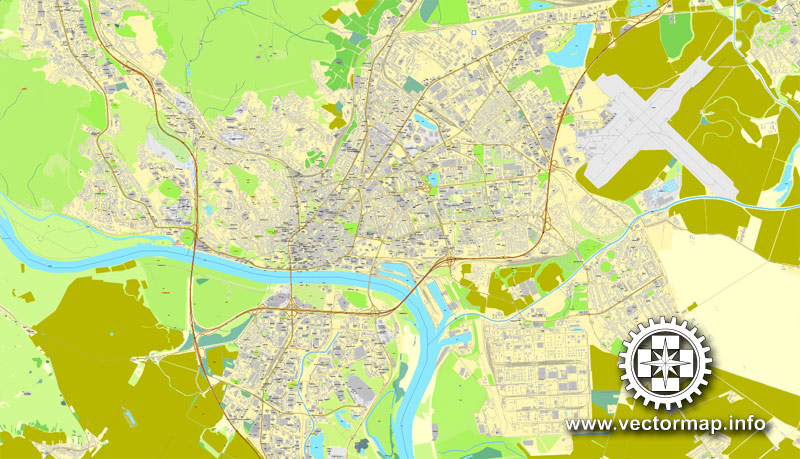
See more Slovakia vector maps
For example: Printable Map Bratislava metro area, Slovakia
Bratislava is the capital of Slovakia, and with a population of about 450,000, the country’s largest city. The greater metropolitan area is home to more than 650,000 people. Bratislava is in southwestern Slovakia, occupying both banks of the River Danube and the left bank of the River Morava. Bordering Austria and Hungary, it is the only national capital that borders two sovereign states.
Bratislava is the political, cultural and economic centre of Slovakia. It is the seat of the Slovak president, the parliament and the Slovak Executive. It is home to several universities, museums, theatres, galleries and other important cultural and educational institutions. Many of Slovakia’s large businesses and financial institutions also have headquarters there. Bratislava vector map is the sixth richest region of the European Union and GDP per capita is about three times higher than in other Slovak regions.
The history of the city has been strongly influenced by people of different nations and religions, namely by Austrians, Croats, Czechs, Germans, Hungarians, Jews, Serbs and Slovaks (in alphabetical order). The city was the capital of the Kingdom of Hungary, a part of the larger Habsburg Monarchy territories, from 1536 to 1783 and has been home to many Slovak, Hungarian and German historical figures.
Bratislava is situated in south-western Slovakia, within the Bratislava Region. Its location on the borders with Austria and Hungary makes it the only national capital that borders between two countries. It is only 62 kilometres (38.5 mi) from the border with the Czech Republic and only 60 kilometres (37.3 mi) from the Austrian capital Vienna.
The city has a total area of 367.58 square kilometres (141.9 sq mi), making it the second-largest city in Slovakia by area (after the township of Vysoké Tatry). Bratislava map straddles the Danube River, which it had developed around and for centuries was the chief transportation route to other areas. The river passes through the city from the west to the south-east. The Middle Danube basin begins at Devín Gate in western Bratislava. Other rivers are the Morava River, which forms the north-western border of the city and enters the Danube at Devín, the Little Danube, and the Vydrica, which enters the Danube in the borough of Karlova Ves.
The Carpathian mountain range begins in city territory with the Little Carpathians (Malé Karpaty). The Záhorie and Danubian lowlands stretch into Bratislava. The city’s lowest point is at the Danube’s surface at 126 metres (413 ft) above mean sea level, and the highest point is Devínska Kobyla at 514 metres (1,686 ft). The average altitude is 140 metres (460 ft).
Geography of Bratislava
From Wikipedia, the free encyclopedia
Bratislava is situated in the extreme south-west of Slovakia
Bratislava, the capital city of Slovakia, is situated in the central Europe and in the south-west within Slovakia. Its location at the borders of Austria in the west and Hungary in the south makes it the only national capital in the world that borders two countries. It is only 62 kilometres (38.5 mi) from the border with the Czech Republic and only 60 kilometres (37.3 mi) from the Austrian capital Vienna.
The city has a total area of 367.58 square kilometres (141.9 mi²), making it the second largest city in Slovakia by area (after the township of Vysoké Tatry). Bratislava straddles both banks of the Danube River, which crosses the city from the west to the south-east. The Middle Danube basin begins at Devín Gate in western Bratislava. Other rivers nearby are the Morava River, which forms the north-western border of the city and flows into the Danube at Devín, the Little Danube, and the Vydrica, which flows into the Danube at the borough of Karlova Ves. Some parts of Bratislava city map, particularly Devín and Devínska Nová Ves, are vulnerable to floods. New flood protection is being built on both banks.
Bratislava’s highest point, Devínska Kobyla, as seen from Devín
The Carpathian mountain range begins in city territory with the Little Carpathians (Malé Karpaty). The area includes Bratislava Forest Park, which is popular with many Bratislavans and is part of the Little Carpathians Protected Landscape Area. The city’s lowest point is at the Danube’s surface, at 126 metres (413.4 ft) above mean sea level, and the highest point is Devínska Kobyla at 514 metres (1686.3 ft). The average altitude is 140 metres (459.3 ft). The Záhorie and Danubian Lowlands are partly situated in the city.
The nearest towns and villages are: to the north Stupava, Borinka and Svätý Jur; to the east Ivanka pri Dunaji and Most pri Bratislave; to the south-east Rovinka, Dunajská Lužná and Šamorín; to the south Rajka (HU); and to the west Kittsee (AT), Hainburg an der Donau (AT) and Marchegg (AT).
Selected distances from certain European cities
Bratislava is situated: 62 km from Vienna; 196 km from Budapest; 324 km from Prague; 569 km from Belgrade; 769 km from Zürich; 1266 km from Paris; 1273 km from Amsterdam; 1314 km from Rome; 1473 km from Istanbul; 1602 km from London; 1735 km from Stockholm; 1886 km from Athens; 2104 km from Moscow and 2261 km from Madrid.
Source
Small guide: How to work with the vector map?
You can: Mass select objects by type and color – for example, the objects type “building” (they are usually dark gray) – and remove them from the map, if you do not need them in your print or design project. You can also easily change the thickness of lines (streets), just bulk selection the road by the line color.
The streets are separated by type, for example, type “residential road” are usually white with a gray stroke. Highway usually orange with a brown or dark gray stroke.
All objects are divided by types: different types of roads and streets, polygons of buildings, landfills, urban areas, parks and more other.
It is easy to change the font of inscriptions, all or each individually. Also, just can be make and any other manipulation of objects on the vector map in Adobe illustrator format.
Important: All the proportions on the map are true, that is, the relative sizes of the objects are true, because Map is based on an accurate GPS projection, and It transated into the (usual for all) the Mercator projection.
You can easily change the color, stroke and fill of any object on the map, zoom without loss of quality Image Verification.
Select object

Bulk selection the same objects on the vector map

See the bulk selected objects on the vector map

Bulk delete buildungs from the vector map

Select residencial road (small street) on the vector map

Bulk selection the same lines (streets, roads) on the full map

Create fat lines of the streets on the vector maps (bulk action) 1

Create fat lines of the streets on the vector maps (bulk action) 2

Create fat lines of the streets on the vector maps (bulk action) 3

You can easily change the color, stroke and fill of any object on the map, zoom without loss of quality Image Verification.


 Author: Kirill Shrayber, Ph.D. FRGS
 map, V.12.12. fully editable, Adobe Illustrator")
