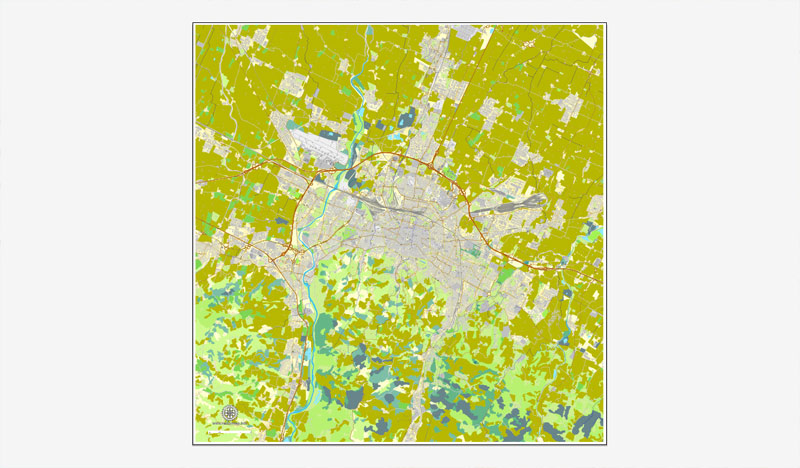
Bologna, Italy, printable vector street map City Plan, full editable, Adobe PDF, Royalty free, full vector, scalable, editable, text format street names, 20 mb ZIP
All streets, All buildings.
Map for design, print, arts, projects, presentations, for architects, designers and builders.
The most accurate and detailed map of the city.
You can edit this file by Adobe Illustrator, Adobe Acrobat, Corel Draw.
DXF, DWG, CDR and other formats – on request, same price, please, contact
Bologna, Italy.
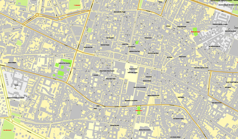
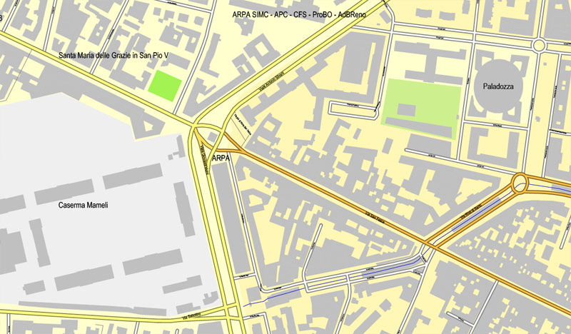
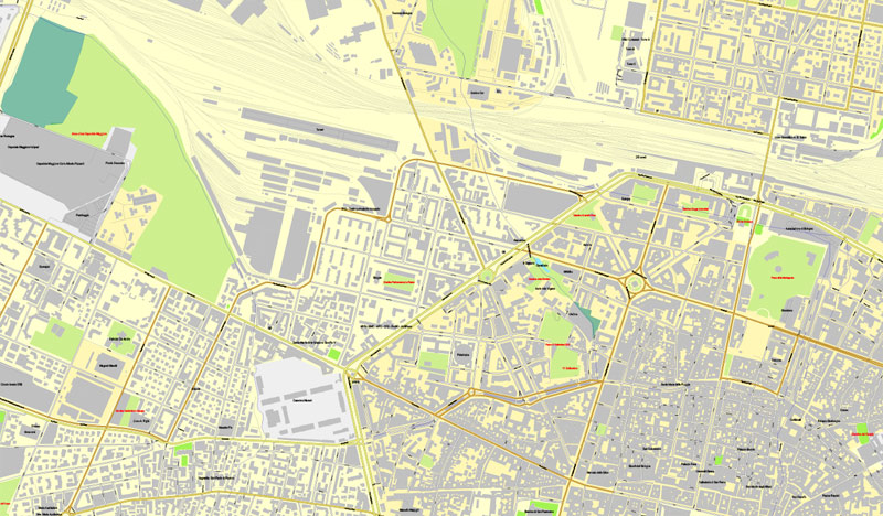
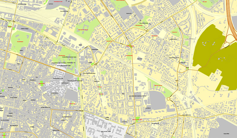
This vector map of Bologna is used as a basis for design, editing, and further printing.
This is the most detailed, exact map of Bologna for high-quality printing and polygraphy. You can always clarify the map development date by contacting us.
For your convenience, all objects on Bologna vector map are divided into layers. And the editing is very easy – colors, lines, etc.
You can easily add any objects needed (e.g. shops, salons, sale points, gas station or attraction) on any layer of Bologna vector map.
Bologna is the capital and largest city of the Emilia-Romagna Region in Northern Italy. It is the seventh most populous city in Italy, at the heart of a metropolitan area of about one million people.
One of the advantages of Bologna vector maps of our production is the relevance of cartographic data, we constantly update all our products.
This vector map of Bologna is used by:
designers, layout designers, printers, advertisers and architects. Our product – vector maps – is designed for further editing and printing in large formats – from @Wall format (a few meters) to A-0 and A-1, A-2, A-3.
Bologna map in vector format is used for design, urban planning, presentations and media visualizations.
Advertising and presentation map of Bologna (usually the final designer marks the routes, and puts the client’s objects (shops, saloons, gas stations etc.)
The undoubted advantage is that people will NEVER throw out this advertising product – the map. In fact, as an advertising medium, a map is the most “long-playing” of the well-known polygraphic advertising media, with the longest lifespan, and the maximum number of interactions with the customer.
For travelers, maps are sold at the airports and gas stations around the world. Often the source is our vector maps.
Take a look, who purchases our vector maps of Bologna in “Our Clients and Friends” page – these are large and small companies, from super-brands like Volvo and Starbucks, to small design studios and printing houses.
It’s very easy to work with vector maps of Bologna, even for a not very experienced designer who can turn on and off the map layers, add new objects, change the colors of fill and lines according to customer requirements.
The undoubted advantage of Bologna vector maps in printing is an excellent and detailed visualization, when customer can expand a large paper map and instantly define his location, find a landmark, an object or address on map, unlike using the popular electronic formats of Google and Yandex maps for example.

Printable vector maps of Bologna are much more convenient and efficient than any electronic maps on your smartphone, because ALL DETAILS are displayed in the entire space of Bologna map.
Useful tips on working with vector maps of cities and countries in Adobe Illustrator.
«V» – launches the Selection tool (cursor, black arrow), which makes active any vector line.
«А» – launches the Direct Selection tool (white cursor), allows you to select curve elements and drag them to the desired place.
«R» – activates the Rotate tool, which helps you rotating selected objects around the center point by 360 degrees.
«E» – gives you the opportunity to use the Eraser tool and erase unnecessary parts.
«X» – switches between Fill and Stroke in the Tools section. Try to get used to this hot key and
you will quickly understand that you can’t live and work without it.
Guides are not limited to vertical and horizontal in Adobe Illustrator. You can also create a diagonal guide for example. Moreover, you can turn any contours into guides. Select the outline and go to View > Guides > Make Guides (Create Guides), or simply press Cmd/Ctrl + 5. You can also turn the guides back into an editable object. Go to menu, View > Guides > Unlock Guides (Release Guides), select the guide you want to edit and select View > Guides > Release Guides (Reset Guides), or just press Cmd/Ctrl + Option / Alt + 5).
You will probably want to change the color scheme used on our Bologna vector map.
To quickly and effectively play with colors.
Of course, you can do it manually, all objects in our Bologna vector map are divided according to types and layers, and you can easily change the color gamma of vector objects in groups and layers.
But there is more effective way of working with the whole VECTOR MAP of Bologna and all layers:
The overview dialog «Edit colors»/«Repaint Graphic Object» (this dialog box name can change depending on the context):
If you have selected a part or a layer of Bologna vector map and open the dialog box by clicking the icon in the Control panel, on the Samples palette or the Color Catalog, or if you choose Edit > Edit Colors> Repaint Graphic Object, then the «Repaint Graphic Object» dialog box appears, and you get access to «Assign» and «Edit» tabs.
If a picture or a map fragment is not selected, and you open the dialog box by clicking the icon in the Control panel, on the Samples palette or in the Color Catalog, the «Edit Colors» dialog box appears and you can only access the «Edit» tab.
Regardless of the name at the top of the dialog box, the right-hand side always displays the color group of the current document, as well as two default color groups: Print Color and Grayscale. These color groups can be selected and used any time.
Of Etruscan origin, the city has been a major urban centre for centuries, first under the Etruscans, then under the Romans (Bononia), then again in the Middle Ages, as a free municipality and signoria, when it was among the largest European cities by population. Famous for its towers, churches and lengthy porticoes, Bologna has a well-preserved historical centre, thanks to a careful restoration and conservation policy which began at the end of the 1970s. Home to the oldest university in the world, the University of Bologna, established in AD 1088, the city has a large student population that gives it a cosmopolitan character. In 2000 it was declared European capital of culture and in 2006, a UNESCO “City of Music” and became part of the Creative Cities Network.

Create and edit color groups of Bologna vector map, and also assign colors using the «Edit Colors»/ а «Repaint Graphic Object» dialog box.
A. Creating and editing of a color group on the «Edit» tab
B. Assigning colors on the «Assign» tab
C. Select a group of colors from the «Color groups» list
The option «Repaint a graphic object» in the lower part of the dialog box allows you to preview the colors on a selected layer of Vector map, or a group of elements, and specify whether its colors will be redefined when the dialog box is closed.
The main areas of the dialog box are:
«Edit»
The «Edit» tab is designed to create a new or edit the existing color groups.
The harmony rules Menu and the Color Wheel are used to conduct experiments with color harmonies. The color wheel shows how colors are related in color harmony, and the color bars allow you to view and manipulate an individual color values. In addition, you can adjust the brightness, add and remove colors, save color groups and view colors on the selected Vector Map of Bologna or a separated layers.
«Assign»
The «Assign» tab is used to view and control on how the original colors are replaced with colors from the color group like your corporate colors in the Vector Map of Bologna.
The assign color ability is provided only if the entire map, layer or fragment is selected in the document. You can specify which of new colors replace the current colors, whether the spot colors should be preserved and how colors are replaced (for example, you can replace colors completely or changing the color tone while maintaining the brightness). The «Assign» tab allows you to redefine colors in the Vector Map of Bologna, or in separate layers and fragments using the current color group or reducing the number of colors in the current Vector Map.
Color groups
Is a list of all saved color groups for current document (the same groups appear in the «Samples» palette). You can edit and delete the existing color groups, as well as creating a new ones using the list of “Color Groups” in the dialog box. All changes appear in the «Samples» palette.
The highlighted color group shows, which color group is currently edited.

Any color group can be selected and edited, or used to redefine the colors in the selected vector map of Bologna, its fragments or elements.
Saving a color group adds this group to the specified list.
Opening the «Edit Colors»/«Repaint Graphic Object» dialog box.
Open the «Edit Colors»/«Repaint Graphic Object» dialog box using one of the following methods:
«Edit»> «Edit Colors»> «Repaint Graphic object» or «Repaint With Style».
Use these commands if you need to edit the colors in the selected vector map of Bologna.
«Repaint Graphic object» button on the «Control» panel.
Use this button if you need to adjust colors of Bologna vector map using the а «Repaint graphic object» dialog box.
The specified button is available if the selected vector map or its fragment contains two or more colors.
Note. This color editing method is convenient for global color adjustment in a vector map, if global colors were not used when creating a Map of Bologna.
The «Edit colors» button or «Edit or apply colors» on the «Color Catalog» palette
Click this button if you need to edit colors on the «Color Catalog» palette or edit and then apply them to the selected Vector Map of Bologna or its fragment.
The «Edit color group» button or «Edit or apply color group» on the «Samples» palette.
Click this button if you need to edit the colors in the specific color group or edit and apply them to the selected Vector Map of Bologna or a group of its elements, for example, the whole layer “Streets and lines”. You can also double-click the color group in the Samples panel to open the dialog box.
If the map file is too large and your computer freezes or even can’t open it quickly:
1. Try to reduce the color resolution of the video card (display) to 256 colors while working with a large map.
2. Using Windows Task Manager, select all the application you don’t need, while working with map, just turn them off.
3. Launch Adobe Illustrator. (DO NOT OPEN the vector map file)
4. Start the Windows Task Manager using administrator rights > Find the “Illustrator” process > set the «real time» priority,
5. Open the file. When you see the LEGACY FONT popup window – click “OK” (do not update). You can restore the TEXT later.
6. Can also be useful: When file is opened – Edit > Settings > Basic Settings > disable smoothing. /// It looks scary, but works quickly)))
We recommend saving the file in Adobe Illustrator 10 version. It’s much more stable when working with VERY BIG size files.
Bologna is an important agricultural, industrial, financial and transport hub, where many large mechanical, electronic and food companies have their headquarters as well as one of the largest permanent trade fairs in Europe. According to the most recent data gathered by the European Regional Economic Growth Index (E-REGI) of 2009, Bologna is the first Italian city and the 47th European city in terms of its economic growth rate. As a consequence, Bologna is also one of the wealthiest cities in Italy, often ranking as one of the top cities in terms of quality of life in the country: in 2011 it ranked 1st out of 107 Italian cities.
Territory
Bologna is situated on the edge of the Po Plain at the foot of the Apennine Mountains, at the meeting of the Reno and Savena river valleys. As Bologna’s two main watercourses flow directly to the sea, the town lies outside of the drainage basin of the River Po. The Province of Bologna stretches from the western edge of the Po Plain on the border with Ferrara to the Tuscan-Emilian Apennines. The centre of the town is 54 metres (177 ft) above sea level (while elevation within the municipality ranges from 29 metres (95 ft) in the suburb of Corticella to 300 metres (980 ft) in Sabbiuno and the Colle della Guardia). The Province of Bologna stretches from the Po Plain into the Apennines; the highest point in the province is the peak of Corno alle Scale (in Lizzano in Belvedere) at 1,945 metres (6,381 ft) above sea level.
Bologna
City in Italy
Bologna is the lively, historic capital of the Emilia-Romagna region, in northern Italy. Piazza Maggiore is a sprawling plaza lined with arched colonnades, cafes and medieval and Renaissance structures, such as City Hall, the Neptune Fountain and the Basilica of San Petronio. Among several medieval towers is the leaning Asinelli Tower, which is open for climbs.
Population: 375,893 (2012) UNdata
Province: Province of Bologna
Bologna is the largest city (and the capital) of the Emilia-Romagna Region in Italy. It is the seventh most populous city in Italy, located in the heart of a metropolitan area (officially recognized by the Italian government as a città metropolitana) of about one million.
The first settlements date back to at least 1000 BC. The city has been an urban centre, first under the Etruscans (Velzna/Felsina) and the Celts (Bona), then under the Romans (Bononia), then again in the Middle Ages, as a free municipality (for one century it was the fifth largest European city based on population). Home to the oldest university in the world, University of Bologna, founded in 1088, Bologna hosts thousands of students who enrich the social and cultural life of the city. Famous for its towers and lengthy porticoes, Bologna has a well-preserved historical centre (one of the largest in Italy) thanks to a careful restoration and conservation policy which began at the end of the 1970s, on the heels of serious damage done by the urban demolition at the end of the 19th century as well as that caused by wars.
An important cultural and artistic centre, its importance in terms of landmarks can be attributed to a varied mixture of monuments and architectural examples (medieval towers, antique buildings, churches, the layout of its historical centre) as well as works of art which are the result of a first class architectural and artistic history. Bologna is also an important transportation crossroad for the roads and trains of Northern Italy, where many important mechanical, electronic and nutritional industries have their headquarters. According to the most recent data gathered by the European Regional Economic Growth Index (E-REGI) of 2009, Bologna is the first Italian city and the 47th European city in terms of its economic growth rate.
Bologna is home to numerous prestigious cultural, economic and political institutions as well as one of the most impressive trade fair districts in Europe. In 2000 it was declared European capital of culture and in 2006, a UNESCO “city of music”. The city of Bologna was selected to participate in the Universal Exposition of Shanghai 2010 together with 45 other cities from around the world. Bologna is also one of the wealthiest cities in Italy, often ranking as one of the top cities in terms of quality of life in the country: in 2011 it ranked 1st out of 107 Italian cities.
Small guide: How to work with the vector map?
You can: Mass select objects by type and color – for example, the objects type “building” (they are usually dark gray) – and remove them from the map, if you do not need them in your print or design project. You can also easily change the thickness of lines (streets), just bulk selection the road by the line color.
The streets are separated by type, for example, type “residential road” are usually white with a gray stroke. Highway usually orange with a brown or dark gray stroke.
All objects are divided by types: different types of roads and streets, polygons of buildings, landfills, urban areas, parks and more other.
It is easy to change the font of inscriptions, all or each individually. Also, just can be make and any other manipulation of objects on the vector map in Adobe illustrator format.
Important: All the proportions on the map are true, that is, the relative sizes of the objects are true, because Map is based on an accurate GPS projection, and It transated into the (usual for all) the Mercator projection.
You can easily change the color, stroke and fill of any object on the map, zoom without loss of quality Image Verification.
Select object

Bulk selection the same objects on the vector map

See the bulk selected objects on the vector map

Bulk delete buildungs from the vector map

Select residencial road (small street) on the vector map

Bulk selection the same lines (streets, roads) on the full map

Create fat lines of the streets on the vector maps (bulk action) 1

Create fat lines of the streets on the vector maps (bulk action) 2

Create fat lines of the streets on the vector maps (bulk action) 3

You can easily change the color, stroke and fill of any object on the map, zoom without loss of quality Image Verification.

 Author: Kirill Shrayber, Ph.D. FRGS

