About Barcelona (Spain, Europe) vector map in Adobe Illustrator (*.AI) Atlas 25 parts, and other formats
Looking for high quality vector maps of Barcelona, Spain? The lowest cost of the market, only in VectorMap.info
Archive format: .AI (Adobe Illustrator), also can be purchased in other formats for the same price: DWG, DXF AutoCAD, Corel Draw, EPS, PDF.
Barcelona vectorial map archive size: 31 Mb
License: Royalty Free, You do not need to pay for each use or per volume sold.
Barcelona vector map data: 2015
DPI: 300
Best for art projects, presentations or posters.
This Barcelona vector map is a poster-sized layered map, which can be edited in just all vector programs and adjusted to any size with no quality loss.
Please, contact us if you want some special objects to be added on this Barcelona vector maps. No extra cost, of course.
Our Barcelona AI map features:
Highways with names,
Major streets with names,
Major Roads,
Pipeline,
National Park Borders,
Airports,
Railway lines with stops,
Latitude and Longitude data,
Minor Roads,
Private Roads,
Cemeteries,
Big and small Rivers, small streams also,
Lake, ponds and other water bodies,
Landmark fill,
Recreation zones,
County Borders with fill,
Sidewalk/Walkway/Pedestrian roads,
Power Lines,
Parks.
Barcelona, Spain.
This vector map of Barcelona city is used as a basis for design, editing, and further printing.
This is the most detailed, exact map of Barcelona city for high-quality printing and polygraphy. You can always clarify the map development date by contacting us.
For your convenience, all objects on Barcelona vector city map are divided into layers. And the editing is very easy – colors, lines, etc.
You can easily add any objects needed (e.g. shops, salons, sale points, gas station or attraction) on any layer of Barcelona vector map.
Barcelona is a city in Spain. It is the capital and largest city of Catalonia, as well as the second most populous municipality of Spain. With a population of 1.6 million within city limits, its urban area extends to numerous neighbouring municipalities within the Province of Barcelona and is home to around 4.8 million people, making it the sixth most populous urban area in the European Union after Paris, London, Madrid, the Ruhr area and Milan. It is one of the largest metropolises on the Mediterranean Sea, located on the coast between the mouths of the rivers Llobregat and Besòs, and bounded to the west by the Serra de Collserola mountain range, the tallest peak of which is 512 metres (1,680 feet) high.
One of the advantages of Barcelona city vector maps of our production is the relevance of cartographic data, we constantly update all our products.
This vector map of Barcelona city is used by:
designers, layout designers, printers, advertisers and architects. Our product – vector maps – is designed for further editing and printing in large formats – from @Wall format (a few meters) to A-0 and A-1, A-2, A-3.
The Barcelona city map in vector format is used for design, urban planning, presentations and media visualizations.
The advertising and presentation map of Barcelona city (usually the final designer marks the routes, and puts the client’s objects (shops, saloons, gas stations etc.)
The undoubted advantage is that people will NEVER throw out this advertising product – the map. In fact, as an advertising medium, a city map is the most “long-playing” of the well-known polygraphic advertising media, with the longest lifespan, and the maximum number of interactions with the customer.
For travelers, maps are sold at the airports and gas stations around the world. Often the source is our vector maps.
Take a look, who purchases our vector maps of Barcelona city in “Our Clients and Friends” page – these are large and small companies, from super-brands like Volvo and Starbucks, to small design studios and printing houses.
It’s very easy to work with vector maps of Barcelona city, even for a not very experienced designer who can turn on and off the map layers, add new objects, change the colors of fill and lines according to customer requirements.
The undoubted advantage of Barcelona city vector maps in printing is an excellent and detailed visualization, when customer can expand a large paper map and instantly define his location, find a landmark, an object or address on map, unlike using the popular electronic formats of Google and Yandex maps for example.
Printable vector maps of Barcelona city are much more convenient and efficient than any electronic maps on your smartphone, because ALL DETAILS are displayed in the entire space of Barcelona city map.
Useful tips on working with vector maps of cities and countries in Adobe Illustrator.
«V» – launches the Selection tool (cursor, black arrow), which makes active any vector line.
«А» – launches the Direct Selection tool (white cursor), allows you to select curve elements and drag them to the desired place.
«R» – activates the Rotate tool, which helps you rotating selected objects around the center point by 360 degrees.
«E» – gives you the opportunity to use the Eraser tool and erase unnecessary parts.
«X» – switches between Fill and Stroke in the Tools section. Try to get used to this hot key and
you will quickly understand that you can’t live and work without it.
Guides are not limited to vertical and horizontal in Adobe Illustrator. You can also create a diagonal guide for example. Moreover, you can turn any contours into guides. Select the outline and go to View > Guides > Make Guides (Create Guides), or simply press Cmd/Ctrl + 5. You can also turn the guides back into an editable object. Go to menu, View > Guides > Unlock Guides (Release Guides), select the guide you want to edit and select View > Guides > Release Guides (Reset Guides), or just press Cmd/Ctrl + Option / Alt + 5).
You will probably want to change the color scheme used on our Barcelona vector city map.
To quickly and effectively play with colors.
Of course, you can do it manually, all objects in our Barcelona city vector map are divided according to types and layers, and you can easily change the color gamma of vector objects in groups and layers.
But there is more effective way of working with the whole VECTOR MAP of Barcelona city and all layers:
The overview dialog «Edit colors»/«Repaint Graphic Object» (this dialog box name can change depending on the context):
If you have selected a part or a layer of Barcelona city vector map and open the dialog box by clicking the icon in the Control panel, on the Samples palette or the Color Catalog, or if you choose Edit > Edit Colors> Repaint Graphic Object, then the «Repaint Graphic Object» dialog box appears, and you get access to «Assign» and «Edit» tabs.
If a picture or a map fragment is not selected, and you open the dialog box by clicking the icon in the Control panel, on the Samples palette or in the Color Catalog, the «Edit Colors» dialog box appears and you can only access the «Edit» tab.
Regardless of the name at the top of the dialog box, the right-hand side always displays the color group of the current document, as well as two default color groups: Print Color and Grayscale. These color groups can be selected and used any time.
Create and edit color groups of Barcelona city vector map, and also assign colors using the «Edit Colors»/ а «Repaint Graphic Object» dialog box.
A. Creating and editing of a color group on the «Edit» tab
B. Assigning colors on the «Assign» tab
C. Select a group of colors from the «Color groups» list
The option «Repaint a graphic object» in the lower part of the dialog box allows you to preview the colors on a selected layer of Vector map, or a group of elements, and specify whether its colors will be redefined when the dialog box is closed.
The main areas of the dialog box are:
«Edit»
The «Edit» tab is designed to create a new or edit the existing color groups.
The harmony rules Menu and the Color Wheel are used to conduct experiments with color harmonies. The color wheel shows how colors are related in color harmony, and the color bars allow you to view and manipulate an individual color values. In addition, you can adjust the brightness, add and remove colors, save color groups and view colors on the selected Vector Map of Barcelona city or a separated layers.
«Assign»
The «Assign» tab is used to view and control on how the original colors are replaced with colors from the color group like your corporate colors in the Vector Map of Barcelona city.
The assign color ability is provided only if the entire map, layer or fragment is selected in the document. You can specify which of new colors replace the current colors, whether the spot colors should be preserved and how colors are replaced (for example, you can replace colors completely or changing the color tone while maintaining the brightness). The «Assign» tab allows you to redefine colors in the Vector Map of Barcelona city, or in separate layers and fragments using the current color group or reducing the number of colors in the current Vector Map.
Color groups
Is a list of all saved color groups for current document (the same groups appear in the «Samples» palette). You can edit and delete the existing color groups, as well as creating a new ones using the list of “Color Groups” in the dialog box. All changes appear in the «Samples» palette.
The highlighted color group shows, which color group is currently edited.
Any color group can be selected and edited, or used to redefine the colors in the selected vector map of Barcelona city, its fragments or elements.
Saving a color group adds this group to the specified list.
Opening the «Edit Colors»/«Repaint Graphic Object» dialog box.
Open the «Edit Colors»/«Repaint Graphic Object» dialog box using one of the following methods:
«Edit»> «Edit Colors»> «Repaint Graphic object» or «Repaint With Style».
Use these commands if you need to edit the colors in the selected vector map of Barcelona city.
«Repaint Graphic object» button on the «Control» panel.
Use this button if you need to adjust colors of Barcelona city vector map using the а «Repaint graphic object» dialog box.
Founded as a Roman city, in the Middle Ages Barcelona became the capital of the County of Barcelona. After merging with the Kingdom of Aragon, Barcelona continued to be an important city in the Crown of Aragon as an economic and administrative centre of this Crown and the capital of the Principality of Catalonia. Barcelona has a rich cultural heritage and is today an important cultural centre and a major tourist destination. Particularly renowned are the architectural works of Antoni Gaudí and Lluís Domènech i Montaner, which have been designated UNESCO World Heritage Sites. The headquarters of the Union for the Mediterranean are located in Barcelona. The city is known for hosting the 1992 Summer Olympics as well as world-class conferences and expositions and also many international sport tournaments.
The specified button is available if the selected vector map or its fragment contains two or more colors.
Note. This color editing method is convenient for global color adjustment in a vector map, if global colors were not used when creating a City Map of Barcelona.
The «Edit colors» button or «Edit or apply colors» on the «Color Catalog» palette
Click this button if you need to edit colors on the «Color Catalog» palette or edit and then apply them to the selected Vector Map of Barcelona city or its fragment.
The «Edit color group» button or «Edit or apply color group» on the «Samples» palette.
Click this button if you need to edit the colors in the specific color group or edit and apply them to the selected Vector Map of Barcelona city or a group of its elements, for example, the whole layer “Streets and lines”. You can also double-click the color group in the Samples panel to open the dialog box.
If the map file is too large and your computer freezes or even can’t open it quickly:
1. Try to reduce the color resolution of the video card (display) to 256 colors while working with a large map.
2. Using Windows Task Manager, select all the application you don’t need, while working with map, just turn them off.
3. Launch Adobe Illustrator. (DO NOT OPEN the vector map file)
4. Start the Windows Task Manager using administrator rights > Find the “Illustrator” process > set the «real time» priority,
5. Open the file. When you see the LEGACY FONT popup window – click “OK” (do not update). You can restore the TEXT later.
6. Can also be useful: When file is opened – Edit > Settings > Basic Settings > disable smoothing. /// It looks scary, but works quickly)))
We recommend saving the file in Adobe Illustrator 10 version. It’s much more stable when working with VERY BIG size files.
Barcelona is one of the world’s leading tourist, economic, trade fair and cultural centres, and its influence in commerce, education, entertainment, media, fashion, science, and the arts all contribute to its status as one of the world’s major global cities. It is a major cultural and economic centre in southwestern Europe, 24th in the world (before Zürich, after Frankfurt) and a financial centre. In 2008 it was the fourth most economically powerful city by GDP in the European Union and 35th in the world with GDP amounting to €177 billion. In 2012 Barcelona had a GDP of $170 billion; and it was leading Spain in employment rate in that moment.
In 2009 the city was ranked Europe’s third and one of the world’s most successful as a city brand. In the same year the city was ranked Europe’s fourth best city for business and fastest improving European city, with growth improved by 17% per year, and the city has been experiencing strong and renewed growth for the past three years. Since 2011 Barcelona has been a leading smart city in Europe. Barcelona is a transport hub, with the Port of Barcelona being one of Europe’s principal seaports and busiest European passenger port, an international airport, Barcelona–El Prat Airport, which handles over 40 million passengers per year, an extensive motorway network, and a high-speed rail line with a link to France and the rest of Europe.
Location
Barcelona is located on the northeast coast of the Iberian Peninsula, facing the Mediterranean Sea, on a plain approximately 5 km (3 mi) wide limited by the mountain range of Collserola, the Llobregat river to the southwest and the Besòs river to the north. This plain covers an area of 170 km2 (66 sq mi), of which 101 km2 (39.0 sq mi) are occupied by the city itself. It is 120 kilometres (75 miles) south of the Pyrenees and the Catalan border with France.
Tibidabo, 512 m (1,680 ft) high, offers striking views over the city and is topped by the 288.4 m (946.2 ft) Torre de Collserola, a telecommunications tower that is visible from most of the city. Barcelona is peppered with small hills, most of them urbanised, that gave their name to the neighbourhoods built upon them, such as Carmel (267 metres or 876 feet), Putget (181 metres or 594 feet) and Rovira (261 metres or 856 feet). The escarpment of Montjuïc (173 metres or 568 feet), situated to the southeast, overlooks the harbour and is topped by Montjuïc Castle, a fortress built in the 17–18th centuries to control the city as a replacement for the Ciutadella. Today, the fortress is a museum and Montjuïc is home to several sporting and cultural venues, as well as Barcelona’s biggest park and gardens.
The city borders on the municipalities of Santa Coloma de Gramenet and Sant Adrià de Besòs to the north; the Mediterranean Sea to the east; El Prat de Llobregat and L’Hospitalet de Llobregat to the south; and Sant Feliu de Llobregat, Sant Just Desvern, Esplugues de Llobregat, Sant Cugat del Vallès, and Montcada i Reixac to the west. The municipality includes two small sparsely-inhabited exclaves to the north-west.
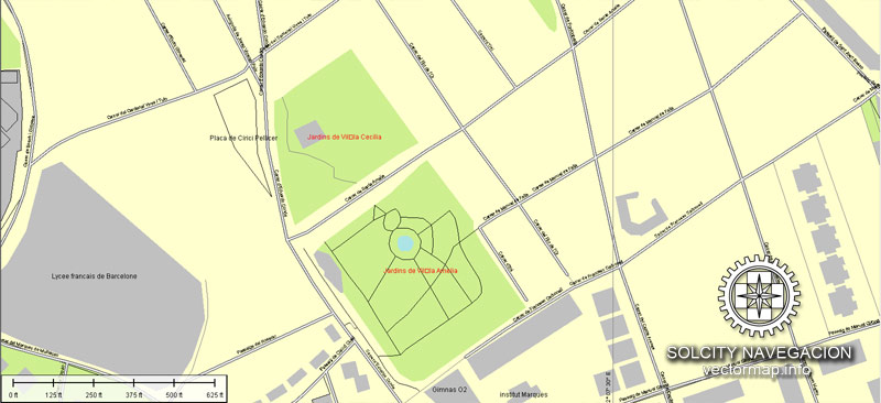
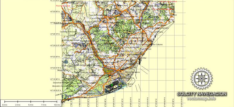
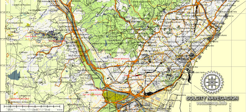
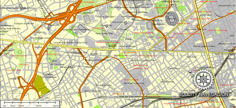
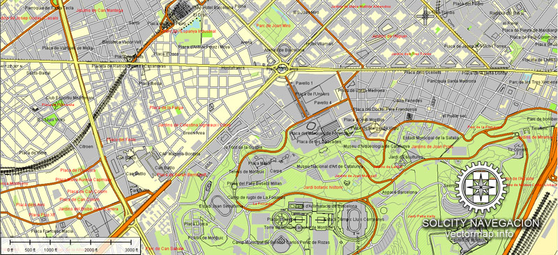
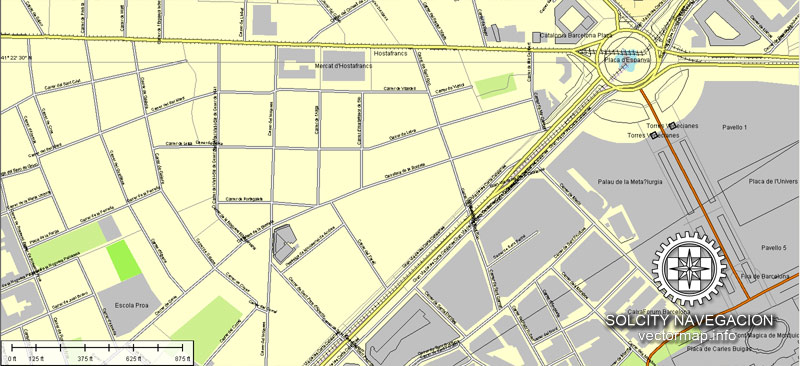
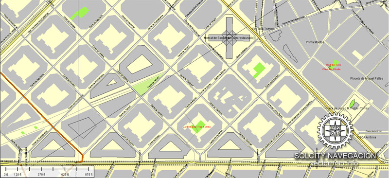
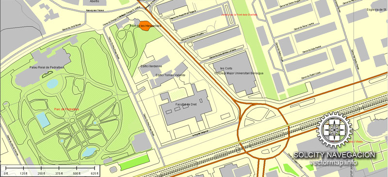
Our AI vector map of Barcelona includes maps of the nearest areas (see the preview):
Sant Adria de Besos, Badalona, El Masnou, Mollet del Valles, Vilassar de Mar, Mataro, Rubi, Cerdanyola, Martorell, Valldoreix, Molins de Rei, Cornella de Llobregat, Vallirana, Terrassa, Sant Andreu, Sarria Sant Gervasi, Sant Marti, Sants Montjuic, Horta Guinardo, Sant Genis Dels Agudells, El Carmel, El Guinardo, Gracia, Camp Nou, Esplugues de Llobregat, L`Hospitalet de Llobregat, Sants.
Purchasing and downloading of Adobe Illustrator Barcelona vectorial map
We accept PayPal and Credit Card payment.
VectorMap. Providing high quality vector maps at the lowest price of the market. Enjoy!
Small guide: How to work with the vector map?
You can: Mass select objects by type and color – for example, the objects type “building” (they are usually dark gray) – and remove them from the map, if you do not need them in your print or design project. You can also easily change the thickness of lines (streets), just bulk selection the road by the line color.
The streets are separated by type, for example, type “residential road” are usually white with a gray stroke. Highway usually orange with a brown or dark gray stroke.
All objects are divided by types: different types of roads and streets, polygons of buildings, landfills, urban areas, parks and more other.
It is easy to change the font of inscriptions, all or each individually. Also, just can be make and any other manipulation of objects on the vector map in Adobe illustrator format.
Important: All the proportions on the map are true, that is, the relative sizes of the objects are true, because Map is based on an accurate GPS projection, and It transated into the (usual for all) the Mercator projection.
You can easily change the color, stroke and fill of any object on the map, zoom without loss of quality Image Verification.
See also:
Printable map of Malaga in vector


 Author: Kirill Shrayber, Ph.D. FRGS

 Street Map editable Adobe Illustrator in layers")