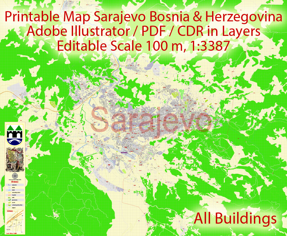
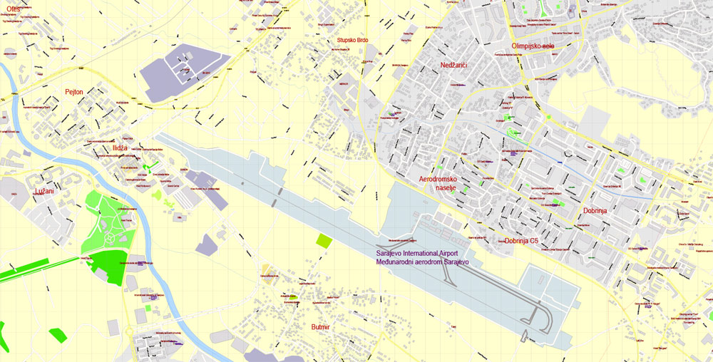
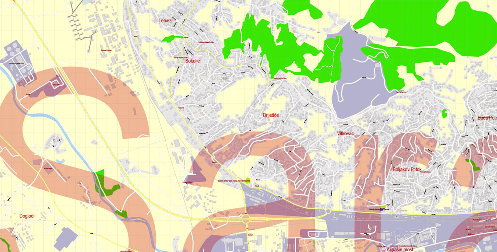
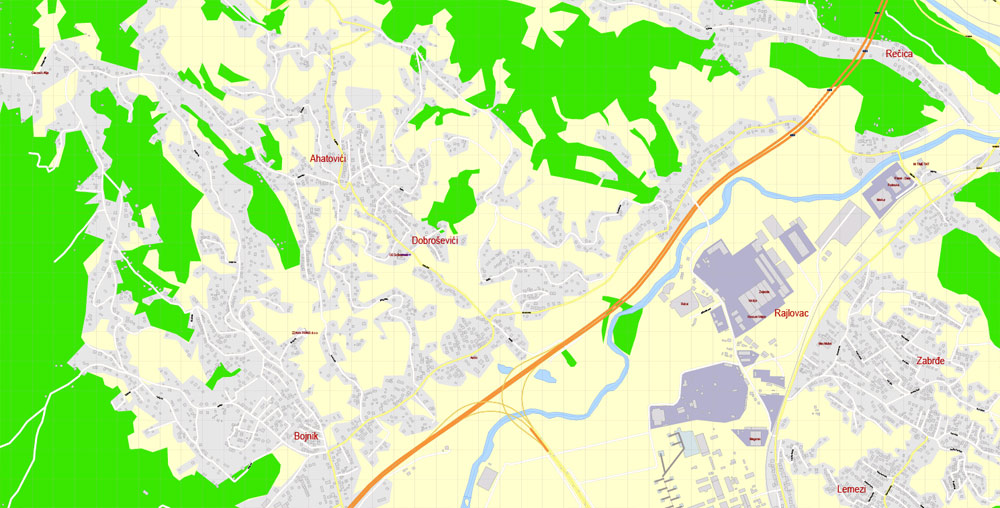
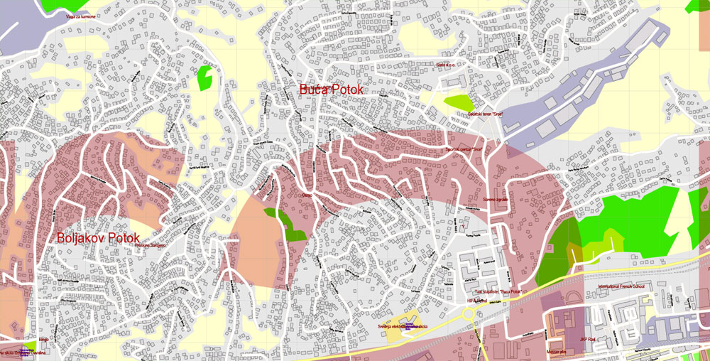
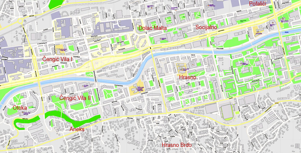
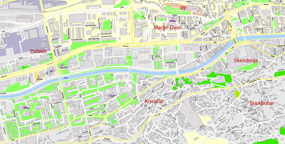
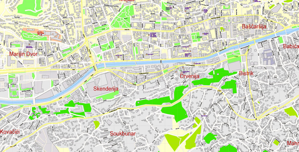
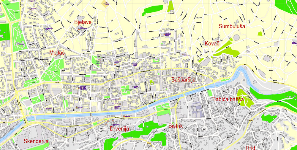
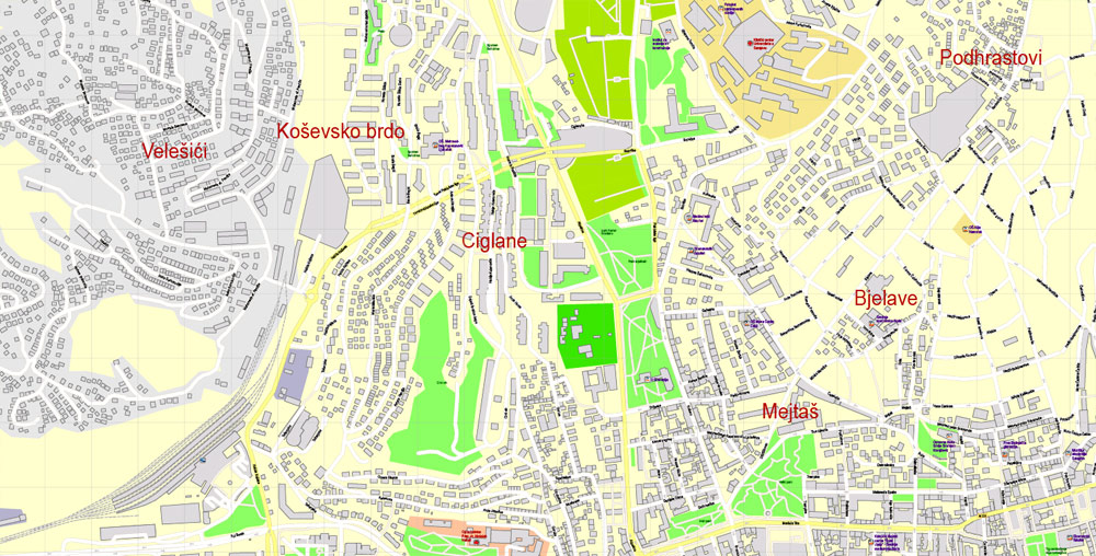
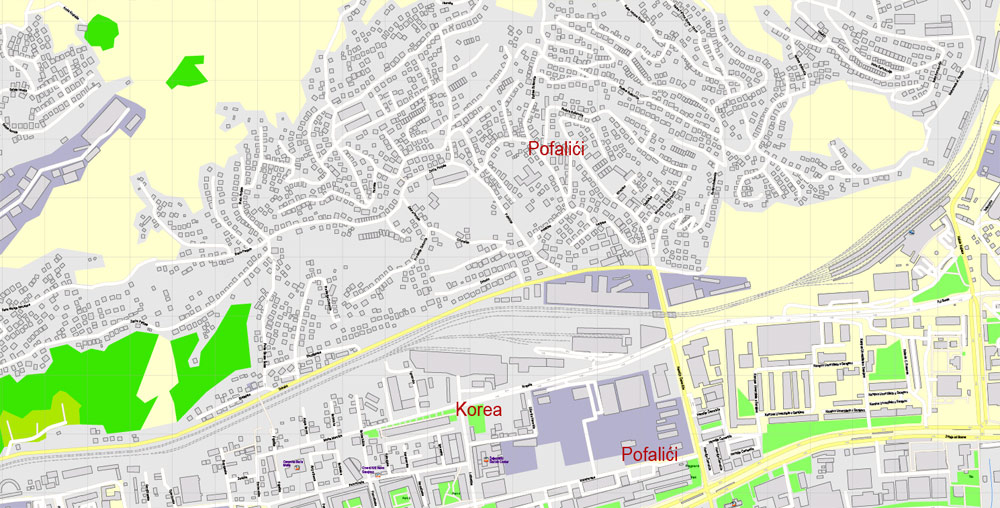
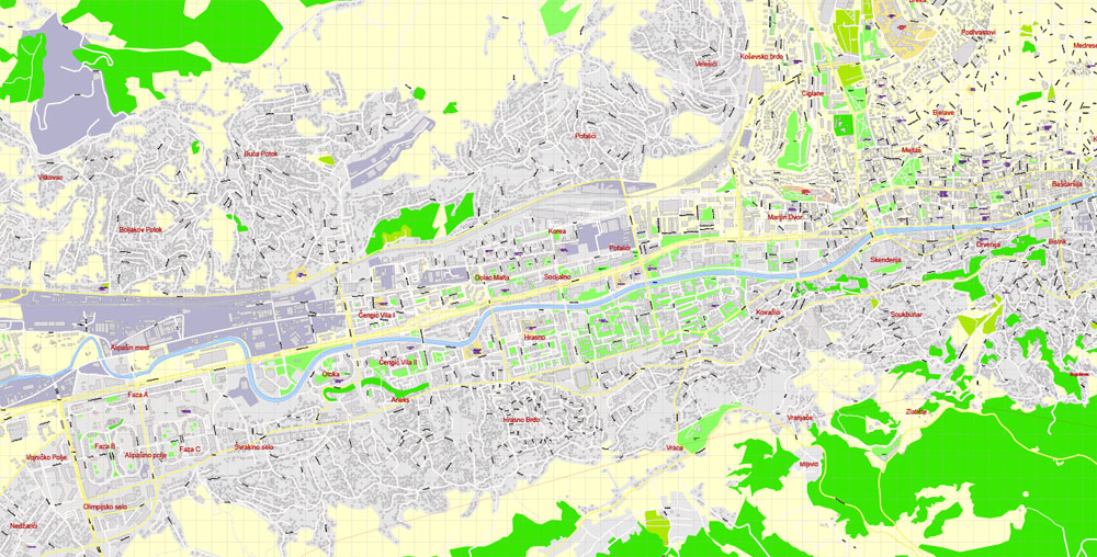
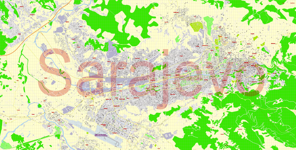
Printable Vector Map Sarajevo all buildings Bosnia and Herzegovina, exact detailed City Plan, 100 meters scale map 1:3387, editable Layered Adobe Illustrator, 14 Mb ZIP.
All streets named, main objects, all buildings. Map for publishing, design, printing, publications, arts, projects, presentations, for architects, designers and builders, business, logistics. The most exact and detailed map of the city.
Layers: legend, grids, labels_roads, names_places, buildings, names_buildings, names_streets, names_objects, objects, arrows_streets, streets_roads, color_fills, etc.
Text format all names
DWG, DXF, CDR, ESRI Shapes, and other formats – by request, same price, please contact.
Sarajevo, Bosnia and Herzegovina.
This vector map of Sarajevo city is used as a basis for design, editing, and further printing.
This is the most detailed, exact map of Sarajevo city for high-quality printing and polygraphy. You can always clarify the map development date by contacting us.
For your convenience, all objects on Sarajevo vector city map are divided into layers. And the editing is very easy – colors, lines, etc.
You can easily add any objects needed (e.g. shops, salons, sale points, gas station or attraction) on any layer of Sarajevo vector map.
One of the advantages of Sarajevo city vector maps of our production is the relevance of cartographic data, we constantly update all our products.
Sarajevo is the capital and largest city of Bosnia and Herzegovina, with a population of 275,524 in its administrative limits. The Sarajevo metropolitan area, including Sarajevo Canton, East Sarajevo and nearby municipalities, is home to 555,210 inhabitants.a Nestled within the greater Sarajevo valley of Bosnia, it is surrounded by the Dinaric Alps and situated along the Miljacka River in the heart of the Balkans.
This vector map of Sarajevo city is used by:
designers, layout designers, printers, advertisers and architects. Our product – vector maps – is designed for further editing and printing in large formats – from @Wall format (a few meters) to A-0 and A-1, A-2, A-3.
The Sarajevo city map in vector format is used for design, urban planning, presentations and media visualizations.
The advertising and presentation map of Sarajevo city (usually the final designer marks the routes, and puts the client’s objects (shops, saloons, gas stations etc.)
The undoubted advantage is that people will NEVER throw out this advertising product – the map. In fact, as an advertising medium, a city map is the most “long-playing” of the well-known polygraphic advertising media, with the longest lifespan, and the maximum number of interactions with the customer.
For travelers, maps are sold at the airports and gas stations around the world. Often the source is our vector maps.
Take a look, who purchases our vector maps of Sarajevo city in “Our Clients and Friends” page – these are large and small companies, from super-brands like Volvo and Starbucks, to small design studios and printing houses.
Sarajevo is the political, social and cultural center of Bosnia and Herzegovina, a prominent center of culture in the Balkans, with its region-wide influence in entertainment, media, fashion, and the arts.
It’s very easy to work with vector maps of Sarajevo city, even for a not very experienced designer who can turn on and off the map layers, add new objects, change the colors of fill and lines according to customer requirements.
The undoubted advantage of Sarajevo city vector maps in printing is an excellent and detailed visualization, when customer can expand a large paper map and instantly define his location, find a landmark, an object or address on map, unlike using the popular electronic formats of Google and Yandex maps for example.
Printable vector maps of Sarajevo city are much more convenient and efficient than any electronic maps on your smartphone, because ALL DETAILS are displayed in the entire space of Sarajevo city map.
Useful tips on working with vector maps of cities and countries in Adobe Illustrator.
«V» – launches the Selection tool (cursor, black arrow), which makes active any vector line.
«А» – launches the Direct Selection tool (white cursor), allows you to select curve elements and drag them to the desired place.
«R» – activates the Rotate tool, which helps you rotating selected objects around the center point by 360 degrees.
«E» – gives you the opportunity to use the Eraser tool and erase unnecessary parts.
«X» – switches between Fill and Stroke in the Tools section. Try to get used to this hot key and
you will quickly understand that you can’t live and work without it.
Guides are not limited to vertical and horizontal in Adobe Illustrator. You can also create a diagonal guide for example. Moreover, you can turn any contours into guides. Select the outline and go to View > Guides > Make Guides (Create Guides), or simply press Cmd/Ctrl + 5. You can also turn the guides back into an editable object. Go to menu, View > Guides > Unlock Guides (Release Guides), select the guide you want to edit and select View > Guides > Release Guides (Reset Guides), or just press Cmd/Ctrl + Option / Alt + 5).
Due to its long and rich history of religious and cultural diversity, Sarajevo is sometimes called the “Jerusalem of Europe” or “Jerusalem of the Balkans”. It is one of only a few major European cities which have a mosque, Catholic church, Orthodox church and synagogue in the same neighborhood. A regional center in education, the city is home to the Balkans first institution of tertiary education in the form of an Islamic polytechnic called the Saraybosna Osmanlı Medrese, today part of the University of Sarajevo.
You will probably want to change the color scheme used on our Sarajevo vector city map.
To quickly and effectively play with colors.
Of course, you can do it manually, all objects in our Sarajevo city vector map are divided according to types and layers, and you can easily change the color gamma of vector objects in groups and layers.
But there is more effective way of working with the whole VECTOR MAP of Sarajevo city and all layers:
The overview dialog «Edit colors»/«Repaint Graphic Object» (this dialog box name can change depending on the context):
If you have selected a part or a layer of Sarajevo city vector map and open the dialog box by clicking the icon in the Control panel, on the Samples palette or the Color Catalog, or if you choose Edit > Edit Colors> Repaint Graphic Object, then the «Repaint Graphic Object» dialog box appears, and you get access to «Assign» and «Edit» tabs.
Although settlement in the area stretches back to prehistoric times, the modern city arose as an Ottoman stronghold in the 15th century. Sarajevo has attracted international attention several times throughout its history. In 1885, Sarajevo was the first city in Europe and the second city in the world to have a full-time electric tram network running through the city, following San Francisco. In 1914, it was the site of the assassination of Archduke Franz Ferdinand of Austria by local Young Bosnia activist Gavrilo Princip that sparked World War I, which also ended Austro-Hungarian rule in Bosnia and resulted in the creation of the Kingdom of Yugoslavia.
If a picture or a map fragment is not selected, and you open the dialog box by clicking the icon in the Control panel, on the Samples palette or in the Color Catalog, the «Edit Colors» dialog box appears and you can only access the «Edit» tab.
Regardless of the name at the top of the dialog box, the right-hand side always displays the color group of the current document, as well as two default color groups: Print Color and Grayscale. These color groups can be selected and used any time.
Create and edit color groups of Sarajevo city vector map, and also assign colors using the «Edit Colors»/ а «Repaint Graphic Object» dialog box.
A. Creating and editing of a color group on the «Edit» tab
B. Assigning colors on the «Assign» tab
C. Select a group of colors from the «Color groups» list
The option «Repaint a graphic object» in the lower part of the dialog box allows you to preview the colors on a selected layer of Vector map, or a group of elements, and specify whether its colors will be redefined when the dialog box is closed.
Later, after World War II, the establishment of the Socialist Republic of Bosnia and Herzegovina within the Second Yugoslavia led to a massive expansion of Sarajevo, the constituent republic’s capital, which culminated with the hosting of the 1984 Winter Olympics marking a prosperous era for the city. However, after the start of the Yugoslav Wars, for 1,425 days, from April 1992 to February 1996, the city suffered the longest siege of a capital city in the history of modern warfare, during the Bosnian War and the breakup of Yugoslavia.
The main areas of the dialog box are:
«Edit»
The «Edit» tab is designed to create a new or edit the existing color groups.
The harmony rules Menu and the Color Wheel are used to conduct experiments with color harmonies. The color wheel shows how colors are related in color harmony, and the color bars allow you to view and manipulate an individual color values. In addition, you can adjust the brightness, add and remove colors, save color groups and view colors on the selected Vector Map of Sarajevo city or a separated layers.
«Assign»
The «Assign» tab is used to view and control on how the original colors are replaced with colors from the color group like your corporate colors in the Vector Map of Sarajevo city.
The assign color ability is provided only if the entire map, layer or fragment is selected in the document. You can specify which of new colors replace the current colors, whether the spot colors should be preserved and how colors are replaced (for example, you can replace colors completely or changing the color tone while maintaining the brightness). The «Assign» tab allows you to redefine colors in the Vector Map of Sarajevo city, or in separate layers and fragments using the current color group or reducing the number of colors in the current Vector Map.
Sarajevo has been undergoing post-war reconstruction, and is the fastest growing city in Bosnia and Herzegovina. The travel guide series Lonely Planet has named Sarajevo as the 43rd best city in the world, and in December 2009 listed Sarajevo as one of the top ten cities to visit in 2010. In 2011, Sarajevo was nominated to be the European Capital of Culture in 2014 and will be hosting the European Youth Olympic Festival in 2019.
Color groups
Is a list of all saved color groups for current document (the same groups appear in the «Samples» palette). You can edit and delete the existing color groups, as well as creating a new ones using the list of “Color Groups” in the dialog box. All changes appear in the «Samples» palette.
The highlighted color group shows, which color group is currently edited.
Any color group can be selected and edited, or used to redefine the colors in the selected vector map of Sarajevo city, its fragments or elements.
Saving a color group adds this group to the specified list.
Opening the «Edit Colors»/«Repaint Graphic Object» dialog box.
Open the «Edit Colors»/«Repaint Graphic Object» dialog box using one of the following methods:
«Edit»> «Edit Colors»> «Repaint Graphic object» or «Repaint With Style».
Use these commands if you need to edit the colors in the selected vector map of Sarajevo city.
Geography
Sarajevo is near the geometric center of the triangular-shaped Bosnia-Herzegovina and within the historical region of Bosnia proper. It is situated 518 meters (1,699 ft) above sea level and lies in the Sarajevo valley, in the middle of the Dinaric Alps. The valley itself once formed a vast expanse of greenery, but gave way to urban expansion and development in the post-World War II era. The city is surrounded by heavily forested hills and five major mountains.
«Repaint Graphic object» button on the «Control» panel.
Use this button if you need to adjust colors of Sarajevo city vector map using the а «Repaint graphic object» dialog box.
The specified button is available if the selected vector map or its fragment contains two or more colors.
Note. This color editing method is convenient for global color adjustment in a vector map, if global colors were not used when creating a City Map of Sarajevo.
The «Edit colors» button or «Edit or apply colors» on the «Color Catalog» palette
Click this button if you need to edit colors on the «Color Catalog» palette or edit and then apply them to the selected Vector Map of Sarajevo city or its fragment.
The «Edit color group» button or «Edit or apply color group» on the «Samples» palette.
Click this button if you need to edit the colors in the specific color group or edit and apply them to the selected Vector Map of Sarajevo city or a group of its elements, for example, the whole layer “Streets and lines”. You can also double-click the color group in the Samples panel to open the dialog box.
If the map file is too large and your computer freezes or even can’t open it quickly:
1. Try to reduce the color resolution of the video card (display) to 256 colors while working with a large map.
2. Using Windows Task Manager, select all the application you don’t need, while working with map, just turn them off.
3. Launch Adobe Illustrator. (DO NOT OPEN the vector map file)
4. Start the Windows Task Manager using administrator rights > Find the “Illustrator” process > set the «real time» priority,
5. Open the file. When you see the LEGACY FONT popup window – click “OK” (do not update). You can restore the TEXT later.
6. Can also be useful: When file is opened – Edit > Settings > Basic Settings > disable smoothing. /// It looks scary, but works quickly)))
We recommend saving the file in Adobe Illustrator 10 version. It’s much more stable when working with VERY BIG size files.
The highest of the surrounding peaks is Treskavica at 2,088 meters (6,850 ft), then Bjelašnica mountain at 2,067 meters (6,781 ft), Jahorina at 1,913 meters (6,276 ft), Trebević at 1,627 meters (5,338 ft), with 1,502 meters (4,928 ft) Igman being the shortest. The last four are also known as the Olympic Mountains of Sarajevo (see also 1984 Winter Olympics). The city itself has its fair share of hilly terrain, as evidenced by the many steeply inclined streets and residences seemingly perched on the hillsides.
The Miljacka river is one of the city’s chief geographic features. It flows through the city from east through the center of Sarajevo to west part of city where eventually meets up with the Bosna river. Miljacka river is “The Sarajevo River”, with its source (Vrelo Miljacke) 2 kilometres (1.2 miles) south of the town of Pale at the foothills of Mount Jahorina, several kilometers to the east of Sarajevo center. The Bosna’s source, Vrelo Bosne near Ilidža (west Sarajevo), is another notable natural landmark and a popular destination for Sarajevans and other tourists. Several smaller rivers and streams such as Koševski Potok also run through the city and its vicinity.
Cityscape
Sarajevo is close to the center of the triangular shape of Bosnia and Herzegovina in southeastern Europe. Sarajevo city proper consists of four municipalities (or “in Bosnian and Croatian: općina, in Serbian: opština”): Centar (Center), Novi Grad (New City), Novo Sarajevo (New Sarajevo), and Stari Grad (Old City), while Metropolitan area of Sarajevo (Greater Sarajevo area) includes these and the neighbouring municipalities of Ilidža, Hadžići, Vogošća and Ilijaš.
The Metropolitan area was reduced in the 1990s after the war and the Dayton-imposed administrative division of the country, with several municipalities partitioned along the border of the newly recognised Federation of Bosnia and Herzegovina (FBiH) and Republica Srpska (RS), creating several new municipalities which together form the city of Istočno Sarajevo in the Republica Srpska: Istočna Ilidza, Istočno Novo Sarajevo, Istočni Stari Grad, Lukavica, Pale (RS-section), and Trnovo (RS-section), along with the municipality of Sokolac (which was not traditionally part of the Sarajevo area and was not partitioned)
The city has an urban area of 1,041.5 square kilometres (402.1 sq mi). Veliki Park (Great park) is the largest green area in the center of Sarajevo. It’s nestled between Titova, Koševo, Džidžikovac, Tina Ujevića and Trampina Streets and in the lower part there is a monument dedicated to the Children of Sarajevo.
Sarajevo
Capital of Bosnia and Herzegovina
Sarajevo, capital of Bosnia and Herzegovina, is a compact city on the Miljacka River, surrounded by the Dinaric Alps. Its center has museums commemorating local history, including Sarajevo 1878–1918, which covers the 1914 assassination of Archduke Franz Ferdinand, an event that sparked World War I. Landmarks of the old quarter, Baščaršija, include the Ottoman-era Gazi Husrev-bey Mosque.
Area
• City 141.5 km2 (54.6 sq mi)
• Urban 489 km2 (189 sq mi)
• Metro 3,350 km2 (1,290 sq mi)
Elevation 550 m (1,800 ft)
Population
• City 275,524
• Density 1,900/km2 (5,000/sq mi)
• Urban 395,133
• Urban density 810/km2 (2,100/sq mi)
• Metro 555,210
• Metro density 170/km2 (430/sq mi)
Free vector maps:

Free download printable map Europe vector Adobe Illustrator >>>
Free download printable PDF map Europe vector Adobe PDF >>>

 Author: Kirill Shrayber, Ph.D. FRGS
