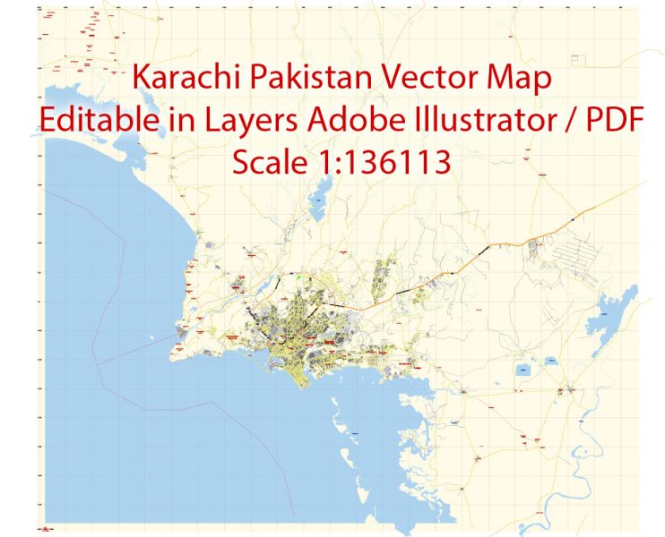
Printable PDF Vector Map of Karachi Pakistan EN low detailed City Plan scale 1:136113 full editable Adobe PDF Street Map in layers for small print size, scalable, editable text format all names, 7 mb ZIP
English streets names, Main Objects, Buildings. Map for design, printing, arts, projects, presentations, for architects, designers and builders, business, logistics.
Layers: color_fills, streets_roads, labels_roads, names_objects, names_streets, names_places, grids, legend.
The most exact low detailed map of the city in scale.
For Editing and High Quality Printing
DWG, DXF and other formats – on request, same price, please, contact
Karachi
City in Pakistan
Karachi is the capital of the Pakistani province of Sindh. It is the most populous city in Pakistan, and sixth-most-populous city proper in the world. Ranked as a beta world city, the city is Pakistan’s premier industrial and financial centre.
Karachi is the capital of the Pakistani province of Sindh. It is the most populous city in Pakistan, and sixth-most-populous city proper in the world. Ranked as a beta world city, the city is Pakistan’s premier industrial and financial centre. Karachi is also Pakistan’s most cosmopolitan city. Situated on the Arabian Sea, Karachi serves as a transport hub, and is home to Pakistan’s two largest seaports, the Port of Karachi and Port Bin Qasim, as well as the busiest airport in Pakistan.
Area
• Total 3,780 km2 (1,460 sq mi)
Elevation 8 m (26 ft)
Population
• Total 14,910,352 (provisional)
• Rank 1st in Pakistan
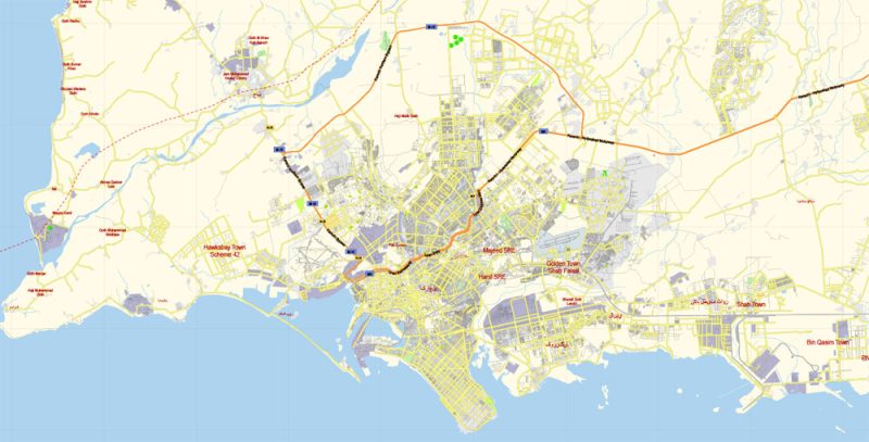
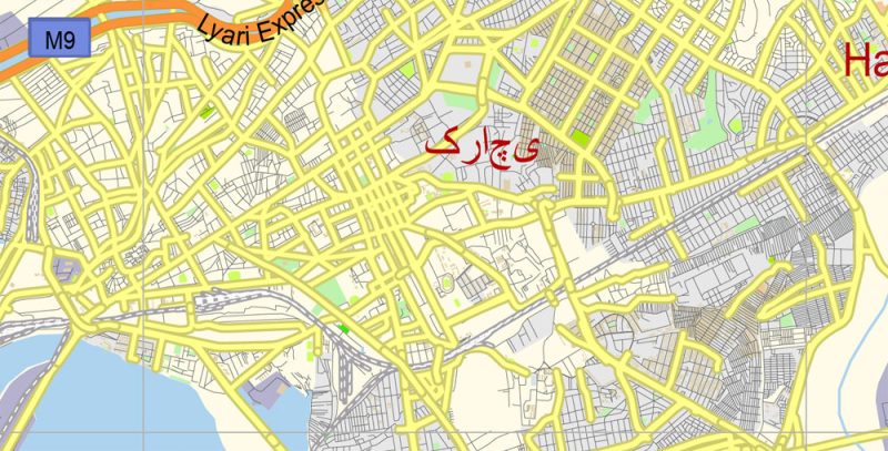
Karachi PDF Map Vector Pakistan low detailed City Plan editable overview
You can easily add any objects needed (e.g. shops, salons, sale points, gas station or attraction) on any layer of Karachi vector map.
Though the Karachi region has been inhabited for millennia, the city was founded as the fortified village of Kolachi in 1729.
The Karachi city map in vector format is used for design, urban planning, presentations and media visualizations.
The settlement drastically increased in importance with the arrival of British East India Company in the mid 19th century, who not only embarked on major works to transform the city into a major seaport, but also connected it with their extensive railway network.
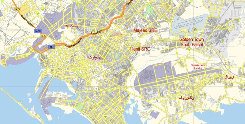
Karachi PDF Map Vector Pakistan low detailed City Plan editable preview 1
For travelers, maps are sold at the airports and gas stations around the world. Often the source is our vector maps.
By the time of the Partition of British India, the city was the largest in Sindh with an estimated population of 400,000. Following the independence of Pakistan, the city’s population increased dramatically with the arrival of hundreds of thousands of Muslim refugees from India. The city experienced rapid economic growth following independence, attracting migrants from throughout Pakistan and South Asia.
The advertising and presentation map of Karachi city (usually the final designer marks the routes, and puts the client’s objects (shops, saloons, gas stations etc.)
The undoubted advantage is that people will NEVER throw out this advertising product – the map.
Take a look, who purchases our vector maps of Karachi city in “Our Clients and Friends” page – these are large and small companies, from super-brands like Volvo and Starbucks, to small design studios and printing houses.
In fact, as an advertising medium, a city map is the most “long-playing” of the well-known polygraphic advertising media, with the longest lifespan, and the maximum number of interactions with the customer.
Karachi is one of Pakistan’s most secular and socially liberal cities. It is also the most linguistically, ethnically, and religiously diverse city in Pakistan. It has been termed as a the country’s fashion capital and home to Pakistan’s first Fashion week the now regular Karachi Fashion week in 2009. With a population of 14.9 million recorded in the 2017 Census of Pakistan, Karachi is the world’s 6th most populous metropolitan area. Karachi is one of the world’s fastest growing cities, and has communities representing almost every ethnic group in Pakistan.
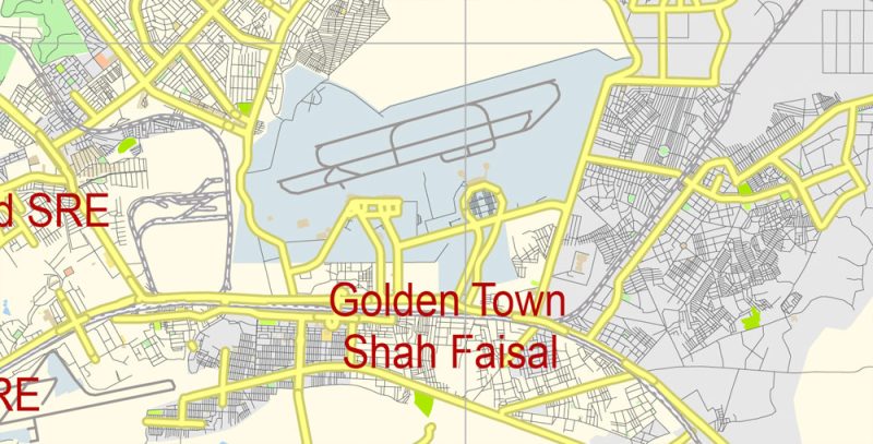
Karachi PDF Map Vector Pakistan low detailed City Plan editable preview 2
It’s very easy to work with vector maps of Karachi city, even for a not very experienced designer who can turn on and off the map layers, add new objects, change the colors of fill and lines according to customer requirements.
Karachi is home to over 2 million Bangladeshi immigrants, 1 million Afghan refugees, and up to 400,000 Rohingyas from Myanmar.
Karachi is now Pakistan’s premier industrial and financial centre. The city has a formal economy estimated to be worth $113 billion as of 2014 which is the largest in Pakistan. Karachi collects over a third of Pakistan’s tax revenue, and generates approximately 20% of Pakistan’s GDP. Approximately 30% of Pakistani industrial output is from Karachi, while Karachi’s ports handle approximately 95% of Pakistan’s foreign trade.
Guides are not limited to vertical and horizontal in Adobe Illustrator. You can also create a diagonal guide for example. Moreover, you can turn any contours into guides. Select the outline and go to View > Guides > Make Guides (Create Guides), or simply press Cmd/Ctrl + 5. You can also turn the guides back into an editable object. Go to menu, View > Guides > Unlock Guides (Release Guides), select the guide you want to edit and select View > Guides > Release Guides (Reset Guides), or just press Cmd/Ctrl + Option / Alt + 5).
Approximately 90% of the multinational corporations operating in Pakistan are headquartered in Karachi. The global FDI intelligence 2017/2018 report of the Financial Times ranks Karachi amongst the top 10 asia pacific cities of the future for FDI strategy.
Karachi PDF Map Vector Pakistan low detailed City Plan editable preview 3
Useful tips on working with vector maps of cities and countries in Adobe Illustrator.
«V» – launches the Selection tool (cursor, black arrow), which makes active any vector line.
«А» – launches the Direct Selection tool (white cursor), allows you to select curve elements and drag them to the desired place.
«R» – activates the Rotate tool, which helps you rotating selected objects around the center point by 360 degrees.
«E» – gives you the opportunity to use the Eraser tool and erase unnecessary parts.
«X» – switches between Fill and Stroke in the Tools section. Try to get used to this hot key and
you will quickly understand that you can’t live and work without it.
Use these commands if you need to edit the colors in the selected vector map of Karachi city.
«Repaint Graphic object» button on the «Control» panel.
Use this button if you need to adjust colors of Karachi city vector map using the а «Repaint graphic object» dialog box.
Karachi is located on the coastline of Sindh province in southern Pakistan, along a natural harbour on the Arabian Sea. Karachi is built on a coastal plains with scattered rocky outcroppings, hills and coastal marshlands.
The undoubted advantage of Karachi city vector maps in printing is an excellent and detailed visualization, when customer can expand a large paper map and instantly define his location, find a landmark, an object or address on map, unlike using the popular electronic formats of Google and Yandex maps for example.
Coastal mangrove forests grow in the brackish waters around the Karachi Harbour, and farther southeast towards the expansive Indus River Delta. West of Karachi city is the Cape Monze, locally known as Ras Muari, which is an area characterised by sea cliffs, rocky sandstone promontories and undeveloped beaches.
Karachi PDF Map Vector Pakistan low detailed City Plan editable preview 4
Within the city of Karachi are two small ranges: the Khasa Hills and Mulri Hills, which lie in the northwest and act as a barrier between North Nazimabad Town and Orangi Town. Karachi’s hills are barren and are part of the larger Kirthar Range, and have a maximum elevation of 528 metres (1,732 feet).
Between the hills are wide coastal plains interspersed with dry river beds and water channels. Karachi has developed around the Malir River and Lyari Rivers, with the Lyari shore being the site of the settlement for Kolachi. To the west of Karachi lies the Indus River flood plain.
Printable vector maps of Karachi city are much more convenient and efficient than any electronic maps on your smartphone, because ALL DETAILS are displayed in the entire space of Karachi city map.
Cityscape
The city first developed around the Karachi Harbour, and owes much of its growth to its role as a seaport at the end of the 18th century, contrasted with Pakistan’s millennia-old cities such as Lahore, Multan, and Peshawar. Karachi’s Mithadar neighbourhood represents the extent of Kolachi prior to British rule.
British Karachi was divided between the “New Town” and the “Old Town,” with British investments focused primarily in the New Town. Regardless of the name at the top of the dialog box, the right-hand side always displays the color group of the current document, as well as two default color groups: Print Color and Grayscale. These color groups can be selected and used any time.
One of the advantages of Karachi city vector maps of our production is the relevance of cartographic data, we constantly update all our products.
You will probably want to change the color scheme used on our Karachi vector city map.
To quickly and effectively play with colors.
Of course, you can do it manually, all objects in our Karachi city vector map are divided according to types and layers, and you can easily change the color gamma of vector objects in groups and layers.
The Old Town was a largely unplanned neighbourhood which housed most of the city’s indigenous residents, and had no access to sewerage systems, electricity, and water. The New Town was subdivided into residential, commercial, and military areas.
This is the most detailed, exact map of Karachi city for high-quality printing and polygraphy. You can always clarify the map development date by contacting us.
Given the strategic value of the city, the British developed the Karachi Cantonment as a military garrison in the New Town to aid the British war effort in the First Anglo-Afghan War. But there is more effective way of working with the whole VECTOR MAP of Karachi city and all layers:
The overview dialog «Edit colors»/«Repaint Graphic Object» (this dialog box name can change depending on the context):
If you have selected a part or a layer of Karachi city vector map and open the dialog box by clicking the icon in the Control panel, on the Samples palette or the Color Catalog, or if you choose Edit > Edit Colors> Repaint Graphic Object, then the «Repaint Graphic Object» dialog box appears, and you get access to «Assign» and «Edit» tabs.
If a picture or a map fragment is not selected, and you open the dialog box by clicking the icon in the Control panel, on the Samples palette or in the Color Catalog, the «Edit Colors» dialog box appears and you can only access the «Edit» tab.
This vector map of Karachi city is used by:
designers, layout designers, printers, advertisers and architects. Our product – vector maps – is designed for further editing and printing in large formats – from @Wall format (a few meters) to A-0 and A-1, A-2, A-3.
The city’s development was largely confined to the area north of the Chinna Creek prior to independence, although the seaside area of Clifton was also developed as a posh locale under the British, and its large bungalows and estates remain some of the city’s most desirable properties. The aforementioned historic areas form the oldest portions of Karachi, and contain its most important monuments and government buildings, with the I. I. Chundrigar Road being home to most of Pakistan’s banks, including the Habib Bank Plaza which was Pakistan’s tallest building from 1963 until the early 2000s. The specified button is available if the selected vector map or its fragment contains two or more colors.
Note. This color editing method is convenient for global color adjustment in a vector map, if global colors were not used when creating a City Map of Karachi.
The «Edit colors» button or «Edit or apply colors» on the «Color Catalog» palette
Click this button if you need to edit colors on the «Color Catalog» palette or edit and then apply them to the selected Vector Map of Karachi city or its fragment.
The «Edit color group» button or «Edit or apply color group» on the «Samples» palette.
For your convenience, all objects on Karachi vector city map are divided into layers. And the editing is very easy – colors, lines, etc.
Much of Karachi’s skyline is decentralized, with some growth in traditionally suburban areas.
Situated on a coastal plain northwest of Karachi’s historic core lies the sprawling district of Orangi Town. North of the historic core is the largely middle-class district of Nazimabad, and upper-middle class North Nazimabad, which were developed in the 1950s. To the east of the historic core is the area known as Defence – an expansive upscale suburb developed and administered by the Pakistan Army. Karachi’s coastal plains along the Arabian Sea south of Clifton were also developed much later as part of the greater Defence Housing Authority project.
District municipal corporations
In 2011, city district government of Karachi was reverted its original constituent units known as District Municipal Corporations (DMC). The five original DMCs are: Karachi East, Karachi West, Karachi Central, Karachi South and Malir. In November 2013, a sixth DMC, “Korangi” was carved out from District East.
The current city administrator is Muhammad Hussain Syed and Municipal Commissioner of Karachi is Matanat Ali Khan. The position of Commissioner of Karachi was created and Shoaib Ahmad Siddiqui was appointed as the Commissioner of Karachi. There are six military cantonments, which are administered by the Pakistani Army, and are some of Karachi’s most upscale neighbourhoods.
Create and edit color groups of Karachi city vector map, and also assign colors using the «Edit Colors»/ а «Repaint Graphic Object» dialog box.
A. Creating and editing of a color group on the «Edit» tab
B. Assigning colors on the «Assign» tab
C. Select a group of colors from the «Color groups» list
The option «Repaint a graphic object» in the lower part of the dialog box allows you to preview the colors on a selected layer of Vector map, or a group of elements, and specify whether its colors will be redefined when the dialog box is closed.
The main areas of the dialog box are:
«Edit»
The «Edit» tab is designed to create a new or edit the existing color groups.
The harmony rules Menu and the Color Wheel are used to conduct experiments with color harmonies. The color wheel shows how colors are related in color harmony, and the color bars allow you to view and manipulate an individual color values. In addition, you can adjust the brightness, add and remove colors, save color groups and view colors on the selected Vector Map of Karachi city or a separated layers.
Assign
The «Assign» tab is used to view and control on how the original colors are replaced with colors from the color group like your corporate colors in the Vector Map of Karachi city.
The assign color ability is provided only if the entire map, layer or fragment is selected in the document. You can specify which of new colors replace the current colors, whether the spot colors should be preserved and how colors are replaced (for example, you can replace colors completely or changing the color tone while maintaining the brightness). The «Assign» tab allows you to redefine colors in the Vector Map of Karachi city, or in separate layers and fragments using the current color group or reducing the number of colors in the current Vector Map.
Click this button if you need to edit the colors in the specific color group or edit and apply them to the selected Vector Map of Karachi city or a group of its elements, for example, the whole layer “Streets and lines”. You can also double-click the color group in the Samples panel to open the dialog box.
If the map file is too large and your computer freezes or even can’t open it quickly:
1. Try to reduce the color resolution of the video card (display) to 256 colors while working with a large map.
2. Using Windows Task Manager, select all the application you don’t need, while working with map, just turn them off.
3. Launch Adobe Illustrator. (DO NOT OPEN the vector map file)
4. Start the Windows Task Manager using administrator rights > Find the “Illustrator” process > set the «real time» priority,
5. Open the file. When you see the LEGACY FONT popup window – click “OK” (do not update). You can restore the TEXT later.
6. Can also be useful: When file is opened – Edit > Settings > Basic Settings > disable smoothing. /// It looks scary, but works quickly)))
We recommend saving the file in Adobe Illustrator 10 version. It’s much more stable when working with VERY BIG size files.
Free vector map World, Adobe Illustrator, download now maps vector clipart
Map for design, projects, presentation free to use as you like.
See also: TERMS & CONDITIONS: SOFTWARE LICENSE AGREEMENT FOR DIGITAL CARTOGRAPHIC DATA.
Need more USA Vector Maps, printable and editable?


 Author: Kirill Shrayber, Ph.D. FRGS


