Extended Description of the Vector Map
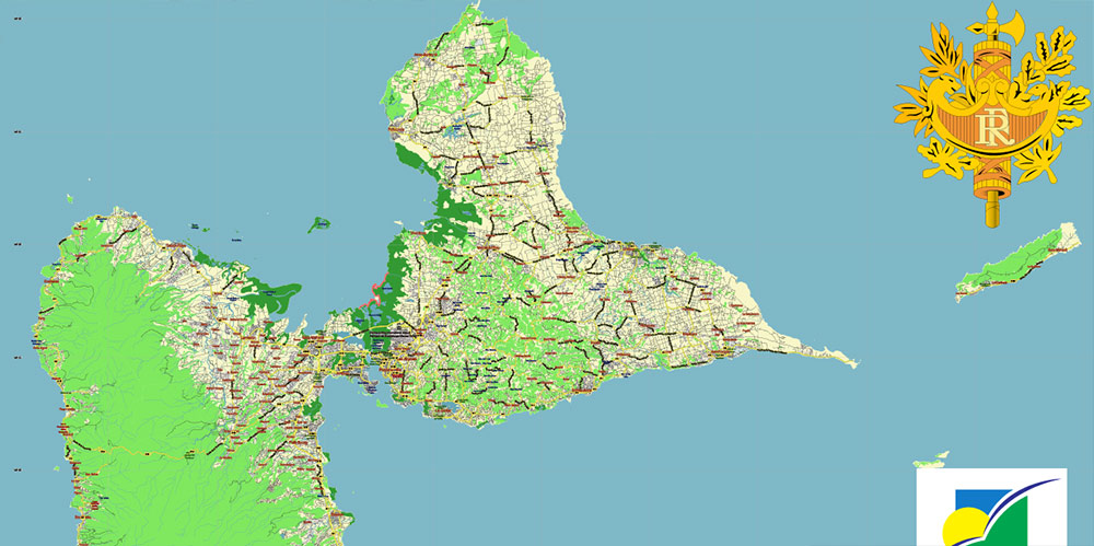
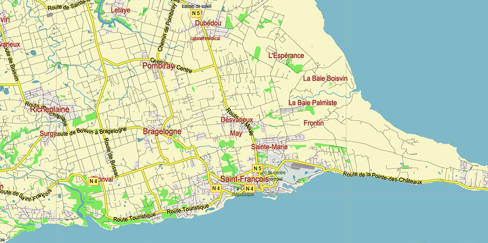
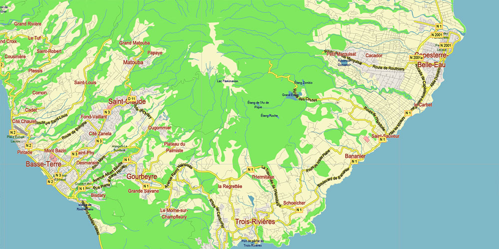
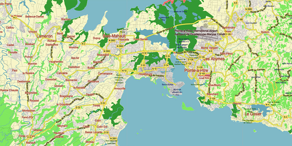
Printable PDF Vector Map of Guadeloupe France high detailed road map editable Layered Adobe PDF, scalable, editable text/curves format of names, 16 Mb ZIP.
Layered exact editable map: Map for publishing, design, printing, publications, arts, projects, presentations, for architects, designers, and builders, business, logistics. The most exact and detailed map. GPS correct Mercator Projection.
For printing any format.
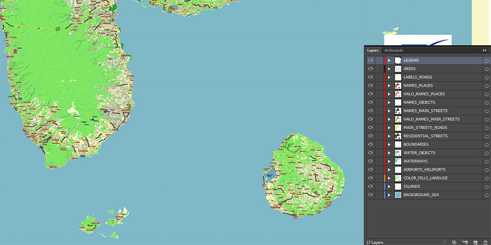
Please note: in the preview, ALL LAYERS are enabled and visible. Of course, you can easily turn off the layers you don’t need and the map will become much simpler.
DWG, DXF, CDR, ESRI Shapes, and other formats – by request, the same price, please contact.
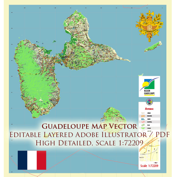
Guadeloupe France PDF Vector Map high detailed road map editable Layered Adobe PDF
Separated layers:
- Legend
- Grids
- Road labels
- Names Places + Halo
- Names Water objects (areas)
- Names main streets and roads + Halo
- Main roads and streets
- Residential streets and roads
- Country boundaries
- Waterways
- Water areas
- Landuse areas
- Islands
- Background and Sea
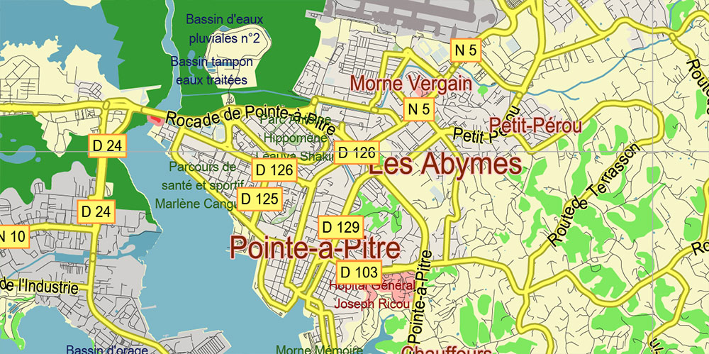
Guadeloupe France PDF Vector Map high detailed road map editable Layered Adobe PDF
AO BRIEF: GUADELOUPE ARCHIPELAGO (FRANCE)
1. OVERVIEW
-
Location: Eastern Caribbean, Leeward Islands.
-
Status: French overseas department; EU territory.
-
Composition: Two main islands (Basse-Terre and Grande-Terre) + satellite islands (Marie-Galante, La Désirade, Les Saintes cluster).
-
Terrain Split: Western massifs (volcanic, steep) vs eastern plateaus (limestone, low relief).
-
Strategic Value: Deep-water approaches, weather chokepoints, large sheltered bays, complex microterrain for concealment.
2. KEY LANDMASS ELEMENTS
BASSE-TERRE (WESTERN ISLAND)
-
Type: Volcanic spine; rugged, forested, sparsely urbanized.
-
Elevation: Dominated by La Soufrière stratovolcano (~1467 m).
-
Terrain Features:
-
Dense rainforest canopy (Parc National)
-
Sharp river valleys, waterfalls, minimal flat ground
-
Numerous ravines used as natural movement corridors
-
Operational Notes:
-
LOS (line-of-sight) limited; GPS signal degradation in valleys.
-
Thermal signatures masked by humidity and canopy.
-
East–west traversal extremely slow.
GRANDE-TERRE (EASTERN ISLAND)
-
Type: Limestone plateau; low hills, rolling fields.
-
Coastline: Fringing reefs, long beaches, eroded cliffs on Atlantic side.
-
Urban Areas:
-
Largest population concentration
-
Main logistics hubs, road grid, airfield access
-
Operational Notes:
MARIE-GALANTE
-
Shape: Circular limestone platform.
-
Terrain: Sugarcane agriculture; gentle slopes, small cliffs on east.
-
Notes:
LES SAINTES (ARCHIPELAGO)
LA DÉSIRADE
3. CLIMATE / SEASONALITY
-
Type: Tropical maritime.
-
Dry Season: December–April; stable weather, clearer skies.
-
Wet Season: June–November; heavy rains, flash floods.
-
Hurricane Risk: Significant; terrain becomes impassable post-storm.
-
Operational Impact:
-
High humidity degrades optics and electronics.
-
Rapid onset storms complicate air/sea operations.
-
Heat stress risk in interior rainforest.
4. LINES OF COMMUNICATION (LOCs)
Major Roads
-
Route Nationale 1 (RN1): Along Grande-Terre north coast.
-
Route Nationale 2 (RN2): Encircles Basse-Terre, primary movement axis.
-
RN4: Connects the two islands via the Rivière Salée bridge.
Airfields
Seaports
-
Pointe-à-Pitre: Deep-water commercial harbour, logistics center.
-
Basse-Terre Port: Smaller, governmental presence.
-
Les Saintes Bay: Natural harbor suitable for small craft.
5. DEMOGRAPHY / HUMAN TERRAIN
-
Population: ~400,000 residents.
-
Distribution:
-
Urban Nodes:
-
Languages: French (official), Antillean Creole widely spoken.
-
Posture: Civilian-heavy AO; dense traffic corridors; limited rural habitation on western island.
6. TOURISM / KEY COMPOUNDS
-
Beach clusters: Sainte-Anne, Le Gosier, Saint-François.
-
National Park: Waterfalls, volcano slopes (restricted zones).
-
Hotel zones: Mostly on Grande-Terre, especially south coast.
-
Cruise infrastructure: Pointe-à-Pitre — episodic crowd surges.
7. HAZARDS / THREATS
-
Volcanic: La Soufrière active fumarolic complex; sudden gas events possible.
-
Seismic: Located along Caribbean Plate boundary — frequent tremors.
-
Hydrological:
-
Marine: Strong Atlantic rip currents, reefs, shallow shoals.
-
Biological:
-
Human:
8. LOGISTICS / SUSTAINMENT
-
Fuel: Concentrated in Grande-Terre.
-
Supplies: Imported; ports are single points of failure.
-
Water:
-
Medical: Major hospitals in Pointe-à-Pitre and Basse-Terre.
-
Power: Coastal grid; interior has pocket outages in storms.
9. COMMAND TAKEAWAYS
-
Treat Basse-Terre as mountain jungle terrain — movement slow, concealment high.
-
Treat Grande-Terre as open limestone AO — fast mobility, but exposure.
-
Maintain weather alert posture year-round.
-
Use Les Saintes for forward picket or recon staging.
-
Use Marie-Galante for rapid deployment/landing drills (large flat LZs).
-
Control RN2–RN4 junction to secure inter-island mobility.
-
Expect civilian saturation in urban nodes; minimize kinetic footprint.
Guadeloupe France PDF Vector Map high detailed road map editable Layered Adobe PDF
Guadeloupe France PDF Vector Map high detailed road map editable Layered Adobe PDF
Guadeloupe France PDF Vector Map high detailed road map editable Layered Adobe PDF
Guadeloupe France PDF Vector Map high detailed road map editable Layered Adobe PDF
Guadeloupe France PDF Vector Map high detailed road map editable Layered Adobe PDF

 Author: Kirill Shrayber, Ph.D. FRGS