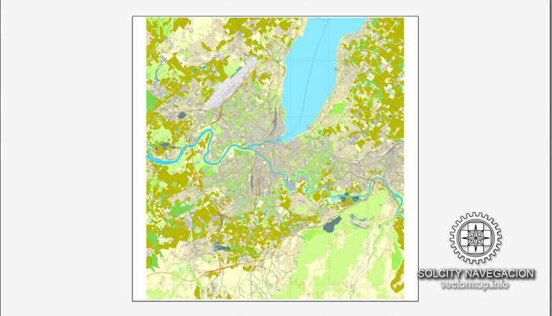
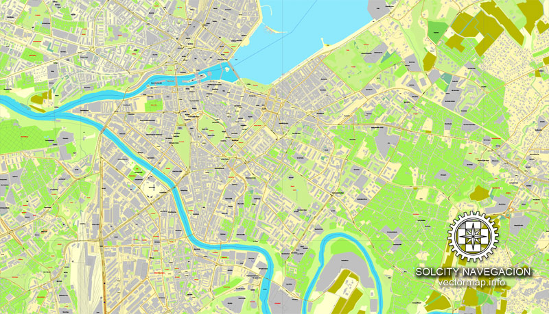
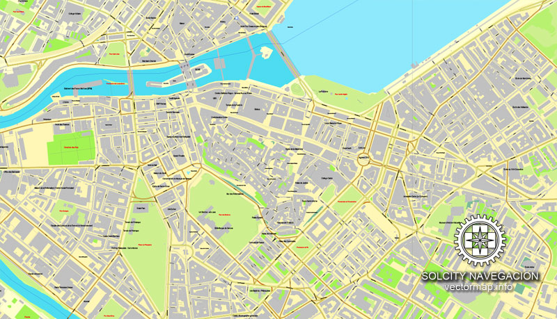
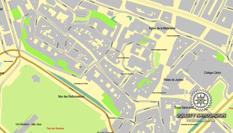
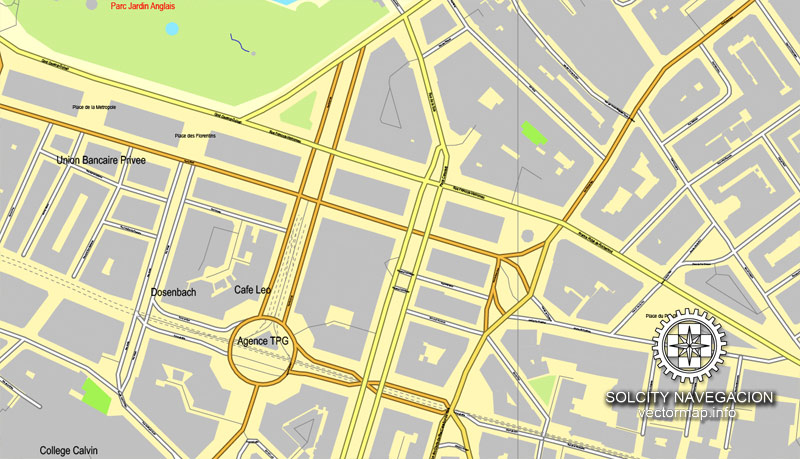
Geneva, Switzerland printable vector street City Plan map, full editable, Adobe Illustrator, full vector, scalable, editable, text format street names, 11,5 mb ZIP
All streets, all buildings.
PDF, DXF and other formats – on demand, same price, please, contact
Geneva, Switzerland.
This vector map of Geneva city is used as a basis for design, editing, and further printing.
This is the most detailed, exact map of Geneva city for high-quality printing and polygraphy. You can always clarify the map development date by contacting us.
For your convenience, all objects on Geneva vector city map are divided into layers. And the editing is very easy – colors, lines, etc.
You can easily add any objects needed (e.g. shops, salons, sale points, gas station or attraction) on any layer of Geneva vector map.
Geneva is the second-most populous city in Switzerland (after Zürich) and the most populous city of the Romandy, the French-speaking part of Switzerland. Situated where the Rhône exits Lake Geneva, it is the capital of the Republic and Canton of Geneva.
The municipality (ville de Genève) has a population (as of December 2017) of 200,548, and the canton (essentially the city and its inner-ring suburbs) has 495,249 residents. In 2014, the compact agglomération du Grand Genève had 946,000 inhabitants in 212 communities in both Switzerland and France. Within Swiss territory, the commuter area named “Métropole lémanique” contains a population of 1.26 million. This area is essentially spread east from Geneva towards the Riviera area (Vevey, Montreux) and north-east towards Yverdon-les-Bains, in the neighbouring canton of Vaud.
One of the advantages of Geneva city vector maps of our production is the relevance of cartographic data, we constantly update all our products.
This vector map of Geneva city is used by:
designers, layout designers, printers, advertisers and architects. Our product – vector maps – is designed for further editing and printing in large formats – from @Wall format (a few meters) to A-0 and A-1, A-2, A-3.
Geneva city map in vector format is used for design, urban planning, presentations and media visualizations.
Advertising and presentation map of Geneva city (usually the final designer marks the routes, and puts the client’s objects (shops, saloons, gas stations etc.)
The undoubted advantage is that people will NEVER throw out this advertising product – the map. In fact, as an advertising medium, a city map is the most “long-playing” of the well-known polygraphic advertising media, with the longest lifespan, and the maximum number of interactions with the customer.
For travelers, maps are sold at the airports and gas stations around the world. Often the source is our vector maps.
Take a look, who purchases our vector maps of Geneva city in “Our Clients and Friends” page – these are large and small companies, from super-brands like Volvo and Starbucks, to small design studios and printing houses.
Geneva is a global city, a financial centre, and a worldwide centre for diplomacy due to the presence of numerous international organizations, including the headquarters of many agencies of the United Nations and the Red Cross. Geneva hosts the highest number of international organizations in the world. It is also where the Geneva Conventions were signed, which chiefly concern the treatment of wartime non-combatants and prisoners of war.
In 2017, Geneva was ranked as the world’s fifteenth most important financial centre for competitiveness by the Global Financial Centres Index, fifth in Europe behind London, Zürich, Frankfurt and Luxembourg. A 2009 survey by Mercer found that Geneva has the third-highest quality of life of any city in the world (behind Vienna and Zürich for expatriates; it is narrowly outranked by Zürich). The city has been referred to as the world’s most compact metropolis and the “Peace Capital”. In 2017, Geneva was ranked as the seventh most expensive city in the world. Geneva was ranked third in purchasing power in a global cities ranking by UBS in 2018.
It’s very easy to work with vector maps of Geneva city, even for a not very experienced designer who can turn on and off the map layers, add new objects, change the colors of fill and lines according to customer requirements.
The undoubted advantage of Geneva city vector maps in printing is an excellent and detailed visualization, when customer can expand a large paper map and instantly define his location, find a landmark, an object or address on map, unlike using the popular electronic formats of Google and Yandex maps for example.
Printable vector maps of Geneva city are much more convenient and efficient than any electronic maps on your smartphone, because ALL DETAILS are displayed in the entire space of Geneva city map.
Useful tips on working with vector maps of cities and countries in Adobe Illustrator.
«V» – launches the Selection tool (cursor, black arrow), which makes active any vector line.
«А» – launches the Direct Selection tool (white cursor), allows you to select curve elements and drag them to the desired place.
«R» – activates the Rotate tool, which helps you rotating selected objects around the center point by 360 degrees.
«E» – gives you the opportunity to use the Eraser tool and erase unnecessary parts.
«X» – switches between Fill and Stroke in the Tools section. Try to get used to this hot key and
you will quickly understand that you can’t live and work without it.
Geography and climate
Topography
Geneva is located at 46°12′ North, 6°09′ East, at the south-western end of Lake Geneva, where the Rhône flows out. It is surrounded by three mountain chains, each belonging to the Jura: the Jura main range lies north-westward, the Vuache southward, and the Salève south-eastward.
The Geneva area seen from the Salève in France. The Jura mountains can be seen on the horizon.
Guides are not limited to vertical and horizontal in Adobe Illustrator. You can also create a diagonal guide for example. Moreover, you can turn any contours into guides. Select the outline and go to View > Guides > Make Guides (Create Guides), or simply press Cmd/Ctrl + 5. You can also turn the guides back into an editable object. Go to menu, View > Guides > Unlock Guides (Release Guides), select the guide you want to edit and select View > Guides > Release Guides (Reset Guides), or just press Cmd/Ctrl + Option / Alt + 5).
You will probably want to change the color scheme used on our Geneva vector city map.
To quickly and effectively play with colors.
Of course, you can do it manually, all objects in our Geneva city vector map are divided according to types and layers, and you can easily change the color gamma of vector objects in groups and layers.
But there is more effective way of working with the whole VECTOR MAP of Geneva city and all layers:
The overview dialog «Edit colors»/«Repaint Graphic Object» (this dialog box name can change depending on the context):
If you have selected a part or a layer of Geneva city vector map and open the dialog box by clicking the icon in the Control panel, on the Samples palette or the Color Catalog, or if you choose Edit > Edit Colors> Repaint Graphic Object, then the «Repaint Graphic Object» dialog box appears, and you get access to «Assign» and «Edit» tabs.
The city covers an area of 15.93 km2 (6.2 sq mi), while the area of the canton is 282 km2 (108.9 sq mi), including the two small exclaves of Céligny in Vaud. The part of the lake that is attached to Geneva has an area of 38 km2 (14.7 sq mi) and is sometimes referred to as petit lac (small lake). The canton has only a 4.5-kilometre-long (2.8 mi) border with the rest of Switzerland. Of 107.5 km (66.8 mi) of border, 103 are shared with France, the Département de l’Ain to the north and west and the Département de la Haute-Savoie to the south and east.
If a picture or a map fragment is not selected, and you open the dialog box by clicking the icon in the Control panel, on the Samples palette or in the Color Catalog, the «Edit Colors» dialog box appears and you can only access the «Edit» tab.
Regardless of the name at the top of the dialog box, the right-hand side always displays the color group of the current document, as well as two default color groups: Print Color and Grayscale. These color groups can be selected and used any time.
Create and edit color groups of Geneva city vector map, and also assign colors using the «Edit Colors»/ а «Repaint Graphic Object» dialog box.
A. Creating and editing of a color group on the «Edit» tab
B. Assigning colors on the «Assign» tab
C. Select a group of colors from the «Color groups» list
The option «Repaint a graphic object» in the lower part of the dialog box allows you to preview the colors on a selected layer of Vector map, or a group of elements, and specify whether its colors will be redefined when the dialog box is closed.
The main areas of the dialog box are:
«Edit»
The «Edit» tab is designed to create a new or edit the existing color groups.
The harmony rules Menu and the Color Wheel are used to conduct experiments with color harmonies. The color wheel shows how colors are related in color harmony, and the color bars allow you to view and manipulate an individual color values. In addition, you can adjust the brightness, add and remove colors, save color groups and view colors on the selected Vector Map of Geneva city or a separated layers.
«Assign»
The «Assign» tab is used to view and control on how the original colors are replaced with colors from the color group like your corporate colors in the Vector Map of Geneva city.
The assign color ability is provided only if the entire map, layer or fragment is selected in the document. You can specify which of new colors replace the current colors, whether the spot colors should be preserved and how colors are replaced (for example, you can replace colors completely or changing the color tone while maintaining the brightness). The «Assign» tab allows you to redefine colors in the Vector Map of Geneva city, or in separate layers and fragments using the current color group or reducing the number of colors in the current Vector Map.
Color groups
Is a list of all saved color groups for current document (the same groups appear in the «Samples» palette). You can edit and delete the existing color groups, as well as creating a new ones using the list of “Color Groups” in the dialog box. All changes appear in the «Samples» palette.
The highlighted color group shows, which color group is currently edited.
Any color group can be selected and edited, or used to redefine the colors in the selected vector map of Geneva city, its fragments or elements.
Saving a color group adds this group to the specified list.
Opening the «Edit Colors»/«Repaint Graphic Object» dialog box.
Open the «Edit Colors»/«Repaint Graphic Object» dialog box using one of the following methods:
«Edit»> «Edit Colors»> «Repaint Graphic object» or «Repaint With Style».
Use these commands if you need to edit the colors in the selected vector map of Geneva city.
«Repaint Graphic object» button on the «Control» panel.
Use this button if you need to adjust colors of Geneva city vector map using the а «Repaint graphic object» dialog box.
The specified button is available if the selected vector map or its fragment contains two or more colors.
Note. This color editing method is convenient for global color adjustment in a vector map, if global colors were not used when creating a City Map of Geneva.
The «Edit colors» button or «Edit or apply colors» on the «Color Catalog» palette
Click this button if you need to edit colors on the «Color Catalog» palette or edit and then apply them to the selected Vector Map of Geneva city or its fragment.
The «Edit color group» button or «Edit or apply color group» on the «Samples» palette.
Click this button if you need to edit the colors in the specific color group or edit and apply them to the selected Vector Map of Geneva city or a group of its elements, for example, the whole layer “Streets and lines”. You can also double-click the color group in the Samples panel to open the dialog box.
If the map file is too large and your computer freezes or even can’t open it quickly:
1. Try to reduce the color resolution of the video card (display) to 256 colors while working with a large map.
2. Using Windows Task Manager, select all the application you don’t need, while working with map, just turn them off.
3. Launch Adobe Illustrator. (DO NOT OPEN the vector map file)
4. Start the Windows Task Manager using administrator rights > Find the “Illustrator” process > set the «real time» priority,
5. Open the file. When you see the LEGACY FONT popup window – click “OK” (do not update). You can restore the TEXT later.
6. Can also be useful: When file is opened – Edit > Settings > Basic Settings > disable smoothing. /// It looks scary, but works quickly)))
We recommend saving the file in Adobe Illustrator 10 version. It’s much more stable when working with VERY BIG size files.
Of the land in the city, 0.24 km2 (0.093 sq mi), or 1.5%, is used for agricultural purposes, while 0.5 km2 (0.19 sq mi), or 3.1%, is forested. The rest of the land, 14.63 km2 (5.65 sq mi), or 91.8%, is built up (buildings or roads), 0.49 km2 (0.19 sq mi), or 3.1%, is either rivers or lakes and 0.02 km2 (4.9 acres), or 0.1%, is wasteland.
Of the built up area, industrial buildings made up 3.4%, housing and buildings made up 46.2% and transportation infrastructure 25.8%, while parks, green belts and sports fields made up 15.7%. Of the agricultural land, 0.3% is used for growing crops. Of the water in the municipality, 0.2% is composed of lakes and 2.9% is rivers and streams.
Confluence of the Rhône and the Arve
The altitude of Geneva is 373.6 metres (1,225.7 ft), and corresponds to the altitude of the largest of the Pierres du Niton, two large rocks emerging from the lake which date from the last ice age. This rock was chosen by General Guillaume Henri Dufour as the reference point for surveying in Switzerland. The second main river of Geneva is the Arve, which flows into the Rhône just west of the city centre. Mont Blanc can be seen from Geneva and is an hour’s drive from the city.
Small guide: How to work with the vector map?
You can: Mass select objects by type and color – for example, the objects type “building” (they are usually dark gray) – and remove them from the map, if you do not need them in your print or design project. You can also easily change the thickness of lines (streets), just bulk selection the road by the line color.
The streets are separated by type, for example, type “residential road” are usually white with a gray stroke. Highway usually orange with a brown or dark gray stroke.
All objects are divided by types: different types of roads and streets, polygons of buildings, landfills, urban areas, parks and more other.
It is easy to change the font of inscriptions, all or each individually. Also, just can be make and any other manipulation of objects on the vector map in Adobe illustrator format.
Important: All the proportions on the map are true, that is, the relative sizes of the objects are true, because Map is based on an accurate GPS projection, and It transated into the (usual for all) the Mercator projection.
You can easily change the color, stroke and fill of any object on the map, zoom without loss of quality Image Verification.
Select object

Bulk selection the same objects on the vector map

See the bulk selected objects on the vector map

Bulk delete buildungs from the vector map

Select residencial road (small street) on the vector map

Bulk selection the same lines (streets, roads) on the full map

Create fat lines of the streets on the vector maps (bulk action) 1

Create fat lines of the streets on the vector maps (bulk action) 2

Create fat lines of the streets on the vector maps (bulk action) 3

You can easily change the color, stroke and fill of any object on the map, zoom without loss of quality Image Verification.

 Author: Kirill Shrayber, Ph.D. FRGS
 map, V.07 fully editable Adobe Illustrator")

 Street Map editable Adobe Illustrator in layers")