Editable PDF Vector Country Map Romania, Topo Road map, Adobe PDF, full vector, scalable, editable, text format names, 25 mb ZIP
Map for publishing, design, printing, publications, arts, projects, presentations, for architects, designers and builders, business, logistics. The most exact and detailed map, Mercator Projection.
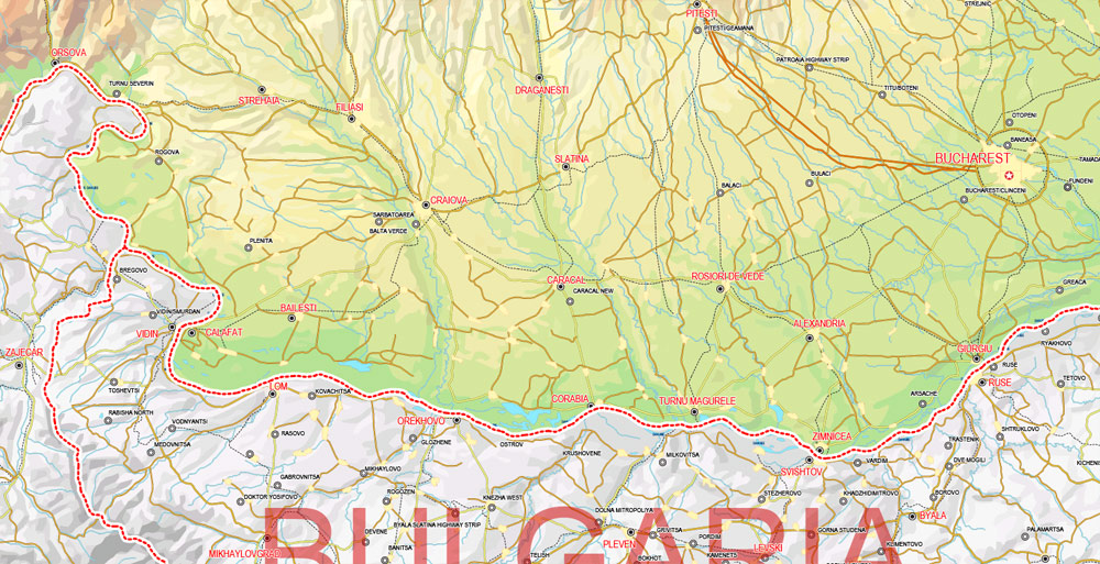
Layers: vector relief, roads, cities, names cities, water objects, urban areas, names water, flag and coat of arms, country borders.
You can edit this file by Adobe Illustrator, Adobe Acrobat, Corel Draw.
DXF, DWG, CDR and other formats – on request, same price, please, contact
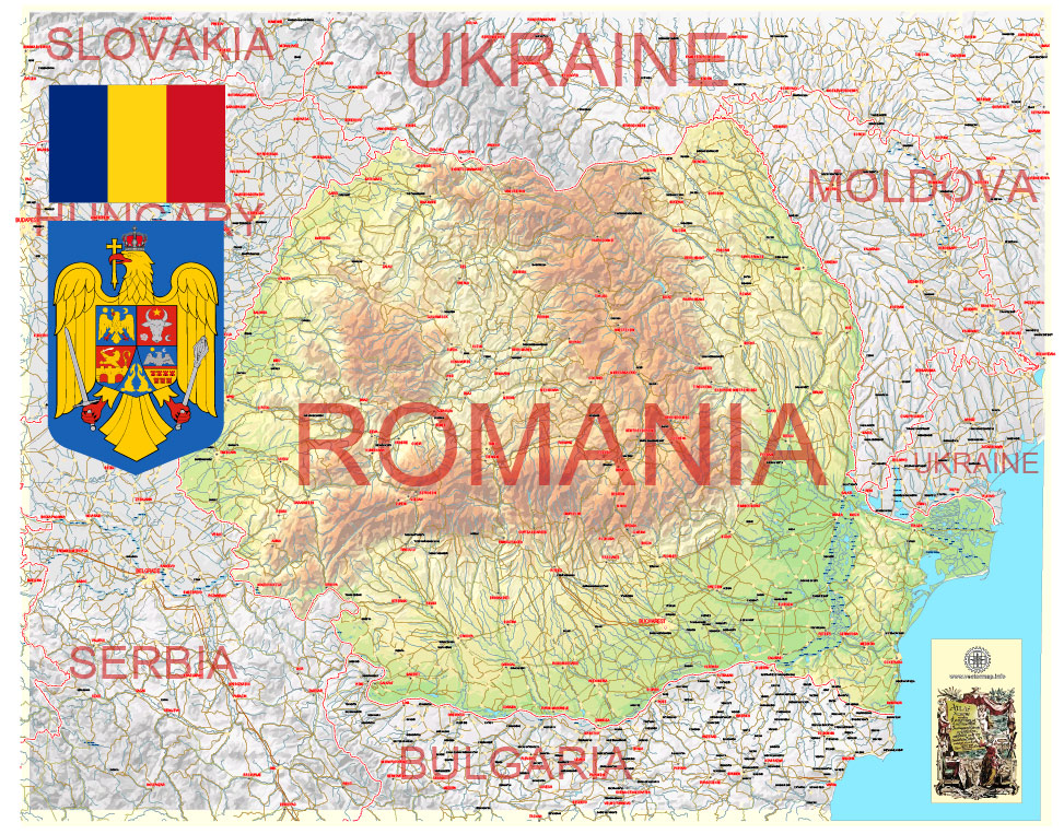
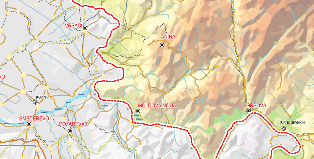
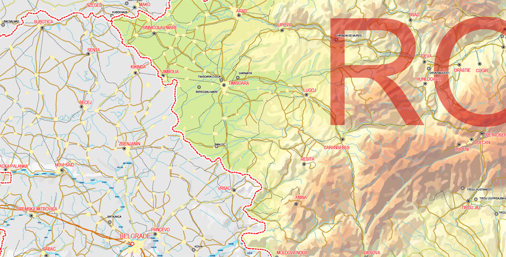
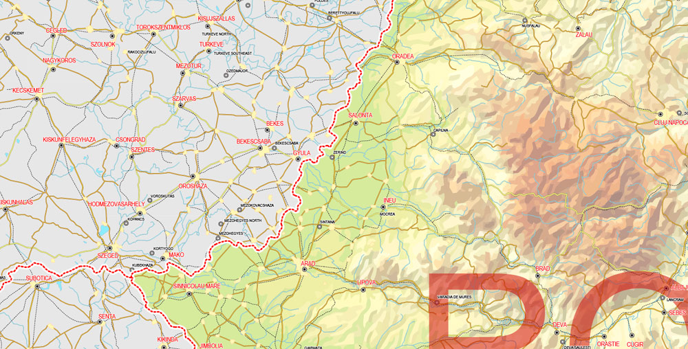
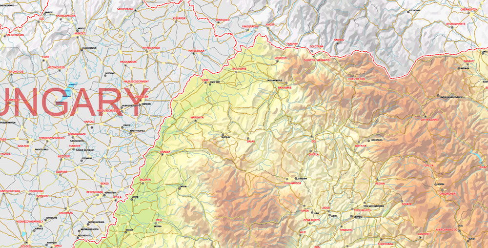
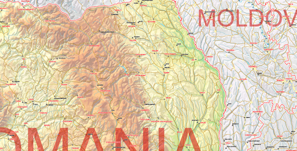
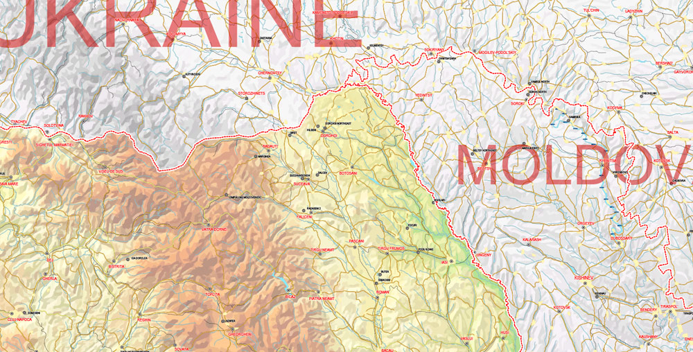
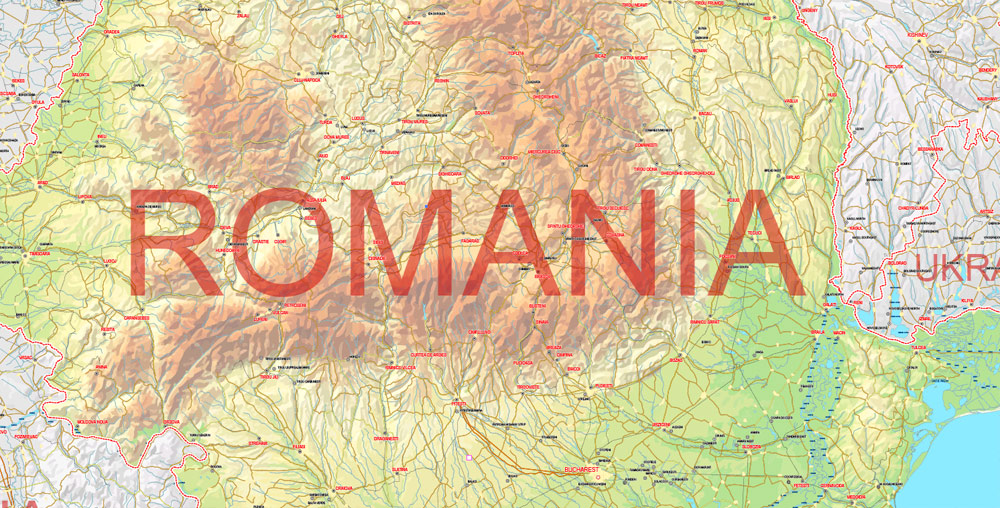
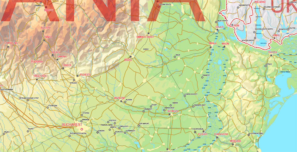
Romania.
This vector map of Romania is used as a basis for design, editing, and further printing.
This is the most detailed, exact map of Romania for high-quality printing and polygraphy. You can always clarify the map development date by contacting us.
For your convenience, all objects on Romania vector map are divided into layers. And the editing is very easy – colors, lines, etc.
You can easily add any objects needed (e.g. shops, salons, sale points, gas station or attraction) on any layer of Romania vector map.
One of the advantages of Romania vector maps of our production is the relevance of cartographic data, we constantly update all our products.
Romania is a country located at the crossroads of Central, Eastern, and Southeastern Europe. It borders the Black Sea to the southeast, Bulgaria to the south, Ukraine to the north, Hungary to the west, Serbia to the southwest, and Moldova to the east. It has a predominantly temperate-continental climate. With a total area of 238,397 square kilometres (92,046 sq mi), Romania is the 12th largest country and also the 7th most populous member state of the European Union, having almost 20 million inhabitants. Its capital and largest city is Bucharest and other major urban areas include Iași, Timișoara, Cluj-Napoca, and Constanța.
This vector map of Romania is used by:
designers, layout designers, printers, advertisers and architects. Our product – vector maps – is designed for further editing and printing in large formats – from @Wall format (a few meters) to A-0 and A-1, A-2, A-3.
The Romania map in vector format is used for design, urban planning, presentations and media visualizations.
The advertising and presentation map of Romania (usually the final designer marks the routes, and puts the client’s objects (shops, saloons, gas stations etc.)
The undoubted advantage is that people will NEVER throw out this advertising product – the map. In fact, as an advertising medium, a map is the most “long-playing” of the well-known polygraphic advertising media, with the longest lifespan, and the maximum number of interactions with the customer.
For travelers, maps are sold at the airports and gas stations around the world. Often the source is our vector maps.
Take a look, who purchases our vector maps of Romania in “Our Clients and Friends” page – these are large and small companies, from super-brands like Volvo and Starbucks, to small design studios and printing houses.
It’s very easy to work with vector maps of Romania city, even for a not very experienced designer who can turn on and off the map layers, add new objects, change the colors of fill and lines according to customer requirements.
The undoubted advantage of Romania vector maps in printing is an excellent and detailed visualization, when customer can expand a large paper map and instantly define his location, find a landmark, an object or address on map, unlike using the popular electronic formats of Google and Yandex maps for example.
Printable vector maps of Romania are much more convenient and efficient than any electronic maps on your smartphone, because ALL DETAILS are displayed in the entire space of Romania map.
Useful tips on working with vector maps of cities and countries in Adobe Illustrator.
«V» – launches the Selection tool (cursor, black arrow), which makes active any vector line.
«А» – launches the Direct Selection tool (white cursor), allows you to select curve elements and drag them to the desired place.
«R» – activates the Rotate tool, which helps you rotating selected objects around the center point by 360 degrees.
«E» – gives you the opportunity to use the Eraser tool and erase unnecessary parts.
«X» – switches between Fill and Stroke in the Tools section. Try to get used to this hot key and
you will quickly understand that you can’t live and work without it.
The River Danube, Europe’s second-longest river, rises in Germany’s Black Forest and flows in a general southeast direction for 2,857 km (1,775 mi), coursing through ten countries before emptying into Romania’s Danube Delta. The Carpathian Mountains, which cross Romania from the north to the southwest, include Moldoveanu Peak, at an altitude of 2,544 m (8,346 ft).
Guides are not limited to vertical and horizontal in Adobe Illustrator. You can also create a diagonal guide for example. Moreover, you can turn any contours into guides. Select the outline and go to View > Guides > Make Guides (Create Guides), or simply press Cmd/Ctrl + 5. You can also turn the guides back into an editable object. Go to menu, View > Guides > Unlock Guides (Release Guides), select the guide you want to edit and select View > Guides > Release Guides (Reset Guides), or just press Cmd/Ctrl + Option / Alt + 5).
You will probably want to change the color scheme used on our Romania vector map.
To quickly and effectively play with colors.
Of course, you can do it manually, all objects in our Romania vector map are divided according to types and layers, and you can easily change the color gamma of vector objects in groups and layers.
But there is more effective way of working with the whole VECTOR MAP of Romania and all layers:
The overview dialog «Edit colors»/«Repaint Graphic Object» (this dialog box name can change depending on the context):
If you have selected a part or a layer of Romania vector map and open the dialog box by clicking the icon in the Control panel, on the Samples palette or the Color Catalog, or if you choose Edit > Edit Colors> Repaint Graphic Object, then the «Repaint Graphic Object» dialog box appears, and you get access to «Assign» and «Edit» tabs.
If a picture or a map fragment is not selected, and you open the dialog box by clicking the icon in the Control panel, on the Samples palette or in the Color Catalog, the «Edit Colors» dialog box appears and you can only access the «Edit» tab.
Regardless of the name at the top of the dialog box, the right-hand side always displays the color group of the current document, as well as two default color groups: Print Color and Grayscale. These color groups can be selected and used any time.
Create and edit color groups of Romania vector map, and also assign colors using the «Edit Colors»/ а «Repaint Graphic Object» dialog box.
A. Creating and editing of a color group on the «Edit» tab
B. Assigning colors on the «Assign» tab
C. Select a group of colors from the «Color groups» list
The option «Repaint a graphic object» in the lower part of the dialog box allows you to preview the colors on a selected layer of Vector map, or a group of elements, and specify whether its colors will be redefined when the dialog box is closed.
Modern Romania was formed in 1859 through a personal union of the Danubian Principalities of Moldavia and Wallachia. The new state, officially named Romania since 1866, gained independence from the Ottoman Empire in 1877. Following World War I, when Romania fought on the side of the Allied powers, Bukovina, Bessarabia, Transylvania and parts of Banat, Crișana and Maramureș became part of the sovereign Kingdom of Romania. In June–August 1940, as a consequence of the Molotov–Ribbentrop Pact and Second Vienna Award, Romania was compelled to cede Bessarabia and Northern Bukovina to the Soviet Union, and Northern Transylvania to Hungary. In November 1940, Romania signed the Tripartite Pact and, consequently, in June 1941 entered World War II on the Axis side, fighting against the Soviet Union until August 1944, when it joined the Allies and recovered Northern Transylvania. Following the war, under the occupation of the Red Army’s forces, Romania became a socialist republic and member of the Warsaw Pact. After the 1989 Revolution, Romania began a transition towards democracy and a market economy.
The main areas of the dialog box are:
«Edit»
The «Edit» tab is designed to create a new or edit the existing color groups.
The harmony rules Menu and the Color Wheel are used to conduct experiments with color harmonies. The color wheel shows how colors are related in color harmony, and the color bars allow you to view and manipulate an individual color values. In addition, you can adjust the brightness, add and remove colors, save color groups and view colors on the selected Vector Map of Romania or a separated layers.
«Assign»
The «Assign» tab is used to view and control on how the original colors are replaced with colors from the color group like your corporate colors in the Vector Map of Romania city.
The assign color ability is provided only if the entire map, layer or fragment is selected in the document. You can specify which of new colors replace the current colors, whether the spot colors should be preserved and how colors are replaced (for example, you can replace colors completely or changing the color tone while maintaining the brightness). The «Assign» tab allows you to redefine colors in the Vector Map of Romania city, or in separate layers and fragments using the current color group or reducing the number of colors in the current Vector Map.
Color groups
Is a list of all saved color groups for current document (the same groups appear in the «Samples» palette). You can edit and delete the existing color groups, as well as creating a new ones using the list of “Color Groups” in the dialog box. All changes appear in the «Samples» palette.
The highlighted color group shows, which color group is currently edited.
Any color group can be selected and edited, or used to redefine the colors in the selected vector map of Romania city, its fragments or elements.
Saving a color group adds this group to the specified list.
Opening the «Edit Colors»/«Repaint Graphic Object» dialog box.
Open the «Edit Colors»/«Repaint Graphic Object» dialog box using one of the following methods:
«Edit»> «Edit Colors»> «Repaint Graphic object» or «Repaint With Style».
Use these commands if you need to edit the colors in the selected vector map of Romania city.
«Repaint Graphic object» button on the «Control» panel.
Use this button if you need to adjust colors of Romania vector map using the а «Repaint graphic object» dialog box.
The specified button is available if the selected vector map or its fragment contains two or more colors.
Note. This color editing method is convenient for global color adjustment in a vector map, if global colors were not used when creating a Map of Romania.
The «Edit colors» button or «Edit or apply colors» on the «Color Catalog» palette
Click this button if you need to edit colors on the «Color Catalog» palette or edit and then apply them to the selected Vector Map of Romania or its fragment.
The «Edit color group» button or «Edit or apply color group» on the «Samples» palette.
Click this button if you need to edit the colors in the specific color group or edit and apply them to the selected Vector Map of Romania or a group of its elements, for example, the whole layer “Streets and lines”. You can also double-click the color group in the Samples panel to open the dialog box.
If the map file is too large and your computer freezes or even can’t open it quickly:
1. Try to reduce the color resolution of the video card (display) to 256 colors while working with a large map.
2. Using Windows Task Manager, select all the application you don’t need, while working with map, just turn them off.
3. Launch Adobe Illustrator. (DO NOT OPEN the vector map file)
4. Start the Windows Task Manager using administrator rights > Find the “Illustrator” process > set the «real time» priority,
5. Open the file. When you see the LEGACY FONT popup window – click “OK” (do not update). You can restore the TEXT later.
6. Can also be useful: When file is opened – Edit > Settings > Basic Settings > disable smoothing. /// It looks scary, but works quickly)))
We recommend saving the file in Adobe Illustrator 10 version. It’s much more stable when working with VERY BIG size files.
The sovereign state of Romania is a developing country and ranks 52nd in the Human Development Index. It has the world’s 47th largest economy by nominal GDP and an annual economic growth rate of 7% (2017), the highest in the EU at the time. Following rapid economic growth in the early 2000s, Romania has an economy predominantly based on services, and is a producer and net exporter of machines and electric energy, featuring companies like Automobile Dacia and OMV Petrom. It has been a member of the United Nations since 1955, part of NATO since 2004, and part of the European Union since 2007. An overwhelming majority of the population identifies themselves as Eastern Orthodox Christians and are native speakers of Romanian, a Romance language.
Geography and climate
With an area of 238,397 square kilometres (92,046 sq mi), Romania is the largest country in Southeastern Europe and the twelfth-largest in Europe. It lies between latitudes 43° and 49° N and longitudes 20° and 30° E.
The terrain is distributed roughly equally between mountains, hills, and plains.
The Carpathian Mountains dominate the centre of Romania, with 14 mountain ranges reaching above 2,000 m or 6,600 ft, the highest of which is Moldoveanu Peak at 2,544 m or 8,346 ft. :11 They are surrounded by the Moldavian and Transylvanian plateaus and Carpathian Basin and Wallachian plains.
About 47% of the country’s land area is covered with natural and semi-natural ecosystems. There are almost 10,000 km2 (3,900 sq mi) (about 5% of the total area) of protected areas in Romania covering 13 national parks and three biosphere reserves.
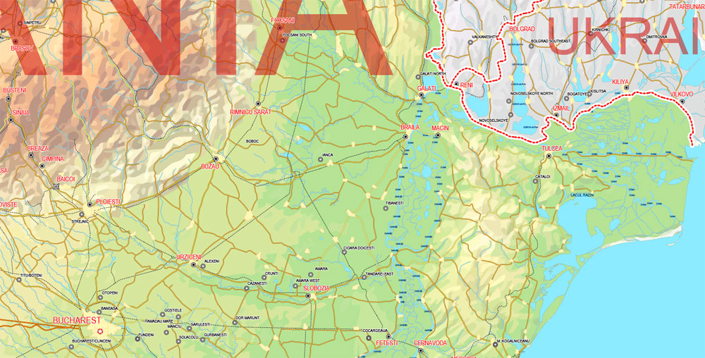
The Danube river forms a large part of the border with Serbia and Bulgaria, and flows into the Black Sea, forming the Danube Delta, which is the second-largest and best-preserved delta in Europe, and also a biosphere reserve and a biodiversity World Heritage Site. At 5,800 km2 (2,200 sq mi), the Danube Delta is the largest continuous marshland in Europe, and supports 1,688 different plant species alone.
Romania has one of the largest areas of undisturbed forest in Europe, covering almost 27% of the territory. Some 3,700 plant species have been identified in the country, from which to date 23 have been declared natural monuments, 74 missing, 39 endangered, 171 vulnerable, and 1,253 rare.
The fauna consists of 33,792 species of animals, 33,085 invertebrate and 707 vertebrate, with almost 400 unique species of mammals, birds, reptiles, and amphibians, including about 50% of Europe’s (excluding Russia) brown bears and 20% of its wolves.
With an area of 238,400 square kilometers, Romania is the twelfth-largest country in Europe. Located in Southeastern Europe, bordering on the Black Sea, the country is halfway between the equator and the North Pole and equidistant from the westernmost part of Europe—the Atlantic Coast—and the most easterly—the Ural Mountains. Romania has 3,195 kilometers of border. Republic of Moldova and Ukraine lie to the east, Bulgaria lies to the south, and Serbia and Hungary to the west. In the southeast, 245 kilometers of sea coastline provide an important outlet to the Black Sea and the Atlantic Ocean.
Topography
Romania’s natural landscape is almost evenly divided among mountains (31 percent), plains (33 percent), and hills (36 percent). These varied relief forms spread rather symmetrically from the Carpathian Mountains, which reach elevations of more than 2,500 meters, to the Danube Delta, which is just a few meters above sea level.
The arc of the Carpathians extends over 1,000 kilometers through the center of the country, covering an area of 71,000 square kilometers. These mountains are of low to medium altitude and are no wider than 100 kilometers. They are deeply fragmented by longitudinal and transverse valleys and crossed by several major rivers. These features and the fact that there are many summit passes—some at altitudes up to 2,256 meters—have made the Carpathians less of a barrier to movement than other European ranges. Another distinguishing feature is the many eroded platforms that provide tableland at relatively high altitudes. There are permanent settlements here at above 1,200 meters.
Romania’s Carpathians are differentiated into three ranges: the Eastern Carpathians, the Southern Carpathians or Transylvanian Alps, and the Western Romanian Carpathians. Each of these ranges has important distinguishing features. The Eastern Carpathians are composed of three parallel ridges that run from northwest to southeast. The westernmost ridge is an extinct volcanic range with many preserved cones and craters. The range has many large depressions, in the largest of which the city of Brașov is situated. Important mining and industrial centers as well as agricultural areas are found within these depressions. The Eastern Carpathians are covered with forests—some 32 percent of the country’s woodlands are there. They also contain important ore deposits, including gold and silver, and their mineral water springs feed numerous health resorts.
Romanian Sphinx situated on the plateau of Bucegi Mountains at 2,216 m. altitude, measures 8 meters in height and 12 meters in width
The Southern Carpathians offer the highest peaks at Moldoveanu Peak (2,544 m) and Negoiu (2,535 m) and more than 150 glacial lakes. They have large grassland areas and some woodlands but few large depressions and subsoil resources. At higher elevations, the wind and rain have turned the rocks into spectacular figures such as the Sphinx and Babele.
The region was crisscrossed by an ancient network of trans-Carpathian roads, and vestiges of the old Roman Way are still visible. Numerous passes and the valleys of the Olt, Jiu, and Danube rivers provide routes for roads and railways through the mountains.
The Western Romanian Carpathians are the lowest of the three ranges and are fragmented by many deep structural depressions. They have historically functioned as “gates,” which allow easy passage but can be readily defended. The most famous of these is the Iron Gate on the Danube. The Western Romanian Carpathians are the most densely settled, and it is in the northernmost area of this range, the Apuseni Mountains, that permanent settlements can be found at the highest altitudes.
Enclosed within the great arc of the Carpathians lie the undulating plains and low hills of the Transylvanian Plateau—the largest tableland in the country and the center of Romania. This important agricultural region also contains large deposits of methane gas and salt. To the south and east of the Carpathians, the Sub-Carpathians form a fringe of rolling terrain ranging from 396 to 1,006 meters in elevation. This terrain is matched in the west by the slightly lower Western Hills. The symmetry of Romania’s relief continues with the Getic Tableland to the south of the Sub-Carpathians, the Moldavian Tableland in the east between the Sub-Carpathians and the Prut River, and the Dobrujan Tableland in the southeast between the Danube and the Black Sea. The Sub-Carpathians and the tableland areas provide good conditions for human settlement and are important areas for fruit growing, viticulture, and other agricultural activity. They also contain large deposits of brown coal and natural gas.
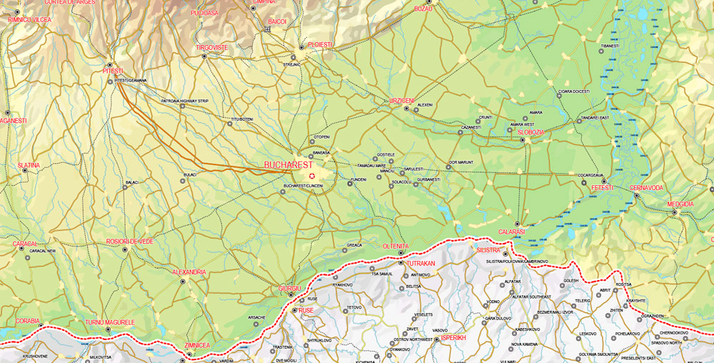
Beyond the Carpathian foothills and tablelands, the plains spread south and west. In the southern parts of the country, the lower Danube Plain is divided by the Olt River; east of the river lies the Wallachian Plain, and to the west is the Oltenian or Western Plain. The land here is rich with chernozemic soils and forms Romania’s most important farming region. Irrigation is widely used, and marshlands in the Danube’s floodplain have been diked and drained to provide additional tillable land.
Romania’s lowest land is found on the northern edge of the Dobruja region in the Danube Delta. The delta is a triangular swampy area of marshes, floating reed islands, and sandbanks, where the Danube ends its trek of almost 3,000 kilometers and divides into three frayed branches before emptying into the Black Sea. The Danube Delta provides a large part of the country’s fish production, and its reeds are used to manufacture cellulose. The region also serves as a nature preserve for rare species of plant and animal life including migratory birds.
Romania
Country in the Balkans
Romania is a southeastern European country known for the forested region of Transylvania, ringed by the Carpathian Mountains. Its preserved medieval towns include Sighişoara, and there are many fortified churches and castles, notably clifftop Bran Castle, long associated with the Dracula legend. Bucharest, the country’s capital, is the site of the gigantic, Communist-era Palatul Parlamentului government building.
Capital: Bucharest
Dialing code: +40
Capital and largest city: Bucharest; 44°25′N 26°06′E / 44.417°N 26.100°E
Currency: Romanian leu
Free vector maps:

Free download printable map Europe vector Adobe Illustrator >>>
Free download printable PDF map Europe vector Adobe PDF >>>
Small guide: How to work with the vector map?
You can: Mass select objects by type and color – for example, the objects type “building” (they are usually dark gray) – and remove them from the map, if you do not need them in your print or design project. You can also easily change the thickness of lines (streets), just bulk selection the road by the line color.
The streets are separated by type, for example, type “residential road” are usually white with a gray stroke. Highway usually orange with a brown or dark gray stroke.
It is easy to change the font of inscriptions, all or each individually. Also, just can be make and any other manipulation of objects on the vector map in Adobe illustrator format.
Important: All the proportions on the map are true, that is, the relative sizes of the objects are true, because Map is based on an accurate GPS projection, and It transated into the (usual for all) the Mercator projection.
You can easily change the color, stroke and fill of any object on the map, zoom without loss of quality Image Verification.
Select object

Bulk selection the same objects on the vector map

See the bulk selected objects on the vector map

Bulk delete buildungs from the vector map

Select residencial road (small street) on the vector map

Bulk selection the same lines (streets, roads) on the full map

Create fat lines of the streets on the vector maps (bulk action) 1

Create fat lines of the streets on the vector maps (bulk action) 2

Create fat lines of the streets on the vector maps (bulk action) 3

You can easily change the color, stroke and fill of any object on the map, zoom without loss of quality Image Verification.

 Author: Kirill Shrayber, Ph.D. FRGS